

Coney Island Creek
Encyclopedia

Sea
A sea generally refers to a large body of salt water, but the term is used in other contexts as well. Most commonly, it means a large expanse of saline water connected with an ocean, and is commonly used as a synonym for ocean...
inlet
Inlet
An inlet is a narrow body of water between islands or leading inland from a larger body of water, often leading to an enclosed body of water, such as a sound, bay, lagoon or marsh. In sea coasts an inlet usually refers to the actual connection between a bay and the ocean and is often called an...
s in Brooklyn
Brooklyn
Brooklyn is the most populous of New York City's five boroughs, with nearly 2.6 million residents, and the second-largest in area. Since 1896, Brooklyn has had the same boundaries as Kings County, which is now the most populous county in New York State and the second-most densely populated...
, New York City
New York City
New York is the most populous city in the United States and the center of the New York Metropolitan Area, one of the most populous metropolitan areas in the world. New York exerts a significant impact upon global commerce, finance, media, art, fashion, research, technology, education, and...
, one separating Coney Island from the neighborhoods of Gravesend
Gravesend, Brooklyn
Gravesend is a neighborhood in the south-central section of the New York City borough of Brooklyn, USA.The derivation of the name is unclear. Some speculate that it was named after the English seaport of Gravesend, Kent. An alternative explanation suggests that it was named by Willem Kieft for the...
and Bath Beach
Bath Beach, Brooklyn
Bath Beach is a neighborhood in the New York City Borough of Brooklyn in the United States. It is located at the southwestern edge of the borough on Gravesend Bay.-Geography:...
, the other separating the neighborhoods of Sheepshead Bay
Sheepshead Bay, Brooklyn
Sheepshead Bay is a bay separating the mainland of Brooklyn, New York City from the eastern portion of Coney Island, the latter originally a barrier island but now effectively an extension of the mainland with peninsulas both east and west...
and Manhattan Beach
Manhattan Beach, Brooklyn
Manhattan Beach is a residential neighborhood in the New York City borough of Brooklyn. It is bounded by the Atlantic Ocean to the south and east, by Sheepshead Bay on the north, and Brighton Beach to the west. Traditionally known as an Italian and Ashkenazi Jewish neighborhood, it is also home to...
. Prior to construction of the Shore Parkway
Belt Parkway
The Belt System is a series of connected limited-access highways that form a belt-like circle around the New York City boroughs of Brooklyn and Queens. The system comprises four officially separate parkways; however, three of the four are signed as the Belt Parkway...
in the 1950s, Coney Island Creek was a strait
Strait
A strait or straits is a narrow, typically navigable channel of water that connects two larger, navigable bodies of water. It most commonly refers to a channel of water that lies between two land masses, but it may also refer to a navigable channel through a body of water that is otherwise not...
connecting Gravesend Bay and Sheepshead Bay, making Coney Island an actual island.
History
Coney Island Creek was minimally navigable and in the early 20th century the City of New York developed plans to widen, straighten and deepen it as the Gravesend Ship Canal. Those plans never came to fruition. Instead, a portion of the creek was filled in, making Coney Island a peninsulaPeninsula
A peninsula is a piece of land that is bordered by water on three sides but connected to mainland. In many Germanic and Celtic languages and also in Baltic, Slavic and Hungarian, peninsulas are called "half-islands"....
.
Geography
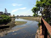
The western inlet of Coney Island Creek extends eastward from Gravesend Bay to Shell Road. The path of the landfill follows Shore Parkway, Guider Avenue, and the triangular block between Neptune Avenue and Cass Place.The eastern inlet picks up at Shore Boulevard and gradually widens into Sheepshead Bay.Access
The western inlet can be seen from street bridges at Cropsey Avenue (between Bay 54th Street and Hart Place) and Stillwell Avenue (between Shore Parkway and Neptune Avenue), and from the DD (New York City Subway service)
The D Sixth Avenue Express is a rapid transit service of the New York City Subway. It is colored orange on route signs, station signs, and the official subway map, since it uses the IND Sixth Avenue Line through Manhattan....
/N
N (New York City Subway service)
The N Broadway Local is a service of the New York City Subway. Its route bullet is colored yellow, which appears on station signs and the NYC Subway map, as it represents a service provided on the BMT Broadway Line through Manhattan....
New York City Subway
New York City Subway
The New York City Subway is a rapid transit system owned by the City of New York and leased to the New York City Transit Authority, a subsidiary agency of the Metropolitan Transportation Authority and also known as MTA New York City Transit...
lines several yards east of Stillwell Avenue (and just north of the Coney Island--Stillwell Avenue Station). The inlet can also be seen through the fence of a parking lot on Neptune Avenue near West 12th Street, and along much of Shell Road between Neptune and Shore Parkway. It remains mostly undeveloped and has become polluted, running along private industrial property and several acres owned by Keyspan
KeySpan
KeySpan Corporation, now part of National Grid USA, was the fifth largest distributor of natural gas in the United States. KeySpan was formed in 1998 as result of the merger of Brooklyn Union Gas Company and Long Island Lighting Company...
, the local electricity provider. Marine traffic is restricted by a cable net between Cropsey and Stillwell Avenues.
The eastern inlet, spanned by a pedestrian
Pedestrian
A pedestrian is a person traveling on foot, whether walking or running. In some communities, those traveling using roller skates or skateboards are also considered to be pedestrians. In modern times, the term mostly refers to someone walking on a road or footpath, but this was not the case...
pontoon bridge
Pontoon bridge
A pontoon bridge or floating bridge is a bridge that floats on water and in which barge- or boat-like pontoons support the bridge deck and its dynamic loads. While pontoon bridges are usually temporary structures, some are used for long periods of time...
at Sheepshead Bay Road, has been widened and developed with promenades, docks, and restaurants and is referred to by residents of Sheepshead Bay and Manhattan Beach simply as "the canal." It can be visited by car from the Belt Parkway (exits 8 and 9), or by subway, from the Sheepshead Bay
Sheepshead Bay (BMT Brighton Line)
Sheepshead Bay is an express station on the BMT Brighton Line of the New York City Subway. It is located in the Sheepshead Bay neighborhood of Brooklyn. It is served by the Q train at all times and by the B train on weekdays....
Station of the B
B (New York City Subway service)
The B Sixth Avenue Express is a rapid transit service of the New York City Subway. It is colored orange on route signs, station signs, and the official subway map, since it runs over the IND Sixth Avenue Line in Manhattan....
/Q
Q (New York City Subway service)
The Q Broadway Express is a service of the New York City Subway. It is colored yellow on the route sign, on station signs and the official subway map, as it represents a service provided on the BMT Broadway Line through Manhattan....
elevated subway line. Marine traffic is restricted by the pedestrian bridge.