
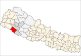
Bardiya District
Encyclopedia
Bardiya District
Bardiya District' onMouseout='HidePop("34028")' href="/topics/Districts_of_Nepal">districts of Nepal
, is part of Bheri Zone
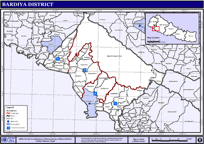
and is headquartered at the city of Gularia
. The district covers an area of 2,025 km² and according to the 2001 census the population was 382,649.
, south of Surkhet district
, east of Kailali district
of Seti zone
Bardiya District' onMouseout='HidePop("34028")' href="/topics/Districts_of_Nepal">districts of Nepal
Districts of Nepal
Nepal's 14 administrative zones are subdivided into 75 districts . These districts are listed below, by zone...
, is part of Bheri Zone
Bheri Zone
Bheri Anchal in the Mid-Western Development Region of Nepal. Nepalgunj is the administrative headquarters.Cities and towns are Narayan, Jajarkot and Chhinchu in the "hills"; Nepalgunj, Gularia and Kohalpur in Terai; Birendranagar in Surkhet Valley in the Inner Terai.Bheri Zone is divided into five...
and is headquartered at the city of Gularia
Gularia
Gularia is a town and capital of Bardiya District in the Bheri Zone of south-western Nepal. At the time of the 1991 Nepal census it had a population of 14,999 and had 2,418 houses in the town.It lies at an elevation of 187 metres....
. The district covers an area of 2,025 km² and according to the 2001 census the population was 382,649.
Geography
Bardiya lies in Bheri zone in the mid western region of Nepal. It covers 2025 square kilometers and lies west of Banke districtBanke District
-Geography:Banke is bordered on the west by Bardiya district. Rapti zone's Salyan and Dang Deukhuri Districts border to the north and east. To the south lies Uttar Pradesh, India; specifically Shravasti and Bahraich districts of Awadh. East of Nepalganj the international border follows the...
, south of Surkhet district
Surkhet District
-Village Development Committees :*Agragaun*Awalaching*Babiyachaur*Bajedichaur*Betan*Bidyapur*Bijaura*Birendranagar*Chapre*Chhinchu*Dahachaur*Dandakhali*Dasarathpur*Dharapani*Gadi...
, east of Kailali district
Kailali District
Kailali District of 616,697. Dhangadhi is a center of attraction of not only Kailali district but of the whole seti zone. The district also contains Tikapur Park, one of the biggest parks in Nepal, and Godha-Ghodi Tal lake.-Towns and villages:Baliya...
of Seti zone
Seti Zone
Seti ZoneSeti ZoneSeti ZoneSeti ZoneSeti ZoneSeti ZoneSeti ZoneSeti ZoneSeti Zone' onMouseout='HidePop("87169")' href="/topics/Uttar_Pradesh">Uttar Pradesh
, India
; specifically the Lakhimpur
and Bahraich district
s of Awadh
.
Most of Bardiya is in the fertile Terai
plains, covered with agricultural
land and forest
. The northernmost part of the district extends into the Churiya or Siwalik Hills
. Bardiya National Park covers 968 km2 occupies most of the northern half of the district. This park is the largest undisturbed wilderness in Nepal's Terai. It provides forest, grassland and riverine habitat for engendered mammal, bird and reptile species. More than 30 species of mammals and more than 250 of birds have been recorded.
Most people living in this district are farmers. The district headquarters Gularia
lies on the Babai River. The Karnali, one of Nepal's largest rivers, divides into multiple branches when it reaches the Terai. The westernmost branch forms the boundary between Bardiya and Kailali districts. An eastern branch is called the Geruwa. The endangered Gangetic dolphin was often seen in its waters, but populations have been declining.
in Sugauli Treaty
. Later during the administration of Jang Bahadur Rana it was returned to Nepal along with Banke, Kailali and Kanchanpur
. In the early twentieth century, Bardiya was still covered with forest and sparsely populated with indigenous tribal people called Tharu. Additional Tharus immigrated west from Dang and Deukhuri Valleys after they were displaced by Nepali
-speaking peoples from the hills. Later these hill people also migrated into Bardiya, however Tharu from Dang and Deukhuri still make up a majority of Bardiya's population. Other tribals called Sonaha live near the Karnali River and western periphery of Bardia National Park, who are historially engaged in extracting golden ores from sediments of river and fishing.
 Badalpur
,
Baganaha
,
Baniyabhar
,
Belawa
,
Bhimapur
,
Daulatpur,
Deudakala
,
Dhadhawar
,
Dhodhari
,
Gola
,
Gulariya
,
Jamuni
,
Kalika
,
Khairapur
,
Khairi Chandanpur
,
Magaragadi
,
Mahamadpur
,
Manau
,
Manpur Mainapokhar
,
Manpur Tapara
,
Mathurahardwar
,
Motipur
,
Naya Gaun
,
Neulapur
,
Padanaha
,
Pasupatinagar
,
Patabhar
,
Rajapur
,
Saneshree
,
Sivapur
,
Sorhawa
,
Suryapatawa
,
Taratal
,
Thakudwara
Uttar Pradesh
Uttar Pradesh abbreviation U.P. , is a state located in the northern part of India. With a population of over 200 million people, it is India's most populous state, as well as the world's most populous sub-national entity...
, India
India
India , officially the Republic of India , is a country in South Asia. It is the seventh-largest country by geographical area, the second-most populous country with over 1.2 billion people, and the most populous democracy in the world...
; specifically the Lakhimpur
Lakhimpur district
Lakhimpur is an administrative district in the state of Assam in India. The district headquarters are located at North Lakhimpur.- History :...
and Bahraich district
Bahraich District
Bahraich District is one of the districts of Uttar Pradesh state of India, and Bahraich town is the district headquarters. Bahraich District is a part of Devipatan Division.-History:...
s of Awadh
Awadh
Awadh , also known in various British historical texts as Oudh or Oude derived from Ayodhya, is a region in the centre of the modern Indian state of Uttar Pradesh, which was before independence known as the United Provinces of Agra and Oudh...
.
Most of Bardiya is in the fertile Terai
Terai
The Terai is a belt of marshy grasslands, savannas, and forests located south of the outer foothills of the Himalaya, the Siwalik Hills, and north of the Indo-Gangetic Plain of the Ganges, Brahmaputra and their tributaries. The Terai belongs to the Terai-Duar savanna and grasslands ecoregion...
plains, covered with agricultural
Agriculture
Agriculture is the cultivation of animals, plants, fungi and other life forms for food, fiber, and other products used to sustain life. Agriculture was the key implement in the rise of sedentary human civilization, whereby farming of domesticated species created food surpluses that nurtured the...
land and forest
Forest
A forest, also referred to as a wood or the woods, is an area with a high density of trees. As with cities, depending where you are in the world, what is considered a forest may vary significantly in size and have various classification according to how and what of the forest is composed...
. The northernmost part of the district extends into the Churiya or Siwalik Hills
Siwalik Hills
The Sivalik hills is a mountain range of the outer Himalayas also known as Manak Parbat in ancient times. Shivalik literally means 'tresses of Shiva’. This range is about long enclosing an area that starts almost from the Indus and ends close to the Brahmaputra, with a gap of about between the...
. Bardiya National Park covers 968 km2 occupies most of the northern half of the district. This park is the largest undisturbed wilderness in Nepal's Terai. It provides forest, grassland and riverine habitat for engendered mammal, bird and reptile species. More than 30 species of mammals and more than 250 of birds have been recorded.
Most people living in this district are farmers. The district headquarters Gularia
Gularia
Gularia is a town and capital of Bardiya District in the Bheri Zone of south-western Nepal. At the time of the 1991 Nepal census it had a population of 14,999 and had 2,418 houses in the town.It lies at an elevation of 187 metres....
lies on the Babai River. The Karnali, one of Nepal's largest rivers, divides into multiple branches when it reaches the Terai. The westernmost branch forms the boundary between Bardiya and Kailali districts. An eastern branch is called the Geruwa. The endangered Gangetic dolphin was often seen in its waters, but populations have been declining.
History
Bardiya was part of Nepal before it was ceded to the British East India CompanyBritish East India Company
The East India Company was an early English joint-stock company that was formed initially for pursuing trade with the East Indies, but that ended up trading mainly with the Indian subcontinent and China...
in Sugauli Treaty
Sugauli Treaty
The Sugauli Treaty was signed on December 2, 1815 and ratified by March 4, 1816, between the British East India Company and Nepal, which was a kingdom during that era. This ended the second British invasion of the Himalayan kingdom during the Anglo-Nepalese War...
. Later during the administration of Jang Bahadur Rana it was returned to Nepal along with Banke, Kailali and Kanchanpur
Kanchanpur District
-Basic statistics:* District: Kanchanpur* Headquarters: Mahendranagar* Area: 1610 km²* Total Population: 377,899* Literacy rate: 57.60% -Political divisions:* Political constituencies: 4...
. In the early twentieth century, Bardiya was still covered with forest and sparsely populated with indigenous tribal people called Tharu. Additional Tharus immigrated west from Dang and Deukhuri Valleys after they were displaced by Nepali
Nepali language
Nepali or Nepalese is a language in the Indo-Aryan branch of the Indo-European language family.It is the official language and de facto lingua franca of Nepal and is also spoken in Bhutan, parts of India and parts of Myanmar...
-speaking peoples from the hills. Later these hill people also migrated into Bardiya, however Tharu from Dang and Deukhuri still make up a majority of Bardiya's population. Other tribals called Sonaha live near the Karnali River and western periphery of Bardia National Park, who are historially engaged in extracting golden ores from sediments of river and fishing.
Towns and villages
Badalpur
Badalpur is a village in Jaunpur district in the state of Uttar Pradesh, in Northern India. At the time of the 2001 census it had a population of 2,000 and included 250 houses.-References:...
,
Baganaha
Baganaha
Baganaha is a village development committee in Bardiya District in the Bheri Zone of south-western Nepal. At the time of the 1991 Nepal census it had a population of 8,975 and had 1057 houses in the town....
,
Baniyabhar
Baniyabhar
Baniyabhar is a village development committee in Bardiya District in the Bheri Zone of south-western Nepal. At the time of the 1991 Nepal census it had a population of 10,652 and had 1123 houses in the town....
,
Belawa
Belawa
Belawa is a village development committee in Bardiya District in the Bheri Zone of south-western Nepal. At the time of the 1991 Nepal census it had a population of 9,894 and had 1558 houses in the town....
,
Bhimapur
Bhimapur
Bhimapur is a village development committee in Bardiya District in the Bheri Zone of south-western Nepal. At the time of the 1991 Nepal census it had a population of 8,057 and had 1012 houses in the town....
,
Daulatpur,
Deudakala
Deudakala
Deudakala is a village development committee in Bardiya District in the Bheri Zone of south-western Nepal. At the time of the 1991 Nepal census it had a population of 11,625 and had 1740 houses in the town....
,
Dhadhawar
Dhadhawar
Dhadhawar is a village development committee in Bardiya District in the Bheri Zone of south-western Nepal. At the time of the 1991 Nepal census it had a population of 12,693 and had 1741 houses in the town....
,
Dhodhari
Dhodhari
Dhodhari is a village development committee in Bardiya District in the Bheri Zone of south-western Nepal. At the time of the 1991 Nepal census it had a population of 10,568 and had 1810 houses in the town....
,
Gola
Gola, Nepal
Gola, Nepal is a village development committee in Bardiya District in the Bheri Zone of south-western Nepal. At the time of the 1991 Nepal census it had a population of 5,340 and had 694 houses in the town....
,
Gulariya
Gularia
Gularia is a town and capital of Bardiya District in the Bheri Zone of south-western Nepal. At the time of the 1991 Nepal census it had a population of 14,999 and had 2,418 houses in the town.It lies at an elevation of 187 metres....
,
Jamuni
Jamuni
Jamuni is a village development committee in Bardiya District in the Bheri Zone of south-western Nepal. At the time of the 1991 Nepal census it had a population of 9,584 and had 1648 houses in the town.Jamuni might also refer to the color purple in Hindi....
,
Kalika
Kalika, Bardiya
Kalika is a village development committee in Bardiya District in the Bheri Zone of south-western Nepal. At the time of the 1991 Nepal census it had a population of 7,547 and had 1305 houses in the town....
,
Khairapur
Khairapur
Khairapur is a town in Bardiya District in the Bheri Zone of south-western Nepal. At the time of the 1991 Nepal census it had a population of 6,568 and had 1192 houses in the town....
,
Khairi Chandanpur
Khairi Chandanpur
Khairi Chandanpur is a village development committee in Bardiya District in the Bheri Zone of south-western Nepal. At the time of the 1991 Nepal census it had a population of 5,303 and had 656 houses in the town....
,
Magaragadi
Magaragadi
Magaragadi is a village development committee in Bardiya District in the Bheri Zone of south-western Nepal. At the time of the 1991 Nepal census it had a population of 13,327 and had 1741 houses in the town....
,
Mahamadpur
Mahamadpur, Bheri
Mahamadpur is a Village Development Committee in Bardiya District in the Bheri Zone of south-western Nepal. At the time of the 1991 Nepal census it had a population of 8,191 and had 1152 houses in the town....
,
Manau
Manau, Nepal
Manau is a village development committee in Bardiya District in the Bheri Zone of south-western Nepal. At the time of the 1991 Nepal census it had a population of 5,741 and had 833 houses in the town....
,
Manpur Mainapokhar
Manpur Mainapokhar
Manpur Mainapokhar is a village development committee in Bardiya District in the Bheri Zone of south-western Nepal. At the time of the 1991 Nepal census it had a population of 6,841 and had 951 houses in the town....
,
Manpur Tapara
Manpur Tapara
Manpur Tapara is a village development committee in Bardiya District in the Bheri Zone of south-western Nepal. It is almost at the centre of river island called Bhawara Tappu of Karnali River. Badalpur village development committee lies north of Manpur Tapara...
,
Mathurahardwar
Mathurahardwar
Mathurahardwar is a village development committee in Bardiya District in the Bheri Zone of south-western Nepal. At the time of the 1991 Nepal census it had a population of 9,064 and had 1405 houses in the town....
,
Motipur
Motipur, Nepal
Motipur is a village development committee in Bardiya District in the Bheri Zone of south-western Nepal. At the time of the 1991 Nepal census it had a population of 14,760 and had 2151 houses in the town....
,
Naya Gaun
Naya Gaun, Bheri
Naya Gaun is a Village Development Committee in Bardiya District in the Bheri Zone of south-western Nepal. At the time of the 1991 Nepal census it had a population of 4,741 and had 544 houses in the town....
,
Neulapur
Neulapur
Neulapur is a village development committee in Bardiya District in the Bheri Zone of south-western Nepal. At the time of the 1991 Nepal census it had a population of 8,194 and had 1053 houses in the town....
,
Padanaha
Padanaha
Padanaha is a village development committee in Bardiya District in the Bheri Zone of south-western Nepal. At the time of the 1991 Nepal census it had a population of 7,186 and had 888 houses in the town....
,
Pasupatinagar
Pasupatinagar
Pasupatinagar is a village development committee in Bardiya District in the Bheri Zone of south-western Nepal. At the time of the 1991 Nepal census it had a population of 4,766 and had 613 houses in the town....
,
Patabhar
Patabhar
Patabhar is a village development committee in Bardiya District in the Bheri Zone of south-western Nepal. At the time of the 1991 Nepal census it had a population of 10,488 and had 1241 houses in the town....
,
Rajapur
Rajapur, Nepal
Rajapur is a village development committee in Bardiya District in the Bheri Zone of south-western Nepal. At the time of the 1991 Nepal census it had a population of 9,545 and had 1298 houses in the town....
,
Saneshree
Saneshree
Saneshree is a village development committee in Bardiya District in the Bheri Zone of south-western Nepal. At the time of the 1991 Nepal census it had a population of 12,542 and had 2266 houses in the town....
,
Sivapur
Sivapur
Sivapur is a village development committee in Bardiya District in the Bheri Zone of south-western Nepal. At the time of the 1991 Nepal census it had a population of 5,639 and had 725 houses in the town....
,
Sorhawa
Sorhawa
Sorhawa is a village development committee in Bardiya District in the Bheri Zone of south-western Nepal. At the time of the 1991 Nepal census it had a population of 8,930 and had 1456 houses in the town....
,
Suryapatawa
Suryapatawa
Suryapatawa is a village development committee in Bardiya District in the Bheri Zone of south-western Nepal. At the time of the 1991 Nepal census it had a population of 6,709 and had 826 houses in the town....
,
Taratal
Taratal
Taratal is a village development committee in Bardiya District in the Bheri Zone of south-western Nepal. At the time of the 1991 Nepal census it had a population of 7,401 and had 1279 houses in the town....
,
Thakudwara
Thakudwara
Thakudwara is a village development committee in Bardiya District in the Bheri Zone of south-western Nepal. At the time of the 1991 Nepal census it had a population of 5,558 and had 718 houses in the town....