
Bheri Zone
Encyclopedia
Bheri Anchal
Bheri Anchal ' onMouseout='HidePop("50181")' href="/topics/Zones_of_Nepal">anchal or zone
(first-order administrative district) in the Mid-Western
Development Region
of Nepal
. Nepalgunj
is the administrative headquarters.
Cities and towns are Narayan
, Jajarkot
and Chhinchu
in the "hills"; Nepalgunj
, Gularia
and Kohalpur
in Terai
; Birendranagar
in Surkhet Valley in the Inner Terai
.
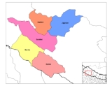
Bheri Zone is divided into five districts:
Bheri Anchal ' onMouseout='HidePop("50181")' href="/topics/Zones_of_Nepal">anchal or zone
Zones of Nepal
Nepal is divided into 14 administrative zones , and 75 districts . The 14 administrative zones are grouped into five development regions...
(first-order administrative district) in the Mid-Western
Mid-Western Region, Nepal
Mid-Western Region is one of Nepal's five development regions. Westward from the Central region surrounding Kathmandu are the Western, Mid-Western and finally Far-Western regions. Counter-intuitively, Mid-Western lies west of Western....
Development Region
Regions of Nepal
Nepal is divided into 14 administrative zones , which are divided into 75 districts . The 14 administrative zones are grouped into five development regions...
of Nepal
Nepal
Nepal , officially the Federal Democratic Republic of Nepal, is a landlocked sovereign state located in South Asia. It is located in the Himalayas and bordered to the north by the People's Republic of China, and to the south, east, and west by the Republic of India...
. Nepalgunj
Nepalgunj
Nepalgunj , also spelled Nepalganj, is a municipality in Banke District, Nepal on the Terai plains near the southern border with Bahraich district, Uttar Pradesh state of India. It is 16 km south of Kohalpur and the east-west Mahendra Highway....
is the administrative headquarters.
Cities and towns are Narayan
Narayan, Nepal
Narayan is a town and municipality in Dailekh District of Bheri Zone of western-central Nepal.-External links:*...
, Jajarkot
Jajarkot
Jajarkot is the capital city of Jajarkot District in Bheri Zone, Nepal. It is located at an altitude of 799 metres....
and Chhinchu
Chhinchu
Chhinchu is a village development committee in Surkhet District in the Bheri Zone of mid-western Nepal. At the time of the 1991 Nepal census it had a population of 6359 people living in 1436 individual households.-External links:*...
in the "hills"; Nepalgunj
Nepalgunj
Nepalgunj , also spelled Nepalganj, is a municipality in Banke District, Nepal on the Terai plains near the southern border with Bahraich district, Uttar Pradesh state of India. It is 16 km south of Kohalpur and the east-west Mahendra Highway....
, Gularia
Gularia
Gularia is a town and capital of Bardiya District in the Bheri Zone of south-western Nepal. At the time of the 1991 Nepal census it had a population of 14,999 and had 2,418 houses in the town.It lies at an elevation of 187 metres....
and Kohalpur
Kohalpur
Kohalpur is a town in Banke District in the Bheri Zone in mid-western Nepal. The town is in East-West highway and one of the fastest developing places in Nepal. A neighboring city Nepalgunj is on South , and further 6 km is the Indian border. In fact it is a growing city in the western...
in Terai
Terai
The Terai is a belt of marshy grasslands, savannas, and forests located south of the outer foothills of the Himalaya, the Siwalik Hills, and north of the Indo-Gangetic Plain of the Ganges, Brahmaputra and their tributaries. The Terai belongs to the Terai-Duar savanna and grasslands ecoregion...
; Birendranagar
Birendranagar
Birendranagar is a city in mid western Nepal, located in the Surkhet District of Bheri Zone. At the time of the 1991 Nepal census it had a population of 22,937 people residing in 4773 individual households....
in Surkhet Valley in the Inner Terai
Inner Terai Valleys of Nepal
The Inner Terai Valleys or Bhitri tarai are various elongated valleys in Nepal situated between the Himalayan foothills, the 600–900 m high Siwalik or Churia Range and the 2,000-3,000 m high Mahabharat Range further north. Major examples are the Chitwan Valley southwest of Kathmandu and the...
.
Bheri Zone is divided into five districts:
| District | Headquarters |
|---|---|
| Banke District Banke District -Geography:Banke is bordered on the west by Bardiya district. Rapti zone's Salyan and Dang Deukhuri Districts border to the north and east. To the south lies Uttar Pradesh, India; specifically Shravasti and Bahraich districts of Awadh. East of Nepalganj the international border follows the... |
Nepalgunj Nepalgunj Nepalgunj , also spelled Nepalganj, is a municipality in Banke District, Nepal on the Terai plains near the southern border with Bahraich district, Uttar Pradesh state of India. It is 16 km south of Kohalpur and the east-west Mahendra Highway.... |
| Bardiya District Bardiya District Bardiya DistrictBardiya DistrictBardiya DistrictBardiya DistrictBardiya DistrictBardiya DistrictBardiya DistrictBardiya DistrictBardiya District' onMouseout='HidePop("13378")' href="/topics/Gularia">Gularia Gularia Gularia is a town and capital of Bardiya District in the Bheri Zone of south-western Nepal. At the time of the 1991 Nepal census it had a population of 14,999 and had 2,418 houses in the town.It lies at an elevation of 187 metres.... |
|
| Dailekh District Dailekh District -Village Development Committees :*Awal Parajul*Bada Bhairab*Bada Khola*Badalamji*Baluwatar*Bansi*Baraha*Basantamala*Belaspur*Belpata*Bhawani*Bindhyabasini*Bisalla*Chamunda*Chauratha*Dada Parajul*Dullu*Gamaudi*Gauri*Goganpani*Jaganath... |
Khalanga Khalanga Khalanga is capital of Dailekh District in Bheri Zone, Nepal. The mountain town was the scene of a conflict between government forces and Maoist rebels. It is located at 29.13N 80.35.... |
| Jajarkot District Jajarkot District Jajarkot District of 134,868.Jajarkotis one of the district of Bheri Zone in Mid-western Region of Nepal. Khalanga is its headquarter... |
Jajarkot Jajarkot Jajarkot is the capital city of Jajarkot District in Bheri Zone, Nepal. It is located at an altitude of 799 metres.... |
| Surkhet District Surkhet District -Village Development Committees :*Agragaun*Awalaching*Babiyachaur*Bajedichaur*Betan*Bidyapur*Bijaura*Birendranagar*Chapre*Chhinchu*Dahachaur*Dandakhali*Dasarathpur*Dharapani*Gadi... |
Birendranagar Birendranagar Birendranagar is a city in mid western Nepal, located in the Surkhet District of Bheri Zone. At the time of the 1991 Nepal census it had a population of 22,937 people residing in 4773 individual households.... |
See also
- Zones of NepalZones of NepalNepal is divided into 14 administrative zones , and 75 districts . The 14 administrative zones are grouped into five development regions...
- Regions of NepalRegions of NepalNepal is divided into 14 administrative zones , which are divided into 75 districts . The 14 administrative zones are grouped into five development regions...
- Districts of NepalDistricts of NepalNepal's 14 administrative zones are subdivided into 75 districts . These districts are listed below, by zone...