
BBC Weather
Encyclopedia
BBC Weather is the BBC
's department in charge of preparing and broadcasting weather forecasts and is now part of BBC News
. The broadcast meteorologists are employed by the Met Office
. The longest-serving BBC weather forecaster is Michael Fish, who has currently appeared for 36 years between 1974 and 2010 (still occasionally forecasts for South East Today).
broadcast on the radio on behalf of the Met Office
on 14 November 1922, and the first daily weather forecast was broadcast on 26 March 1923.
In 1936, the BBC experimented with the world's first televised weather map
s, which was brought into practice in 1949 after World War II
. The map filled the entire screen, with an off-screen narrator commenting on the next day's weather.
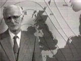
. In an in-vision the narrator stands in front of the map. At that point, the maps were drawn by hand in the London Weather Centre, before being couriered across London. The forecasts were presented by the same person who had composed them, and had relatively low accuracy. The London Weather Centre which opened in 1959 took the responsibility for the national radio weather broadcasts. Radio forecasters were chosen by a BBC audition from the forecasters at the London Weather Centre.
In 1962, the installation of a fax machine and an electronic computer in the Met Office led to more accurate and quicker forecasting.
Satellite photography was available from 1964, but was of a poor quality and was given on paper, with the coastline etched in felt-tip pen. This didn't change until 1973 with the installation of a new computer, increasing processing power of the Weather Centre greatly, leading to forecasts twice as accurate as earlier ones.
technology, each of which allowed the presenter greater control over the information displayed.
Early magnetic symbols tended to adhere poorly to the maps, and occasional spelling errors (such as the presenter writing 'GOF' instead of 'FOG') marred some broadcasts, but allowed the presenter to show how weather would change over time. The symbols were designed to be 'self-explicit', allowing the viewer to understand the map without a key or legend.
These were phased out in 1985 for computer graphics, although the basic design of symbols was kept the same. These forecasts were widely-acclaimed for their simplicity, winning an award from the Royal Television Society
in 1993.
On 2 October 2000 BBC Weather underwent a more significant change. Whilst there was not much change to the existing weather symbols new symbols giving information Pollen and Sun levels were introduced. A new more detailed map of Britain was used based on satellite data.
. Famous for his informal manner and eccentric dress sense (he once wore a blue and green blazer emblazoned with all the weather symbols), he was a viewer favourite despite an unfortunate comment before the Great Storm of 1987
.
During a weather forecast some hours before the storm, Michael Fish started his forecast with the now infamous line "Earlier on today, apparently, a woman rang the BBC and said she heard there was a hurricane on the way. Well, if you're watching, don't worry, there isn't". Although he was actually referring to a Florida hurricane (Floyd
), and went on to forecast stormy conditions over the South of England, the statement has gone down in popular culture as one of the worst mistakes made so publicly.
is indicated by the brightness of the map, while rain
and snow
are indicated by animated blue and white areas respectively.
The graphics are provided by Weatherscape XT, which was developed by the commercial arm of the New Zealand Metservice.
The move polarised opinion; some saw it as more accurate and modern, while others disliked the brown colour chosen for the landmass and the presumed high cost of the graphics. The angling of the map, in order to show the curvature of the Earth, led to Scotland
appearing little larger than Devon
, and Shetland being almost invisible while exaggerating London
and the South East
. This led to many Scottish commentators accusing the BBC of having a London bias
. As a result, the map was realigned, and the moving tour of the UK was lengthened. The previous graphics however, from 2000–05, did appear geographically more accurate when compared with a satellite image.
The new look won a prestigious Silver Award at the Promax/BDA Awards in 2006. Criticism has continued, however, with some viewers complaining about the colour scheme, and of a lack of detail beyond 36 hours.
There have been continuous developments since May 2005. In 2006, a rippling effect was introduced to define seas and oceans.
The website also runs frequent special features about seasonal sports, white Christmas
, nature and meteorological science. It also has world weather, UK outlook and weather news.
BBC
The British Broadcasting Corporation is a British public service broadcaster. Its headquarters is at Broadcasting House in the City of Westminster, London. It is the largest broadcaster in the world, with about 23,000 staff...
's department in charge of preparing and broadcasting weather forecasts and is now part of BBC News
BBC News
BBC News is the department of the British Broadcasting Corporation responsible for the gathering and broadcasting of news and current affairs. The department is the world's largest broadcast news organisation and generates about 120 hours of radio and television output each day, as well as online...
. The broadcast meteorologists are employed by the Met Office
Met Office
The Met Office , is the United Kingdom's national weather service, and a trading fund of the Department for Business, Innovation and Skills...
. The longest-serving BBC weather forecaster is Michael Fish, who has currently appeared for 36 years between 1974 and 2010 (still occasionally forecasts for South East Today).
Early history
The first BBC weather forecast was a shipping forecastShipping Forecast
The Shipping Forecast is a four-times-daily BBC Radio broadcast of weather reports and forecasts for the seas around the coasts of the British Isles. It is produced by the Met Office and broadcast by BBC Radio 4 on behalf of the Maritime and Coastguard Agency. The forecasts sent over the Navtex...
broadcast on the radio on behalf of the Met Office
Met Office
The Met Office , is the United Kingdom's national weather service, and a trading fund of the Department for Business, Innovation and Skills...
on 14 November 1922, and the first daily weather forecast was broadcast on 26 March 1923.
In 1936, the BBC experimented with the world's first televised weather map
Weather map
A weather map displays various meteorological features across a particular area at a particular point in time. Such maps have been in use since the mid-19th century and are used for research and weather forecasting purposes. Maps using isotherms show temperature gradients, which can help locate...
s, which was brought into practice in 1949 after World War II
World War II
World War II, or the Second World War , was a global conflict lasting from 1939 to 1945, involving most of the world's nations—including all of the great powers—eventually forming two opposing military alliances: the Allies and the Axis...
. The map filled the entire screen, with an off-screen narrator commenting on the next day's weather.
Advancement of technology
On 11 January 1954, the first in-vision weather forecast was broadcast, presented by George CowlingGeorge Cowling
George Cowling was the BBC's first television weatherman. Cowling joined the Met Office in 1939 and worked as a forecaster for the RAF before joining the BBC in 1954. On 11 January 1954, he gave the first televised weather broadcast. He continued to present televised weather broadcasts for the BBC...
. In an in-vision the narrator stands in front of the map. At that point, the maps were drawn by hand in the London Weather Centre, before being couriered across London. The forecasts were presented by the same person who had composed them, and had relatively low accuracy. The London Weather Centre which opened in 1959 took the responsibility for the national radio weather broadcasts. Radio forecasters were chosen by a BBC audition from the forecasters at the London Weather Centre.
In 1962, the installation of a fax machine and an electronic computer in the Met Office led to more accurate and quicker forecasting.
Satellite photography was available from 1964, but was of a poor quality and was given on paper, with the coastline etched in felt-tip pen. This didn't change until 1973 with the installation of a new computer, increasing processing power of the Weather Centre greatly, leading to forecasts twice as accurate as earlier ones.
Graphical technology
As computational capability improved, so did graphics technology. Early hand-drawn maps gave way to magnetic symbols, which in turn gave way to bluescreen (CSO) computer-generated imageryComputer-generated imagery
Computer-generated imagery is the application of the field of computer graphics or, more specifically, 3D computer graphics to special effects in art, video games, films, television programs, commercials, simulators and simulation generally, and printed media...
technology, each of which allowed the presenter greater control over the information displayed.
Early magnetic symbols tended to adhere poorly to the maps, and occasional spelling errors (such as the presenter writing 'GOF' instead of 'FOG') marred some broadcasts, but allowed the presenter to show how weather would change over time. The symbols were designed to be 'self-explicit', allowing the viewer to understand the map without a key or legend.
These were phased out in 1985 for computer graphics, although the basic design of symbols was kept the same. These forecasts were widely-acclaimed for their simplicity, winning an award from the Royal Television Society
Royal Television Society
The Royal Television Society is a British-based educational charity for the discussion, and analysis of television in all its forms, past, present and future. It is the oldest television society in the world...
in 1993.
On 2 October 2000 BBC Weather underwent a more significant change. Whilst there was not much change to the existing weather symbols new symbols giving information Pollen and Sun levels were introduced. A new more detailed map of Britain was used based on satellite data.
Great Storm of 1987 controversy
Possibly the most famous of the forecasters is the now semi-retired Michael FishMichael Fish
Michael Fish MBE is a semi-retired British weather forecaster, best known for his BBC Weather television presentations, although he was actually employed by the Met Office....
. Famous for his informal manner and eccentric dress sense (he once wore a blue and green blazer emblazoned with all the weather symbols), he was a viewer favourite despite an unfortunate comment before the Great Storm of 1987
Great Storm of 1987
The Great Storm of 1987 occurred on the night of 15/16 October 1987, when an unusually strong weather system caused winds to hit much of southern England and northern France...
.
During a weather forecast some hours before the storm, Michael Fish started his forecast with the now infamous line "Earlier on today, apparently, a woman rang the BBC and said she heard there was a hurricane on the way. Well, if you're watching, don't worry, there isn't". Although he was actually referring to a Florida hurricane (Floyd
Hurricane Floyd (1987)
Hurricane Floyd was the only hurricane to make landfall in the United States in the 1987 Atlantic hurricane season. The final of seven tropical storms and three hurricanes, Floyd developed on October 9 just off the east coast of Nicaragua. After becoming a tropical storm, it moved northward...
), and went on to forecast stormy conditions over the South of England, the statement has gone down in popular culture as one of the worst mistakes made so publicly.
Today
The weather symbols were replaced in May 2005 after 29 years and 9 months on air by a controversial format as the forecast underwent another redesign, with the flat map replaced by a 3D globe, and weather conditions shown by coloured areas. Cloud coverCloud cover
Cloud cover refers to the fraction of the sky obscured by clouds when observed from a particular location...
is indicated by the brightness of the map, while rain
Rain
Rain is liquid precipitation, as opposed to non-liquid kinds of precipitation such as snow, hail and sleet. Rain requires the presence of a thick layer of the atmosphere to have temperatures above the melting point of water near and above the Earth's surface...
and snow
Snow
Snow is a form of precipitation within the Earth's atmosphere in the form of crystalline water ice, consisting of a multitude of snowflakes that fall from clouds. Since snow is composed of small ice particles, it is a granular material. It has an open and therefore soft structure, unless packed by...
are indicated by animated blue and white areas respectively.
The graphics are provided by Weatherscape XT, which was developed by the commercial arm of the New Zealand Metservice.
The move polarised opinion; some saw it as more accurate and modern, while others disliked the brown colour chosen for the landmass and the presumed high cost of the graphics. The angling of the map, in order to show the curvature of the Earth, led to Scotland
Scotland
Scotland is a country that is part of the United Kingdom. Occupying the northern third of the island of Great Britain, it shares a border with England to the south and is bounded by the North Sea to the east, the Atlantic Ocean to the north and west, and the North Channel and Irish Sea to the...
appearing little larger than Devon
Devon
Devon is a large county in southwestern England. The county is sometimes referred to as Devonshire, although the term is rarely used inside the county itself as the county has never been officially "shired", it often indicates a traditional or historical context.The county shares borders with...
, and Shetland being almost invisible while exaggerating London
London
London is the capital city of :England and the :United Kingdom, the largest metropolitan area in the United Kingdom, and the largest urban zone in the European Union by most measures. Located on the River Thames, London has been a major settlement for two millennia, its history going back to its...
and the South East
South East England
South East England is one of the nine official regions of England, designated in 1994 and adopted for statistical purposes in 1999. It consists of Berkshire, Buckinghamshire, East Sussex, Hampshire, Isle of Wight, Kent, Oxfordshire, Surrey and West Sussex...
. This led to many Scottish commentators accusing the BBC of having a London bias
North-South divide in the United Kingdom
In England, the term North–South divide refers to the economic and cultural differences between Southern England and Northern England...
. As a result, the map was realigned, and the moving tour of the UK was lengthened. The previous graphics however, from 2000–05, did appear geographically more accurate when compared with a satellite image.
The new look won a prestigious Silver Award at the Promax/BDA Awards in 2006. Criticism has continued, however, with some viewers complaining about the colour scheme, and of a lack of detail beyond 36 hours.
There have been continuous developments since May 2005. In 2006, a rippling effect was introduced to define seas and oceans.
Online forecasts
The BBC Weather website provides outlook weather forecasts for UK and international locations using animated symbols and a format similar in design to that used for the televised broadcasts. The website was open and launched back in 1997.The website also runs frequent special features about seasonal sports, white Christmas
White Christmas
A white Christmas refers to the presence of snow on Christmas Day. This phenomenon is most common in the northern countries of the Northern Hemisphere...
, nature and meteorological science. It also has world weather, UK outlook and weather news.
See also
- National, regional and retired BBC weather forecasters
Further reading
- Hunt, Roger, "The end of weather forecasting at Met Office London", Weather magazine, Royal Meteorological SocietyRoyal Meteorological SocietyThe Royal Meteorological Society traces its origins back to 3 April 1850 when the British Meteorological Society was formed as a society the objects of which should be the advancement and extension of meteorological science by determining the laws of climate and of meteorological phenomena in general...
, June 2007, v.62, no.6, pp. 143–146