

Aston by Wrenbury
Encyclopedia
Newhall, Cheshire
Newhall is a village and civil parish in the unitary authority of Cheshire East and the ceremonial county of Cheshire, England. The village lies 3½ miles to the west of Audlem and 5 miles to the south west of Nantwich...
in the unitary authority of Cheshire East
Cheshire East
Cheshire East is a unitary authority area with borough status in the ceremonial county of Cheshire, England.The borough was established in April 2009 as part of the 2009 structural changes to local government in England, by virtue of an order under the Local Government and Public Involvement in...
and the ceremonial county of Cheshire
Cheshire
Cheshire is a ceremonial county in North West England. Cheshire's county town is the city of Chester, although its largest town is Warrington. Other major towns include Widnes, Congleton, Crewe, Ellesmere Port, Runcorn, Macclesfield, Winsford, Northwich, and Wilmslow...
, England
England
England is a country that is part of the United Kingdom. It shares land borders with Scotland to the north and Wales to the west; the Irish Sea is to the north west, the Celtic Sea to the south west, with the North Sea to the east and the English Channel to the south separating it from continental...
.
The village should not be confused with several other villages named Aston in Cheshire, which include Aston juxta Mondrum
Aston juxta Mondrum
Aston juxta Mondrum is a village and civil parish in the unitary authority of Cheshire East and the ceremonial county of Cheshire, England. It is about four miles north of Nantwich. The civil parish also includes part of Worleston village.-History:...
, Aston by Budworth
Aston by Budworth
Aston by Budworth is a civil parish in the unitary authority of Cheshire East and the ceremonial county of Cheshire, England. The main villages in the parish are Arley, which is the site of Arley Hall, and Bate Green. According to the 2001 census the parish had a population of 281.-External links:...
and Aston, Vale Royal
Aston, Vale Royal
right|thumb|200px|Map of civil parish of Aston within the former borough of Vale RoyalAston is a village and civil parish in the unitary authority of Cheshire West and Chester and the ceremonial county of Cheshire, England. According to the 2001 census it had a population of 111...
.
History
Domesday Book
Domesday Book , now held at The National Archives, Kew, Richmond upon Thames in South West London, is the record of the great survey of much of England and parts of Wales completed in 1086...
as Estune, meaning eastern manor, settlement or farmstead.
Geography and transport
Aston lies between the larger villages of WrenburyWrenbury
Wrenbury is a village in the civil parish of Wrenbury cum Frith, the unitary authority of Cheshire East, and the ceremonial county of Cheshire, England...
(1¼ miles north west) and Audlem
Audlem
Audlem is a large village and civil parish located in the unitary authority of Cheshire East and the ceremonial county of Cheshire in the north west of England, approximately south of Nantwich. Close to the border with the neighbouring county of Shropshire, the village is eight miles east of...
(3¾ miles south east), with Nantwich
Nantwich
Nantwich is a market town and civil parish in the Borough of Cheshire East and the ceremonial county of Cheshire, England. The town gives its name to the parliamentary constituency of Crewe and Nantwich...
being 4¼ miles to the north east. The main part of the village is located on Wrenbury Road north west of the A530
A530 road
The A530 road is a road linking the A525 east of Whitchurch, Shropshire, England with the A559 east of Northwich, in Cheshire. The road follows the route:*A525*Nantwich*Crewe*Middlewich*A559...
; the southern part lies along Sheppenhall Lane south of the A530. The Cheshire Cycleway and South Cheshire Way
South Cheshire Way
The South Cheshire Way is a long-distance footpath running east–west mainly through Cheshire, England, though parts lie in Shropshire and Staffordshire. The western section from Grindley Brook, near Whitchurch, runs through farmland; the eastern section from Mow Cop, near Biddulph, runs through...
long-distance path run through the village, and the Welsh Marches railway line
Welsh Marches Line
The Welsh Marches Line , known historically as the North and West Route, is the railway line running from Newport in south-east Wales to Shrewsbury in the West Midlands region of England by way of Abergavenny, Hereford and Craven Arms, and thence to Crewe via Whitchurch...
runs ½ mile to the north west.
Landmarks
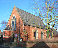
Features of interest include the red-brick St Andrew's Methodist Church (1866), which has an associated Grade II listed lychgateLychgate
A lychgate, also spelled lichgate, lycugate, or as two separate words lych gate, is a gateway covered with a roof found at the entrance to a traditional English or English-style churchyard.-Name:...
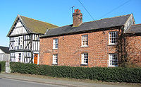
and war memorial dating from around 1919 leading to a small cemetery. Aston House Farm is a Grade II listed, black-and-white timber farmhouse, dating from 1662. The village also has a Grade II listed red telephone box
Red telephone box
The red telephone box, a public telephone kiosk designed by Sir Giles Gilbert Scott, is a familiar sight on the streets of the United Kingdom, Malta, Bermuda and Gibraltar, and despite a reduction in their numbers in recent years, red boxes can still be seen in many places and in current or former...
, an example of the 1935 K6 style designed by Sir Giles Gilbert Scott
Giles Gilbert Scott
Sir Giles Gilbert Scott, OM, FRIBA was an English architect known for his work on such buildings as Liverpool Cathedral and Battersea Power Station and designing the iconic red telephone box....
.
Aston Mill is an animal feed mill run by H J Lea Oakes Ltd, one of the few large industrial enterprises in this predominantly agricultural area.
Connections with India
The Bhurtpore Inn in the north of the village dates from 1720 and was first recorded as a public house in 1778. It was named to commemorate the Siege of BhurtporeBharatpur, India
Bharatpur is a city in the Indian state of Rajasthan. It was founded by Maharaja Suraj Mal in 1733. Located in the Brij region, Bharatpur was once an impregnable, well-planned and well-fortified city, and the capital of Jat kingdom ruled by Sinsinwar Maharajas.The trio of Bharatpur, Deeg and...
of 1825-6, at which local landlord Sir Stapleton Cotton
Stapleton Cotton, 1st Viscount Combermere
Field Marshal Stapleton Cotton, 1st Viscount Combermere GCB, GCH, KSI, PC , was a British military leader, diplomat and politician...
, as Commander-in-Chief of the British forces, took the fort after a prolonged siege, earning the title of Viscount Combermere. The present Bhurtpore Inn, an untied hostelry serving a selection of real ales and curries, has won several awards, including The Good Pub Guides National Beer Pub of the Year in 1997 and 1999, and CAMRA
Campaign for Real Ale
The Campaign for Real Ale is an independent voluntary consumer organisation based in St Albans, England, whose main aims are promoting real ale, real cider and the traditional British pub...
's Regional Pub of the Year 2005.