
Ashley Down
Encyclopedia
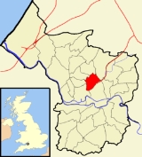
Ashley is one of thirty-five council wards
in the city of Bristol
in the United Kingdom
. The ward contains the areas of Ashley Down, Baptist Mills, Montpelier, St Andrew's, St Paul's and St Werburghs.
parliamentary constituency, which elects one Member of Parliament. The incumbent Member of Parliament is Stephen Williams
MP, a Liberal Democrat.
On Bristol City Council, Ashley sends two councillors. Currently, these are Cllr Dr Jon Rogers, a liberal democrat, and Cllr Gus Hoyt of the Green party. Cllr Hoyt was elected in May 2011, following Cllr Rogers' re-election in 2009.
, Horfield
and St Werburghs
. The main artery is the Ashley Down Road. Ashley Down is the home of the City of Bristol College
, Brunel Campus, once the Muller Homes orphanage
, built between 1845 and 1849.
It is also the location of the Gloucestershire County Cricket ground
.
. It was home to a brass
works between 1700 and 1840, and a pottery
between 1840 and 1891. The area is now often regarded as part of St Werburghs. In the 19th Century part of Baptist Mills was also known as Botany Bay and regarded as a fairly lawless area.
 Montpelier is an area of North Bristol
. It is bounded by the Cheltenham Road to the west, St Paul's to the south, St Werburghs to the east and St Andrew's to the north. It has its own railway station
, and a reputation for being bohemian
and 'alternative'. Picton Street is a haven for lovers of organic and vegetarian cuisine.
Picton Street was built and named in honour of Sir Thomas Picton who, as Captain Picton, in 1783 endeared himself to Bristolians by bravely facing the rebellious 75th Battalion on College Green and averting a military mutiny. There is also a double-bayed villa in the street named after him, Picton Lodge.
situated about 3 km (1.9 mi) north of the city centre. The area was developed in the late 19th century as St Andrew's Park Estate, and consists mostly of large Victorian villa
s, with some inter-war housing and some rebuilding following enemy action in World War II
.
The area is roughly bounded by the Severn Beach Railway Line
, Gloucester Rd and Sommerville Rd; however as is often the case the boundary is debatable: According to the Ordnance Survey
map this area is Montpelier, whereas according to the National Gazetteer of 1868 Montpelier is a hamlet within the Parish of St Andrew's. St Andrew's church, which gave the area its name, was in St Andrew's Road, Montpelier. It was demolished in 1969.
In the middle part of the 20th century the area became unfashionable and many of the houses were converted to multiple occupation. However during the 1990s living in the City Centre
became fashionable once again and consequently these houses are now being converted back into family homes, their owners once again taking pride in them and restoring their period features.
St Andrew's is well-served by public transport
, with frequent buses to all parts of the city from Gloucester road, buses to UWE's Frenchay Campus and a local train service from Montpelier Station
to Bristol Temple Meads, Clifton
, Avonmouth
and Severn Beach
.
Most of the events and input on the parks organisation is overseen by the voluntary organisation Friends of St Andrews Park
The park features a well-sized children's play area (extended and refurbished in 2010), permanent paddling pool (serviced and used only in the summer months), tea rooms (open in summer and during special events) and public toilets (limited opening hours). Despite being located on a hilly incline, the park is well used for football and frisbee
throughout the year, as well as juggling, stilt walking, tightrope walking and other circus skills.
On April 30th 1941 a Wellington bomber on a night training flight crashed in the park after hitting balloon barrage cables. There is now a memorial to the crash in the park. See www.wellingtont2905.co.uk
of Bristol
, England
, situated just north east of the city
centre and west of the M32
. In the early 18th century it was laid out as one of Bristol's first suburbs.
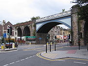
St. Werburghs is an area in central north-east Bristol
, England
. Surrounded by the M32 motorway
, railway embankments and allotment
slopes it has the feel of a green village in the inner city.
The area became known as St.Werburghs when St Werburgh's Church was relocated (and substantially rebuilt) to Mina Road in this district from Corn Street, Bristol in 1879. Before then the northern part was Ashley Vale and the southern part Baptist Mills.
It is now a Climbing
Centre by Undercover Rock and the St Werburghs city farm
.
Wards of the United Kingdom
A ward in the United Kingdom is an electoral district at sub-national level represented by one or more councillors. It is the primary unit of British administrative and electoral geography .-England:...
in the city of Bristol
Bristol
Bristol is a city, unitary authority area and ceremonial county in South West England, with an estimated population of 433,100 for the unitary authority in 2009, and a surrounding Larger Urban Zone with an estimated 1,070,000 residents in 2007...
in the United Kingdom
United Kingdom
The United Kingdom of Great Britain and Northern IrelandIn the United Kingdom and Dependencies, other languages have been officially recognised as legitimate autochthonous languages under the European Charter for Regional or Minority Languages...
. The ward contains the areas of Ashley Down, Baptist Mills, Montpelier, St Andrew's, St Paul's and St Werburghs.
Politics
Ashley is part of the Bristol WestBristol West
Bristol West is a borough constituency represented in the House of Commons of the Parliament of the United Kingdom. It covers the central and western parts of Bristol.-Boundaries:...
parliamentary constituency, which elects one Member of Parliament. The incumbent Member of Parliament is Stephen Williams
Stephen Williams (politician)
Stephen Roy Williams is a British Liberal Democrat politician who was first elected as the Member of Parliament for Bristol West in the 2005 general election, being re-elected with an increased majority in May 2010...
MP, a Liberal Democrat.
On Bristol City Council, Ashley sends two councillors. Currently, these are Cllr Dr Jon Rogers, a liberal democrat, and Cllr Gus Hoyt of the Green party. Cllr Hoyt was elected in May 2011, following Cllr Rogers' re-election in 2009.
Ashley Down
Ashley Down is an area sandwiched between BishopstonBishopston, Bristol
Bishopston the name of both a council ward of the city of Bristol, England, and a suburb of the city that falls within that ward. Bishopston is situated around the Gloucester Road , the main northern arterial road in the city. The ward includes St Bonaventures and Ashley Down parishes, as well as...
, Horfield
Horfield
Horfield is a suburb of the city of Bristol, in southwest England. It lies on Bristol's northern edge, its border with Filton marking part of the boundary between Bristol and South Gloucestershire. Bishopston lies directly to the south. Monks Park and Golden Hill are to the west. Lockleaze and...
and St Werburghs
St Werburghs, Bristol
St. Werburghs is an area in central north-east Bristol, England. Surrounded by the M32 motorway, railway embankments and allotment slopes it has the feel of a green village in the inner city.- History :...
. The main artery is the Ashley Down Road. Ashley Down is the home of the City of Bristol College
City of Bristol College
City of Bristol College is one of the largest further education colleges in the UK. Based in Bristol, the College continues to gain national recognition for its work with adults, young people and employers.- Awards :* LSIS Beacon status...
, Brunel Campus, once the Muller Homes orphanage
New Orphan Houses, Ashley Down, Bristol
The New Orphan Houses, Ashley Down, commonly known as the Muller Homes, were an orphanage in the district of Ashley Down, in the north of Bristol. They were built between 1849 and 1870 by the Prussian evangelist George Müller to show the world that God not only heard, but answered, prayer...
, built between 1845 and 1849.
It is also the location of the Gloucestershire County Cricket ground
County Cricket Ground, Bristol
The County Cricket Ground is a cricket venue in Bristol, England. It is in the district of Ashley Down. The ground is home to the Gloucestershire County Cricket Club....
.
Baptist Mills
Baptist Mills is a small area, which is located between St Werburghs and EastonEaston, Bristol
Easton is both the name of a council ward in the city of Bristol in the United Kingdom, and an inner city area that lies partly within that ward. The Easton ward also contains the Whitehall and Netham areas of the city. Notable places within the ward include Lawrence Hill and Stapleton Road railway...
. It was home to a brass
Brass
Brass is an alloy of copper and zinc; the proportions of zinc and copper can be varied to create a range of brasses with varying properties.In comparison, bronze is principally an alloy of copper and tin...
works between 1700 and 1840, and a pottery
Pottery
Pottery is the material from which the potteryware is made, of which major types include earthenware, stoneware and porcelain. The place where such wares are made is also called a pottery . Pottery also refers to the art or craft of the potter or the manufacture of pottery...
between 1840 and 1891. The area is now often regarded as part of St Werburghs. In the 19th Century part of Baptist Mills was also known as Botany Bay and regarded as a fairly lawless area.
Montpelier
Bristol
Bristol is a city, unitary authority area and ceremonial county in South West England, with an estimated population of 433,100 for the unitary authority in 2009, and a surrounding Larger Urban Zone with an estimated 1,070,000 residents in 2007...
. It is bounded by the Cheltenham Road to the west, St Paul's to the south, St Werburghs to the east and St Andrew's to the north. It has its own railway station
Montpelier railway station
Montpelier railway station is located in Montpelier, Bristol, England. It is a single-platformed station, north-west of Bristol Temple Meads on the Severn Beach Line. The station is managed and the service is operated by First Great Western. It is next to Cromwell Road, Cromwell Road itself is...
, and a reputation for being bohemian
Bohemianism
Bohemianism is the practice of an unconventional lifestyle, often in the company of like-minded people, with few permanent ties, involving musical, artistic or literary pursuits...
and 'alternative'. Picton Street is a haven for lovers of organic and vegetarian cuisine.
Picton Street was built and named in honour of Sir Thomas Picton who, as Captain Picton, in 1783 endeared himself to Bristolians by bravely facing the rebellious 75th Battalion on College Green and averting a military mutiny. There is also a double-bayed villa in the street named after him, Picton Lodge.
St Andrew's
St Andrew's is a suburb of BristolBristol
Bristol is a city, unitary authority area and ceremonial county in South West England, with an estimated population of 433,100 for the unitary authority in 2009, and a surrounding Larger Urban Zone with an estimated 1,070,000 residents in 2007...
situated about 3 km (1.9 mi) north of the city centre. The area was developed in the late 19th century as St Andrew's Park Estate, and consists mostly of large Victorian villa
Victorian architecture
The term Victorian architecture refers collectively to several architectural styles employed predominantly during the middle and late 19th century. The period that it indicates may slightly overlap the actual reign, 20 June 1837 – 22 January 1901, of Queen Victoria. This represents the British and...
s, with some inter-war housing and some rebuilding following enemy action in World War II
World War II
World War II, or the Second World War , was a global conflict lasting from 1939 to 1945, involving most of the world's nations—including all of the great powers—eventually forming two opposing military alliances: the Allies and the Axis...
.
The area is roughly bounded by the Severn Beach Railway Line
Severn Beach Line
The Severn Beach Line is a local railway in Bristol, UK. It runs from Narroways Hill Junction to Severn Beach, and is the successor to the Bristol Port Railway and Pier, which ran from a Bristol terminus in the Avon Gorge to a station and pier on the Severn Estuary.Passenger trains run from Bristol...
, Gloucester Rd and Sommerville Rd; however as is often the case the boundary is debatable: According to the Ordnance Survey
Ordnance Survey
Ordnance Survey , an executive agency and non-ministerial government department of the Government of the United Kingdom, is the national mapping agency for Great Britain, producing maps of Great Britain , and one of the world's largest producers of maps.The name reflects its creation together with...
map this area is Montpelier, whereas according to the National Gazetteer of 1868 Montpelier is a hamlet within the Parish of St Andrew's. St Andrew's church, which gave the area its name, was in St Andrew's Road, Montpelier. It was demolished in 1969.
In the middle part of the 20th century the area became unfashionable and many of the houses were converted to multiple occupation. However during the 1990s living in the City Centre
Bristol
Bristol is a city, unitary authority area and ceremonial county in South West England, with an estimated population of 433,100 for the unitary authority in 2009, and a surrounding Larger Urban Zone with an estimated 1,070,000 residents in 2007...
became fashionable once again and consequently these houses are now being converted back into family homes, their owners once again taking pride in them and restoring their period features.
St Andrew's is well-served by public transport
Public transport in Bristol
The majority of public transport users in the Bristol Urban Area are transported by bus, although rail has experienced growth and does play an important part, particularly in peak hours...
, with frequent buses to all parts of the city from Gloucester road, buses to UWE's Frenchay Campus and a local train service from Montpelier Station
Montpelier railway station
Montpelier railway station is located in Montpelier, Bristol, England. It is a single-platformed station, north-west of Bristol Temple Meads on the Severn Beach Line. The station is managed and the service is operated by First Great Western. It is next to Cromwell Road, Cromwell Road itself is...
to Bristol Temple Meads, Clifton
Clifton Down railway station
Clifton Down railway station is located on Whiteladies Road in Clifton, Bristol, England. The station is west of Bristol Temple Meads on the Severn Beach Line...
, Avonmouth
Avonmouth railway station
Avonmouth railway station is a railway station serving the suburb of Avonmouth in Bristol, north-west from Bristol Temple Meads on the Severn Beach Line. All trains serving it are operated and the station is managed by First Great Western. The station is managed by First Great Western.Five...
and Severn Beach
Severn Beach railway station
Severn Beach railway station serves the village of Severn Beach, England. This is the terminus of the Severn Beach Line.This station is north west from Bristol Temple Meads on the Severn Beach Line...
.
St Andrew's Park
St Andrew's Park is at the heart of the area. The park was laid out in 1895, and is home to events such as 'Music in the Park' during the summer (although this event stopped in 2006 due to council regulation), and 'Carols in the Park' at Christmas.Most of the events and input on the parks organisation is overseen by the voluntary organisation Friends of St Andrews Park
The park features a well-sized children's play area (extended and refurbished in 2010), permanent paddling pool (serviced and used only in the summer months), tea rooms (open in summer and during special events) and public toilets (limited opening hours). Despite being located on a hilly incline, the park is well used for football and frisbee
Frisbee
A flying disc is a disc-shaped glider that is generally plastic and roughly in diameter, with a lip. The shape of the disc, an airfoil in cross-section, allows it to fly by generating lift as it moves through the air while rotating....
throughout the year, as well as juggling, stilt walking, tightrope walking and other circus skills.
On April 30th 1941 a Wellington bomber on a night training flight crashed in the park after hitting balloon barrage cables. There is now a memorial to the crash in the park. See www.wellingtont2905.co.uk
St Paul's
St Paul's is an inner suburbSuburb
The word suburb mostly refers to a residential area, either existing as part of a city or as a separate residential community within commuting distance of a city . Some suburbs have a degree of administrative autonomy, and most have lower population density than inner city neighborhoods...
of Bristol
Bristol
Bristol is a city, unitary authority area and ceremonial county in South West England, with an estimated population of 433,100 for the unitary authority in 2009, and a surrounding Larger Urban Zone with an estimated 1,070,000 residents in 2007...
, England
England
England is a country that is part of the United Kingdom. It shares land borders with Scotland to the north and Wales to the west; the Irish Sea is to the north west, the Celtic Sea to the south west, with the North Sea to the east and the English Channel to the south separating it from continental...
, situated just north east of the city
City
A city is a relatively large and permanent settlement. Although there is no agreement on how a city is distinguished from a town within general English language meanings, many cities have a particular administrative, legal, or historical status based on local law.For example, in the U.S...
centre and west of the M32
M32 motorway
The M32 is a motorway in South Gloucestershire and Bristol, England. It provides a link from Bristol city centre to the M4 and is part of the Bristol Parkway. At about , it is one of Britain's shortest motorways...
. In the early 18th century it was laid out as one of Bristol's first suburbs.
St Werburghs
St. Werburghs is an area in central north-east Bristol
Bristol
Bristol is a city, unitary authority area and ceremonial county in South West England, with an estimated population of 433,100 for the unitary authority in 2009, and a surrounding Larger Urban Zone with an estimated 1,070,000 residents in 2007...
, England
England
England is a country that is part of the United Kingdom. It shares land borders with Scotland to the north and Wales to the west; the Irish Sea is to the north west, the Celtic Sea to the south west, with the North Sea to the east and the English Channel to the south separating it from continental...
. Surrounded by the M32 motorway
M32 motorway
The M32 is a motorway in South Gloucestershire and Bristol, England. It provides a link from Bristol city centre to the M4 and is part of the Bristol Parkway. At about , it is one of Britain's shortest motorways...
, railway embankments and allotment
Allotment (gardening)
An allotment garden, often called simply an allotment, is a plot of land made available for individual, non-professional gardening. Such plots are formed by subdividing a piece of land into a few or up to several hundreds of land parcels that are assigned to individuals or families...
slopes it has the feel of a green village in the inner city.
The area became known as St.Werburghs when St Werburgh's Church was relocated (and substantially rebuilt) to Mina Road in this district from Corn Street, Bristol in 1879. Before then the northern part was Ashley Vale and the southern part Baptist Mills.
It is now a Climbing
Climbing
Climbing is the activity of using one's hands and feet to ascend a steep object. It is done both for recreation and professionally, as part of activities such as maintenance of a structure, or military operations.Climbing activities include:* Bouldering: Ascending boulders or small...
Centre by Undercover Rock and the St Werburghs city farm
City farm
City farms are usually community-run projects in urban areas, which involve people interacting and working with animals and plants. They aim to improve community relationships and offer an awareness of agriculture and farming to people who live in built-up areas.They vary in size from small plots...
.