
Arroyo Seco Creek
Encyclopedia
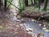
Arroyo Seco Creek or simply Arroyo Seco is a 6.9 miles (11.1 km) tributary
stream
to Schell Creek in southern Sonoma County, California
, United States
. In the Spanish language
arroyo seco means "dry creek".
Arroyo Seco Creek drains a portion of the western slopes of the southern Mayacamas Mountains. Its 11.4 square miles (30 km²) watershed, along with the entire Mayacmas mountain block, was formed in the Miocene
era by volcanic
action along with tectonic uplift about 12 million years ago.
Soils of the immediate streambed and its vicinity are classified as the Riverwash series, recent deposition of sands and gravels.
Arroyo Seco Creek springs near the Napa County
line about 4 mi (6 km) northeast of Sonoma, California
. It flows southward, emerging from the hills near Sonoma Valley Hospital. After a confluence with Haraszthy Creek, it crosses under State Route 12 near Schellville, California
, where it flows into Schell Creek. Schell Creek discharges to a network of sloughs which eventually empty into Sonoma Creek
, which in turn empties into the Napa Sonoma Marsh
and San Pablo Bay
.
Tributary
A tributary or affluent is a stream or river that flows into a main stem river or a lake. A tributary does not flow directly into a sea or ocean...
stream
Stream
A stream is a body of water with a current, confined within a bed and stream banks. Depending on its locale or certain characteristics, a stream may be referred to as a branch, brook, beck, burn, creek, "crick", gill , kill, lick, rill, river, syke, bayou, rivulet, streamage, wash, run or...
to Schell Creek in southern Sonoma County, California
Sonoma County, California
Sonoma County, located on the northern coast of the U.S. state of California, is the largest and northernmost of the nine San Francisco Bay Area counties. Its population at the 2010 census was 483,878. Its largest city and county seat is Santa Rosa....
, United States
United States
The United States of America is a federal constitutional republic comprising fifty states and a federal district...
. In the Spanish language
Spanish language
Spanish , also known as Castilian , is a Romance language in the Ibero-Romance group that evolved from several languages and dialects in central-northern Iberia around the 9th century and gradually spread with the expansion of the Kingdom of Castile into central and southern Iberia during the...
arroyo seco means "dry creek".
Arroyo Seco Creek drains a portion of the western slopes of the southern Mayacamas Mountains. Its 11.4 square miles (30 km²) watershed, along with the entire Mayacmas mountain block, was formed in the Miocene
Miocene
The Miocene is a geological epoch of the Neogene Period and extends from about . The Miocene was named by Sir Charles Lyell. Its name comes from the Greek words and and means "less recent" because it has 18% fewer modern sea invertebrates than the Pliocene. The Miocene follows the Oligocene...
era by volcanic
Volcano
2. Bedrock3. Conduit 4. Base5. Sill6. Dike7. Layers of ash emitted by the volcano8. Flank| 9. Layers of lava emitted by the volcano10. Throat11. Parasitic cone12. Lava flow13. Vent14. Crater15...
action along with tectonic uplift about 12 million years ago.
Soils of the immediate streambed and its vicinity are classified as the Riverwash series, recent deposition of sands and gravels.
Arroyo Seco Creek springs near the Napa County
Napa County, California
Napa County is a county located north of the San Francisco Bay Area in the U.S. state of California. It is coterminous with the Napa, California, Metropolitan Statistical Area. As of 2010 the population is 136,484. The county seat is Napa....
line about 4 mi (6 km) northeast of Sonoma, California
Sonoma, California
Sonoma is a historically significant city in Sonoma Valley, Sonoma County, California, USA, surrounding its historic town plaza, a remnant of the town's Mexican colonial past. It was the capital of the short-lived California Republic...
. It flows southward, emerging from the hills near Sonoma Valley Hospital. After a confluence with Haraszthy Creek, it crosses under State Route 12 near Schellville, California
Schellville, California
Schellville is an unincorporated community in Sonoma County, California, United States. Schellville is located at the junction of California State Route 12 and California State Route 121 south of Sonoma...
, where it flows into Schell Creek. Schell Creek discharges to a network of sloughs which eventually empty into Sonoma Creek
Sonoma Creek
Sonoma Creek is a stream in northern California. It is one of two principal drainages of southern Sonoma County, California, with headwaters rising in the rugged hills of Sugarloaf Ridge State Park and discharging to San Pablo Bay, the northern arm of San Francisco Bay. The watershed drained by...
, which in turn empties into the Napa Sonoma Marsh
Napa Sonoma Marsh
The Napa Sonoma Marsh is a wetland at the northern edge of San Pablo Bay, which is a northern arm of the San Francisco Bay in California, USA. This marsh has an area of 48,000 acres , of which 13,000 acres are abandoned salt evaporation ponds...
and San Pablo Bay
San Pablo Bay
San Pablo Bay is a tidal estuary that forms the northern extension of San Francisco Bay in northern California in the United States. Most of the Bay is shallow; however, there is a deep water channel approximately in mid bay, which allows access to Sacramento, Stockton, Benicia, Martinez, and...
.
See also
- California oak woodlandCalifornia oak woodlandCalifornia oak woodland is a plant community found throughout the California chaparral and woodlands ecoregion of California in the United States and northwestern Baja California in Mexico...
- List of watercourses in the San Francisco Bay Area
- MiwokMiwokMiwok can refer to any one of four linguistically related groups of Native Americans, native to Northern California, who spoke one of the Miwokan languages in the Utian family...