

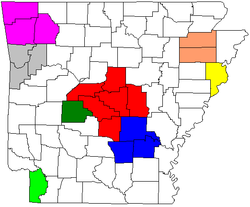
Arkansas Metropolitan Areas
Encyclopedia
United States Census Bureau
The United States Census Bureau is the government agency that is responsible for the United States Census. It also gathers other national demographic and economic data...
as metropolitan.
Among these is one of the fastest growing MSAs in the United States
United States
The United States of America is a federal constitutional republic comprising fifty states and a federal district...
, Fayetteville Springdale-Rogers
Fayetteville-Springdale-Rogers Metropolitan Area
The Fayetteville-Springdale-Rogers Metropolitan Statistical Area as defined by the United States Census Bureau is a four-county area including three Arkansas counties and one Missouri county...
.
Metropolitan areas
- Fayetteville-Springdale-Rogers, AR-MO MSAFayetteville-Springdale-Rogers Metropolitan AreaThe Fayetteville-Springdale-Rogers Metropolitan Statistical Area as defined by the United States Census Bureau is a four-county area including three Arkansas counties and one Missouri county...
: Benton CountyBenton County, ArkansasBenton County is a county located in the U.S. state of Arkansas. As of the 2000 census, the population was 153,406. The U.S. Census Bureau 2010 population is 221,339. The county seat is Bentonville. Benton County was formed on 30 September 1836 and was named after Thomas Hart Benton, a U.S...
, Madison CountyMadison County, ArkansasMadison County is a county located in the U.S. state of Arkansas. As of 2010, the population was 15,717. The county seat is Huntsville. The county was formed on September 30, 1836, and named for James Madison, President of the United States...
, Washington CountyWashington County, ArkansasWashington County is a county located in the northwest part of the U.S. state of Arkansas. As of 2010, the population was 203,065. The county seat is Fayetteville. Washington County is Arkansas's 17th county, formed on October 17, 1828, and named for George Washington, the first President of the...
. - Fort Smith, AR-OK MSAFort Smith metropolitan areaThe Fort Smith Metropolitan Statistical Area, as defined by the United States Census Bureau, is a five-county area including three Arkansas counties and two Oklahoma counties, and anchored by the city of Fort Smith, Arkansas...
: Crawford County, Franklin County, Sebastian County. - Hot Springs, AR MSA: Garland County.
- Jonesboro, AR MSAJonesboro metropolitan areaThe Jonesboro Metropolitan Statistical Area, as defined by the United States Census Bureau, is an area consisting of two counties – Craighead and Poinsett – in northeast Arkansas, anchored by the city of Jonesboro. As of the 2000 census, the MSA had a population of 107,762...
: Craighead County, Poinsett County. - Little Rock-North Little Rock-Conway, AR MSA: Faulkner County, Grant County, Lonoke County, Perry County, Pulaski County, Saline County.
- Memphis, TN-MS AR MSAMemphis Metropolitan AreaThe Memphis Metropolitan Statistical Area, TN-MS-AR , more commonly known as The Mid-South, is the 41st largest among similarly designated areas in the United States. The metropolitan area covers eight counties in three states – Tennessee, Mississippi, and Arkansas...
: Crittenden County. - Pine Bluff, AR MSAPine Bluff metropolitan areaThe Pine Bluff Metropolitan Statistical Area, as defined by the United States Census Bureau, is a three-county region in southeast Arkansas, anchored by the city of Pine Bluff. As of the 2000 census, the MSA had a population of 107,341...
: Cleveland County, Jefferson CountyJefferson County, ArkansasJefferson County is a county located in the U.S. state of Arkansas. Its population was 77,435 at the 2010 United States Census. It is included in the Pine Bluff Metropolitan Statistical Area. Jefferson County's county seat and largest city is Pine Bluff...
, Lincoln CountyLincoln County, ArkansasLincoln County is a county located in the U.S. state of Arkansas and is included in the Pine Bluff Metropolitan Statistical Area. As of 2010, the population is 14,134. The county seat is Star City. Lincoln County is Arkansas's 65th county, formed on March 28, 1871, and named for Abraham Lincoln,...
. - Texarkana, AR TX MSATexarkana metropolitan areaThe Texarkana, TX-Texarkana, AR Metropolitan Statistical Area , as defined by the United States Office of Management and Budget, is a two-county region anchored by the twin cities of Texarkana, Texas and Texarkana, Arkansas, and encompassing the surrounding communities in Bowie County, Texas and...
: Miller County.
Population statistics
The following table lists population figures for these metropolitan areas, in rank of population. Population figures are for the 2010 U.S. Census.| Rank | Metropolitan Area | Population |
|---|---|---|
| 1 | Little Rock-North Little Rock-Conway | 699,757 |
| 2 | Fayetteville Springdale-Rogers Fayetteville-Springdale-Rogers Metropolitan Area The Fayetteville-Springdale-Rogers Metropolitan Statistical Area as defined by the United States Census Bureau is a four-county area including three Arkansas counties and one Missouri county... , AR Arkansas Arkansas is a state located in the southern region of the United States. Its name is an Algonquian name of the Quapaw Indians. Arkansas shares borders with six states , and its eastern border is largely defined by the Mississippi River... /MO Missouri Missouri is a US state located in the Midwestern United States, bordered by Iowa, Illinois, Kentucky, Tennessee, Arkansas, Oklahoma, Kansas and Nebraska. With a 2010 population of 5,988,927, Missouri is the 18th most populous state in the nation and the fifth most populous in the Midwest. It... |
463,204 |
| 3 | Fort Smith Fort Smith metropolitan area The Fort Smith Metropolitan Statistical Area, as defined by the United States Census Bureau, is a five-county area including three Arkansas counties and two Oklahoma counties, and anchored by the city of Fort Smith, Arkansas... , AR Arkansas Arkansas is a state located in the southern region of the United States. Its name is an Algonquian name of the Quapaw Indians. Arkansas shares borders with six states , and its eastern border is largely defined by the Mississippi River... /OK Oklahoma Oklahoma is a state located in the South Central region of the United States of America. With an estimated 3,751,351 residents as of the 2010 census and a land area of 68,667 square miles , Oklahoma is the 28th most populous and 20th-largest state... |
298,592 |
| 4 | Texarkana AR Arkansas Arkansas is a state located in the southern region of the United States. Its name is an Algonquian name of the Quapaw Indians. Arkansas shares borders with six states , and its eastern border is largely defined by the Mississippi River... /TX Texas Texas is the second largest U.S. state by both area and population, and the largest state by area in the contiguous United States.The name, based on the Caddo word "Tejas" meaning "friends" or "allies", was applied by the Spanish to the Caddo themselves and to the region of their settlement in... |
136,027 |
| 5 | Jonesboro Jonesboro metropolitan area The Jonesboro Metropolitan Statistical Area, as defined by the United States Census Bureau, is an area consisting of two counties – Craighead and Poinsett – in northeast Arkansas, anchored by the city of Jonesboro. As of the 2000 census, the MSA had a population of 107,762... |
121,026 |
| 6 | Pine Bluff Pine Bluff metropolitan area The Pine Bluff Metropolitan Statistical Area, as defined by the United States Census Bureau, is a three-county region in southeast Arkansas, anchored by the city of Pine Bluff. As of the 2000 census, the MSA had a population of 107,341... |
100,258 |
| 7 | Hot Springs | 96,024 |
Combined Statistical Areas
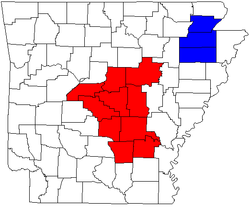
Little Rock-North Little Rock-Pine Bluff combined statistical area
The Little Rock-North Little Rock-Pine Bluff Combined Statistical Area is made up of ten counties in central Arkansas. The statistical area consists of the Little Rock-North Little Rock-Conway Metropolitan Statistical Area, Pine Bluff Metropolitan Statistical Area, and the Searcy Micropolitan Area...
includes the Little Rock and Pine Bluff
Pine Bluff metropolitan area
The Pine Bluff Metropolitan Statistical Area, as defined by the United States Census Bureau, is a three-county region in southeast Arkansas, anchored by the city of Pine Bluff. As of the 2000 census, the MSA had a population of 107,341...
metropolitan areas and the Searcy
Searcy, Arkansas
Searcy is the largest city and county seat of White County, Arkansas, United States. According to 2006 Census Bureau estimates, the population of the city is 20,663. It is the principal city of the Searcy, AR Micropolitan Statistical Area which encompasses all of White County...
micropolitan area. The Jonesboro-Paragould combined statistical area
Jonesboro-Paragould combined statistical area
The Jonesboro-Paragould Combined Statistical Area is made up of three counties in northeastern Arkansas. The CSA consists of the Jonesboro Metropolitan Statistical Area and the Paragould Micropolitan Statistical Area...
was created by the Census Bureau in 2005 and includes the Jonesboro metropolitan area
Jonesboro metropolitan area
The Jonesboro Metropolitan Statistical Area, as defined by the United States Census Bureau, is an area consisting of two counties – Craighead and Poinsett – in northeast Arkansas, anchored by the city of Jonesboro. As of the 2000 census, the MSA had a population of 107,762...
and Paragould
Paragould, Arkansas
-Health & Education:Paragould is home to Arkansas State University Paragould, Arkansas Northeastern College, Black River Technical College, and Crowley's Ridge College. Paragould has two public school districts, the Greene County Technical School District and the Paragould School District, as well...
micropolitan area.
Population statistics
The two Combined Statistical Areas in the state are listed in the table below with their populations from the 2010 census.| Rank | Combined Statistical Area | Population |
|---|---|---|
| 1 | Little Rock-North Little Rock-Pine Bluff Little Rock-North Little Rock-Pine Bluff combined statistical area The Little Rock-North Little Rock-Pine Bluff Combined Statistical Area is made up of ten counties in central Arkansas. The statistical area consists of the Little Rock-North Little Rock-Conway Metropolitan Statistical Area, Pine Bluff Metropolitan Statistical Area, and the Searcy Micropolitan Area... |
877,091 |
| 2 | Jonesboro-Paragould Jonesboro-Paragould combined statistical area The Jonesboro-Paragould Combined Statistical Area is made up of three counties in northeastern Arkansas. The CSA consists of the Jonesboro Metropolitan Statistical Area and the Paragould Micropolitan Statistical Area... |
163,116 |