

Jonesboro metropolitan area
Encyclopedia
United States Census Bureau
The United States Census Bureau is the government agency that is responsible for the United States Census. It also gathers other national demographic and economic data...
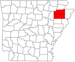
, is an area consisting of two counties – Craighead
Craighead County, Arkansas
Craighead County is a county located in the U.S. state of Arkansas. As of the 2010 census, the population was 96,443. It is included in the Jonesboro, Arkansas Metropolitan Statistical Area. Craighead County is Arkansas's 58th county, formed on February 19, 1859, and named for state Senator Thomas...
and Poinsett – in northeast Arkansas
Arkansas
Arkansas is a state located in the southern region of the United States. Its name is an Algonquian name of the Quapaw Indians. Arkansas shares borders with six states , and its eastern border is largely defined by the Mississippi River...
, anchored by the city of Jonesboro
Jonesboro, Arkansas
Jonesboro is a city in and one of the two county seats of Craighead County, Arkansas, United States. According to the 2010 US Census, the population of the city was 67,263. A college town, Jonesboro is the largest city in northeastern Arkansas and the fifth most populous city in the state...
. As of the 2000 census
United States Census, 2000
The Twenty-second United States Census, known as Census 2000 and conducted by the Census Bureau, determined the resident population of the United States on April 1, 2000, to be 281,421,906, an increase of 13.2% over the 248,709,873 persons enumerated during the 1990 Census...
, the MSA had a population of 107,762 (though a July 1, 2009 estimate placed the population at 120,139). It is also part of the larger Jonesboro-Paragould Combined Statistical Area
Jonesboro-Paragould combined statistical area
The Jonesboro-Paragould Combined Statistical Area is made up of three counties in northeastern Arkansas. The CSA consists of the Jonesboro Metropolitan Statistical Area and the Paragould Micropolitan Statistical Area...
.
Places with 1,000 to 3,000 inhabitants
- BayBay, ArkansasBay is a city in Craighead County, Arkansas, United States. The population was 1,800 at the 2000 census. It is included in the Jonesboro, Arkansas Metropolitan Statistical Area.-Geography:Bay is located at ....
- BonoBono, ArkansasBono is a city in Craighead County, Arkansas, United States. The population was 1,512 at the 2000 census. Population estimate as of 2008 was 1,599. It is included in the Jonesboro, Arkansas Metropolitan Statistical Area...
- BrooklandBrookland, ArkansasBrookland is a town in Craighead County, Arkansas, United States. The population was 1,332 at the 2000 census. It is included in the Jonesboro, Arkansas Metropolitan Statistical Area.-Geography:Brookland is located at ....
- CarawayCaraway, ArkansasCaraway is a town in Craighead County, Arkansas, United States. The population was 1,349 at the 2000 census. It is included in the Jonesboro, Arkansas Metropolitan Statistical Area.-Geography:Caraway is located at ....
- HarrisburgHarrisburg, ArkansasHarrisburg is a city in Poinsett County, Arkansas, United States. The population was 2,192 at the 2000 census. It is included in the Jonesboro, Arkansas Metropolitan Statistical Area...
- Lake CityLake City, ArkansasLake City is a town in Craighead County, Arkansas in the United States, along the St. Francis River. The population is 2,082 according to the 2010 census. It is included in the Jonesboro, Arkansas Metropolitan Statistical Area...
- LepantoLepanto, ArkansasLepanto is a city in Poinsett County, Arkansas, United States. The population was 2,133 at the 2000 census. It is included in the Jonesboro, Arkansas Metropolitan Statistical Area...
- Marked TreeMarked Tree, ArkansasMarked Tree is a city in Poinsett County, Arkansas in the United States, along the St. Francis River, at the mouth of the Little River. The population was 2,800 at the 2000 census. It is included in the Jonesboro, Arkansas Metropolitan Statistical Area....
- MonetteMonette, ArkansasMonette is a city in Craighead County, Arkansas, United States. The population was 1,247 at the 2009 census. It is included in the Jonesboro, Arkansas Metropolitan Statistical Area.-Geography:Monette is located at ....
Places with less than 1,000 inhabitants
- Black OakBlack Oak, ArkansasBlack Oak is a town in Craighead County, Arkansas, USA. The population was 286 at the 2000 census. It is included in the Jonesboro, Arkansas Metropolitan Statistical Area...
- CashCash, ArkansasCash is a town in Craighead County, Arkansas, United States. The population was 294 at the 2000 census. It is included in the Jonesboro, Arkansas Metropolitan Statistical Area.-Geography:Cash is located at ....
- EgyptEgypt, ArkansasEgypt is a town in Craighead County, Arkansas, United States. The population was 101 at the 2000 census. It is included in the Jonesboro, Arkansas Metropolitan Statistical Area.-Geography:Egypt is located at ....
- FisherFisher, ArkansasFisher is a town in Poinsett County, Arkansas, United States. The population was 265 at the 2000 census. It is included in the Jonesboro, Arkansas Metropolitan Statistical Area.-Geography:Fisher is located at ....
- TyronzaTyronza, ArkansasTyronza is a town in Poinsett County, Arkansas, United States. The population was 762 at the 2010 census. It is included in the Jonesboro, Arkansas Metropolitan Statistical Area.-Geography:Tyronza is located at ....
- WaldenburgWaldenburg, ArkansasWaldenburg is a town in Poinsett County, Arkansas, United States. The population was 80 at the 2000 census. It is included in the Jonesboro, Arkansas Metropolitan Statistical Area.-Geography:Waldenburg is located at ....
- WeinerWeiner, ArkansasWeiner is a city in Poinsett County, Arkansas, United States. The population was 760 at the 2000 census. It is included in the Jonesboro, Arkansas Metropolitan Statistical Area.-Geography:Weiner is located at ....
Unincorporated places
- BowmanBowman, Craighead County, ArkansasBowman is an unincorporated community in Craighead County, Arkansas, United States.-April 27, 2011 Tornado:At 3:08 PM on April 27, 2011, a tornado – part of the April 25–28, 2011 tornado outbreak – hit Bowman. The tornado was rated EF-1 with winds at , a width of , that traveled a path of...
- GreenfieldGreenfield, ArkansasGreenfield is an unincorporated community in Poinsett County, Arkansas, United States. A railroad town founded along the Missouri Pacific, it lies five miles north of Harrisburg, and about ten miles south of Jonesboro on the new Highway 1...
- HermanHerman, ArkansasHerman is an unincorporated community in Craighead County, Arkansas, United States. Its location is .-History of the Community Name:The locale of Herman began as a railroad stop with the post office being called Bellefield...
- Lunsford
- Otwell
- PaynewayPayneway, ArkansasPayneway is an unincorporated community in Little River Township, Poinsett County, Arkansas, United States. It is located west of Marked Tree near the intersection of Arkansas Highway 463 and Arkansas Highway 14....
- Pitts
- RivervaleRivervale, ArkansasRivervale is an unincorporated community in Poinsett County, Arkansas, United States, approximately five miles north of Lepanto.The Rivervale Tunnel, an engineering project in which one river flows under another, is located near Rivervale.-External links:*...
- Stacy
- WhitehallWhitehall, Poinsett County, ArkansasWhitehall, Arkansas is an unincorporated community in Scott Township, Poinsett County, Arkansas, United States. Whitehall is located at the intersection of Arkansas Highway 1 and Arkansas Highway 214....
Demographics
As of the censusCensus
A census is the procedure of systematically acquiring and recording information about the members of a given population. It is a regularly occurring and official count of a particular population. The term is used mostly in connection with national population and housing censuses; other common...
of 2000, there were 107,762 people, 42,327 households, and 29,321 families residing within the MSA. The racial makeup of the MSA was 89.68% White, 7.63% African American, 0.31% Native American, 0.50% Asian, 0.02% Pacific Islander, 0.88% from other races
Race (United States Census)
Race and ethnicity in the United States Census, as defined by the Federal Office of Management and Budget and the United States Census Bureau, are self-identification data items in which residents choose the race or races with which they most closely identify, and indicate whether or not they are...
, and 0.98% from two or more races. Hispanic or Latino of any race were 1.95% of the population.
The median income for a household in the MSA was $29,492, and the median income for a family was $36,473. Males had a median income of $28,500 versus $20,154 for females. The per capita income
Per capita income
Per capita income or income per person is a measure of mean income within an economic aggregate, such as a country or city. It is calculated by taking a measure of all sources of income in the aggregate and dividing it by the total population...
for the MSA was $15,089.
See also
- Arkansas metropolitan areasArkansas Metropolitan AreasThe State of Arkansas has a total of eight metropolitan statistical areas that are fully or partially located in the state. Twenty of the state's 75 counties are classified by the United States Census Bureau as metropolitan....
- List of cities in Arkansas
- List of United States metropolitan areas