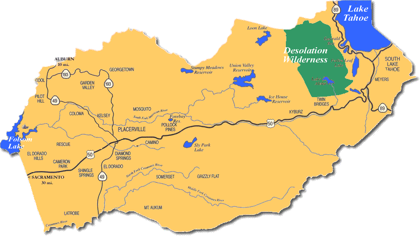
Twin Bridges, California
Encyclopedia

Unincorporated area
In law, an unincorporated area is a region of land that is not a part of any municipality.To "incorporate" in this context means to form a municipal corporation, a city, town, or village with its own government. An unincorporated community is usually not subject to or taxed by a municipal government...
on U.S. Route 50
U.S. Route 50 in California
In the U.S. state of California, U.S. Route 50 runs east from I-80 in West Sacramento to the Nevada state line in South Lake Tahoe. Portions within Sacramento are known as the Capital City Freeway and El Dorado Freeway...
near the Desolation Wilderness
Desolation Wilderness
The Desolation Wilderness is a federally protected wilderness area located along the crest of the Sierra Nevada mountain range, just southwest of Lake Tahoe in El Dorado County, California, United States. It is a popular backpacking destination, with much barren rocky terrain at the edge of the...
in El Dorado County
El Dorado County, California
El Dorado County is a county located in the historic Gold Country in the Sierra Nevada Mountains and foothills of the U.S. state of California. The 2010 population was 181,058. The El Dorado county seat is in Placerville....
, California
California
California is a state located on the West Coast of the United States. It is by far the most populous U.S. state, and the third-largest by land area...
. It is located 5 miles (8 km) west of Echo Summit
Echo Summit
Echo Summit is a mountain pass located in eastern El Dorado County, California, USA. At an elevation of , it is the highest point on U.S...
, at an elevation of 6115 feet (1864 m). It has a population of 14 people according to census figures, however as of 2008 the road sign lists the population at 10. Right after the town, the U.S. 50 eastbound starts a steep ascent to Echo Summit
Echo Summit
Echo Summit is a mountain pass located in eastern El Dorado County, California, USA. At an elevation of , it is the highest point on U.S...
passing Sierra-at-Tahoe
Sierra-at-Tahoe
Sierra-at-Tahoe is a ski and snowboard resort in Twin Bridges, California south of Lake Tahoe. Sierra-at-Tahoe is approximately 16 miles south of Stateline, Nevada and 12 miles south of South Lake Tahoe on Highway 50 and is contained within the Eldorado National Forest...
ski resort
Ski resort
A ski resort is a resort developed for skiing and other winter sports. In Europe a ski resort is a town or village in a ski area - a mountainous area, where there are ski trails and supporting services such as hotels and other accommodation, restaurants, equipment rental and a ski lift system...
shortly before the summit.
When snow chains
Snow chains
Snow chains, or tire chains, are devices fitted to the tires of vehicles to provide maximum traction when driving through snow and ice....
are required on the summit, Caltrans
California Department of Transportation
The California Department of Transportation is a government department in the U.S. state of California. Its mission is to improve mobility across the state. It manages the state highway system and is actively involved with public transportation systems throughout the state...
often establishes chain control in Twin Bridges. This is likely because of very limited availability of shoulders where chains can be installed on summit approaches.
The ZIP code
ZIP Code
ZIP codes are a system of postal codes used by the United States Postal Service since 1963. The term ZIP, an acronym for Zone Improvement Plan, is properly written in capital letters and was chosen to suggest that the mail travels more efficiently, and therefore more quickly, when senders use the...
s are 95721 and 95735. The community is inside area code 530
Area code 530
North American area code 530 is a California telephone area code that covers Auburn, Chico, Colfax, Davis, Grass Valley, Marysville, Oroville, Placerville, Redding, Red Bluff, Susanville, Truckee, Woodland, Yuba City and South Lake Tahoe....
.
The former ski area Edelweiss was just above Twin Bridges on US-50, at what is now called Camp Sacramento. It was the home hill for future Olympian
Alpine skiing at the 1968 Winter Olympics
Alpine skiing at the 1968 Winter Olympics consisted of six events, held near Grenoble, France. The six events were held at Chamrousse from February 9–17, 1968.Jean-Claude Killy won all three men's events, repeating Toni Sailer's triple-gold of 1956...
ski racer
Alpine skiing
Alpine skiing is the sport of sliding down snow-covered hills on skis with fixed-heel bindings. Alpine skiing can be contrasted with skiing using free-heel bindings: Ski mountaineering and nordic skiing – such as cross-country; ski jumping; and Telemark. In competitive alpine skiing races four...
Spider Sabich
Spider Sabich
Vladimir Peter Sabich, Jr. was an American alpine ski racer. He was a member of the U.S. Ski Team in the late 1960s and competed at the 1968 Winter Olympics; he was the pro ski racing champion in 1971 & 1972.-Early life:...
. He was raised in Kyburz
Kyburz, California
Kyburz is a small unincorporated community in El Dorado County, California. It is located along the South Fork of the American River and U.S. Highway 50, and is surrounded by the El Dorado National Forest...
, twelve miles (20 km) west, in the 1950s and early 1960s.
A post office opened in Twin Bridges in 1947.
Demographics
The population is 100% white; 50% male, 50% female. The average household size is 2 and the average family size is 2.2. There are 125 housing units which are largely unoccupied vacation homes. 100% of the population speaks the English languageEnglish language
English is a West Germanic language that arose in the Anglo-Saxon kingdoms of England and spread into what was to become south-east Scotland under the influence of the Anglian medieval kingdom of Northumbria...
.
External links
- Statistics
- Topographic map & aerial photo from USGS via Microsoft Research Maps

