

Archaeological illustration
Encyclopedia
Technical illustration
Technical Illustration is the use of illustration to visually communicate information of a technical nature. Technical illustrations can be components of technical drawings or diagrams...
that records material derived from an archaeological context graphically.
Overview
Archaeological Illustration encompasses a number of sub disciplines. These are:- SurveyingSurveyingSee Also: Public Land Survey SystemSurveying or land surveying is the technique, profession, and science of accurately determining the terrestrial or three-dimensional position of points and the distances and angles between them...
: To produce an accurate record of sites and buildings and to record accurately where the sites and buildings lie within the landscape. Surveyors use a range of equipment including tapes, plane tablesPlane tableA plane table is a device used in surveying and related disciplines to provide a solid and level surface on which to make field drawings, charts and maps...
, total stationsTotal stationA total station is an electronic/optical instrument used in modern surveying. The total station is an electronic theodolite integrated with an electronic distance meter to read slope distances from the instrument to a particular point....
, 3D scanners3D scannerA 3D scanner is a device that analyzes a real-world object or environment to collect data on its shape and possibly its appearance . The collected data can then be used to construct digital, three dimensional models....
, GPS and GIS to produce illustrations including plansArchaeological planAn archaeological plan in an archaeological excavation, is a drawn record of features in the horizontal plane.- Overview :Archaeological plan can either take the form of...
, sectionsArchaeological sectionIn archaeology a section is a view in part of the archaeological sequence showing it in the vertical plane, as a cross section, and thereby illustrating its profile and stratigraphy. This may make it easier to view and interpret as it developed over time....
and elevations as well as isometricIsometric projectionIsometric projection is a method for visually representing three-dimensional objects in two dimensions in technical and engineering drawings...
and axonometricAxonometric projectionAxonometric projection is a type of parallel projection, more specifically a type of orthographic projection, used to create a pictorial drawing of an object, where the object is rotated along one or more of its axes relative to the plane of projection....
illustrations which are regularly used in building recording. Survey data will be gathered on acid free paper, polyvinyl permatracePolyvinyl chloridePolyvinyl chloride, commonly abbreviated PVC, is a thermoplastic polymer. It is a vinyl polymer constructed of repeating vinyl groups having one hydrogen replaced by chloride. Polyvinyl chloride is the third most widely produced plastic, after polyethylene and polypropylene. PVC is widely used in...
and archive stable digital formats.
- PhotographyPhotographyPhotography is the art, science and practice of creating durable images by recording light or other electromagnetic radiation, either electronically by means of an image sensor or chemically by means of a light-sensitive material such as photographic film...
: To produce a record of archaeological sites, buildings, artifacts and landscapes. Archaeological photographers will uses a range of different formats particularly black-and-white and colour slide. Digital photographyDigital photographyDigital photography is a form of photography that uses an array of light sensitive sensors to capture the image focused by the lens, as opposed to an exposure on light sensitive film...
is now starting to become more widely used and is especially useful for the recording of historic building. Aerial photographyAerial archaeologyAerial archaeology is the study of archaeological remains by examining them from altitude.The advantages of gaining a good aerial view of the ground had been long appreciated by archaeologists as a high viewpoint permits a better appreciation of fine details and their relationships within the wider...
is commonly used as a tool for recording sites and is also used as a prospecting tool to locate new archaeological sites.
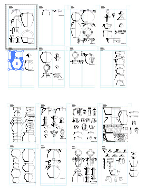
- ArtefactArtifact (archaeology)An artifact or artefact is "something made or given shape by man, such as a tool or a work of art, esp an object of archaeological interest"...
illustration : To record objects using agreed conventionsConvention (norm)A convention is a set of agreed, stipulated or generally accepted standards, norms, social norms or criteria, often taking the form of a custom....
to allow further study of the objects by specialists on publication. Artefact illustrators will use pen-and-ink as well as graphics and page layout softwareGraphics softwareIn computer graphics, graphics software or image editing software is a program or collection of programs that enable a person to manipulate visual images on a computer....
.
- Interpretation and reconstruction illustration : To visualise the results of archaeological field work in a way that is meaningful and visually appealing to as many as possible. Reconstruction artists work in many media from traditional pen-and-ink and painted reconstruction to more modern techniques including 3D, virtual realityVirtual realityVirtual reality , also known as virtuality, is a term that applies to computer-simulated environments that can simulate physical presence in places in the real world, as well as in imaginary worlds...
and videoVideoVideo is the technology of electronically capturing, recording, processing, storing, transmitting, and reconstructing a sequence of still images representing scenes in motion.- History :...
.
See also
- Archaeological field surveyArchaeological field surveyArchaeological field survey is the method by which archaeologists search for archaeological sites and collect information about the location, distribution and organization of past human cultures across a large area...
- Archaeological planArchaeological planAn archaeological plan in an archaeological excavation, is a drawn record of features in the horizontal plane.- Overview :Archaeological plan can either take the form of...
- Archaeological recordArchaeological recordThe archaeological record is the body of physical evidence about the past. It is one of the most basic concepts in archaeology, the academic discipline concerned with documenting and interpreting the archaeological record....
- Archaeological sectionArchaeological sectionIn archaeology a section is a view in part of the archaeological sequence showing it in the vertical plane, as a cross section, and thereby illustrating its profile and stratigraphy. This may make it easier to view and interpret as it developed over time....
- Excavation (archaeology)
- Post excavationPost excavationIn archaeology once the archaeological record of given site has been excavated, or collected from surface surveys, it is necessary to gain as much data as possible and organize it into a coherent body of information. This process is known as post-excavation analysis, and is normally the most...
- Training excavationTraining excavationTraining excavations are normally run by University departments or large contractors and employ professional archaeologists in several disciplines to teach the basics of archaeological methodology, including photography, stratigraphy, illustration and draughtsmanship as well as survey, finds...
Further reading
- Philip Barker (1977). Techniques of Archaeological Excavation, Batsford
- John Hodgson (2000). Archaeological reconstruction: illustrating the past, AAI&S & IFA
- Melanie Steiner (2005). Approaches to Archaeological Illustration: A Handbook, Council for British Archaeology
- The MoLAS archaeological site manual MoLAS, London 1994.