

Apsley River (New South Wales)
Encyclopedia
Northern Tablelands, New South Wales
The Northern Tablelands, also known as the New England Tableland, is a plateau and a region of the Great Dividing Range in northern New South Wales, Australia. It includes the New England Range, the narrow highlands area of the New England region, stretching from the Moonbi Range in the south to...
of New South Wales
New South Wales
New South Wales is a state of :Australia, located in the east of the country. It is bordered by Queensland, Victoria and South Australia to the north, south and west respectively. To the east, the state is bordered by the Tasman Sea, which forms part of the Pacific Ocean. New South Wales...
, Australia
Australia
Australia , officially the Commonwealth of Australia, is a country in the Southern Hemisphere comprising the mainland of the Australian continent, the island of Tasmania, and numerous smaller islands in the Indian and Pacific Oceans. It is the world's sixth-largest country by total area...
. The headwaters of the river rise in high country about 11 kilometres west of Tia
Tia, New South Wales
Tia, is a settlement and parish located approximately 30 kilometres east of Walcha, on the Northern Tablelands region of New South Wales, Australia....
and approximately 29 km south of Walcha, New South Wales
Walcha, New South Wales
Walcha is a parish and town at the south-eastern edge of the Northern Tablelands, New South Wales, Australia.The town serves as the seat of Walcha Shire. Walcha is located 425 kilometres by road from Sydney at the intersection of the Oxley Highway and Thunderbolts Way...
.
Geography
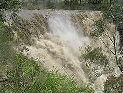
The river flows through the town of Walcha and on to make a dramatic spilling over the Apsley FallsApsley Falls
The Apsley Falls are two waterfalls on the Apsley River on the Northern Tablelands, New South Wales, Australia. The falls are located about east of Walcha, and 1 kilometre off the Oxley Highway in a deep gorge, that is part of the Oxley Wild Rivers National Park...
into the Apsley Gorge, on its way to join the Macleay River
Macleay River
The Macleay River is a major river on the Mid North Coast , Australia.The headwaters of the Macleay River rise as the Gara River on the eastern side of the Northern Tablelands near Armidale and Walcha, New South Wales. From here the Chandler River, Styx River and Apsley Rivers are important...
which is about 24 km south west of the locality of Lower Creek. The Macleay and Apsley Rivers have developed deeply incised river valleys into Ordovician
Ordovician
The Ordovician is a geologic period and system, the second of six of the Paleozoic Era, and covers the time between 488.3±1.7 to 443.7±1.5 million years ago . It follows the Cambrian Period and is followed by the Silurian Period...
meta-sedimentary rocks including greywacke
Greywacke
Greywacke or Graywacke is a variety of sandstone generally characterized by its hardness, dark color, and poorly sorted angular grains of quartz, feldspar, and small rock fragments or lithic fragments set in a compact, clay-fine matrix. It is a texturally immature sedimentary rock generally found...
, slate
Slate
Slate is a fine-grained, foliated, homogeneous metamorphic rock derived from an original shale-type sedimentary rock composed of clay or volcanic ash through low-grade regional metamorphism. The result is a foliated rock in which the foliation may not correspond to the original sedimentary layering...
, phyllite
Phyllite
Phyllite is a type of foliated metamorphic rock primarily composed of quartz, sericite mica, and chlorite; the rock represents a gradation in the degree of metamorphism between slate and mica schist. Minute crystals of graphite, sericite, or chlorite impart a silky, sometimes golden sheen to the...
, schist
Schist
The schists constitute a group of medium-grade metamorphic rocks, chiefly notable for the preponderance of lamellar minerals such as micas, chlorite, talc, hornblende, graphite, and others. Quartz often occurs in drawn-out grains to such an extent that a particular form called quartz schist is...
, chert
Chert
Chert is a fine-grained silica-rich microcrystalline, cryptocrystalline or microfibrous sedimentary rock that may contain small fossils. It varies greatly in color , but most often manifests as gray, brown, grayish brown and light green to rusty red; its color is an expression of trace elements...
and argillite
Argillite
An argillite is a fine-grained sedimentary rock composed predominantly of indurated clay particles. Argillaceous rocks are basically lithified muds and oozes. They contain variable amounts of silt-sized particles. The argillites grade into shale when the fissile layering typical of shale is...
s. This has produced a number of spectacular gorges
Gorges
Gorges, the plural of the French word for "throat", usually refers to a canyon.Gorges is the name or part of the name of several communes in France:* Gorges, in the Loire-Atlantique département* Gorges, in the Manche département...
and waterfalls on or near the Apsley River in the Oxley Wild Rivers National Park
Oxley Wild Rivers National Park
Oxley Wild Rivers National Park is in New South Wales, Australia, 445 kilometres north of Sydney and is named in memory of the Australian explorer John Oxley, who passed through the area in 1818...
. The Macleay River enters the Pacific Ocean
Pacific Ocean
The Pacific Ocean is the largest of the Earth's oceanic divisions. It extends from the Arctic in the north to the Southern Ocean in the south, bounded by Asia and Australia in the west, and the Americas in the east.At 165.2 million square kilometres in area, this largest division of the World...
at South West Rocks
South West Rocks, New South Wales
South West Rocks is located on the Mid North Coast of New South Wales, Australia, near the mouth of the Macleay River. It is approximately 40 km from Kempsey. Jerseyville is located nearby....
.
The Apsley Macleay Gorges are a converging point for moister eastern coastal and dry western floras, and some 950 native plant species have been identified, of which 36 are rare or threatened. The gorge wattle is a rare species that mainly grows in the Apsley Macleay gorges. Epiphytic orchids may also be observed growing in trees, too.
The main tributaries of the Apsley River are:
Bergen Op Zoom Creek, Brookmount Creek, Dog Trap Creek, Doravale Creek, Emu Creek, Green Gully, Maineys Creek, My Ladys Creek, Ohio Creek, Peters Creek, Rowleys Creek, Rusdens Creek, Stony Creek, Teatree Creek, Tiara Creek, Tia River
Tia River
The Tia River is a river on the Northern Tablelands of New South Wales, Australia. The headwaters of the river rise in high country on the eastern slopes of the Great Dividing Range about south west of Tia. It flows generally north east crossing the Oxley Highway before spilling over the Tia Falls...
, Trinidad Creek, Wilsons Creek, and Yarrowitch River
Yarrowitch River
The Yarrowitch River is a river on the Northern Tablelands of New South Wales, Australia.The headwaters of the river rise in high country on the eastern slopes of the Great Dividing Range about 11 kilometres south west of Yarrowitch. It flows generally north north east crossing the Oxley Highway...
.
The entire length of the Apsley River is within the boundaries of Walcha Shire and Vernon County
Vernon County, New South Wales
Vernon County is one of the 141 Cadastral divisions of New South Wales, Australia. The Macleay River is part of the border in the north-east. It includes Walcha.Vernon County was named in honour of George John Venables-Vernon, 5th Baron Vernon ....
.
History
The area was occupied by the Ngayaywana and Dyangadi AboriginalAustralian Aborigines
Australian Aborigines , also called Aboriginal Australians, from the latin ab originem , are people who are indigenous to most of the Australian continentthat is, to mainland Australia and the island of Tasmania...
prior to white settlement. Archaeological evidence of Aboriginal camp sites have been found on the upper terraces of the Apsley and Macleay Rivers.
In 1818 explorer, John Oxley
John Oxley
John Joseph William Molesworth Oxley was an explorer and surveyor of Australia in the early period of English colonisation.October 1802 he was engaged in coastal survey work including an expedition to Western Port in 1804-05...
, camped beside the Apsley River very near the present townsite en route to the coast. He recorded the event in his diary that day: "We halted in a fine and spacious valley ... watered by a fine brook, and at a distance of a mile we saw several fires at which appeared many natives." A cairn now marks his campsite alongside the Apsley River, which Oxley named after Lord Apsley, the then Secretary of State for colonies.
Australian red cedar (Toona ciliata
Toona ciliata
Australian Red Cedar , Toona ciliata is a forest tree in the family Meliaceae which grows throughout southern Asia from Afghanistan to Papua New Guinea and Australia. In Australia its natural habitat is now extensively cleared subtropical rainforests of New South Wales and Queensland...
) cutters were active in the area's rainforests before 1860. Some red cedar trees may still be seen in the more remote tributaries of the river.
In 1862 Walcha’s doctor William Vint Aspinall (1828-1862) drowned while bathing in the Apsley River.
The Apsley River flooded Walcha in 1893, 1935, 1941 and 1952. The maximum period between floods up to 1962 was ten years. Walcha's worst flood was on 12 January 1962, when 40 business houses and 39 residences were flooded. Losses were in the vicinity of $250,000. A public appeal raised $11,000 and the Armidale Lord Mayor's fund gave eight thousand six hundred fifty pounds. It cost the Walcha Shire $2,000 to clean up the town, however the amount of work carried out by volunteers would have doubled this figure.
In September, 1967 Walcha Council decided to proceed with flood mitigation
Flood mitigation
Flood mitigation involves managing the effects of flooding, such as redirecting flood run-off, rather than trying to prevent it altogether. It is management of people, through measures such as evacuation and dry/wet proofing properties for example....
, provided it did not exceed $140,000. By September 1971, all required land had been resumed to give the council full control for flood mitigation purposes. The scheme was almost complete by October 1973 and the flood warning system on “Somerset” became redundant. Since the construction of the levee
Levee
A levee, levée, dike , embankment, floodbank or stopbank is an elongated naturally occurring ridge or artificially constructed fill or wall, which regulates water levels...
banks there has been no further flooding of the township.
The deep "Mill Hole" in the Apsley River, above the Fitzroy Street bridge, was used as the local swimming hole until the Walcha and District War Memorial Baths were completed in October 1970.
In 1981 the N.S.W. Electricity Commission proposed to build a large pumped storage scheme on the Apsley River to supply electricity for peak energy demand periods. During late 1981 Elcom improved the Cicolini Trail to the Apsley River and installed a river gauging station. The project was shelved following a land use study recommending a major national park be established. In 1986 the park was gazetted to foster nature conservation, cultural heritage and tourism on the Northern Tablelands.
The Lower Apsley River Landcare
Landcare
Landcare may refer to:*Landcare , a group formed to seek land protection*Landcare Australia, an umbrella organisation seeking land protection in Australia*Landcare Research New Zealand Limited*Landcare...
Group was formed in 1993 to improve the health of the riparian zone of the Apsley River. This landcare group encompasses an area of approximately 300 km² between Walcha and the Oxley Wild Rivers National Park. The 12 active members of the group have worked tirelessly towards this goal. Over the years they have planted 320,000 trees across 140 sites, most of which are now thriving.
In 2007 the two lane (with a pedestrian pathway) Middle Street bridge replaced the old single lane wooden bridge over the Apsley River in Walcha.
The Apsley River flooded on 28 November 2008, causing major damage to farming properties and livestock
Livestock
Livestock refers to one or more domesticated animals raised in an agricultural setting to produce commodities such as food, fiber and labor. The term "livestock" as used in this article does not include poultry or farmed fish; however the inclusion of these, especially poultry, within the meaning...
losses. The levee banks saved Walcha township from flooding.
Dingo
Dingo
The Australian Dingo or Warrigal is a free-roaming wild dog unique to the continent of Australia, mainly found in the outback. Its original ancestors are thought to have arrived with humans from southeast Asia thousands of years ago, when dogs were still relatively undomesticated and closer to...
s, brumbies
Brumby
A Brumby is a free-roaming feral horse in Australia. Although found in many areas around the country, the best-known brumbies are found in the Australian Alps region in south-eastern Australia. Today, most of them are found in the Northern Territory, with the second largest population in Queensland...
, carpet pythons, goanna
Goanna
Goanna is the name used to refer to any number of Australian monitor lizards of the genus Varanus, as well as to certain species from Southeast Asia.There are around 30 species of goanna, 25 of which are found in Australia...
s and feral pigs inhabit parts of the warmer, lower reaches of the Apsley River.
See also
- Apsley FallsApsley FallsThe Apsley Falls are two waterfalls on the Apsley River on the Northern Tablelands, New South Wales, Australia. The falls are located about east of Walcha, and 1 kilometre off the Oxley Highway in a deep gorge, that is part of the Oxley Wild Rivers National Park...
- List of rivers in New South Wales (A-K)