

Amphoe Thalang
Encyclopedia
Thalang is a district (amphoe
) in the north of Phuket Province
, Thailand
.
Thalang. The governor then had the title Phraya Thalang (พระยาถลาง). In 1898 the current district was established.
and Kathu
, while to the north is Takua Thung
of Phang Nga Province
, separated by the Pak Prah strait.
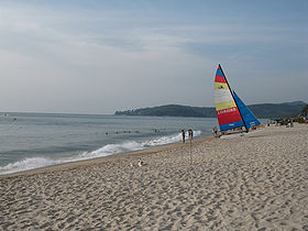
within the hills of the district. The three highest peaks of this reserve are the Khao Prathiu (384 m), Khao Bang Pae (388 m) and Khao Phara (422 m). The Sirinat National Park on the northwestern coast was established in 1981 and protects an area of 90 km² (68 km² marine area), including the Nai Yang beach where sea turtle
s lay their eggs.
At the heroines monument in the south of the district a branch museum of the National Museum
was opened in 1989. The monument itself commemorates the local heroines Thao Thep Kasattri and Thao Sri Sunthon, who forced the Burmese army sieging the town of Thaland to retreat.
is located within the district. The main road is Highway 402, which runs from the bridge over the Pak Prah strait till Phuket city.
), which are further subdivided into 46 villages (muban
). Thep Krasattri and Choeng Thale have subdistricts municipality (thesaban tambon) status, each covering part of the same-named tambon. Each of the 6 tambon is administrated by a Tambon administrative organization (TAO).
Amphoe
An amphoe is the second level administrative subdivision of Thailand. Usually translated as district, amphoe make up the provinces, and are analogous to a county seat...
) in the north of Phuket Province
Phuket Province
Phuket , formerly known as Thalang and, in Western sources, Junk Ceylon , is one of the southern provinces of Thailand...
, Thailand
Thailand
Thailand , officially the Kingdom of Thailand , formerly known as Siam , is a country located at the centre of the Indochina peninsula and Southeast Asia. It is bordered to the north by Burma and Laos, to the east by Laos and Cambodia, to the south by the Gulf of Thailand and Malaysia, and to the...
.
History
Thalang was the original center of Phuket province, then named MueangMueang
Mueang were historical semi-independent city-states or principalities in present-day Thailand, Laos, parts of northern Vietnam and the Shan State of Myanmar. Smaller Mueang were subordinate to more powerful neighboring Mueang, which in turn were subordinate to the central king, as described in...
Thalang. The governor then had the title Phraya Thalang (พระยาถลาง). In 1898 the current district was established.
Geography
The district borders to the south Mueang PhuketAmphoe Mueang Phuket
Amphoe Mueang Phuket is the capital district of Phuket Province. The town Phuket itself is in the northwest of the district.-Geography:The district covers the southern part of the island Phuket...
and Kathu
Amphoe Kathu
Kathu is a district of Phuket Province, located in the west of the island. It neighbors Thalang to the north, Mueang Phuket to the east and south, and the Andaman Sea to the west.-Geography:...
, while to the north is Takua Thung
Amphoe Takua Thung
Takua Thung is a district in the province Phang Nga in the south of Thailand.-History:Mueang Takua Thung is an ancient city same as Phang Nga and Takua Pa. The old city hall was located in Ban Khai, Tambon Bang Thong, Amphoe Thai Mueang. In 1894 Burmese troops attacked Mueang Takua Pa. Thalang...
of Phang Nga Province
Phang Nga Province
Phang Nga is one of the southern provinces of Thailand, on the shore to the Andaman Sea. Neighboring provinces are Ranong, Surat Thani and Krabi. To the south is the Phuket province, but without land boundary to Phang Nga....
, separated by the Pak Prah strait.
Places
The Khao Phra Thaeo Non-hunting Area protects more than 20 km² of rainforestRainforest
Rainforests are forests characterized by high rainfall, with definitions based on a minimum normal annual rainfall of 1750-2000 mm...
within the hills of the district. The three highest peaks of this reserve are the Khao Prathiu (384 m), Khao Bang Pae (388 m) and Khao Phara (422 m). The Sirinat National Park on the northwestern coast was established in 1981 and protects an area of 90 km² (68 km² marine area), including the Nai Yang beach where sea turtle
Sea turtle
Sea turtles are marine reptiles that inhabit all of the world's oceans except the Arctic.-Distribution:...
s lay their eggs.
At the heroines monument in the south of the district a branch museum of the National Museum
National Museum (Thailand)
The National Museum in Thailand is the main museum on the history of the Thai culture. The main museum is located in Bangkok on Na Phrathat Road next to the Sanam Luang, not far from Wat Phra Kaew....
was opened in 1989. The monument itself commemorates the local heroines Thao Thep Kasattri and Thao Sri Sunthon, who forced the Burmese army sieging the town of Thaland to retreat.
Traffic
Phuket International AirportPhuket International Airport
Phuket International Airport is an airport serving the Phuket Province of Thailand. It is located in the north of Phuket Island, 32 kilometres from the centre of Phuket City. The airport plays a major role in Thailand's tourism industry, as Phuket Island is a popular resort destination...
is located within the district. The main road is Highway 402, which runs from the bridge over the Pak Prah strait till Phuket city.
Administration
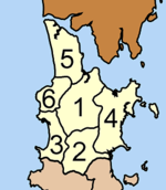
The district is subdivided into 6 subdistricts (tambonTambon
Tambon is a local government unit in Thailand. Below district and province , they form the third administrative subdivision level. As of the 2009 there are 7255 tambon, not including the 169 khwaeng of Bangkok, which are set at the same administrative level, thus every district contains 8-10 tambon...
), which are further subdivided into 46 villages (muban
Muban
Muban is the lowest administrative subdivision of Thailand. Usually translated as village, they are the subdivision of tambon. As of 2008, there are 74944 administrative villages in Thailand. As of the 1990 census, the average village consisted of 144 households or 746 persons.A muban does not...
). Thep Krasattri and Choeng Thale have subdistricts municipality (thesaban tambon) status, each covering part of the same-named tambon. Each of the 6 tambon is administrated by a Tambon administrative organization (TAO).
|
 |