
Amphoe Hua Sai
Encyclopedia
Hua Sai is a district (Amphoe
) in the southeastern part of Nakhon Si Thammarat Province
, southern Thailand
.
of Songkhla Province
, Khuan Khanun
and Pa Phayom
of Phattalung Province, Cha-uat
, Chian Yai
and Pak Phanang
of Nakhon Si Thammarat Province. To the east is the Gulf of Thailand
.
. In the same year the district office was moved to its present location to village 8 of tambon Hua Sai. 1937 the district regained full district status.
), which are further subdivided into 99 villages (muban
). Hua Sai is a township (thesaban tambon) which covers parts of tambon Hua Sai and Na Saton. There are further 11 Tambon administrative organizations (TAO).
Amphoe
An amphoe is the second level administrative subdivision of Thailand. Usually translated as district, amphoe make up the provinces, and are analogous to a county seat...
) in the southeastern part of Nakhon Si Thammarat Province
Nakhon Si Thammarat Province
Nakhon Si Thammarat is one of the southern provinces of Thailand, at the eastern shore of the Gulf of Thailand...
, southern Thailand
Southern Thailand
Southern Thailand is a distinct region of Thailand, connected with the Central region by the narrow Kra Isthmus.-Geography:Southern Thailand is located on the Malay Peninsula, with an area around 70,713 km², bounded to the north by Kra Isthmus as the narrowest part of the peninsula. The...
.
Geography
Neighboring districts are (from the south clockwise) RanotAmphoe Ranot
Ranot is the northernmost district of Songkhla Province, southern Thailand.-Geography:Neighboring districts are Sathing Phra, Krasae Sin of Songkhla Province, Mueang Phatthalung, Khuan Khanun of Phatthalung Province, Cha-uat and Hua Sai of Nakhon Si Thammarat Province...
of Songkhla Province
Songkhla Province
Songkhla is one of the southern provinces of Thailand. Neighboring provinces are Satun, Phatthalung, Nakhon Si Thammarat, Pattani and Yala. To the south it borders Kedah and Perlis of Malaysia....
, Khuan Khanun
Amphoe Khuan Khanun
Khuan Khanun is a district of Phatthalung Province, southern Thailand.-Geography:Neighboring districts are Mueang Phatthalung, Srinagarindra, Si Banphot and Pa Phayom of Phatthalung Province, Cha-uat of Nakhon Si Thammarat Province, and Ranot of Songkhla Province.The Phru Khuan Khi Sian wetlands...
and Pa Phayom
Amphoe Pa Phayom
Pa Phayom is the northernmost district of Phatthalung Province, southern Thailand.-Geography:Neighboring districts are Khuan Khanun, Si Banphot of Phattalung Province, Huai Yot of Trang Province and Cha-uat of Nakhon Si Thammarat Province.-History:The minor district was established on January...
of Phattalung Province, Cha-uat
Amphoe Cha-uat
Cha-uat is a district in the southern part of Nakhon Si Thammarat Province, southern Thailand.-Geography:Neighboring districts are Thung Song, Chulabhorn, Ron Phibun, Chaloem Phra Kiat, Chian Yai and Hua Sai of Nakho Si Thammarat Province, Ranot of Songkhla Province, Khuan Khanun and Pa Phayom...
, Chian Yai
Amphoe Chian Yai
Chian Yai is a district in the southeastern part of Nakhon Si Thammarat Province, southern Thailand.-Geography:Neighboring districts are Pak Phanang, Hua Sai, Cha-uat and Chaloem Phra Kiat.-History:...
and Pak Phanang
Amphoe Pak Phanang
Pak Phanang is a district of Nakhon Si Thammarat Province, southern Thailand.The name of district means Sheltered Mouth, referring to the mouth of the Pak Phanang river protected from the open sea by a long peninsula.- History :...
of Nakhon Si Thammarat Province. To the east is the Gulf of Thailand
Gulf of Thailand
The Gulf of Thailand , also known in to Malays as Teluk Siam literally meant Gulf of Siam, is a shallow arm of the South China Sea.-Geography:...
.
History
The district was established in 1904, then named Khao Phang Krai (เขาพังไกร), as the administrative center was located in tambon Khao Phang Krai. When the center was moved in 1906 to tambon Hua Sai the district was renamed accordingly. In 1924 the district was reduced to a minor district (King Amphoe) under Pak Phanang districtAmphoe Pak Phanang
Pak Phanang is a district of Nakhon Si Thammarat Province, southern Thailand.The name of district means Sheltered Mouth, referring to the mouth of the Pak Phanang river protected from the open sea by a long peninsula.- History :...
. In the same year the district office was moved to its present location to village 8 of tambon Hua Sai. 1937 the district regained full district status.
Administration
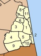
The district is subdivided into 11 subdistricts (tambonTambon
Tambon is a local government unit in Thailand. Below district and province , they form the third administrative subdivision level. As of the 2009 there are 7255 tambon, not including the 169 khwaeng of Bangkok, which are set at the same administrative level, thus every district contains 8-10 tambon...
), which are further subdivided into 99 villages (muban
Muban
Muban is the lowest administrative subdivision of Thailand. Usually translated as village, they are the subdivision of tambon. As of 2008, there are 74944 administrative villages in Thailand. As of the 1990 census, the average village consisted of 144 households or 746 persons.A muban does not...
). Hua Sai is a township (thesaban tambon) which covers parts of tambon Hua Sai and Na Saton. There are further 11 Tambon administrative organizations (TAO).
|
 |
External links
- amphoe.com
- http://www.huasai.go.th Hua Sai TAO (Thai)