

Amphoe Pak Phanang
Encyclopedia
Pak Phanang is a district (Amphoe
) of Nakhon Si Thammarat Province
, southern Thailand
.
The name of district means Sheltered Mouth, referring to the mouth of the Pak Phanang river protected from the open sea by a long peninsula.
On October 25, 1962 Tropical Storm Harriet hit the district. The low Talumphuk peninsula to the north of the district was completely devastated, and even in the town Pak Phanang itself the storm surge made the water rise to 4 meter depth. The flooding caused more than 1000 fatalities, and many more homeless.
, Chian Yai
, Chaloem Phra Kiat
and Mueang Nakhon Si Thammarat
. To the east is the Gulf of Thailand
.
The most striking geographical feature is the long elongated peninsula Talumphuk, which is formed of sand deposited by the predominantly northward current interacting with the outflow of the Pak Phanang River . The shallow bay formed by the peninsula is about 3 km wide at the mouth of the river and 10 km at the top of the peninsula. Originally the coastline of the bay consisted of tidal flats and mangrove forests, however a lot of the western coast had been converted into shrimp farms.
), which are further subdivided into 133 villages (muban
). Pak Phanang is a town (thesaban mueang) which covers the whole tambon Pak Phanang and parts of tambon Hu Long, Pak Phanang Fang Tawan Tok, Pak Phanang Fang Tawan Ok and Bang Phra. There are further 17 Tambon administrative organizations.
Amphoe
An amphoe is the second level administrative subdivision of Thailand. Usually translated as district, amphoe make up the provinces, and are analogous to a county seat...
) of Nakhon Si Thammarat Province
Nakhon Si Thammarat Province
Nakhon Si Thammarat is one of the southern provinces of Thailand, at the eastern shore of the Gulf of Thailand...
, southern Thailand
Southern Thailand
Southern Thailand is a distinct region of Thailand, connected with the Central region by the narrow Kra Isthmus.-Geography:Southern Thailand is located on the Malay Peninsula, with an area around 70,713 km², bounded to the north by Kra Isthmus as the narrowest part of the peninsula. The...
.
The name of district means Sheltered Mouth, referring to the mouth of the Pak Phanang river protected from the open sea by a long peninsula.
History
During the thesaphiban administrative reforms the district was created in 1895 in the name Bia Sad (เบิ้ยซัด). On March 22, 1903 it was renamed to Pak Phanang, a name first recorded for the area in 1665.On October 25, 1962 Tropical Storm Harriet hit the district. The low Talumphuk peninsula to the north of the district was completely devastated, and even in the town Pak Phanang itself the storm surge made the water rise to 4 meter depth. The flooding caused more than 1000 fatalities, and many more homeless.
Geography
Neighboring districts are (from the south clockwise) Hua SaiAmphoe Hua Sai
Hua Sai is a district in the southeastern part of Nakhon Si Thammarat Province, southern Thailand.-Geography:Neighboring districts are Ranot of Songkhla Province, Khuan Khanun and Pa Phayom of Phattalung Province, Cha-uat, Chian Yai and Pak Phanang of Nakhon Si Thammarat Province...
, Chian Yai
Amphoe Chian Yai
Chian Yai is a district in the southeastern part of Nakhon Si Thammarat Province, southern Thailand.-Geography:Neighboring districts are Pak Phanang, Hua Sai, Cha-uat and Chaloem Phra Kiat.-History:...
, Chaloem Phra Kiat
Amphoe Chaloem Phra Kiat, Nakhon Si Thammarat Province
Chaloem Phra Kiat is a district of Nakhon Si Thammarat Province, southern Thailand.-History:The district was created on December 5, 1996, together with four other districts named Chaloem Phra Kiat in celebration of the 50th anniversary of King Bhumibol Adulyadej ascension to the throne.The...
and Mueang Nakhon Si Thammarat
Amphoe Mueang Nakhon Si Thammarat
Nakhon Si Thammarat is the capital district of Nakhon Si Thammarat Province in southern Thailand.-Geography:Neighboring districts are Pak Phanang, Chaloem Phra Kiat, Phra Phrom, Lan Saka, Phrom Khiri and Tha Sala...
. To the east is the Gulf of Thailand
Gulf of Thailand
The Gulf of Thailand , also known in to Malays as Teluk Siam literally meant Gulf of Siam, is a shallow arm of the South China Sea.-Geography:...
.
The most striking geographical feature is the long elongated peninsula Talumphuk, which is formed of sand deposited by the predominantly northward current interacting with the outflow of the Pak Phanang River . The shallow bay formed by the peninsula is about 3 km wide at the mouth of the river and 10 km at the top of the peninsula. Originally the coastline of the bay consisted of tidal flats and mangrove forests, however a lot of the western coast had been converted into shrimp farms.
Administration
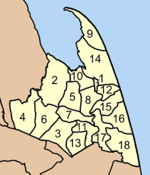
The district is subdivided into 18 subdistricts (tambonTambon
Tambon is a local government unit in Thailand. Below district and province , they form the third administrative subdivision level. As of the 2009 there are 7255 tambon, not including the 169 khwaeng of Bangkok, which are set at the same administrative level, thus every district contains 8-10 tambon...
), which are further subdivided into 133 villages (muban
Muban
Muban is the lowest administrative subdivision of Thailand. Usually translated as village, they are the subdivision of tambon. As of 2008, there are 74944 administrative villages in Thailand. As of the 1990 census, the average village consisted of 144 households or 746 persons.A muban does not...
). Pak Phanang is a town (thesaban mueang) which covers the whole tambon Pak Phanang and parts of tambon Hu Long, Pak Phanang Fang Tawan Tok, Pak Phanang Fang Tawan Ok and Bang Phra. There are further 17 Tambon administrative organizations.
|
 |