
Amphoe Cha-uat
Encyclopedia
Cha-uat is a district (Amphoe
) in the southern part of Nakhon Si Thammarat Province
, southern Thailand
.
, Chulabhorn
, Ron Phibun
, Chaloem Phra Kiat
, Chian Yai
and Hua Sai
of Nakho Si Thammarat Province, Ranot
of Songkhla Province
, Khuan Khanun
and Pa Phayom
of Phattalung Province and Huai Yot
of Trang Province
.
Khao Pu - Khao Ya National Park is located in the Nakhon Si Thammarat mountain range
at the boundary to Phattalung and Trang provinces.
. It was upgraded to a full district on January 1 1953.
), which are further subdivided into 88 villages (muban
). Cha-uat is a township (thesaban tambon) which covers parts of tambon Cha-uat and Tha Pra Cha. There are further 11 Tambon administrative organizations (TAO).
Amphoe
An amphoe is the second level administrative subdivision of Thailand. Usually translated as district, amphoe make up the provinces, and are analogous to a county seat...
) in the southern part of Nakhon Si Thammarat Province
Nakhon Si Thammarat Province
Nakhon Si Thammarat is one of the southern provinces of Thailand, at the eastern shore of the Gulf of Thailand...
, southern Thailand
Southern Thailand
Southern Thailand is a distinct region of Thailand, connected with the Central region by the narrow Kra Isthmus.-Geography:Southern Thailand is located on the Malay Peninsula, with an area around 70,713 km², bounded to the north by Kra Isthmus as the narrowest part of the peninsula. The...
.
Geography
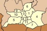
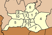
Neighboring districts are (from the west clockwise) Thung SongAmphoe Thung Song
Thung Song is a district in the southwestern part of Nakhon Si Thammarat Province, southern Thailand.-Geography:Neighboring districts are Bang Khan, Thung Yai, Na Bon, Chang Klang, Lan Saka, Ron Phibun, Chulabhorn, Cha-uat of Nakhon Si Thammarat Province, Huai Yot and Ratsada of Trang...
, Chulabhorn
Amphoe Chulabhorn
Chulabhorn is a district of Nakhon Si Thammarat Province, southern Thailand.The district is named in honor of HRH Princess Chulabhorn, the youngest daughter of King Bhumipol Adulyadej, at her 36th birthday.-History:...
, Ron Phibun
Amphoe Ron Phibun
Ron Phibun is a district in the southern part of Nakhon Si Thammarat Province, southern Thailand.-Geography:Neighboring districts are Thung Song, Lan Saka, Phra Phrom, Chaloem Phra Kiat, Cha-uat and Chulabhorn of Nakhon Si Thammarat Province.-Administration:The district is subdivided into 6...
, Chaloem Phra Kiat
Amphoe Chaloem Phra Kiat, Nakhon Si Thammarat Province
Chaloem Phra Kiat is a district of Nakhon Si Thammarat Province, southern Thailand.-History:The district was created on December 5, 1996, together with four other districts named Chaloem Phra Kiat in celebration of the 50th anniversary of King Bhumibol Adulyadej ascension to the throne.The...
, Chian Yai
Amphoe Chian Yai
Chian Yai is a district in the southeastern part of Nakhon Si Thammarat Province, southern Thailand.-Geography:Neighboring districts are Pak Phanang, Hua Sai, Cha-uat and Chaloem Phra Kiat.-History:...
and Hua Sai
Amphoe Hua Sai
Hua Sai is a district in the southeastern part of Nakhon Si Thammarat Province, southern Thailand.-Geography:Neighboring districts are Ranot of Songkhla Province, Khuan Khanun and Pa Phayom of Phattalung Province, Cha-uat, Chian Yai and Pak Phanang of Nakhon Si Thammarat Province...
of Nakho Si Thammarat Province, Ranot
Amphoe Ranot
Ranot is the northernmost district of Songkhla Province, southern Thailand.-Geography:Neighboring districts are Sathing Phra, Krasae Sin of Songkhla Province, Mueang Phatthalung, Khuan Khanun of Phatthalung Province, Cha-uat and Hua Sai of Nakhon Si Thammarat Province...
of Songkhla Province
Songkhla Province
Songkhla is one of the southern provinces of Thailand. Neighboring provinces are Satun, Phatthalung, Nakhon Si Thammarat, Pattani and Yala. To the south it borders Kedah and Perlis of Malaysia....
, Khuan Khanun
Amphoe Khuan Khanun
Khuan Khanun is a district of Phatthalung Province, southern Thailand.-Geography:Neighboring districts are Mueang Phatthalung, Srinagarindra, Si Banphot and Pa Phayom of Phatthalung Province, Cha-uat of Nakhon Si Thammarat Province, and Ranot of Songkhla Province.The Phru Khuan Khi Sian wetlands...
and Pa Phayom
Amphoe Pa Phayom
Pa Phayom is the northernmost district of Phatthalung Province, southern Thailand.-Geography:Neighboring districts are Khuan Khanun, Si Banphot of Phattalung Province, Huai Yot of Trang Province and Cha-uat of Nakhon Si Thammarat Province.-History:The minor district was established on January...
of Phattalung Province and Huai Yot
Amphoe Huai Yot
Huai Yot is a district in the northern part of Trang Province, Thailand.-Geography:Neighboring districts are Ratsada of Trang Province, Thung Song of Nakhon Si Thammarat Province, Pa Phayom, Si Banphot of Phatthalung Province, Mueang Trang, Wang Wiset of Trang Province again and Bang Khan of...
of Trang Province
Trang Province
Trang is one of the southern provinces of Thailand, at the western shore of the Malay Peninsula to the Andaman Sea. Neighboring provinces are Krabi, Nakhon Si Thammarat, Phatthalung and Satun....
.
Khao Pu - Khao Ya National Park is located in the Nakhon Si Thammarat mountain range
Nakhon Si Thammarat mountain range
The Nakhon Si Thammarat mountain range is a mountain range on the Malay peninsula in southern Thailand, running in a north-south direction. This mountain chain is also sometimes named Banthat mountain range , a name which is however also used to refer to the Chanthaburi mountain...
at the boundary to Phattalung and Trang provinces.
History
The minor district (King Amphoe) was created in 1923, when it was split from Ron Phibun districtAmphoe Ron Phibun
Ron Phibun is a district in the southern part of Nakhon Si Thammarat Province, southern Thailand.-Geography:Neighboring districts are Thung Song, Lan Saka, Phra Phrom, Chaloem Phra Kiat, Cha-uat and Chulabhorn of Nakhon Si Thammarat Province.-Administration:The district is subdivided into 6...
. It was upgraded to a full district on January 1 1953.
Administration
The district is subdivided into 11 subdistricts (tambonTambon
Tambon is a local government unit in Thailand. Below district and province , they form the third administrative subdivision level. As of the 2009 there are 7255 tambon, not including the 169 khwaeng of Bangkok, which are set at the same administrative level, thus every district contains 8-10 tambon...
), which are further subdivided into 88 villages (muban
Muban
Muban is the lowest administrative subdivision of Thailand. Usually translated as village, they are the subdivision of tambon. As of 2008, there are 74944 administrative villages in Thailand. As of the 1990 census, the average village consisted of 144 households or 746 persons.A muban does not...
). Cha-uat is a township (thesaban tambon) which covers parts of tambon Cha-uat and Tha Pra Cha. There are further 11 Tambon administrative organizations (TAO).
|
 |