
Illawong, New South Wales
Encyclopedia
Illawong is a suburb
in southern
Sydney
, in the state of New South Wales
, Australia
. Illawong is located 27 kilometres south-west of the Sydney Central Business District
, in the local government area of the Sutherland Shire
in the area commonly called Menai. The post code is 2234, which is also assigned to the contiguous suburbs of Menai
, Bangor
and Alfords Point
.
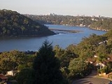
Illawong sits between the southern shore of the Georges River
and the northern shore of the Woronora River
. Illawong consists mainly of residential homes, a nursing home, a primary school and a small shopping centre.
tribes who left remnants of their lives in many middens, rock carvings and cave paintings.
Captain John Hunter (1731–1821) was the first European to explore the area. In 1789, Hunter sailed through the Georges and Woronora Rivers. In 1795-6, with Matthew Flinders
and George Bass
, Hunter explored further up the Georges River and declared the area of Bankstown.
Construction of Old Illawarra Road took place between 1843 to 1845 and was inspected by Major Thomas Mitchell, it being one of the last public works completed by convicts. The construction allowed the new route to be about 32 kilometres shorter towards the South Coast. At the southern end of the district Major Mitchell took the road across the ford at the head of the Woronora River, naming the ford "Pass of Sabugal", possibly due to the resemblance in scenery of the north-eastern frontier of Portugal.
In the 1890s Menai was a farming area and Illawong, which was then known as East Menai, was an area where wealthy people of Sydney built holiday homes and weekenders.
This area was ravaged in the 1994 Eastern seaboard fires
, which also caused destruction in the suburbs of Alfords Point
, Menai
and Como
. Illawong is considered to be a bushfire prone area.
and many specialty shops including butcher, chemist, newsagency, medical centre and several restaurants.
, Sutherland
and Bankstown
.
Suburb
The word suburb mostly refers to a residential area, either existing as part of a city or as a separate residential community within commuting distance of a city . Some suburbs have a degree of administrative autonomy, and most have lower population density than inner city neighborhoods...
in southern
Southern Sydney
This article refers to an area the same as a combination of St George and SutherlandSouthern Sydney is a general term which is used to describe the southern metropolitan area of Sydney, in the state of New South Wales, Australia....
Sydney
Sydney
Sydney is the most populous city in Australia and the state capital of New South Wales. Sydney is located on Australia's south-east coast of the Tasman Sea. As of June 2010, the greater metropolitan area had an approximate population of 4.6 million people...
, in the state of New South Wales
New South Wales
New South Wales is a state of :Australia, located in the east of the country. It is bordered by Queensland, Victoria and South Australia to the north, south and west respectively. To the east, the state is bordered by the Tasman Sea, which forms part of the Pacific Ocean. New South Wales...
, Australia
Australia
Australia , officially the Commonwealth of Australia, is a country in the Southern Hemisphere comprising the mainland of the Australian continent, the island of Tasmania, and numerous smaller islands in the Indian and Pacific Oceans. It is the world's sixth-largest country by total area...
. Illawong is located 27 kilometres south-west of the Sydney Central Business District
Sydney central business district
The Sydney central business district is the main commercial centre of Sydney, New South Wales, Australia. It extends southwards for about 3 kilometres from Sydney Cove, the point of first European settlement. Its north–south axis runs from Circular Quay in the north to Central railway station in...
, in the local government area of the Sutherland Shire
Sutherland Shire
The Sutherland Shire is a Local Government Area in the Southern Sydney region of Sydney, Australia. Geographically, it is the area to the south of Botany Bay and the Georges River...
in the area commonly called Menai. The post code is 2234, which is also assigned to the contiguous suburbs of Menai
Menai, New South Wales
Menai is a suburb in southern Sydney, in the state of New South Wales, Australia. Menai is located 29 kilometres south of the Sydney central business district in the local government area of the Sutherland Shire.-History:...
, Bangor
Bangor, New South Wales
Bangor is a suburb in southern Sydney, in the state of New South Wales, Australia. Bangor is located 28 kilometres south of the Sydney central business district, in the local government area of the Sutherland Shire in the area commonly called Menai...
and Alfords Point
Alfords Point, New South Wales
Alfords Point is a suburb in southern Sydney, in the state of New South Wales, Australia. Alfords Point is located 28 kilometres south of the Sydney central business district, in the local government area of the Sutherland Shire in the area commonly called Menai...
.
Illawong sits between the southern shore of the Georges River
Georges River
The Georges River is a waterway in the state of New South Wales in Australia. It rises to the south-west of Sydney near the coal mining town of Appin, and then flows north past Campbelltown, roughly parallel to the Main South Railway...
and the northern shore of the Woronora River
Woronora River
The Woronora River flows north from near Helensburgh into the Georges River between Como and Illawong.- Crossings :The river is crossed by high level and low level road bridges and a footbridge in Woronora, New South Wales...
. Illawong consists mainly of residential homes, a nursing home, a primary school and a small shopping centre.
History
Illawong is an Aboriginal word meaning between two waters, referring to the Georges and Woronora Rivers. Illawong was originally inhabited by the Tharawal and/or EoraEora
The Eora are the Aboriginal people of the Sydney area, south to the Georges River, north to the Hawkesbury River, and west to Parramatta. The indigenous people used this word to describe where they came from to the British. "Eora" was then used by the British to refer to those Aboriginal people...
tribes who left remnants of their lives in many middens, rock carvings and cave paintings.
Captain John Hunter (1731–1821) was the first European to explore the area. In 1789, Hunter sailed through the Georges and Woronora Rivers. In 1795-6, with Matthew Flinders
Matthew Flinders
Captain Matthew Flinders RN was one of the most successful navigators and cartographers of his age. In a career that spanned just over twenty years, he sailed with Captain William Bligh, circumnavigated Australia and encouraged the use of that name for the continent, which had previously been...
and George Bass
George Bass
George Bass was a British naval surgeon and explorer of Australia.-Early years:He was born on 30 January 1771 at Aswarby, a hamlet near Sleaford, Lincolnshire, the son of a tenant farmer, George Bass, and a local beauty named Sarah Nee Newman. His father died in 1777 when Bass was 6...
, Hunter explored further up the Georges River and declared the area of Bankstown.
Construction of Old Illawarra Road took place between 1843 to 1845 and was inspected by Major Thomas Mitchell, it being one of the last public works completed by convicts. The construction allowed the new route to be about 32 kilometres shorter towards the South Coast. At the southern end of the district Major Mitchell took the road across the ford at the head of the Woronora River, naming the ford "Pass of Sabugal", possibly due to the resemblance in scenery of the north-eastern frontier of Portugal.
In the 1890s Menai was a farming area and Illawong, which was then known as East Menai, was an area where wealthy people of Sydney built holiday homes and weekenders.
This area was ravaged in the 1994 Eastern seaboard fires
1994 Eastern seaboard fires
The 1994 Eastern seaboard fires were bushfires in New South Wales, Australia between 27 December 1993 and 16 January 1994 were widespread along the NSW coast from Bega to the Queensland border and inland as far as Bathurst. Over 80 separate fires encouraged by extreme hot dry and windy conditions...
, which also caused destruction in the suburbs of Alfords Point
Alfords Point, New South Wales
Alfords Point is a suburb in southern Sydney, in the state of New South Wales, Australia. Alfords Point is located 28 kilometres south of the Sydney central business district, in the local government area of the Sutherland Shire in the area commonly called Menai...
, Menai
Menai, New South Wales
Menai is a suburb in southern Sydney, in the state of New South Wales, Australia. Menai is located 29 kilometres south of the Sydney central business district in the local government area of the Sutherland Shire.-History:...
and Como
Como, New South Wales
Como is a suburb in southern Sydney, in the state of New South Wales, Australia. Como is located 27 kilometres south of the Sydney central business district in the local government area of the Sutherland Shire. The postcode is 2226, which it shares with neighbouring Jannali and Bonnet Bay...
. Illawong is considered to be a bushfire prone area.
Commercial area
Illawong Village shopping centre sits between Fowler Road and Hobart Place. Originally a small collection of shops, the shopping centre was rebuilt in 2007. Illawong Village features a Coles supermarket, LiquorlandLiquorLAND
Liquorland is an Australian liquor chain owned by Wesfarmers. Liquorland is one of three brands within Wesfarmers' Coles division., along with fine-wine focussed Vintage Cellars and the larger discount format 1st Choice Liquor Superstore...
and many specialty shops including butcher, chemist, newsagency, medical centre and several restaurants.
Transport
Major roads and streets include Fowler Road and Moreton Road. Veolia Transport has regular bus services which links Illawong to surrounding centres such as MenaiMenai, New South Wales
Menai is a suburb in southern Sydney, in the state of New South Wales, Australia. Menai is located 29 kilometres south of the Sydney central business district in the local government area of the Sutherland Shire.-History:...
, Sutherland
Sutherland, New South Wales
Sutherland is a suburb in southern Sydney, in the state of New South Wales, Australia. Sutherland is located 26 kilometres south of the Sydney central business district and is the administrative centre for the local government area of the Sutherland Shire....
and Bankstown
Bankstown, New South Wales
Bankstown is a suburb of south-western Sydney, in the state of New South Wales, Australia. Bankstown is located 20 kilometres south-west of the Sydney central business district and is the administrative centre of the local government area of the City of Bankstown.-History:Prior to European...
.
Schools
- Illawong Primary School
- Tharawal Primary School
- Menai High SchoolMenai High SchoolMenai High School is a secondary school located in Menai, a suburb in Sydney's Sutherland Shire, New South Wales, Australia.The operation of the school is underpinned by the following beliefs and values:...
is the major public secondary co-educational high school servicing the Menai Area.