
Albion, Victoria
Encyclopedia
Albion is a small suburb in Melbourne
, Victoria
, Australia
, 13 km west from Melbourne's central business district
. It is completely surrounded by other parts of Sunshine
except for Ardeer
which lies to Albion's due west across Kororoit Creek
. Its Local Government Area is the City of Brimbank
. It is bordered on the north by the Western Highway
, the south by Forrest Street, the west by Kororoit Creek
and the east by Anderson Road.
being an ancient name for the island of Great Britain
. Albion station opened on January 5, 1860 as Albion and Darlington but closed a year later. It was not until 1919 that a new station was opened on the same site with the name Albion station.
In March 1885 the Albion Quarrying Company began its operations in the area
It was H. V. McKay of Sunshine Harvester Works
fame who bought land to develop a residential community for his workers in first decades on the 20th century. His concept for Sunshine was the Sunshine Estate: a community developed according to the ideals of the Garden city movement
, an influential town planning movement of the late 19th and early 20th centuries. This area was mainly in what is now called Albion. McKay's own residence, The Gables, was in Talmage Street (where the court The Gables now is) until it was demolished.
s and 1940s weatherboard houses many of which were built by H. V. McKay as part of his Sunshine Estate Garden city
community.
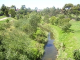
Kororoit Creek runs through Albion along which runs the Kororoit Creek Trail
. In October 2007 Premier
John Brumby
announced that funding would be provided to extend the Kororoit Creek Trail to the Federation Trail
linking the two bike paths.
Stony Creek lies in the eastern part of Albion, close to Anderson Road. The creek's environmental state in Albion and Sunshine is currently very poor; it is best characterised as a concrete stormwater drain
for this section of its course.
on the Sydenham line lies in the Metcard
zones 1+2 overlap.
. The Kororoit Creek Trail
runs along Albion's western perimeter.
team. They compete in the Western Region Football League
.
Other sports clubs include:
Melbourne
Melbourne is the capital and most populous city in the state of Victoria, and the second most populous city in Australia. The Melbourne City Centre is the hub of the greater metropolitan area and the Census statistical division—of which "Melbourne" is the common name. As of June 2009, the greater...
, Victoria
Victoria (Australia)
Victoria is the second most populous state in Australia. Geographically the smallest mainland state, Victoria is bordered by New South Wales, South Australia, and Tasmania on Boundary Islet to the north, west and south respectively....
, Australia
Australia
Australia , officially the Commonwealth of Australia, is a country in the Southern Hemisphere comprising the mainland of the Australian continent, the island of Tasmania, and numerous smaller islands in the Indian and Pacific Oceans. It is the world's sixth-largest country by total area...
, 13 km west from Melbourne's central business district
Melbourne city centre
Melbourne City Centre is an area of Melbourne in Victoria, Australia. It is not to be confused with the larger local government area of the City of Melbourne...
. It is completely surrounded by other parts of Sunshine
Sunshine, Victoria
Sunshine is a suburb of Melbourne, Victoria, Australia lying 11 to 13 km west of the CBD. Its Local Government Area is the City of Brimbank. At the 2006 Census, Sunshine had a population of 8,070.-History:...
except for Ardeer
Ardeer, Victoria
Ardeer is a suburb in Melbourne, Victoria, Australia, 16 km west from Melbourne's central business district. Its Local Government Area is the City of Brimbank. At the 2006 Census, Ardeer had a population of 2582....
which lies to Albion's due west across Kororoit Creek
Kororoit Creek
Kororoit Creek is a major waterway of over 80 km in length in the north-west and western parts of Melbourne. Its headwaters are north of Sunbury at 400m above sea level in ordovician geology...
. Its Local Government Area is the City of Brimbank
City of Brimbank
The City of Brimbank is a Local Government Area located within the metropolitan area of Melbourne, Victoria, Australia. It comprises the western suburbs between 10 and 20 km west and northwest from the Melbourne city centre.It has an area of 123 km²...
. It is bordered on the north by the Western Highway
Western Highway
Western Highway may refer to:*Western Highway, Victoria in Australia*Western Highway...
, the south by Forrest Street, the west by Kororoit Creek
Kororoit Creek
Kororoit Creek is a major waterway of over 80 km in length in the north-west and western parts of Melbourne. Its headwaters are north of Sunbury at 400m above sea level in ordovician geology...
and the east by Anderson Road.
History
The area was originally called Darlington, from at least 1860 to about 1890. The area originally known as Albion was directly west of Duke Street, as can be noted by the many streets there named after English counties and placenames - AlbionAlbion
Albion is the oldest known name of the island of Great Britain. Today, it is still sometimes used poetically to refer to the island or England in particular. It is also the basis of the Scottish Gaelic name for Scotland, Alba...
being an ancient name for the island of Great Britain
Great Britain
Great Britain or Britain is an island situated to the northwest of Continental Europe. It is the ninth largest island in the world, and the largest European island, as well as the largest of the British Isles...
. Albion station opened on January 5, 1860 as Albion and Darlington but closed a year later. It was not until 1919 that a new station was opened on the same site with the name Albion station.
In March 1885 the Albion Quarrying Company began its operations in the area
It was H. V. McKay of Sunshine Harvester Works
Sunshine Harvester Works
The Sunshine Harvester works, was an Australia factory operated by industrialist H. V. McKay. Having established an agricultural implement works in Ballarat he moved his factory and many of his employees to Braybrook Junction, in 1906,where he had earlier purchased the Braybrook Implement Works...
fame who bought land to develop a residential community for his workers in first decades on the 20th century. His concept for Sunshine was the Sunshine Estate: a community developed according to the ideals of the Garden city movement
Garden city movement
The garden city movement is a method of urban planning that was initiated in 1898 by Sir Ebenezer Howard in the United Kingdom. Garden cities were intended to be planned, self-contained communities surrounded by "greenbelts" , containing proportionate areas of residences, industry and...
, an influential town planning movement of the late 19th and early 20th centuries. This area was mainly in what is now called Albion. McKay's own residence, The Gables, was in Talmage Street (where the court The Gables now is) until it was demolished.
Today
At the 2006 Census, Albion had a population of 3,763. Albion has many period homes such as California bungalowCalifornia Bungalow
California bungalows, known as Californian bungalows in Australia and are commonly called simply bungalows in America, are a form of residential structure that were widely popular across America and, to some extent, the world around the years 1910 to 1939.-Exterior features:Bungalows are 1 or 1½...
s and 1940s weatherboard houses many of which were built by H. V. McKay as part of his Sunshine Estate Garden city
Garden city movement
The garden city movement is a method of urban planning that was initiated in 1898 by Sir Ebenezer Howard in the United Kingdom. Garden cities were intended to be planned, self-contained communities surrounded by "greenbelts" , containing proportionate areas of residences, industry and...
community.
Kororoit Creek runs through Albion along which runs the Kororoit Creek Trail
Kororoit Creek Trail
The Kororoit Creek Trail is a shared use path for cyclists and pedestrians, which follows the Kororoit Creek in the inner western suburbs of Melbourne, Victoria, Australia....
. In October 2007 Premier
Premiers of Victoria
The Premier of Victoria is the leader of the government in the Australian state of Victoria. The Premier is appointed by the Governor of Victoria, and is the leader of the political party able to secure a majority in the Legislative Assembly....
John Brumby
John Brumby
John Mansfield Brumby , is an Australian Labor Party politician who was Premier of Victoria from 2007 to 2010. He became Premier after the resignation of Steve Bracks. He also served as the Minister for Veterans' Affairs and the Minister for Multicultural Affairs. He contested his first election...
announced that funding would be provided to extend the Kororoit Creek Trail to the Federation Trail
Federation Trail
The Federation Trail is a shared use path for cyclists and pedestrians, which mainly follows the old "Outfall Sewer" through the western suburbs of Melbourne, Victoria, Australia....
linking the two bike paths.
Stony Creek lies in the eastern part of Albion, close to Anderson Road. The creek's environmental state in Albion and Sunshine is currently very poor; it is best characterised as a concrete stormwater drain
Storm drain
A storm drain, storm sewer , stormwater drain or drainage well system or simply a drain or drain system is designed to drain excess rain and ground water from paved streets, parking lots, sidewalks, and roofs. Storm drains vary in design from small residential dry wells to large municipal systems...
for this section of its course.
Trains
The Albion railway stationAlbion railway station, Melbourne
Albion is a railway station in Melbourne, Victoria, Australia, located on the border of the suburbs of Sunshine and Albion, Victoria, on the Sydenham railway line...
on the Sydenham line lies in the Metcard
Metcard
"OneLink" redirects here. For the computer/cable company, see OneLink Communications.Metcard is the brand name of an integrated ticketing system used to access public transport in Melbourne, Australia. It is a universal ticket which allows users to ride on the city's Metlink network, consisting of...
zones 1+2 overlap.
Buses
Metropolitan buses service the suburb and Albion station. These include:- 215 Caroline SpringsCaroline Springs, VictoriaCaroline Springs is a suburb in Melbourne, Victoria, Australia located 25 km west from Melbourne's central business district on Kororoit Creek. Its Local Government Area is the Shire of Melton. At the 2006 Census, it had a population of 10,880....
– Highpoint SCHighpoint Shopping CentreHighpoint Shopping Centre is a major shopping centre located in Maribyrnong, Victoria, in the western suburbs of Melbourne, Victoria, Australia. The centre has over 400 stores including a four-level Myer department store, Target, Big W, Harris Scarfe, Safeway supermarket, Best and Less, Rebel...
via Albion RS, Burnside SC (every day). Operated by Melbourne Bus LinkMelbourne Bus LinkMelbourne Bus Link is a Melbourne bus company, owned by a joint partnership between Dyson's and Reservoir Bus Companies to run government operated routes covering the western and south east regions of Melbourne.-Routes:...
. - 216 Caroline SpringsCaroline Springs, VictoriaCaroline Springs is a suburb in Melbourne, Victoria, Australia located 25 km west from Melbourne's central business district on Kororoit Creek. Its Local Government Area is the Shire of Melton. At the 2006 Census, it had a population of 10,880....
– Brighton Beach via Deer Park West, Sunshine, Footscray, Melbourne, St Kilda Road, Prahran, and Elsternwick (every day). Operated by Melbourne Bus LinkMelbourne Bus LinkMelbourne Bus Link is a Melbourne bus company, owned by a joint partnership between Dyson's and Reservoir Bus Companies to run government operated routes covering the western and south east regions of Melbourne.-Routes:...
. - 400 SunshineSunshine, VictoriaSunshine is a suburb of Melbourne, Victoria, Australia lying 11 to 13 km west of the CBD. Its Local Government Area is the City of Brimbank. At the 2006 Census, Sunshine had a population of 8,070.-History:...
- LavertonLaverton, VictoriaLaverton is a suburb in Melbourne, Victoria, Australia, 17 km south-west from Melbourne's central business district. Its Local Government Area are the Cities of Hobsons Bay and Wyndham. At the 2006 Census, Laverton had a population of 4508.-History:...
via Deer Park RS, Dame Phyllis Frost Centre, Metropolitan Remand Centre, and Port Phillip Prison (every day). Operated by Sita Bus Lines and WestransWestransWestrans is the brand under which ComfortDelGro Cabcharge markets its bus services to the western suburbs of Melbourne, Victoria, Australia.-Routes:Routes operated under Westrans Sunshine...
. - 451 SunshineSunshine, VictoriaSunshine is a suburb of Melbourne, Victoria, Australia lying 11 to 13 km west of the CBD. Its Local Government Area is the City of Brimbank. At the 2006 Census, Sunshine had a population of 8,070.-History:...
- Deer Park North via Deer Park RS (every day). Operated by Sita Bus Lines. - 456 SunshineSunshine, VictoriaSunshine is a suburb of Melbourne, Victoria, Australia lying 11 to 13 km west of the CBD. Its Local Government Area is the City of Brimbank. At the 2006 Census, Sunshine had a population of 8,070.-History:...
– Woodgrove SC via Albion RS, Burnside SC, Caroline Springs, Melton (every day). Operated by Sita Bus Lines. - 903 AltonaAltona, VictoriaAltona is a suburb in Melbourne, Victoria, Australia, 13 km south-west from Melbourne's central business district. Its Local Government Area is the City of Hobsons Bay. At the 2006 Census, Altona had a population of 9685....
– Mordialloc SC via Essendon, Northland SC, Box Hill, Chadstone SC (every day). Operated by Ventura Bus LinesVentura Bus LinesVentura is a privately owned bus and coach operator in Melbourne, Victoria, Australia. Today the largest private Melbourne bus company, and operates a number of bus routes under contract from the Victorian State Government. The company purchased National Bus Company for A$45 million, and the Mount...
.
Cycling
Cyclists in Albion are represented by BrimBUG, the Brimbank Bicycle User GroupBicycle User Group
A Bicycle User Group is a group set up to promote cycling issues in, for example, a place of employment or a local government area...
. The Kororoit Creek Trail
Kororoit Creek Trail
The Kororoit Creek Trail is a shared use path for cyclists and pedestrians, which follows the Kororoit Creek in the inner western suburbs of Melbourne, Victoria, Australia....
runs along Albion's western perimeter.
Education
- Albion Primary School (est 1926)
- St Theresa's Catholic Primary School
- Albion Kindergarten
Sporting facilities
The Albion Cats are the local Australian rules footballAustralian rules football
Australian rules football, officially known as Australian football, also called football, Aussie rules or footy is a sport played between two teams of 22 players on either...
team. They compete in the Western Region Football League
Western Region Football League
The Western Region Football League is an Australian rules football semi-professional league, based in the western suburbs of Melbourne, for both seniors and juniors.-History:The league was formed in 1931, as the Footscray District Football League...
.
Other sports clubs include:
- Sunshine Baseball Club
- Sunshine Bowls Club
- Polish Sports Centre
- Sunshine United Cricket Club
- Ace GoKarts
- Albion Tennis Club
Religious sites
- St Theresa's Catholic Church
- Slovakian Baptist Church
- Assemblies of God Church
See also
- City of SunshineCity of SunshineThe City of Sunshine was a Local Government Area located about west of Melbourne, the state capital of Victoria, Australia. The city covered an area of , and existed from 1860 until 1994.-History:...
- the former local government area of which Albion was a part. - Albion railway station, MelbourneAlbion railway station, MelbourneAlbion is a railway station in Melbourne, Victoria, Australia, located on the border of the suburbs of Sunshine and Albion, Victoria, on the Sydenham railway line...
- Kororoit CreekKororoit CreekKororoit Creek is a major waterway of over 80 km in length in the north-west and western parts of Melbourne. Its headwaters are north of Sunbury at 400m above sea level in ordovician geology...
- Kororoit Creek TrailKororoit Creek TrailThe Kororoit Creek Trail is a shared use path for cyclists and pedestrians, which follows the Kororoit Creek in the inner western suburbs of Melbourne, Victoria, Australia....