
Kororoit Creek Trail
Encyclopedia
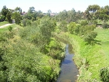
The Kororoit Creek Trail is a shared use path for cyclists and pedestrians, which follows the Kororoit Creek
in the inner western suburbs of Melbourne
, Victoria
, Australia
.
The name "Kororoit" is thought to have come from an Aboriginal word meaning "male kangaroo" although this has not been confirmed.
The interrupted upper half is located in Burnside
and Deer Park
.
The uninterrupted upper section starts in Ardeer
and proceeds to Brooklyn
the lower half is located in Altona
.
, on to Burnside
continuing through to Albanvale
and then Deer Park
(approx 10 km).
The trail starts as a concrete path in Caroline Springs, where Caroline Springs Boulevarde crosses the creek. Some 2 km later use the road section from Westwood Drive to Bilungah Place. This leads to a gravel section and a ford to access the east side of the creek. A 1 km dirt track leads to a small footbridge near the Deer Park Secondary College at Deer Park. If the ford is flooded, a nearby road route can be used to access this footbridge instead.
Navigation is then straightforward with sealed concrete paths on both sides of the creek arriving at Station Road (approx 800m).
After an easy road crossing at Station Road the path continues on the south bank along Gurnung Drv and crosses to the north bank, then through Cairnlea
to Cairnlea Drive (approx 700m). From here pedestrians cross the Western Highway
and then proceed east to Moore Park in Ardeer (approx 400m) to the Western Ring Road Trail
.
to Albion
, Sunshine
and then onto Brooklyn
(approx 4 km). The trail passes very close to Sunshine station
and also has easy access to the Western Ring Road Trail
at Moore Park and more indirectly to the Federation Trail
in Brooklyn.
goes through Altona Coastal Park
- site of the old Williamstown Racecourse. A lone palm
stands guard over the remains of the old grandstand. North of the park, at the ford over Racecourse Road and also at the south end of the park, trails split off that lead to a single path, that heads westerly towards Millers Road. Nearby was the old Williamstown Racecourse railway station.
At Millers Rd cross the road to the serenity of Cherry Lake
. A 3.7 km path circumnavigates the lake. On the way birdlife including pelicans
can be seen. It makes for stark contrast in this heavily industrialised area and is well worth the trip.
and the upper and lower sections of the Kororoit Creek Trail will be directly linked. As of 2010, connection of the two sections will be somewhat more complicated by the construction of WestLink
, that is likely to intercept the path, just south of Learmouth Crescent. Once the upper and lower paths are joined, those using the trail will be able to travel along an uninterrupted pathway from Ardeer
to Port Phillip Bay. (Approx 11 km)
. The southern end of the upper half is a dead-end near Learmonth Crt.
The northern end of the lower half is a dead end at Cherry Lake. The southern end of the lower half connects to Hobsons Bay Coastal Trail
.
Upper:
North end at 37.738450°S 144.738725°E.
South end at 37.803048°S 144.832414°E.
Lower:
North end at 37.858104°S 144.826533°E.
South end at 37.858477°S 144.850282°E.
Kororoit Creek
Kororoit Creek is a major waterway of over 80 km in length in the north-west and western parts of Melbourne. Its headwaters are north of Sunbury at 400m above sea level in ordovician geology...
in the inner western suburbs of Melbourne
Melbourne
Melbourne is the capital and most populous city in the state of Victoria, and the second most populous city in Australia. The Melbourne City Centre is the hub of the greater metropolitan area and the Census statistical division—of which "Melbourne" is the common name. As of June 2009, the greater...
, Victoria
Victoria (Australia)
Victoria is the second most populous state in Australia. Geographically the smallest mainland state, Victoria is bordered by New South Wales, South Australia, and Tasmania on Boundary Islet to the north, west and south respectively....
, Australia
Australia
Australia , officially the Commonwealth of Australia, is a country in the Southern Hemisphere comprising the mainland of the Australian continent, the island of Tasmania, and numerous smaller islands in the Indian and Pacific Oceans. It is the world's sixth-largest country by total area...
.
The name "Kororoit" is thought to have come from an Aboriginal word meaning "male kangaroo" although this has not been confirmed.
The interrupted upper half is located in Burnside
Burnside, Victoria
Burnside is a suburb in Melbourne, Victoria, Australia, 22 km west from Melbourne's central business district. Its Local Government Area is the Shire of Melton...
and Deer Park
Deer Park, Victoria
Deer Park is a suburb in Melbourne, Victoria, Australia, 17 km west from Melbourne's central business district. Its Local Government Area is the City of Brimbank...
.
The uninterrupted upper section starts in Ardeer
Ardeer, Victoria
Ardeer is a suburb in Melbourne, Victoria, Australia, 16 km west from Melbourne's central business district. Its Local Government Area is the City of Brimbank. At the 2006 Census, Ardeer had a population of 2582....
and proceeds to Brooklyn
Brooklyn, Victoria
Brooklyn is a suburb in Melbourne, Victoria, Australia, 10 km west from Melbourne's central business district. Its Local Government Area are the Cities of Hobsons Bay and Brimbank. At the 2006 Census, Brooklyn had a population of 1583.-Industry:...
the lower half is located in Altona
Altona, Victoria
Altona is a suburb in Melbourne, Victoria, Australia, 13 km south-west from Melbourne's central business district. Its Local Government Area is the City of Hobsons Bay. At the 2006 Census, Altona had a population of 9685....
.
Upper section interrupted
The trail starts in Caroline SpringsCaroline Springs, Victoria
Caroline Springs is a suburb in Melbourne, Victoria, Australia located 25 km west from Melbourne's central business district on Kororoit Creek. Its Local Government Area is the Shire of Melton. At the 2006 Census, it had a population of 10,880....
, on to Burnside
Burnside, Victoria
Burnside is a suburb in Melbourne, Victoria, Australia, 22 km west from Melbourne's central business district. Its Local Government Area is the Shire of Melton...
continuing through to Albanvale
Albanvale, Victoria
Albanvale is a suburb in Melbourne, Victoria, Australia, 19 km west from Melbourne's central business district. Its Local Government Area is the City of Brimbank. At the 2006 Census, Albanvale had a population of 5576....
and then Deer Park
Deer Park, Victoria
Deer Park is a suburb in Melbourne, Victoria, Australia, 17 km west from Melbourne's central business district. Its Local Government Area is the City of Brimbank...
(approx 10 km).
The trail starts as a concrete path in Caroline Springs, where Caroline Springs Boulevarde crosses the creek. Some 2 km later use the road section from Westwood Drive to Bilungah Place. This leads to a gravel section and a ford to access the east side of the creek. A 1 km dirt track leads to a small footbridge near the Deer Park Secondary College at Deer Park. If the ford is flooded, a nearby road route can be used to access this footbridge instead.
Navigation is then straightforward with sealed concrete paths on both sides of the creek arriving at Station Road (approx 800m).
After an easy road crossing at Station Road the path continues on the south bank along Gurnung Drv and crosses to the north bank, then through Cairnlea
Cairnlea, Victoria
Cairnlea is a suburb in Melbourne, Victoria, Australia, 17 km north-west from Melbourne's central business district. Its Local Government Area is the City of Brimbank...
to Cairnlea Drive (approx 700m). From here pedestrians cross the Western Highway
Western Highway
Western Highway may refer to:*Western Highway, Victoria in Australia*Western Highway...
and then proceed east to Moore Park in Ardeer (approx 400m) to the Western Ring Road Trail
Western Ring Road Trail
The Western Ring Road Trail is a shared use path for cyclists and pedestrians that bridges the northern suburbs and follows the Western Ring Road...
.
Upper section uninterrupted
The trail then runs directly and uninterrupted from Moore Park, ArdeerArdeer, Victoria
Ardeer is a suburb in Melbourne, Victoria, Australia, 16 km west from Melbourne's central business district. Its Local Government Area is the City of Brimbank. At the 2006 Census, Ardeer had a population of 2582....
to Albion
Albion, Victoria
Albion is a small suburb in Melbourne, Victoria, Australia, 13 km west from Melbourne's central business district. It is completely surrounded by other parts of Sunshine except for Ardeer which lies to Albion's due west across Kororoit Creek. Its Local Government Area is the City of Brimbank...
, Sunshine
Sunshine, Victoria
Sunshine is a suburb of Melbourne, Victoria, Australia lying 11 to 13 km west of the CBD. Its Local Government Area is the City of Brimbank. At the 2006 Census, Sunshine had a population of 8,070.-History:...
and then onto Brooklyn
Brooklyn, Victoria
Brooklyn is a suburb in Melbourne, Victoria, Australia, 10 km west from Melbourne's central business district. Its Local Government Area are the Cities of Hobsons Bay and Brimbank. At the 2006 Census, Brooklyn had a population of 1583.-Industry:...
(approx 4 km). The trail passes very close to Sunshine station
Sunshine railway station, Melbourne
Sunshine is a railway station in Melbourne, Victoria, Australia, located in the suburb of Sunshine, on the Sydenham railway line. It is the junction for the line west to Ballarat...
and also has easy access to the Western Ring Road Trail
Western Ring Road Trail
The Western Ring Road Trail is a shared use path for cyclists and pedestrians that bridges the northern suburbs and follows the Western Ring Road...
at Moore Park and more indirectly to the Federation Trail
Federation Trail
The Federation Trail is a shared use path for cyclists and pedestrians, which mainly follows the old "Outfall Sewer" through the western suburbs of Melbourne, Victoria, Australia....
in Brooklyn.
Lower section
The Hobsons Bay Coastal TrailHobsons Bay Coastal Trail
The Hobsons Bay Coastal Trail is a shared use path for cyclists and pedestrians, which follows the coast line of Hobsons Bay in the inner western suburbs in Melbourne, Victoria, Australia. The trail forms part of the western half of the Bayside Trail which encircles Port Phillip...
goes through Altona Coastal Park
Altona Coastal Park
Altona Coastal Park, a 70 hectares intertidal and salt marsh area located 11 km from Melbourne CBD in the western suburb of Altona, is an important recreational and nature conservation area, providing habitats for a large biodiversity of flora and fauna...
- site of the old Williamstown Racecourse. A lone palm
Canary Island Date Palm
Phoenix canariensis is a species in the palm family Arecaceae, native to the Canary Islands. It is a relative of Phoenix dactylifera, the true date palm....
stands guard over the remains of the old grandstand. North of the park, at the ford over Racecourse Road and also at the south end of the park, trails split off that lead to a single path, that heads westerly towards Millers Road. Nearby was the old Williamstown Racecourse railway station.
At Millers Rd cross the road to the serenity of Cherry Lake
Cherry Lake (Victoria)
Cherry Lake is part of historical coastal wetlands in Altona, a suburb of Melbourne, Australia. The wetlands were converted to a lake with construction of retaining walls, levees, and flow channels...
. A 3.7 km path circumnavigates the lake. On the way birdlife including pelicans
Australian Pelican
The Australian Pelican is a large water bird, widespread on the inland and coastal waters of Australia and New Guinea, also in Fiji, parts of Indonesia and as a vagrant to New Zealand.-Taxonomy:...
can be seen. It makes for stark contrast in this heavily industrialised area and is well worth the trip.
Future expansion
the path is only complete in two distinct sections, 5.7 km apart. The upper section is to be extended from Leamonth Crescent to Princess Hwy as announced in October 2007. Thus the Kororoit Creek Trail will be linked to the Federation TrailFederation Trail
The Federation Trail is a shared use path for cyclists and pedestrians, which mainly follows the old "Outfall Sewer" through the western suburbs of Melbourne, Victoria, Australia....
and the upper and lower sections of the Kororoit Creek Trail will be directly linked. As of 2010, connection of the two sections will be somewhat more complicated by the construction of WestLink
Westlink
Westlink or West-link could refer to:*Westlink M7, an urban freeway connecting the northern and southern suburbs of Sydney, Australia.*Westlink, the A12 dual-carriageway through Belfast, Northern Ireland....
, that is likely to intercept the path, just south of Learmouth Crescent. Once the upper and lower paths are joined, those using the trail will be able to travel along an uninterrupted pathway from Ardeer
Ardeer, Victoria
Ardeer is a suburb in Melbourne, Victoria, Australia, 16 km west from Melbourne's central business district. Its Local Government Area is the City of Brimbank. At the 2006 Census, Ardeer had a population of 2582....
to Port Phillip Bay. (Approx 11 km)
Connections
The northern end of the upper half connects to Western Ring Road TrailWestern Ring Road Trail
The Western Ring Road Trail is a shared use path for cyclists and pedestrians that bridges the northern suburbs and follows the Western Ring Road...
. The southern end of the upper half is a dead-end near Learmonth Crt.
The northern end of the lower half is a dead end at Cherry Lake. The southern end of the lower half connects to Hobsons Bay Coastal Trail
Hobsons Bay Coastal Trail
The Hobsons Bay Coastal Trail is a shared use path for cyclists and pedestrians, which follows the coast line of Hobsons Bay in the inner western suburbs in Melbourne, Victoria, Australia. The trail forms part of the western half of the Bayside Trail which encircles Port Phillip...
.
Upper:
North end at 37.738450°S 144.738725°E.
South end at 37.803048°S 144.832414°E.
Lower:
North end at 37.858104°S 144.826533°E.
South end at 37.858477°S 144.850282°E.
External links
- Commute along the missing link between the upper and lower Kororoit Creek sections
- Friends of Lower Kororoit Creek
- Hobsons Bay council - map
- BrimBUG - local Bicycle User Group for trail in upper Kororoit Creek