
Federation Trail
Encyclopedia
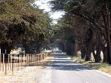
The Federation Trail is a shared use path for cyclists
and pedestrian
s, which mainly follows the old "Outfall Sewer" through the western suburbs of Melbourne
, Victoria
, Australia
.
For safety reasons cyclists are not allowed to use the Princes Highway
between Melbourne and the intersection of the highway and Geelong Road. West of this point cyclists are allowed on the highway. The Federation Trail is the preferred alternate route in the no go area.
It was officially opened on 22 October 2006.
In 2010 work started on extending the trail from Millers Road to Williamstown Rd. Completion of stage 1 of the VicRoads Truck Action Plan should see the trail finally connected from Williamstown Road to the Bay Trail - west side
.
Since March 2011, work on the extension has stopped completely. So far 1,300 metres of concrete path has been built, at a conservatively estimated cost of $520,000, which now lies idle. The new path is fenced off to potential users, who could easily access the path from the corner of Watson Street and Trumans Street as a temporary measure.
was the largest civil engineering
project ever undertaken in Victoria. The associated pumping station can be found in the Scienceworks Museum
complex.
Snakes may be seen in the Skeleton Creek and Werribee River areas during hot weather. Walkers are advised to stay on the path to enjoy the scenery.
(Laverton base), Lawrie Emmins Reserve, Skeleton Creek, Werribee Mercy Hospital
, Victoria University
(Werribee campus), Werribee Park
, Werribee Open Range Zoo
, Werribee River
.
in the west, at Werribee
and provides access to the Princes Highway
at this point. Near Hoppers Crossing it intersects with the upper section of the Skeleton Creek Trail
. It terminates at Millers Road in the east in Brooklyn
near Altona North
. 3.7 km west of Millers Road, it intersects the Western Ring Road Trail
.
The Hobsons Bay Coastal Trail
can be accessed from Millers Road but the road sections here are extremely busy and not recommended for the inexperienced. Forget Francis Street, go south under the West Gate Freeway
next to Millers Road then into Marigold Street, Kyle Street/Mills Street, Mason Street, cross the train track under Melbourne Road then North Road to the Hobsons Bay Coastal Trail
.
West end at 37.918980°S 144.658795°E.
East end at 37.823560°S 144.848403°E.
Cycling
Cycling, also called bicycling or biking, is the use of bicycles for transport, recreation, or for sport. Persons engaged in cycling are cyclists or bicyclists...
and pedestrian
Pedestrian
A pedestrian is a person traveling on foot, whether walking or running. In some communities, those traveling using roller skates or skateboards are also considered to be pedestrians. In modern times, the term mostly refers to someone walking on a road or footpath, but this was not the case...
s, which mainly follows the old "Outfall Sewer" through the western suburbs of Melbourne
Melbourne
Melbourne is the capital and most populous city in the state of Victoria, and the second most populous city in Australia. The Melbourne City Centre is the hub of the greater metropolitan area and the Census statistical division—of which "Melbourne" is the common name. As of June 2009, the greater...
, Victoria
Victoria (Australia)
Victoria is the second most populous state in Australia. Geographically the smallest mainland state, Victoria is bordered by New South Wales, South Australia, and Tasmania on Boundary Islet to the north, west and south respectively....
, Australia
Australia
Australia , officially the Commonwealth of Australia, is a country in the Southern Hemisphere comprising the mainland of the Australian continent, the island of Tasmania, and numerous smaller islands in the Indian and Pacific Oceans. It is the world's sixth-largest country by total area...
.
For safety reasons cyclists are not allowed to use the Princes Highway
West Gate Freeway
West Gate Freeway is a freeway in Melbourne, Australia, linking Geelong to Melbourne CBD and beyond. It is also a link between Melbourne and the west and linking industrial and residential areas west of the Yarra River with the city and port areas. The iconic West Gate Bridge is a part of the...
between Melbourne and the intersection of the highway and Geelong Road. West of this point cyclists are allowed on the highway. The Federation Trail is the preferred alternate route in the no go area.
It was officially opened on 22 October 2006.
In 2010 work started on extending the trail from Millers Road to Williamstown Rd. Completion of stage 1 of the VicRoads Truck Action Plan should see the trail finally connected from Williamstown Road to the Bay Trail - west side
Hobsons Bay Coastal Trail
The Hobsons Bay Coastal Trail is a shared use path for cyclists and pedestrians, which follows the coast line of Hobsons Bay in the inner western suburbs in Melbourne, Victoria, Australia. The trail forms part of the western half of the Bayside Trail which encircles Port Phillip...
.
Since March 2011, work on the extension has stopped completely. So far 1,300 metres of concrete path has been built, at a conservatively estimated cost of $520,000, which now lies idle. The new path is fenced off to potential users, who could easily access the path from the corner of Watson Street and Trumans Street as a temporary measure.
Following the path
Much of the trail follows the historic reservation of the "Main Outfall Sewer" which was built in the 1890s. At that time the sewerSanitary sewer
A sanitary sewer is a separate underground carriage system specifically for transporting sewage from houses and commercial buildings to treatment or disposal. Sanitary sewers serving industrial areas also carry industrial wastewater...
was the largest civil engineering
Civil engineering
Civil engineering is a professional engineering discipline that deals with the design, construction, and maintenance of the physical and naturally built environment, including works like roads, bridges, canals, dams, and buildings...
project ever undertaken in Victoria. The associated pumping station can be found in the Scienceworks Museum
Scienceworks Museum (Melbourne)
Scienceworks is a world renowned science museum in Melbourne, Australia. It is a venue of Museum Victoria which administers the cultural and scientific collections of the State of Victoria...
complex.
Snakes may be seen in the Skeleton Creek and Werribee River areas during hot weather. Walkers are advised to stay on the path to enjoy the scenery.
Landmarks
RAAF WilliamsRAAF Williams
RAAF Williams comprises the two bases of Point Cook and Laverton. Both establishments previously existed as separate RAAF Bases until 1999 when they were amalgamated to form RAAF Williams...
(Laverton base), Lawrie Emmins Reserve, Skeleton Creek, Werribee Mercy Hospital
Werribee Mercy Hospital
Werribee Mercy Hospital, located in the western Melbourne suburb of Werribee on the Princes Highway, is a large regional community public hospital that provides a broad range of services which include surgical, maternity, obstetric care, dialysis, emergency, mental health, aged and palliative...
, Victoria University
Victoria University, Australia
Victoria University is a multi-sector tertiary institution based in Melbourne, Australia with 10 campuses.VU offers qualifications in higher education, vocational education , and short courses...
(Werribee campus), Werribee Park
Werribee Park
Werribee Park is the estate of a historical building in Werribee, Victoria, Australia. It includes Werribee Park Mansion, the Victoria State Rose Garden, formal gardens, the Werribee Park National Equestrian Centre, the Werribee Open Range Zoo, a contemporary sculpture walk and a natural riverine...
, Werribee Open Range Zoo
Werribee Open Range Zoo
Werribee Open Range Zoo is an African themed zoo in Werribee, about south-west of Melbourne, Victoria, Australia. It is part of the Zoological Parks and Gardens Board or 'Zoos Victoria' which also includes Melbourne Zoo and Healesville Sanctuary. It is situated on approximately and is located on...
, Werribee River
Werribee River
The Werribee River is located on the plain west of Melbourne, Victoria, Australia. The headwaters of a tributary, the Lerderderg River, are north of Ballan near Daylesford and it flows across the basalt plain, through the suburb of Werribee to enter Port Phillip. A linear park follows the Werribee...
.
Connections
The trail meets the Werribee River TrailWerribee River Trail
The Werribee River Trail is a shared use path for cyclists and pedestrians, which follows Werribee River in the outer western suburb of Werribee in Melbourne, Victoria, Australia.North of the train line the path runs both sides of the river...
in the west, at Werribee
Werribee, Victoria
Werribee is a city in Melbourne, Australia, 32 km south-west from Melbourne's central business district. Its Local Government Area is the City of Wyndham. At the 2006 Census, Werribee had a population of 36,641. Statistically, Werribee is considered part of Greater Melbourne.Werribee is...
and provides access to the Princes Highway
Princes Highway
The Princes Highway extends from Sydney to Port Augusta via the coast through the states of New South Wales, Victoria and South Australia, a distance of 1941 km or 1898 km via the former alignments of the highway ....
at this point. Near Hoppers Crossing it intersects with the upper section of the Skeleton Creek Trail
Skeleton Creek Trail
The Skeleton Creek Trail is a shared use path for cyclists and pedestrians, which follows Skeleton Creek as it passes through the outer western suburb of Point Cook in Melbourne, Victoria, Australia....
. It terminates at Millers Road in the east in Brooklyn
Brooklyn, Victoria
Brooklyn is a suburb in Melbourne, Victoria, Australia, 10 km west from Melbourne's central business district. Its Local Government Area are the Cities of Hobsons Bay and Brimbank. At the 2006 Census, Brooklyn had a population of 1583.-Industry:...
near Altona North
Altona North, Victoria
Altona North is a suburb in Melbourne, Victoria, Australia, 10 km south-west from Melbourne's central business district. Its Local Government Area is the City of Hobsons Bay...
. 3.7 km west of Millers Road, it intersects the Western Ring Road Trail
Western Ring Road Trail
The Western Ring Road Trail is a shared use path for cyclists and pedestrians that bridges the northern suburbs and follows the Western Ring Road...
.
The Hobsons Bay Coastal Trail
Hobsons Bay Coastal Trail
The Hobsons Bay Coastal Trail is a shared use path for cyclists and pedestrians, which follows the coast line of Hobsons Bay in the inner western suburbs in Melbourne, Victoria, Australia. The trail forms part of the western half of the Bayside Trail which encircles Port Phillip...
can be accessed from Millers Road but the road sections here are extremely busy and not recommended for the inexperienced. Forget Francis Street, go south under the West Gate Freeway
West Gate Freeway
West Gate Freeway is a freeway in Melbourne, Australia, linking Geelong to Melbourne CBD and beyond. It is also a link between Melbourne and the west and linking industrial and residential areas west of the Yarra River with the city and port areas. The iconic West Gate Bridge is a part of the...
next to Millers Road then into Marigold Street, Kyle Street/Mills Street, Mason Street, cross the train track under Melbourne Road then North Road to the Hobsons Bay Coastal Trail
Hobsons Bay Coastal Trail
The Hobsons Bay Coastal Trail is a shared use path for cyclists and pedestrians, which follows the coast line of Hobsons Bay in the inner western suburbs in Melbourne, Victoria, Australia. The trail forms part of the western half of the Bayside Trail which encircles Port Phillip...
.
West end at 37.918980°S 144.658795°E.
East end at 37.823560°S 144.848403°E.