
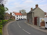
Airmyn
Encyclopedia

East Riding of Yorkshire
The East Riding of Yorkshire, or simply East Yorkshire, is a local government district with unitary authority status, and a ceremonial county of England. For ceremonial purposes the county also includes the city of Kingston upon Hull, which is a separate unitary authority...
, England
England
England is a country that is part of the United Kingdom. It shares land borders with Scotland to the north and Wales to the west; the Irish Sea is to the north west, the Celtic Sea to the south west, with the North Sea to the east and the English Channel to the south separating it from continental...
. It is situated at the mouth of the River Aire
River Aire
The River Aire is a major river in Yorkshire, England of length . Part of the river is canalised, and is known as the Aire and Calder Navigation....
with the River Ouse
River Ouse, Yorkshire
The River Ouse is a river in North Yorkshire, England. The river is formed from the River Ure at Cuddy Shaw Reach near Linton-on-Ouse, about 6 miles downstream of the confluence of the River Swale with the River Ure...
, approximately 2 miles (3.2 km) north west of Goole
Goole
Goole is a town, civil parish and port located approximately inland on the confluence of the rivers Don and Ouse in the East Riding of Yorkshire, England...
. It lies to the west of the M62 motorway
M62 motorway
The M62 motorway is a west–east trans-Pennine motorway in Northern England, connecting the cities of Liverpool and Hull via Manchester and Leeds. The road also forms part of the unsigned Euroroutes E20 and E22...
and the A614 road
A614 road
The A614 is a main road in England running through the counties of Nottinghamshire, South Yorkshire and the East Riding of Yorkshire.Beginning at Redhill, near Calverton in Nottinghamshire at a roundabout with the A60, the road meets the A6097 at a junction which looks like a roundabout but...
. According to the 2001 UK census
United Kingdom Census 2001
A nationwide census, known as Census 2001, was conducted in the United Kingdom on Sunday, 29 April 2001. This was the 20th UK Census and recorded a resident population of 58,789,194....
, Airmyn parish had a population of 795,
which had risen to over the 800 mark by 2006.
The parish was part of the Goole Rural District
Goole Rural District
Goole was a rural district in the West Riding of Yorkshire, England from 1894 to 1974.It was created under the Local Government Act 1894, based on most of the Goole rural sanitary district . The town of Goole itself formed a separate urban district...
in the West Riding of Yorkshire
West Riding of Yorkshire
The West Riding of Yorkshire is one of the three historic subdivisions of Yorkshire, England. From 1889 to 1974 the administrative county, County of York, West Riding , was based closely on the historic boundaries...
from 1894 to 1974, then in Boothferry district of Humberside
Humberside
Humberside was a non-metropolitan and ceremonial county in Northern England from 1 April 1974 until 1 April 1996. It was composed of land from either side of the Humber Estuary, created from portions of the East and West ridings of Yorkshire and parts of Lindsey, Lincolnshire...
until 1996. In the Middle Ages, Airmyn was a small port and up to the 18th century, its dead were taken by boat upstream to be buried at Snaith, as it was quicker to go by river than by horse and cart.
Buildings
Bradford
Bradford lies at the heart of the City of Bradford, a metropolitan borough of West Yorkshire, in Northern England. It is situated in the foothills of the Pennines, west of Leeds, and northwest of Wakefield. Bradford became a municipal borough in 1847, and received its charter as a city in 1897...
between 1866 and 1868, which was paid for by the village population, to honour the memory of the second Earl, who funded the building of the school.
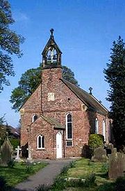
There is a fairly large memorial hall, located next to the village field and "Woodland Park" as named by an Airmyn Park Primary School pupil. A Post Office at the Memorial Hall is opened twice a week staffed by volunteers. The parish church of St David's is a Grade II listed building originally built in 1318 and extended in 1676. The roof was replaced with a new one of Westmorland slate
Slate
Slate is a fine-grained, foliated, homogeneous metamorphic rock derived from an original shale-type sedimentary rock composed of clay or volcanic ash through low-grade regional metamorphism. The result is a foliated rock in which the foliation may not correspond to the original sedimentary layering...
in 1858, as part of refurbishments that also included a bellcote and a porch on the west end. It has a well-kept graveyard.
Port of Airmyn
Although the River Aire joins the Ouse at Airmyn, the main port facilities for the Aire and Calder NavigationAire and Calder Navigation
The Aire and Calder Navigation is a river and canal system of the River Aire and the River Calder in the metropolitan county of West Yorkshire, England. The first improvements to the rivers above Knottingley were completed in 1704 when the Aire was made navigable to Leeds and the Calder to...
were originally further upstream at Rawcliffe
Rawcliffe, East Riding of Yorkshire
Rawcliffe is a village and civil parish in the East Riding of Yorkshire, England. It is situated approximately west of Goole...
. However, in 1736 they decided to buy land at Airmyn, as the water was deeper, and larger vessels could not always reach Rawcliffe, particularly on neap tides. The land was bought in 1744, and Airmyn gradually replaced Rawcliffe, as staiths, woolsheds, a crane and various other buildings were erected by those who leased the navigation. In 1750, the Aire and Calder Company repaid those who had built the facilities, and took ownership of them. By 1774, most of the Aire and Calder staff were also based at Airmyn. It became possible to catch a ship from Airmyn to London
London
London is the capital city of :England and the :United Kingdom, the largest metropolitan area in the United Kingdom, and the largest urban zone in the European Union by most measures. Located on the River Thames, London has been a major settlement for two millennia, its history going back to its...
, as a regular service began in 1758, charging the same fares as those from Hull
Kingston upon Hull
Kingston upon Hull , usually referred to as Hull, is a city and unitary authority area in the ceremonial county of the East Riding of Yorkshire, England. It stands on the River Hull at its junction with the Humber estuary, 25 miles inland from the North Sea. Hull has a resident population of...
to London.
Success was short-lived however. In 1774, the Aire and Calder decided to build the Selby Canal
Selby Canal
The Selby Canal is a canal with 2 locks which bypasses the lower reaches of the River Aire in Yorkshire, England, from the village of West Haddlesey to the town of Selby where it joins the River Ouse. It opened in 1778, and provided the main outlet for the Aire and Calder Navigation until 1826,...
, which would bypass the lower Aire and join the Ouse further upstream. Until them, Airmyn had acted as a transhipment point, where cargo was transferred from sea-going ships to river vessels. A new woolshed was built in 1775, and there was a coal yard, where coal was sold. Six staff were employed to manage the facility, which was also the base for the company's river boats. The place was obviously busy, as 19 boats were loaded in one week in July 1775, and nine vessels, one from London and eight from Hull, had arrived in a four-day period. Once the Selby Canal opened in 1776, decline was rapid. The coalyard and the offices closed in 1779, and two years later, all buildings on the north bank of the river were demolished, while those on the south bank were sold to Peter Birt. The boat repair yard closed soon afterwards.