
Ainapo Trail
Encyclopedia
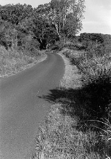
The Ainapo Trail was the primary route to the summit of Mauna Loa
from prehistory to 1916. The trail began on the southeast flank at 2000 feet of elevation and reached Mokuaweoweo, the summit crater, at 13200 feet (4,023.4 m). It was sometimes called Menzies Trail after Archibald Menzies
who was the first recorded outsider to climb the mountain in 1794.
to make offerings to Pele
during eruptions. The name comes from aina pō in the Hawaiian language
which means "darkened land", due to heavy clouds at the mid-elevation sections. At higher elevations above the clouds, the landscape is dry and barren lava rock. The climb is from about 2000 feet (609.6 m) at Kapapala to above 13200 feet (4,023.4 m) at the summit of Mokuaweoweo.
The trail was furnished with camps which provided rest areas and an opportunity to acclimate to the increasing altitude. The camps consisted of temporary huts, or rock shelters, one of which was in a lava tube
. In areas where the trail was hard to discern, rock cairns marked the way, placed to be visible along the skyline as travelers moved upwards.
In 1794, Archibald Menzies
, a naturalist on the Vancouver Expedition
, used the trail and about 100 Hawaiian porters to reach the summit and measure its elevation with a barometer
.
Lieutenant Charles Wilkes
of the 1840 United States Exploring Expedition
first attempted to use a shorter route, but resorted to the Ainapo trail after making much slower progress than he planned in his trip to the summit.
The trail was widened in 1870 and again in 1913 when horses and mules started bringing more visitors to the summit.
built a new trail directly from Kilauea Crater to Mokuaweoweo which was maintained by the National Park Service
when the Hawaii Volcanoes National Park
was formed in 1916. The historic route fell into disuse since the lower elevations covered private land used for ranching and farming.
Today, only the section of about 11 miles (17.7 km) above 11650 feet (3,550.9 m) remains in its original condition.
The 200 feet (61 m) on either side of the trail in this area was added to the National Register of Historic Places
on August 30, 1974 as site 74000290 and is state historic site 10-52-5501.
In the late 1990s a modern shelter was built at a historic camp site at an elevation of 7750 feet (2,362.2 m).
The lower area of Kapapala is now a private ranch, although hunting and camping can be arranged. Modern trails can now be taken from a trailhead on Ainapo road north of Hawaii Belt Road at coordinates 19°20′18"N 155°23′43"W, through the Kapapala State Forest Reserve, to the historic section of the Ainapo trail, all the way to the summit.
Mauna Loa
Mauna Loa is one of five volcanoes that form the Island of Hawaii in the U.S. state of Hawaii in the Pacific Ocean, and the largest on Earth in terms of volume and area covered. It is an active shield volcano, with a volume estimated at approximately , although its peak is about lower than that...
from prehistory to 1916. The trail began on the southeast flank at 2000 feet of elevation and reached Mokuaweoweo, the summit crater, at 13200 feet (4,023.4 m). It was sometimes called Menzies Trail after Archibald Menzies
Archibald Menzies
Archibald Menzies was a Scottish surgeon, botanist and naturalist.- Life and career :Menzies was born at Easter Stix in the parish of Weem, in Perthshire. While working with his elder brother William at the Royal Botanic Gardens, he drew the attention of Dr John Hope, professor of botany at...
who was the first recorded outsider to climb the mountain in 1794.
Early history
This 35 mile (55 km) route from the small community of Kapapala (near present-day Pahala) had been used in Ancient HawaiiAncient Hawaii
Ancient Hawaii refers to the period of Hawaiian human history preceding the unification of the Kingdom of Hawaii by Kamehameha the Great in 1810. After being first settled by Polynesian long-distance navigators sometime between AD 300–800, a unique culture developed. Diversified agroforestry and...
to make offerings to Pele
Pele (mythology)
In the Hawaiian religion, Pele is the goddess of fire, lightning, wind, and volcanoes. She is a popular figure in many stories of ancient Hawaii known as Hawaiian mythology.-Legends:...
during eruptions. The name comes from aina pō in the Hawaiian language
Hawaiian language
The Hawaiian language is a Polynesian language that takes its name from Hawaii, the largest island in the tropical North Pacific archipelago where it developed. Hawaiian, along with English, is an official language of the state of Hawaii...
which means "darkened land", due to heavy clouds at the mid-elevation sections. At higher elevations above the clouds, the landscape is dry and barren lava rock. The climb is from about 2000 feet (609.6 m) at Kapapala to above 13200 feet (4,023.4 m) at the summit of Mokuaweoweo.
The trail was furnished with camps which provided rest areas and an opportunity to acclimate to the increasing altitude. The camps consisted of temporary huts, or rock shelters, one of which was in a lava tube
Lava tube
Lava tubes are natural conduits through which lava travels beneath the surface of a lava flow, expelled by a volcano during an eruption. They can be actively draining lava from a source, or can be extinct, meaning the lava flow has ceased and the rock has cooled and left a long, cave-like...
. In areas where the trail was hard to discern, rock cairns marked the way, placed to be visible along the skyline as travelers moved upwards.
In 1794, Archibald Menzies
Archibald Menzies
Archibald Menzies was a Scottish surgeon, botanist and naturalist.- Life and career :Menzies was born at Easter Stix in the parish of Weem, in Perthshire. While working with his elder brother William at the Royal Botanic Gardens, he drew the attention of Dr John Hope, professor of botany at...
, a naturalist on the Vancouver Expedition
Vancouver Expedition
The Vancouver Expedition was a four-and-a-half-year voyage of exploration and diplomacy, commanded by Captain George Vancouver. The expedition circumnavigated the globe, touched five continents and changed the course of history for the indigenous nations and several European empires and their...
, used the trail and about 100 Hawaiian porters to reach the summit and measure its elevation with a barometer
Barometer
A barometer is a scientific instrument used in meteorology to measure atmospheric pressure. Pressure tendency can forecast short term changes in the weather...
.
Lieutenant Charles Wilkes
Charles Wilkes
Charles Wilkes was an American naval officer and explorer. He led the United States Exploring Expedition, 1838-1842 and commanded the ship in the Trent Affair during the American Civil War...
of the 1840 United States Exploring Expedition
United States Exploring Expedition
The United States Exploring Expedition was an exploring and surveying expedition of the Pacific Ocean and surrounding lands conducted by the United States from 1838 to 1842. The original appointed commanding officer was Commodore Thomas ap Catesby Jones. The voyage was authorized by Congress in...
first attempted to use a shorter route, but resorted to the Ainapo trail after making much slower progress than he planned in his trip to the summit.
The trail was widened in 1870 and again in 1913 when horses and mules started bringing more visitors to the summit.
Decline and revival
In 1915 the United States ArmyUnited States Army
The United States Army is the main branch of the United States Armed Forces responsible for land-based military operations. It is the largest and oldest established branch of the U.S. military, and is one of seven U.S. uniformed services...
built a new trail directly from Kilauea Crater to Mokuaweoweo which was maintained by the National Park Service
National Park Service
The National Park Service is the U.S. federal agency that manages all national parks, many national monuments, and other conservation and historical properties with various title designations...
when the Hawaii Volcanoes National Park
Hawaii Volcanoes National Park
Hawaii Volcanoes National Park, established in 1916, is a United States National Park located in the U.S. State of Hawaii on the island of Hawaii. It encompasses two active volcanoes: Kīlauea, one of the world's most active volcanoes, and Mauna Loa, the world's most massive volcano...
was formed in 1916. The historic route fell into disuse since the lower elevations covered private land used for ranching and farming.
Today, only the section of about 11 miles (17.7 km) above 11650 feet (3,550.9 m) remains in its original condition.
The 200 feet (61 m) on either side of the trail in this area was added to the National Register of Historic Places
National Register of Historic Places
The National Register of Historic Places is the United States government's official list of districts, sites, buildings, structures, and objects deemed worthy of preservation...
on August 30, 1974 as site 74000290 and is state historic site 10-52-5501.
In the late 1990s a modern shelter was built at a historic camp site at an elevation of 7750 feet (2,362.2 m).
The lower area of Kapapala is now a private ranch, although hunting and camping can be arranged. Modern trails can now be taken from a trailhead on Ainapo road north of Hawaii Belt Road at coordinates 19°20′18"N 155°23′43"W, through the Kapapala State Forest Reserve, to the historic section of the Ainapo trail, all the way to the summit.