
1972 Hurricane Agnes tornado outbreak
Encyclopedia
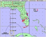
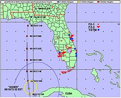
The 1972 Hurricane Agnes tornado outbreak, the third deadliest outbreak associated with a tropical cyclone in the United States since 1900, was the deadliest tornado outbreak
related to a tropical cyclone
in Florida
. The outbreak, produced by Hurricane Agnes
, lasted for 14.6 hours from June 18 to June 19. The outbreak resulted in 28 tornado
es, including 6 F0 events, 11 F1 events, 9 F2 events, and two F3 events on the Fujita scale
. Originally, only fifteen tornadoes were confirmed. Two of the tornadoes killed seven people and were not officially classified as tornadoes in the National Weather Service
records. The outbreak inflicted at least 140 injuries and destroyed fifteen homes, while 119 homes received damage. In all, 217 trailers were destroyed and 196 trailers incurred damage. Additionally, six businesses were destroyed, while six businesses were damaged.
 The interaction of baroclinic features with Agnes resulted in a tropical cyclone with "hybrid" characteristics, which increased the threat of strong tornadoes with longer path lengths. The outbreak became the most significant tornado outbreak associated with a tropical cyclone prior to landfall
. The presence of strong wind shear
surrounding the tropical cyclone facilitated the development of strong tornadoes, including the greatest number of tornadoes of at least F2 intensity within one 24-hour period in Florida. Studies have suggested strong wind shear in the lower levels of the atmosphere is a common feature during tornado outbreaks involving the outer rain bands
of tropical cyclones near Florida. Additionally, in Florida cases, the favored region for tornado outbreaks is the northeastern quadrant of north moving tropical cyclones. Agnes represented one of these cases.
 On June 18, a tornado touched down around 4:13 p.m. (EDT) near Fort Denaud, which is located near LaBelle
in Hendry County
. The tornado, killing one person, destroyed a truck and a trailer. The funnel also prostrated citrus trees and caused six injuries near LaBelle. Ten mobile homes were destroyed in two mobile home parks. In all, the tornado affected three mobile home parks and inflicted $200,000 (1972 USD
) in property damage. Another tornado, occurring around 10:55 p.m. (EDT), destroyed 50 mobile homes and one fish camp near Okeechobee
. This event killed six people and caused damage along a path that reached a width of 100 yards (0.05 mi). These tornadoes were operationally classified as "windstorms" in the official National Weather Service database, which indicated severe thunderstorm winds were responsible for the seven deaths. However, newspaper reports did cite the Okeechobee event as a tornado. Subsequently, an independent case study of the Hurricane Agnes outbreak in 1998 unveiled evidence that the events were two strong (F2–F3) tornadoes. However, the official database still lists the original number of tornadoes.
There were two unconfirmed tornadoes in Collier County
. A brief tornado reportedly damaged a roof and two planes in the town of Immokalee
. Power lines were downed in the area. Another possible tornado affected Everglades City
, where trees were prostrated and portions of a home were transported for 0.25 mile (0.4 km). Lee County was affected by three F2 tornadoes, while a F1 tornado touched down in Seminole County
. In all, the tornadoes in Lee, Seminole, and Brevard counties produced damages in excess of $100,000 (1972 USD).
states that his criteria yielded fewer strong tornadoes than the official records. The author cites only four strong tornadoes for the Hurricane Agnes tornado outbreak. Only one F3 tornado is listed, while three F2 tornadoes are included in the analysis. The official database lists six F2 events and two F3 events.
Tornado outbreak
While there is no single agreed upon definition, generally at least 6-10 tornadoes produced by the same synoptic scale weather system is considered a tornado outbreak. The tornadoes usually occur within the same day, or continue into the early morning hours of the succeeding day, and within the...
related to a tropical cyclone
Tropical cyclone
A tropical cyclone is a storm system characterized by a large low-pressure center and numerous thunderstorms that produce strong winds and heavy rain. Tropical cyclones strengthen when water evaporated from the ocean is released as the saturated air rises, resulting in condensation of water vapor...
in Florida
Florida
Florida is a state in the southeastern United States, located on the nation's Atlantic and Gulf coasts. It is bordered to the west by the Gulf of Mexico, to the north by Alabama and Georgia and to the east by the Atlantic Ocean. With a population of 18,801,310 as measured by the 2010 census, it...
. The outbreak, produced by Hurricane Agnes
Hurricane Agnes
Hurricane Agnes was the first tropical storm and first hurricane of the 1972 Atlantic hurricane season. A rare June hurricane, it made landfall on the Florida Panhandle before moving northeastward and ravaging the Mid-Atlantic region as a tropical storm...
, lasted for 14.6 hours from June 18 to June 19. The outbreak resulted in 28 tornado
Tornado
A tornado is a violent, dangerous, rotating column of air that is in contact with both the surface of the earth and a cumulonimbus cloud or, in rare cases, the base of a cumulus cloud. They are often referred to as a twister or a cyclone, although the word cyclone is used in meteorology in a wider...
es, including 6 F0 events, 11 F1 events, 9 F2 events, and two F3 events on the Fujita scale
Fujita scale
The Fujita scale , or Fujita-Pearson scale, is a scale for rating tornado intensity, based primarily on the damage tornadoes inflict on human-built structures and vegetation...
. Originally, only fifteen tornadoes were confirmed. Two of the tornadoes killed seven people and were not officially classified as tornadoes in the National Weather Service
National Weather Service
The National Weather Service , once known as the Weather Bureau, is one of the six scientific agencies that make up the National Oceanic and Atmospheric Administration of the United States government...
records. The outbreak inflicted at least 140 injuries and destroyed fifteen homes, while 119 homes received damage. In all, 217 trailers were destroyed and 196 trailers incurred damage. Additionally, six businesses were destroyed, while six businesses were damaged.
Summary
Landfall (meteorology)
Landfall is the event of a tropical cyclone or a waterspout coming onto land after being over water. When a waterspout makes landfall it is reclassified as a tornado, which can then cause damage inland...
. The presence of strong wind shear
Wind shear
Wind shear, sometimes referred to as windshear or wind gradient, is a difference in wind speed and direction over a relatively short distance in the atmosphere...
surrounding the tropical cyclone facilitated the development of strong tornadoes, including the greatest number of tornadoes of at least F2 intensity within one 24-hour period in Florida. Studies have suggested strong wind shear in the lower levels of the atmosphere is a common feature during tornado outbreaks involving the outer rain bands
Squall
A squall is a sudden, sharp increase in wind speed which is usually associated with active weather, such as rain showers, thunderstorms, or heavy snow. Squalls refer to an increase in the sustained winds over a short time interval, as there may be higher gusts during a squall event...
of tropical cyclones near Florida. Additionally, in Florida cases, the favored region for tornado outbreaks is the northeastern quadrant of north moving tropical cyclones. Agnes represented one of these cases.
LaBelle, Florida
LaBelle is a city in and the county seat of Hendry County, Florida, United States. The population was 4,210 at the 2000 census. As of 2004, the population recorded by the U.S. Census Bureau is 4,480 . It was named for Laura and Belle Hendry, daughters of pioneer cattleman Francis A...
in Hendry County
Hendry County, Florida
Hendry County is a county located in the U.S. state of Florida. As of 2000, the population was 36,210. The U.S. Census Bureau 2007 estimate for the county is 39,611 . Its county seat is La Belle. The county comprises the Clewiston, Florida, Micropolitan Statistical Area.-History:Hendry County...
. The tornado, killing one person, destroyed a truck and a trailer. The funnel also prostrated citrus trees and caused six injuries near LaBelle. Ten mobile homes were destroyed in two mobile home parks. In all, the tornado affected three mobile home parks and inflicted $200,000 (1972 USD
United States dollar
The United States dollar , also referred to as the American dollar, is the official currency of the United States of America. It is divided into 100 smaller units called cents or pennies....
) in property damage. Another tornado, occurring around 10:55 p.m. (EDT), destroyed 50 mobile homes and one fish camp near Okeechobee
Okeechobee, Florida
Okeechobee is a city in Okeechobee County, Florida, United States. The population was 5,376 at the 2000 census. As of 2004, the population recorded by the U.S. Census Bureau is 5,784. It is the county seat of Okeechobee County. The Speckled Perch Festival is held annually in honor of the most...
. This event killed six people and caused damage along a path that reached a width of 100 yards (0.05 mi). These tornadoes were operationally classified as "windstorms" in the official National Weather Service database, which indicated severe thunderstorm winds were responsible for the seven deaths. However, newspaper reports did cite the Okeechobee event as a tornado. Subsequently, an independent case study of the Hurricane Agnes outbreak in 1998 unveiled evidence that the events were two strong (F2–F3) tornadoes. However, the official database still lists the original number of tornadoes.
There were two unconfirmed tornadoes in Collier County
Collier County, Florida
Collier County is a county located in the U.S. state of Florida. As of 2000, the population was 251,377. The U.S. Census Bureau 2007 estimate for the county is 315,839...
. A brief tornado reportedly damaged a roof and two planes in the town of Immokalee
Immokalee, Florida
Immokalee is a census-designated place in Collier County, Florida, United States. The population was 19,763 at the 2000 census. It is part of the Naples–Marco Island Metropolitan Statistical Area. The settlement was originally known as Gopher Ridge...
. Power lines were downed in the area. Another possible tornado affected Everglades City
Everglades, Florida
Everglades is a city in Collier County, Florida, United States. The population was 479 at the 2000 census. As of 2004, the population recorded by the U.S. Census Bureau is 513...
, where trees were prostrated and portions of a home were transported for 0.25 mile (0.4 km). Lee County was affected by three F2 tornadoes, while a F1 tornado touched down in Seminole County
Seminole County, Florida
Seminole County is a county in the U.S. state of Florida. Located between Orlando to the south and Deland and Daytona Beach to the north, it is part of the Greater Orlando metropolitan area. Its county seat and largest city is Sanford...
. In all, the tornadoes in Lee, Seminole, and Brevard counties produced damages in excess of $100,000 (1972 USD).
Fujita scale ratings
Agnes produced a total of 8–11 strong (F2–F3) tornadoes in Florida. The accuracy of the ratings for many strong tornadoes in the 1950s, 1960s, and 1970s has been questioned by some authorities. Thomas P. GrazulisThomas P. Grazulis
Thomas P. Grazulis is a meteorologist who has written extensively about tornadoes and is head of the Tornado Project....
states that his criteria yielded fewer strong tornadoes than the official records. The author cites only four strong tornadoes for the Hurricane Agnes tornado outbreak. Only one F3 tornado is listed, while three F2 tornadoes are included in the analysis. The official database lists six F2 events and two F3 events.
Officially recorded tornadoes
June 18
| List of confirmed tornadoes | ||||||
|---|---|---|---|---|---|---|
Fujita scale The Fujita scale , or Fujita-Pearson scale, is a scale for rating tornado intensity, based primarily on the damage tornadoes inflict on human-built structures and vegetation... |
|
|
|
|
|
|
| Florida Florida Florida is a state in the southeastern United States, located on the nation's Atlantic and Gulf coasts. It is bordered to the west by the Gulf of Mexico, to the north by Alabama and Georgia and to the east by the Atlantic Ocean. With a population of 18,801,310 as measured by the 2010 census, it... |
||||||
| F2 | Big Coppitt Key Big Coppitt Key, Florida Big Coppitt Key is a census-designated place and an unincorporated community in Monroe County, Florida, on an island of the same name in the lower Florida Keys. The CDP also includes the neighboring islands of Geiger Key and Shark Key. As of the 2000 census, it had a total population of 2,595. ... |
Monroe Monroe County, Florida Monroe County is a county located in the state of Florida. As of 2000, the population was 79,589. The U.S. Census Bureau 2006 estimate for the county was 74,737.... |
0615 | 1 mile (1.6 km) |
In all, five homes and 47 trailers incurred damage. One frame residence lost its roof. 40 people were injured. Damages reached $342,000 (1972 USD). | |
| F2 | Key West Key West, Florida Key West is a city in Monroe County, Florida, United States. The city encompasses the island of Key West, the part of Stock Island north of U.S. 1 , Sigsbee Park , Fleming Key , and Sunset Key... |
Monroe Monroe County, Florida Monroe County is a county located in the state of Florida. As of 2000, the population was 79,589. The U.S. Census Bureau 2006 estimate for the county was 74,737.... |
0700 | 1 mile (1.6 km) |
Buildings were destroyed and lost roofs on the northern side of Key West. 50 people were injured. Losses reached $400,000 (1972 USD). | |
| F1 | Key Colony Beach Key Colony Beach, Florida Key Colony Beach is a city in the middle Florida Keys, Monroe County, Florida, United States. The population was 788 at the 2000 census. As of 2004, the population estimated by the U.S. Census Bureau is 852.-Geography:... to Long Key Long Key Long Key is an island in the middle Florida Keys.U.S. 1 crosses the key at approximately mile markers 65.5--71, between Fiesta Key and Conch Key.... |
Monroe Monroe County, Florida Monroe County is a county located in the state of Florida. As of 2000, the population was 79,589. The U.S. Census Bureau 2006 estimate for the county was 74,737.... |
1000 | 2 miles (3.2 km) |
The funnel passed through Key Colony Beach, Grassy Key, Conch Key, and Long Key. The majority of the damage occurred on Conch Key, where the tornado damaged six trailers. Damages were below $10,000 (1972 USD). | |
| F1 | Basinger area | Okeechobee Okeechobee County, Florida Okeechobee County is a county located in the state of Florida. As of 2000, the population was 35,910. According to 2005 U.S. Census estimates, its population had grown to 39,836. The county seat is Okeechobee, Florida. The county comprises the Okeechobee, Florida Micropolitan Statistical Area.-... |
1755 | 1 mile (1.6 km) |
The tornado touched the ground on U.S. Route 98 U.S. Route 98 U.S. Route 98 is an east–west United States highway that runs from western Mississippi to southern Florida. It was established in 1933 as a route between Pensacola, Florida and Apalachicola, Florida, and has since been extended westward into Mississippi and eastward across the Florida... . Two trailers were destroyed. One person received injuries, and four trailers were damaged. Damages reached $20,000 (1972 USD). |
|
| F2 | Sanibel Island Sanibel Island Sanibel Island is an island located on the Gulf coast of Florida, just offshore of Fort Myers. In 2000, it had an estimated population of 6,064 people... |
Lee Lee County, Florida Lee County is a county located in the U.S. state of Florida. Located in southwest Florida, the principal cities in the county are Fort Myers and Cape Coral... |
1838 | 0.3 mile (0.5 km) |
Five stores and the roof of a church were destroyed. Losses reached $15,000 (1972 USD). | |
| F2 | Pine Island Pine Island (Lee County, Florida) Pine Island is an island located in Lee County, Florida, on the Gulf coast of southwest Florida. It is the largest island in the state of Florida, and the 118th largest island in the United States. The Intracoastal Waterway passes through Pine Island Sound, to the west of the island. Matlacha Pass... |
Lee Lee County, Florida Lee County is a county located in the U.S. state of Florida. Located in southwest Florida, the principal cities in the county are Fort Myers and Cape Coral... |
1900 | 2 miles (3.2 km) |
The tornado passed through three trailer parks and destroyed four trailers. Several stores received damage. Losses were near $50,000 (1972 USD). | |
| F1 | Haines City Haines City, Florida Haines City is a city in Polk County, Florida, United States. The population was 13,174 at the 2000 census. As of 2010, the population estimated by the Bureau of Economic and Business Research at the University of Florida is 18,762. Haines City is the third most populous city in Polk County, Florida... area |
Polk Polk County, Florida Polk County is located in central Florida between the Tampa Bay and Greater Orlando metropolitan areas. The county was established by the state government in 1861 on the eve of the American Civil War and named after former United States president James K. Polk. The county seat is Bartow and its... |
1910 | 0.3 mile (0.5 km) |
Six mobile homes were severely damaged at the Haines City Mobile Home Park. Three minor injuries occurred. Damages reached $43,000 (1972 USD). | |
| F2 | Lehigh Acres Lehigh Acres, Florida Lehigh Acres is a census-designated place in Lee County, Florida, United States. The US Census Bureau estimates the CDP's population at 67,867 as of 2006... |
Lee Lee County, Florida Lee County is a county located in the U.S. state of Florida. Located in southwest Florida, the principal cities in the county are Fort Myers and Cape Coral... |
2000 | 0.5 mile (0.8 km) |
One TV transmitting tower was destroyed. Damages were estimated at $60,000 (1972 USD). The path of the tornado moved north. | |
| F1 | S of Zephyrhills Zephyrhills, Florida Zephyrhills is a city in Pasco County, Florida. The population was 10,833 at the 2000 census. According to the U.S. Census Bureau's 2004 estimates, the city had a population of 11,854. It is a suburb of the Tampa Bay Metropolitan Statistical Area... |
Pasco Pasco County, Florida Pasco County is a county located in the U.S. state of Florida. As of 2000, the population was 344,765. The July 1, 2007 census estimate according to the U.S. Census Bureau for the county is 462,715. Its county seat is Dade City, Florida which is in the northeast part of the county - somewhat... |
2140 | 0.2 mile (0.3 km) |
The tornado, striking Crystal Springs, damaged several mobile homes. Four people were injured. One of the injuries was classified as serious. Damages reached $20,000 (1972 USD). | |
| F1 | North Palm Beach North Palm Beach, Florida North Palm Beach is an incorporated village in Palm Beach County, Florida, United States. The population was 12,064 at the 2000 census. As of 2004, the population recorded by the U.S. Census Bureau is 12,645... area |
Palm Beach Palm Beach County, Florida Palm Beach County is the largest county in the state of Florida in total area, and third in population. As of 2010, the county's estimated population was 1,320,134, making it the twenty-eighth most populous in the United States... |
2240 | 0.3 mile (0.5 km) |
Tennis courts, a sailboat, and one home received damage. Losses reached $10,000 (1972 USD). The sailboat was lifted from a lake and deposited on a roof. | |
| F0 | W of Okeechobee Okeechobee, Florida Okeechobee is a city in Okeechobee County, Florida, United States. The population was 5,376 at the 2000 census. As of 2004, the population recorded by the U.S. Census Bureau is 5,784. It is the county seat of Okeechobee County. The Speckled Perch Festival is held annually in honor of the most... |
Highlands Highlands County, Florida Highlands County is a county located in the U.S. state of Florida. The U.S. Census Bureau 2006 estimate for the population was 97,346. Its county seat is Sebring, Florida. The county comprises the Sebring, Florida, Micropolitan Statistical Area.- History :... |
2245 | 1 mile (1.6 km) |
A brief tornado produced minimal damage near the intersection of the Kissimmee River Kissimmee River The Kissimmee River is a river in south-central Florida, United States.-Course:The Kissimmee River arises in Osceola County as the outflow from East Lake Tohopekaliga, passing through Lake Tohopekaliga, Lake Cypress, Lake Hatchineha and Lake Kissimmee... and Florida State Road 70. |
|
| F2 | Malabar Malabar, Florida Malabar is a town in Brevard County, Florida, United States. The population was 2,622 at the 2000 census. As of 2005, the population estimated by the U.S. Census Bureau is 2,772 . It is part of the Palm Bay–Melbourne–Titusville Metropolitan Statistical Area.-Geography:Malabar is... |
Brevard Brevard County, Florida Brevard County is a county located in the U.S. state of Florida, along the coast of the Atlantic Ocean. As of 2007 U.S. Census Bureau estimates, the population is 536,521, making it the 10th most populous county in the state. Influenced by the presence of the John F. Kennedy Space Center, Brevard... |
2346 | 2 miles (3.2 km) |
The Century Oaks Trailer Park was affected. In all, six trailers were destroyed, while nine trailers incurred damage. Homes were also damaged in Port Malabar. Eleven people were injured, and damage estimates reached $100,000 (1972 USD) at the trailer park. | |
| Sources: NCDC National Climatic Data Center The United States National Climatic Data Center in Asheville, North Carolina is the world's largest active archive of weather data. The center became established in late 1951, with the move into the new facility occurring in early 1952.... Storm Events Database, SPC Storm Prediction Center The Storm Prediction Center , located in Norman, Oklahoma, is tasked with forecasting the risk of severe thunderstorms and tornadoes in the contiguous United States. The agency issues convective outlooks, mesoscale discussions, and watches as a part of this process... Storm Data, NCDC Storm Data publication, Significant Tornadoes 1680-1991: A Chronology and Analysis of Events by Thomas P. Grazulis |
||||||
June 19
| List of confirmed tornadoes | ||||||
|---|---|---|---|---|---|---|
Fujita scale The Fujita scale , or Fujita-Pearson scale, is a scale for rating tornado intensity, based primarily on the damage tornadoes inflict on human-built structures and vegetation... |
|
|
|
|
|
|
| Florida Florida Florida is a state in the southeastern United States, located on the nation's Atlantic and Gulf coasts. It is bordered to the west by the Gulf of Mexico, to the north by Alabama and Georgia and to the east by the Atlantic Ocean. With a population of 18,801,310 as measured by the 2010 census, it... |
||||||
| F3 | Merritt Island Merritt Island, Florida Merritt Island is a census-designated place in Brevard County, Florida, United States. It is located on the east coast of the state on the Atlantic Ocean. As of the 2000 census, the population was 36,090. It is part of the Palm Bay – Melbourne – Titusville, Florida Metropolitan Statistical Area... |
Brevard Brevard County, Florida Brevard County is a county located in the U.S. state of Florida, along the coast of the Atlantic Ocean. As of 2007 U.S. Census Bureau estimates, the population is 536,521, making it the 10th most populous county in the state. Influenced by the presence of the John F. Kennedy Space Center, Brevard... |
0635 | 4 miles (6.4 km) |
One apartment building was destroyed. Two hangars, comprising 90 percent of the hangars, were destroyed at the Merritt Island Airport. 44 planes were also completely destroyed. One plane was carried more than 0.25 mile (0.40 km) from the airport and crashed into one home. The tornado produced damage to homes in a subdivision. Damages reached $3 million (1972 USD). One source, citing F2 damage, suggests that the tornado never attained F3 intensity. | |
| F3 | Cape Canaveral Cape Canaveral, Florida Cape Canaveral is a city in Brevard County, Florida, United States. The population was 8,829 at the 2000 census. As of 2008, the estimated population according to the U.S. Census Bureau was 10,147... |
Brevard Brevard County, Florida Brevard County is a county located in the U.S. state of Florida, along the coast of the Atlantic Ocean. As of 2007 U.S. Census Bureau estimates, the population is 536,521, making it the 10th most populous county in the state. Influenced by the presence of the John F. Kennedy Space Center, Brevard... |
0700 | 3 miles (4.8 km) |
The second F3 tornado struck the town of Cape Canaveral. Two homes and 30 trailers were destroyed. The Port Canaveral Port Canaveral Port Canaveral is a cruise, cargo and naval port in Brevard County, Florida, United States. It is one of the busiest cruise ports in the world with nearly 2.8 million multi-day cruise passengers passing through during 2010. As a deep water cargo port, it has a high volume of traffic. Over of bulk... Coast Guard station incurred $50,000 (1972 USD) in damages. 20 intact homes received damage from the tornado. 100 residents were homeless, and 23 people were injured. This tornado produced F3 damage. Losses exceeded $500,000 (1972 USD). |
|
| F1 | Geneva Geneva, Florida Geneva is a community, census-designated place, and an unincorporated area in Seminole County, Florida, United States. The population was 2,940 at the 2010 Census... area |
Seminole Seminole County, Florida Seminole County is a county in the U.S. state of Florida. Located between Orlando to the south and Deland and Daytona Beach to the north, it is part of the Greater Orlando metropolitan area. Its county seat and largest city is Sanford... |
0849 | 0.1 mile (0.2 km) |
Five homes were destroyed within a narrow swath of a trailer park. Losses reached $40,000 (1972 USD). | |
| Georgia Georgia (U.S. state) Georgia is a state located in the southeastern United States. It was established in 1732, the last of the original Thirteen Colonies. The state is named after King George II of Great Britain. Georgia was the fourth state to ratify the United States Constitution, on January 2, 1788... |
||||||
| F1 | SE of Homestead | Pierce Pierce County, Georgia Pierce County is a county located in the U.S. state of Georgia. As of 2000, the population was 15,636. The 2007 Census Estimate shows a population of 17,881. The county seat is Blackshear.... |
1825 | 1 mile (1.6 km) |
The first tornado in Georgia related to Agnes touched down around 12:25 pm CST near Homestead. The F1 tornado produced minor damage along its 1 mi (1.6 km) path; however, one person sustained injuries. Losses were estimated up to $25,000 (1972 USD). | |
| F2 | NE of Bethel | Coffee Coffee County, Georgia Coffee County is a county located in the U.S. state of Georgia. As of 2000, the population was 37,413. The 2007 Census Estimate shows a population of 40,085. The county seat is Douglas.-History:... |
2000 | 2 miles (3.2 km) |
The second and strongest tornado in Georgia related to Agnes touched down around 2:00 pm CST near Bethel. The F2 tornado produced moderate damage along its 2 mi (3.2 km) path, with losses estimated up to $250,000 (1972 USD). | |
| Sources: NCDC National Climatic Data Center The United States National Climatic Data Center in Asheville, North Carolina is the world's largest active archive of weather data. The center became established in late 1951, with the move into the new facility occurring in early 1952.... Storm Events Database, SPC Storm Prediction Center The Storm Prediction Center , located in Norman, Oklahoma, is tasked with forecasting the risk of severe thunderstorms and tornadoes in the contiguous United States. The agency issues convective outlooks, mesoscale discussions, and watches as a part of this process... Storm Data, NCDC Storm Data publication, Significant Tornadoes 1680-1991: A Chronology and Analysis of Events by Thomas P. Grazulis |
||||||
See also
- List of tornadoes and tornado outbreaks
- List of North American tornadoes and tornado outbreaks
- History of tropical cyclone-spawned tornadoesHistory of tropical cyclone-spawned tornadoesIntense tropical cyclones usually produce tornadoes, the majority of them weak, especially upon landfall.- List of Atlantic tropical cyclones which spawned tornadoes :These are the Atlantic tropical cyclones that are known to have spawned tornadoes in the U.S....