
1968 Illinois earthquake
Encyclopedia
The 1968 Illinois earthquake (or "New Madrid event") was the largest recorded earthquake in the U.S. Midwestern state of Illinois
. Striking at 11:02 a.m. on November 9, it measured 5.4 on the Richter scale. Although there were no fatalities, the event caused considerable structural damage to buildings, including the toppling of chimneys, and shaking in the region's largest city Chicago
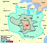
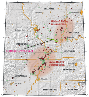
. The earthquake was one of the most widely felt in U.S. history, affecting 23 states over an area of 580000 square miles (1,502,193.1 km²). In studying its cause, scientists discovered the Cottage Grove Fault in the Southern Illinois Basin.
Within the region, millions felt the rupture. Reactions to the earthquake varied: some people near the epicenter did not react to the shaking, while others panicked. A future earthquake in the region is extremely likely; in 2005, seismologists and geologists estimated a 90% chance of a magnitude 6–7 tremor before 2055, likely originating in the Wabash Valley seismic zone
on the Illinois–Indiana border, or the New Madrid fault zone.
. Data from large earthquakes—in May and July 1909, and November 1968—suggest that earthquakes in the area are of moderate magnitude but can be felt over a large geographical area, largely because of the lack of fault lines. The May 1909 Aurora
earthquake affected people in an area of 500000 square miles (1,294,994.1 km²); the 1968 Illinois earthquake was felt by those living in an area of about 580000 square miles (1,502,193.1 km²). Contradicting the idea that the region's earthquakes are felt over a wide area, a 1965 shock was only noticed near Tamms
, even though it had the same intensity level (VII) as those of 1909 and 1968. Before 1968, earthquakes had been recorded in 1838, 1857, 1876, 1881, 1882, 1883, 1887, 1891, 1903, 1905, 1912, 1917, 1922, 1934, 1939, 1947, 1953, 1955, and 1958. Since 1968, other earthquakes have occurred in the same region in 1972, 1974, 1984, and 2008
.
 The quake struck on Saturday, November 9, 1968 at 11:02 a.m. The quake's epicenter
was slightly northwest of Broughton
in Hamilton County, and close to the Illinois–Indiana border, about 120 miles (193.1 km) east of St. Louis, Missouri
. Surrounding the epicenter were several small towns built on flat glacial lake plains
and low hills. Scientists described the rupture as "strong". During the quake, surface wave
and body wave
magnitudes were measured at 5.2 and 5.54 respectively. The magnitude of the quake reached 5.4 on the Richter scale. The earthquake occurred at a depth of 25 km (15.5 mi).
A fault plane solution
for the earthquake confirmed two nodal planes (one is always a fault plane, the other an auxiliary plane) striking north–south and dipping approximately 45 degrees to the east and to the west. This faulting suggests dip slip reverse motion and a horizontal east–west axis of confining stress. At the time of the earthquake, no faults were known in the immediate epicentral region (see below), but the motion corresponded to movement along the Wabash Valley Fault System roughly 10 miles (16.1 km) east of the region. The rupture also partly occurred on the New Madrid Fault, responsible for the great New Madrid earthquakes in 1812. The New Madrid tremors were the most powerful earthquakes to hit the contiguous United States
.
Various theories were put forward for the cause of the rupture. Donald Roll, director of seismology at Loyola University Chicago
, proposed that the quake was caused by massive amounts of silt
being deposited by rivers, generating a "seesaw" effect on the plates beneath. "The weight of the silt depressed one end of the block and tipped up the other," he said. However, scientists eventually realized the cause was a then-unknown fault, the Cottage Grove Fault, a small tear in the Earth's rock in the Southern Illinois Basin near the city of Harrisburg, Illinois
.
The fault, which is aligned east–west, is connected to the north–south trending Wabash Valley Fault System at its eastern end. Seismographic mapping completed by geologists revealed monocline
s, anticline
s, and syncline
s, all of which suggest deformation during the Paleozoic era, when strike-slip faulting took place nearby. The fault runs along an ancient Precambrian
terrane
boundary. It was active mainly in the Late Pennsylvanian and Early Permian epochs around 300 million years ago.
 The earthquake was felt in 23 states and affected a zone of 580000 square miles (1,502,193.1 km²). The shaking extended east to Pennsylvania and West Virginia, south to Mississippi and Alabama, north to Toronto
, Canada, and west to Oklahoma. Isolated reports were received from Boston
, Mobile, Alabama
, Pensacola, Florida
, southern Ontario
, Arkansas, Minnesota, Tennessee, Georgia, Kansas, Ohio, Mississippi, Kentucky, North Carolina, South Carolina, Missouri, West Virginia, Alabama, Nebraska, Iowa, Oklahoma, South Dakota, Pennsylvania, Michigan, and Wisconsin, presumably because of shaking. The worst affected areas were in the general area of Evansville, Indiana
, St. Louis, and Chicago
, but there was no major damage. There were no deaths; the worst injury was a child knocked unconscious by falling debris outside his home.
Damage was confined to Illinois, Indiana, Kentucky, Tennessee, and south-central Iowa, and largely consisted of fallen chimneys, foundation cracks, collapsed parapet
s, and overturned tombstones. In one home in Dale, Illinois
, near Tuckers Corners and southwest of McLeansboro
, the quake cracked interior walls, plaster, and chimneys. Using a type of victim study
, the local post office surveyed residents and implemented a field inspection which indicated the strongest shaking (MM VII
) took place in the Wabash Valley
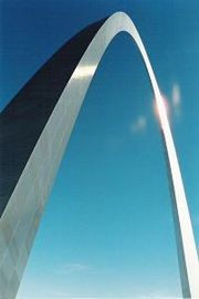
, Ohio Valley, and other nearby south-central Illinois lowlands. Outside this four-state zone, oscillating objects including cars, chimneys, and the Gateway Arch
were reported to authorities.
McLeansboro in particular experienced minor damage over an extensive area. Its local high school reported 19 broken windows in the girls' gymnasium, along with cracked plaster walls. Most of the high school's classrooms sustained fractured walls. The facade
of the town's First United Methodist Church was damaged, and a brick and concrete block fell off the top. Hamilton County Courthouse withstood several structural cracks, including one on the ceiling above the judge's seat. The town's residents also reported collapsing chimneys; three chimneys toppled at one home, leading to further damage.
Most of the buildings that experienced chimney damage were 30 to 50 years old. The City Building in Henderson, Kentucky
, 50 miles (80.5 km) east-southeast of the epicenter, sustained considerable structural damage. Moderate damage—including broken chimneys and fractured walls—occurred in towns in south-central Illinois, southwest Indiana, and northwest Kentucky. For instance, a concrete-brick cistern
caved in 6.2 miles (10 km) west of Dale.
In Lineville, Iowa, about 80 miles (128.7 km) south of Des Moines on the Missouri border, the quake was felt as a long shaking. The quake damaged the town's water tower which began to leak 300 gallons (1,135.6 l) of water an hour.
Donald Roll correctly predicted the earthquake would have no aftershocks. He later said, "That was kind of a safety valve. The pressure which has been built up has been released." He also described the earthquake as "a very rare occurrence".
inside had fallen.
People's reactions varied: some described themselves as "shocked"; others admitted to being "shaky" or nervous for the rest of the day. Harold Kittinger, a worker at the Suntone Factory, said, "I do not care to tell anyone I was frightened. But I was not shaking in my shoes. My shoes were moving." One woman hypothesized that the shaking was a "bomb". Grace Standerfer suggested the earthquake was sudden, saying, "I was just scared to death. My husband and I were in the house. The Venetian shades began to shake one way, then another. When that awful blast came, he grabbed me and we ran outside. Things were falling and breaking in the house. I said to him, 'This is it.' I thought the world had come to an end. Outside, wires were moving. There was no wind. The ground was quivering under our feet. I was so scared. I did not know I was scared." People in the community of Mount Vernon
were frightened by the shaking. However, some did not notice the earthquake; Jane Bessen said her party was "in a car ... to Evansville and didn't know about it until we got there".
and other experts concluded the land adjacent to the New Madrid fault was moving less than 0.2 millimetre (0.0078740157480315 in) a year, increasing the span between expected earthquakes on the fault to 500–1,000 years. Scientists anticipating a future earthquake suggest the Wabash Valley Fault
as a possible source, calling it "dangerous".
Douglas Wiens, a professor of earth and planetary sciences, reported: "The strongest earthquakes in the last few years have come from the Wabash Valley Fault", and said the fault needs more scientific observation. Steven Obermeir of the United States Geological Survey
is one of several scientists who have found sediments suggesting Wabash Valley Fault earthquakes around magnitude 7 on the Richter scale. Michael Wyssession, an associate professor of earth and planetary sciences, denigrated the Madrid fault zone and said, "in 20 years there have been three magnitude 5 or better earthquakes on the Wabash Valley Fault. There is evidence that sometime in the past the Wabash Valley Fault has produced as strong as magnitude 7 earthquakes. On the other hand, the New Madrid Fault has been very quiet for a long time now. Clearly, the Wabash Valley Fault has gotten our deserved attention."
Illinois
Illinois is the fifth-most populous state of the United States of America, and is often noted for being a microcosm of the entire country. With Chicago in the northeast, small industrial cities and great agricultural productivity in central and northern Illinois, and natural resources like coal,...
. Striking at 11:02 a.m. on November 9, it measured 5.4 on the Richter scale. Although there were no fatalities, the event caused considerable structural damage to buildings, including the toppling of chimneys, and shaking in the region's largest city Chicago
Chicago
Chicago is the largest city in the US state of Illinois. With nearly 2.7 million residents, it is the most populous city in the Midwestern United States and the third most populous in the US, after New York City and Los Angeles...
. The earthquake was one of the most widely felt in U.S. history, affecting 23 states over an area of 580000 square miles (1,502,193.1 km²). In studying its cause, scientists discovered the Cottage Grove Fault in the Southern Illinois Basin.
Within the region, millions felt the rupture. Reactions to the earthquake varied: some people near the epicenter did not react to the shaking, while others panicked. A future earthquake in the region is extremely likely; in 2005, seismologists and geologists estimated a 90% chance of a magnitude 6–7 tremor before 2055, likely originating in the Wabash Valley seismic zone
Wabash Valley Seismic Zone
The Wabash Valley Seismic Zone is a tectonic region located in the Midwest of the United States, centered on the valley of the Lower Wabash River, along the state line between southeastern Illinois and southwestern Indiana.-Geology:The Wabash Valley Seismic Zone consists largely of...
on the Illinois–Indiana border, or the New Madrid fault zone.
Background
The first recorded Illinois earthquake is from 1795, when a small earthquake shook the frontier settlement of KaskaskiaKaskaskia, Illinois
Kaskaskia is a village in Randolph County, Illinois, United States. In the 2010 census the population was 14, making it the second-smallest incorporated community in the State of Illinois in terms of population. A major French colonial town of the Illinois Country, its peak population was about...
. Data from large earthquakes—in May and July 1909, and November 1968—suggest that earthquakes in the area are of moderate magnitude but can be felt over a large geographical area, largely because of the lack of fault lines. The May 1909 Aurora
Aurora, Illinois
Aurora is the second most populous city in the U.S. state of Illinois, and the 112th largest city in the United States. A suburb of Chicago, located west of the Loop, its population in 2010 was 197,899. Originally founded within Kane County, Aurora's city limits have expanded greatly over the past...
earthquake affected people in an area of 500000 square miles (1,294,994.1 km²); the 1968 Illinois earthquake was felt by those living in an area of about 580000 square miles (1,502,193.1 km²). Contradicting the idea that the region's earthquakes are felt over a wide area, a 1965 shock was only noticed near Tamms
Tamms, Illinois
Tamms is a village in Alexander County, Illinois, United States. The population was 724 at the 2000 census. It is part of the Cape Girardeau–Jackson, MO-IL Metropolitan Statistical Area...
, even though it had the same intensity level (VII) as those of 1909 and 1968. Before 1968, earthquakes had been recorded in 1838, 1857, 1876, 1881, 1882, 1883, 1887, 1891, 1903, 1905, 1912, 1917, 1922, 1934, 1939, 1947, 1953, 1955, and 1958. Since 1968, other earthquakes have occurred in the same region in 1972, 1974, 1984, and 2008
2008 Illinois earthquake
The 2008 Illinois earthquake was one of the largest earthquakes ever recorded in the state of Illinois, measuring a magnitude of 5.4. It occurred at 4:37:00am CDT on April 18 within the Wabash Valley Seismic Zone at a depth of 11.6 km...
.
Geology
Epicenter
The epicenter or epicentre is the point on the Earth's surface that is directly above the hypocenter or focus, the point where an earthquake or underground explosion originates...
was slightly northwest of Broughton
Broughton, Illinois
Broughton is a village in Hamilton County, Illinois, United States. The population was 193 at the 2000 census. It is part of the Mount Vernon Micropolitan Statistical Area....
in Hamilton County, and close to the Illinois–Indiana border, about 120 miles (193.1 km) east of St. Louis, Missouri
Missouri
Missouri is a US state located in the Midwestern United States, bordered by Iowa, Illinois, Kentucky, Tennessee, Arkansas, Oklahoma, Kansas and Nebraska. With a 2010 population of 5,988,927, Missouri is the 18th most populous state in the nation and the fifth most populous in the Midwest. It...
. Surrounding the epicenter were several small towns built on flat glacial lake plains
Glacial lake
A glacial lake is a lake with origins in a melted glacier. Near the end of the last glacial period, roughly 10,000 years ago, glaciers began to retreat. A retreating glacier often left behind large deposits of ice in hollows between drumlins or hills. As the ice age ended, these melted to create...
and low hills. Scientists described the rupture as "strong". During the quake, surface wave
Surface wave magnitude
The surface wave magnitude scale is one of the magnitude scales used in seismology to describe the size of an earthquake. It is based on measurements in Rayleigh surface waves that travel primarily along the uppermost layers of the earth...
and body wave
Body wave magnitude
Body wave magnitude is a way of determining the size of an earthquake, using the amplitude of the initial P-wave to calculate the magnitude. The P-wave is a type of body wave that is capable of traveling through the earth at a velocity of around 5 to 8 km/s, and is the first wave from an...
magnitudes were measured at 5.2 and 5.54 respectively. The magnitude of the quake reached 5.4 on the Richter scale. The earthquake occurred at a depth of 25 km (15.5 mi).
A fault plane solution
Focal mechanism
The focal mechanism of an earthquake describes the inelastic deformation in the source region that generates the seismic waves. In the case of a fault-related event it refers to the orientation of the fault plane that slipped and the slip vector and is also known as a fault-plane solution...
for the earthquake confirmed two nodal planes (one is always a fault plane, the other an auxiliary plane) striking north–south and dipping approximately 45 degrees to the east and to the west. This faulting suggests dip slip reverse motion and a horizontal east–west axis of confining stress. At the time of the earthquake, no faults were known in the immediate epicentral region (see below), but the motion corresponded to movement along the Wabash Valley Fault System roughly 10 miles (16.1 km) east of the region. The rupture also partly occurred on the New Madrid Fault, responsible for the great New Madrid earthquakes in 1812. The New Madrid tremors were the most powerful earthquakes to hit the contiguous United States
Contiguous United States
The contiguous United States are the 48 U.S. states on the continent of North America that are south of Canada and north of Mexico, plus the District of Columbia....
.
Various theories were put forward for the cause of the rupture. Donald Roll, director of seismology at Loyola University Chicago
Loyola University Chicago
Loyola University Chicago is a private Jesuit research university located in Chicago, Illinois, United States. Founded by the Society of Jesus in 1870 under the title St...
, proposed that the quake was caused by massive amounts of silt
Silt
Silt is granular material of a size somewhere between sand and clay whose mineral origin is quartz and feldspar. Silt may occur as a soil or as suspended sediment in a surface water body...
being deposited by rivers, generating a "seesaw" effect on the plates beneath. "The weight of the silt depressed one end of the block and tipped up the other," he said. However, scientists eventually realized the cause was a then-unknown fault, the Cottage Grove Fault, a small tear in the Earth's rock in the Southern Illinois Basin near the city of Harrisburg, Illinois
Harrisburg, Illinois
Harrisburg is a city and township in Saline County, Illinois, United States. It is located about southwest of Evansville, Indiana, southeast of St. Louis, Missouri. The 2010 population was 9,017, with a township population of 10,790. It is the county seat of Saline County...
.
The fault, which is aligned east–west, is connected to the north–south trending Wabash Valley Fault System at its eastern end. Seismographic mapping completed by geologists revealed monocline
Monocline
A monocline is a step-like fold in rock strata consisting of a zone of steeper dip within an otherwise horizontal or gently-dipping sequence.-Formation:Monoclines may be formed in several different ways...
s, anticline
Anticline
In structural geology, an anticline is a fold that is convex up and has its oldest beds at its core. The term is not to be confused with antiform, which is a purely descriptive term for any fold that is convex up. Therefore if age relationships In structural geology, an anticline is a fold that is...
s, and syncline
Syncline
In structural geology, a syncline is a fold, with younger layers closer to the center of the structure. A synclinorium is a large syncline with superimposed smaller folds. Synclines are typically a downward fold, termed a synformal syncline In structural geology, a syncline is a fold, with younger...
s, all of which suggest deformation during the Paleozoic era, when strike-slip faulting took place nearby. The fault runs along an ancient Precambrian
Precambrian
The Precambrian is the name which describes the large span of time in Earth's history before the current Phanerozoic Eon, and is a Supereon divided into several eons of the geologic time scale...
terrane
Terrane
A terrane in geology is short-hand term for a tectonostratigraphic terrane, which is a fragment of crustal material formed on, or broken off from, one tectonic plate and accreted or "sutured" to crust lying on another plate...
boundary. It was active mainly in the Late Pennsylvanian and Early Permian epochs around 300 million years ago.
Damage
Toronto
Toronto is the provincial capital of Ontario and the largest city in Canada. It is located in Southern Ontario on the northwestern shore of Lake Ontario. A relatively modern city, Toronto's history dates back to the late-18th century, when its land was first purchased by the British monarchy from...
, Canada, and west to Oklahoma. Isolated reports were received from Boston
Boston
Boston is the capital of and largest city in Massachusetts, and is one of the oldest cities in the United States. The largest city in New England, Boston is regarded as the unofficial "Capital of New England" for its economic and cultural impact on the entire New England region. The city proper had...
, Mobile, Alabama
Mobile, Alabama
Mobile is the third most populous city in the Southern US state of Alabama and is the county seat of Mobile County. It is located on the Mobile River and the central Gulf Coast of the United States. The population within the city limits was 195,111 during the 2010 census. It is the largest...
, Pensacola, Florida
Pensacola, Florida
Pensacola is the westernmost city in the Florida Panhandle and the county seat of Escambia County, Florida, United States of America. As of the 2000 census, the city had a total population of 56,255 and as of 2009, the estimated population was 53,752...
, southern Ontario
Ontario
Ontario is a province of Canada, located in east-central Canada. It is Canada's most populous province and second largest in total area. It is home to the nation's most populous city, Toronto, and the nation's capital, Ottawa....
, Arkansas, Minnesota, Tennessee, Georgia, Kansas, Ohio, Mississippi, Kentucky, North Carolina, South Carolina, Missouri, West Virginia, Alabama, Nebraska, Iowa, Oklahoma, South Dakota, Pennsylvania, Michigan, and Wisconsin, presumably because of shaking. The worst affected areas were in the general area of Evansville, Indiana
Evansville, Indiana
Evansville is the third-largest city in the U.S. state of Indiana and the largest city in Southern Indiana. As of the 2010 census, the city had a total population of 117,429. It is the county seat of Vanderburgh County and the regional hub for both Southwestern Indiana and the...
, St. Louis, and Chicago
Chicago
Chicago is the largest city in the US state of Illinois. With nearly 2.7 million residents, it is the most populous city in the Midwestern United States and the third most populous in the US, after New York City and Los Angeles...
, but there was no major damage. There were no deaths; the worst injury was a child knocked unconscious by falling debris outside his home.
Damage was confined to Illinois, Indiana, Kentucky, Tennessee, and south-central Iowa, and largely consisted of fallen chimneys, foundation cracks, collapsed parapet
Parapet
A parapet is a wall-like barrier at the edge of a roof, terrace, balcony or other structure. Where extending above a roof, it may simply be the portion of an exterior wall that continues above the line of the roof surface, or may be a continuation of a vertical feature beneath the roof such as a...
s, and overturned tombstones. In one home in Dale, Illinois
Dale, Illinois
' is a populated place which is located in Hamilton County, Illinois, United States. The elevation of this place is 400 feet.The community is on the New Madrid Seismic Zone. The biggest earthquake in Illinois history was a 5.4 quake on November 9, 1968 near the community...
, near Tuckers Corners and southwest of McLeansboro
McLeansboro, Illinois
McLeansboro is a city in Hamilton County, Illinois, United States. The population was 2,883 at the 2010 census. It is the county seat of Hamilton County. Located in Southern Illinois, the town was named for Dr. William B. McLean, who donated the land for its founding...
, the quake cracked interior walls, plaster, and chimneys. Using a type of victim study
Victim study
A victim study is a survey, such as the British Crime Survey, that asks a sample of people which crimes have been committed against them over a fixed period of time and whether or not they have been reported to the police...
, the local post office surveyed residents and implemented a field inspection which indicated the strongest shaking (MM VII
Mercalli intensity scale
The Mercalli intensity scale is a seismic scale used for measuring the intensity of an earthquake. It measures the effects of an earthquake, and is distinct from the moment magnitude M_w usually reported for an earthquake , which is a measure of the energy released...
) took place in the Wabash Valley
Wabash Valley
The Wabash Valley is a region with parts in both Illinois and Indiana. It is named for the Wabash River and spans the middle to the middle-lower portion of the river and is centered at Terre Haute, Indiana...
, Ohio Valley, and other nearby south-central Illinois lowlands. Outside this four-state zone, oscillating objects including cars, chimneys, and the Gateway Arch
Gateway Arch
The Gateway Arch, or Gateway to the West, is an arch that is the centerpiece of the Jefferson National Expansion Memorial in St. Louis, Missouri. It was built as a monument to the westward expansion of the United States...
were reported to authorities.
McLeansboro in particular experienced minor damage over an extensive area. Its local high school reported 19 broken windows in the girls' gymnasium, along with cracked plaster walls. Most of the high school's classrooms sustained fractured walls. The facade
Facade
A facade or façade is generally one exterior side of a building, usually, but not always, the front. The word comes from the French language, literally meaning "frontage" or "face"....
of the town's First United Methodist Church was damaged, and a brick and concrete block fell off the top. Hamilton County Courthouse withstood several structural cracks, including one on the ceiling above the judge's seat. The town's residents also reported collapsing chimneys; three chimneys toppled at one home, leading to further damage.
Most of the buildings that experienced chimney damage were 30 to 50 years old. The City Building in Henderson, Kentucky
Henderson, Kentucky
Henderson is a city in Henderson County, Kentucky, United States, along the Ohio River in the western part of the state. The population was 27,952 at the 2010 census. It is part of the Evansville Metropolitan Area often referred to as "Kentuckiana", although "Tri-State Area" or "Tri-State" are more...
, 50 miles (80.5 km) east-southeast of the epicenter, sustained considerable structural damage. Moderate damage—including broken chimneys and fractured walls—occurred in towns in south-central Illinois, southwest Indiana, and northwest Kentucky. For instance, a concrete-brick cistern
Cistern
A cistern is a waterproof receptacle for holding liquids, usually water. Cisterns are often built to catch and store rainwater. Cisterns are distinguished from wells by their waterproof linings...
caved in 6.2 miles (10 km) west of Dale.
In Lineville, Iowa, about 80 miles (128.7 km) south of Des Moines on the Missouri border, the quake was felt as a long shaking. The quake damaged the town's water tower which began to leak 300 gallons (1,135.6 l) of water an hour.
Donald Roll correctly predicted the earthquake would have no aftershocks. He later said, "That was kind of a safety valve. The pressure which has been built up has been released." He also described the earthquake as "a very rare occurrence".
Response
Millions in the area experienced the earthquake, the first major seismic event in decades. Following the tremor, businesses in the area emptied. Many residents did not believe that the earthquake was over magnitude 5. Others did not realize an earthquake was taking place, for example, some residents thought their furnaces had exploded, and one man thought that the shaking was caused by his son "jumping up and down". At the Suntone Factory in McLeansboro, 30 miles (48 km) from the epicenter, workers rushed out of the building, thinking a 1100 gallons (4,164 l) water tankWater tank
A Water tank is a container for storing water. The need for a water tank is as old as civilized man, providing storage of water for drinking water, irrigation agriculture, fire suppression, agricultural farming, both for plants and livestock, chemical manufacturing, food preparation as well as many...
inside had fallen.
People's reactions varied: some described themselves as "shocked"; others admitted to being "shaky" or nervous for the rest of the day. Harold Kittinger, a worker at the Suntone Factory, said, "I do not care to tell anyone I was frightened. But I was not shaking in my shoes. My shoes were moving." One woman hypothesized that the shaking was a "bomb". Grace Standerfer suggested the earthquake was sudden, saying, "I was just scared to death. My husband and I were in the house. The Venetian shades began to shake one way, then another. When that awful blast came, he grabbed me and we ran outside. Things were falling and breaking in the house. I said to him, 'This is it.' I thought the world had come to an end. Outside, wires were moving. There was no wind. The ground was quivering under our feet. I was so scared. I did not know I was scared." People in the community of Mount Vernon
Mount Vernon, Illinois
Mount Vernon is a city located near the center of Jefferson County, Illinois, in the United States. In the 2010 census, the city's reported population was 15,277 people....
were frightened by the shaking. However, some did not notice the earthquake; Jane Bessen said her party was "in a car ... to Evansville and didn't know about it until we got there".
Future threats
In 2005, scientists determined there was a 90% probability of a magnitude 6–7 earthquake in the New Madrid area during the next 50 years. This could cause potentially high damage in the Chicago metropolitan area which has a population near ten million people. Pressure on the fault where the 1811–1812 Madrid earthquakes occurred was believed to be increasing, but a later study by Eric Calais of Purdue UniversityPurdue University
Purdue University, located in West Lafayette, Indiana, U.S., is the flagship university of the six-campus Purdue University system. Purdue was founded on May 6, 1869, as a land-grant university when the Indiana General Assembly, taking advantage of the Morrill Act, accepted a donation of land and...
and other experts concluded the land adjacent to the New Madrid fault was moving less than 0.2 millimetre (0.0078740157480315 in) a year, increasing the span between expected earthquakes on the fault to 500–1,000 years. Scientists anticipating a future earthquake suggest the Wabash Valley Fault
Wabash Valley Seismic Zone
The Wabash Valley Seismic Zone is a tectonic region located in the Midwest of the United States, centered on the valley of the Lower Wabash River, along the state line between southeastern Illinois and southwestern Indiana.-Geology:The Wabash Valley Seismic Zone consists largely of...
as a possible source, calling it "dangerous".
Douglas Wiens, a professor of earth and planetary sciences, reported: "The strongest earthquakes in the last few years have come from the Wabash Valley Fault", and said the fault needs more scientific observation. Steven Obermeir of the United States Geological Survey
United States Geological Survey
The United States Geological Survey is a scientific agency of the United States government. The scientists of the USGS study the landscape of the United States, its natural resources, and the natural hazards that threaten it. The organization has four major science disciplines, concerning biology,...
is one of several scientists who have found sediments suggesting Wabash Valley Fault earthquakes around magnitude 7 on the Richter scale. Michael Wyssession, an associate professor of earth and planetary sciences, denigrated the Madrid fault zone and said, "in 20 years there have been three magnitude 5 or better earthquakes on the Wabash Valley Fault. There is evidence that sometime in the past the Wabash Valley Fault has produced as strong as magnitude 7 earthquakes. On the other hand, the New Madrid Fault has been very quiet for a long time now. Clearly, the Wabash Valley Fault has gotten our deserved attention."