
1933 Sanriku earthquake
Encyclopedia
Earthquake
An earthquake is the result of a sudden release of energy in the Earth's crust that creates seismic waves. The seismicity, seismism or seismic activity of an area refers to the frequency, type and size of earthquakes experienced over a period of time...
whose associated tsunami
Tsunami
A tsunami is a series of water waves caused by the displacement of a large volume of a body of water, typically an ocean or a large lake...
caused widespread damage to towns on the Sanriku coast
Sanriku Coast
The is a coastal region on the Pacific Ocean, extending from southern Aomori prefecture, through Iwate prefecture and northern Miyagi prefecture in northeastern Honshū, which is Japan's main island...
of the Tōhoku region
Tohoku region
The is a geographical area of Japan. The region occupies the northeastern portion of Honshu, the largest island of Japan. The region consists of six prefectures : Akita, Aomori, Fukushima, Iwate, Miyagi and Yamagata....
of Honshū
Honshu
is the largest island of Japan. The nation's main island, it is south of Hokkaido across the Tsugaru Strait, north of Shikoku across the Inland Sea, and northeast of Kyushu across the Kanmon Strait...
, Japan
Japan
Japan is an island nation in East Asia. Located in the Pacific Ocean, it lies to the east of the Sea of Japan, China, North Korea, South Korea and Russia, stretching from the Sea of Okhotsk in the north to the East China Sea and Taiwan in the south...
on March 2, 1933.
History
The epicenter of the 1933 Sanriku earthquake was located offshore, 290 kilometres (180.2 mi)east of the city of Kamaishi, Iwate
Kamaishi, Iwate
is a small, historic city located on the Sanriku rias coast of Iwate, Japan. As of 2008, the city has an estimated population of 41,022 and a density of 92.9 persons per km². The total area is 441.42 km². It is famous in modern times for its steel production and most recently for its promotion...
. The initial shock occurred on at 0230 AM on March 2, 1933. The earthquake measured 8.4 on the moment magnitude scale
Moment magnitude scale
The moment magnitude scale is used by seismologists to measure the size of earthquakes in terms of the energy released. The magnitude is based on the seismic moment of the earthquake, which is equal to the rigidity of the Earth multiplied by the average amount of slip on the fault and the size of...
and was in approximately the same location as the 1896 Meiji-Sanriku earthquake
1896 Meiji-Sanriku earthquake
The 1896 Meiji-Sanriku earthquake was highly destructive, generating one of the most devastating tsunamis in Japanese history, destroying about 9,000 homes and causing at least 22,000 deaths. This magnitude 7.2 event occurred at 19:32 on June 15, 1896...
. The epicenter occurred far enough away from the town that the earthquake itself did little damage to buildings. Approximately three hours after the main shock was a magnitude 6.8 aftershock
Aftershock
An aftershock is a smaller earthquake that occurs after a previous large earthquake, in the same area of the main shock. If an aftershock is larger than the main shock, the aftershock is redesignated as the main shock and the original main shock is redesignated as a foreshock...
, followed by 76 more aftershocks (with a magnitude of 5.0 or greater) over a period of six months.
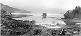
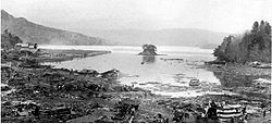
Damage
Although the earthquake did little damage, the associated tsunamiTsunami
A tsunami is a series of water waves caused by the displacement of a large volume of a body of water, typically an ocean or a large lake...
, which was recorded to reach the height of 28.7 metres (94.2 ft) at Ōfunato, Iwate
Ofunato, Iwate
is a coastal city located in Iwate, Japan.It was founded on April 1, 1952.On November 15, 2001, the town of Sanriku, from Kesen District, was merged into Ōfunato....
, caused extensive damage, destroyed many homes and caused numerous casualties The tsunami destroyed over 7,000 homes along the northern Japanese coastline, of which over 4,885 were washed away. The tsunami was also recorded in Hawaii
Hawaii
Hawaii is the newest of the 50 U.S. states , and is the only U.S. state made up entirely of islands. It is the northernmost island group in Polynesia, occupying most of an archipelago in the central Pacific Ocean, southwest of the continental United States, southeast of Japan, and northeast of...
with a height of 9.5 feet (2.9 m), and which also resulted in slight damage. The death toll came to 1522 people confirmed dead, 1542 missing, and 12,053 injured. Hardest hit was the town of Tarō, Iwate
Taro, Iwate
was a town located in Shimohei District, Iwate, Japan.On June 6, 2005 Tarō, along with the village of Niisato, was merged into the expanded city of Miyako and no longer exists as an independent municipality....
(now part of Miyako city
Miyako, Iwate
is a city located in Iwate, Japan.It was founded on February 11, 1941.The city lies along the coast where the flows into the Pacific Ocean. It is connected to Morioka by an east-west train line and highway and the coastal highway also goes through the town...
), with 98% of its houses destroyed and 42% of its population killed.
See also
- Seismicity of the Sanriku coast
- 869 Sanriku earthquake869 Sanriku earthquake and tsunamiThe struck the area around Sendai in the northern part of Honshu on 9 July 869 . The earthquake had an estimated magnitude of 8.6 on the surface wave magnitude scale...
- 1896 Meiji-Sanriku earthquake1896 Meiji-Sanriku earthquakeThe 1896 Meiji-Sanriku earthquake was highly destructive, generating one of the most devastating tsunamis in Japanese history, destroying about 9,000 homes and causing at least 22,000 deaths. This magnitude 7.2 event occurred at 19:32 on June 15, 1896...
- 2011 Tōhoku earthquake
- 869 Sanriku earthquake