

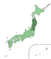
Tohoku region
Encyclopedia
Japan
Japan is an island nation in East Asia. Located in the Pacific Ocean, it lies to the east of the Sea of Japan, China, North Korea, South Korea and Russia, stretching from the Sea of Okhotsk in the north to the East China Sea and Taiwan in the south...
. The region occupies the northeastern portion of Honshu
Honshu
is the largest island of Japan. The nation's main island, it is south of Hokkaido across the Tsugaru Strait, north of Shikoku across the Inland Sea, and northeast of Kyushu across the Kanmon Strait...
, the largest island
Japanese Archipelago
The , which forms the country of Japan, extends roughly from northeast to southwest along the northeastern coast of the Eurasia mainland, washing upon the northwestern shores of the Pacific Ocean...
of Japan. The region consists of six prefectures
Prefectures of Japan
The prefectures of Japan are the country's 47 subnational jurisdictions: one "metropolis" , Tokyo; one "circuit" , Hokkaidō; two urban prefectures , Osaka and Kyoto; and 43 other prefectures . In Japanese, they are commonly referred to as...
(ken): Akita
Akita Prefecture
is a prefecture of Japan located in the Tōhoku Region of northern Honshu, the main island of Japan. The capital is the city of Akita.- History :The area of Akita has been created from the ancient provinces of Dewa and Mutsu....
, Aomori
Aomori Prefecture
is a prefecture of Japan located in the Tōhoku Region. The capital is the city of Aomori.- History :Until the Meiji Restoration, the area of Aomori prefecture was known as Mutsu Province....
, Fukushima
Fukushima Prefecture
is a prefecture of Japan located in the Tōhoku region on the island of Honshu. The capital is the city of Fukushima.-History:Until the Meiji Restoration, the area of Fukushima prefecture was known as Mutsu Province....
, Iwate
Iwate Prefecture
is the second largest prefecture of Japan after Hokkaido. It is located in the Tōhoku region of Honshū island and contains the island's easternmost point. The capital is Morioka. Iwate has the lowest population density of any prefecture outside Hokkaido...
, Miyagi
Miyagi Prefecture
is a prefecture of Japan in the Tōhoku Region on Honshu island. The capital is Sendai.- History :Miyagi Prefecture was formerly part of the province of Mutsu. Mutsu Province, on northern Honshu, was one of the last provinces to be formed as land was taken from the indigenous Emishi, and became the...
and Yamagata
Yamagata Prefecture
-Fruit:Yamagata Prefecture is the largest producer of cherries and pears in Japan. A large quantity of other kinds of fruits such as grapes, apples, peaches, melons, persimmons and watermelons are also produced.- Demographics :...
.
Tōhoku retains a reputation as a remote region, offering breathtaking scenery but a harsh climate
Climate
Climate encompasses the statistics of temperature, humidity, atmospheric pressure, wind, rainfall, atmospheric particle count and other meteorological elemental measurements in a given region over long periods...
. In the 20th century, tourism
Tourism
Tourism is travel for recreational, leisure or business purposes. The World Tourism Organization defines tourists as people "traveling to and staying in places outside their usual environment for not more than one consecutive year for leisure, business and other purposes".Tourism has become a...
became a major industry
Industry
Industry refers to the production of an economic good or service within an economy.-Industrial sectors:There are four key industrial economic sectors: the primary sector, largely raw material extraction industries such as mining and farming; the secondary sector, involving refining, construction,...
in the Tōhoku region.
History
The area was historically known as the MichinokuMichinoku region
is a geographical region of northern Honshu, Japan.-History:The use of Michinoku as a descriptive term is first recorded in .The usage and meaning of the term has evolved along with Japanese expansion northward in the 7th and 8th centuries...
region or province. a term first recorded in (654). There is some variation in modern usage of the term "Michinoku".
Tōhoku's initial historical settlement occurred between the seventh and ninth centuries, well after Japanese civilization
Heian period
The is the last division of classical Japanese history, running from 794 to 1185. The period is named after the capital city of Heian-kyō, or modern Kyōto. It is the period in Japanese history when Buddhism, Taoism and other Chinese influences were at their height...
and culture
Culture of Japan
The culture of Japan has evolved greatly over the millennia, from the country's prehistoric Jōmon period to its contemporary hybrid culture, which combines influences from Asia, Europe and North America...
had become firmly established in central and southwestern Japan. The last stronghold of the indigenous
Indigenous peoples
Indigenous peoples are ethnic groups that are defined as indigenous according to one of the various definitions of the term, there is no universally accepted definition but most of which carry connotations of being the "original inhabitants" of a territory....
Emishi
Emishi
The constituted a group of people who lived in northeastern Honshū in the Tōhoku region. They are referred to as in contemporary sources. Some Emishi tribes resisted the rule of the Japanese Emperors during the late Nara and early Heian periods...
on Honshu and the site of many battle
Battle
Generally, a battle is a conceptual component in the hierarchy of combat in warfare between two or more armed forces, or combatants. In a battle, each combatant will seek to defeat the others, with defeat determined by the conditions of a military campaign...
s.
Haiku
' , plural haiku, is a very short form of Japanese poetry typically characterised by three qualities:* The essence of haiku is "cutting"...
poet
Poet
A poet is a person who writes poetry. A poet's work can be literal, meaning that his work is derived from a specific event, or metaphorical, meaning that his work can take on many meanings and forms. Poets have existed since antiquity, in nearly all languages, and have produced works that vary...
Matsuo Bashō
Matsuo Basho
, born , then , was the most famous poet of the Edo period in Japan. During his lifetime, Bashō was recognized for his works in the collaborative haikai no renga form; today, after centuries of commentary, he is recognized as a master of brief and clear haiku...
wrote Oku no Hosomichi
Oku no Hosomichi
, translated alternately as The Narrow Road to the Deep North and The Narrow Road to the Interior, is a major work by the Japanese poet Matsuo Bashō considered "one of the major texts of classical Japanese literature."...
(The Narrow Road to the Deep North) during his travels through Tōhoku.
The catastrophic earthquake and tsunami
2011 Tōhoku earthquake and tsunami
The 2011 earthquake off the Pacific coast of Tohoku, also known as the 2011 Tohoku earthquake, or the Great East Japan Earthquake, was a magnitude 9.0 undersea megathrust earthquake off the coast of Japan that occurred at 14:46 JST on Friday, 11 March 2011, with the epicenter approximately east...
on March 11, 2011 inflicted significant damage along the east coast of this region.
Geography
Tōhoku, like most of Japan, is hilly or mountainous, with the Ōu MountainsOu Mountains
The are a mountain range in the Tōhoku region of Honshū, Japan. The range is the longest range in Japan and stretch south from the Natsudomari Peninsula of Aomori Prefecture to the Nasu volcanoes at the northern boundary of the Kantō region. Though long, the range is only about wide...
running north-south. The inland location of many of the region's lowland
Lowland
In physical geography, a lowland is any broad expanse of land with a general low level. The term is thus applied to the landward portion of the upward slope from oceanic depths to continental highlands, to a region of depression in the interior of a mountainous region, to a plain of denudation, or...
s has led to a concentration
Population density
Population density is a measurement of population per unit area or unit volume. It is frequently applied to living organisms, and particularly to humans...
of much of the population
Population
A population is all the organisms that both belong to the same group or species and live in the same geographical area. The area that is used to define a sexual population is such that inter-breeding is possible between any pair within the area and more probable than cross-breeding with individuals...
there. Coupled with coast
Coast
A coastline or seashore is the area where land meets the sea or ocean. A precise line that can be called a coastline cannot be determined due to the dynamic nature of tides. The term "coastal zone" can be used instead, which is a spatial zone where interaction of the sea and land processes occurs...
lines that do not favor seaport development
Urban planning
Urban planning incorporates areas such as economics, design, ecology, sociology, geography, law, political science, and statistics to guide and ensure the orderly development of settlements and communities....
, this settlement pattern resulted in a much greater than usual dependence on land
Road transport
Road transport or road transportation is transport on roads of passengers or goods. A hybrid of road transport and ship transport is the historic horse-drawn boat.-History:...
and railroad
Rail transport
Rail transport is a means of conveyance of passengers and goods by way of wheeled vehicles running on rail tracks. In contrast to road transport, where vehicles merely run on a prepared surface, rail vehicles are also directionally guided by the tracks they run on...
transport
Transport
Transport or transportation is the movement of people, cattle, animals and goods from one location to another. Modes of transport include air, rail, road, water, cable, pipeline, and space. The field can be divided into infrastructure, vehicles, and operations...
ation. Low points in the central mountain range fortunately make communication
Communication
Communication is the activity of conveying meaningful information. Communication requires a sender, a message, and an intended recipient, although the receiver need not be present or aware of the sender's intent to communicate at the time of communication; thus communication can occur across vast...
s between lowlands on either side of the range moderately easy.
Tōhoku was traditionally considered the granary
Granary
A granary is a storehouse for threshed grain or animal feed. In ancient or primitive granaries, pottery is the most common use of storage in these buildings. Granaries are often built above the ground to keep the stored food away from mice and other animals.-Early origins:From ancient times grain...
of Japan because it supplied Sendai and the Tokyo
Tokyo
, ; officially , is one of the 47 prefectures of Japan. Tokyo is the capital of Japan, the center of the Greater Tokyo Area, and the largest metropolitan area of Japan. It is the seat of the Japanese government and the Imperial Palace, and the home of the Japanese Imperial Family...
-Yokohama
Yokohama
is the capital city of Kanagawa Prefecture and the second largest city in Japan by population after Tokyo and most populous municipality of Japan. It lies on Tokyo Bay, south of Tokyo, in the Kantō region of the main island of Honshu...
market with rice
Rice
Rice is the seed of the monocot plants Oryza sativa or Oryza glaberrima . As a cereal grain, it is the most important staple food for a large part of the world's human population, especially in East Asia, Southeast Asia, South Asia, the Middle East, and the West Indies...
and other farm commodities
Commodity
In economics, a commodity is the generic term for any marketable item produced to satisfy wants or needs. Economic commodities comprise goods and services....
. Tōhoku provided 20 percent of the nation's rice crop. The climate, however, is harsher than in other parts of Honshū and permits only one crop a year on paddy field
Paddy field
A paddy field is a flooded parcel of arable land used for growing rice and other semiaquatic crops. Paddy fields are a typical feature of rice farming in east, south and southeast Asia. Paddies can be built into steep hillsides as terraces and adjacent to depressed or steeply sloped features such...
s.
In the 1960s, iron
Ironworks
An ironworks or iron works is a building or site where iron is smelted and where heavy iron and/or steel products are made. The term is both singular and plural, i.e...
, steel
Steelmaking
Steelmaking is the second step in producing steel from iron ore. In this stage, impurities such as sulfur, phosphorus, and excess carbon are removed from the raw iron, and alloying elements such as manganese, nickel, chromium and vanadium are added to produce the exact steel required.-Older...
, cement
Cement
In the most general sense of the word, a cement is a binder, a substance that sets and hardens independently, and can bind other materials together. The word "cement" traces to the Romans, who used the term opus caementicium to describe masonry resembling modern concrete that was made from crushed...
, chemical
Chemical industry
The chemical industry comprises the companies that produce industrial chemicals. Central to the modern world economy, it converts raw materials into more than 70,000 different products.-Products:...
, pulp
Pulp and paper industry
The global pulp and paper industry is dominated by North American , northern European and East Asian countries...
, and petroleum refining industries began developing.
Cities and populated areas
- AizuAizuis an area comprising the westernmost third of Fukushima Prefecture in Japan. The principal city of the area is Aizuwakamatsu.During the Edo period, Aizu was a feudal domain known as and part of Mutsu Province.-History:...
- AkitaAkita, Akitais the capital city of Akita Prefecture in the Tohoku region of Japan.As of June 11, 2005, with the merger of the former Kawabe District , the city has an estimated population of 323,310 and density of...
- AomoriAomori, Aomoriis the capital city of Aomori Prefecture, in the northern Tōhoku region of Japan. As of 2009, the city had an estimated population of 302,068 and a density of 366 persons per km². Its total area was 824.52 km².- History :...
- FukushimaFukushima, Fukushimais the capital city of Fukushima Prefecture in the Tōhoku Region of Japan. As of May 2011 the city has an estimated population of 290,064 and an area of 746.43 km².It lies about 250 km north of Tokyo and 80 km south of Sendai.-History:...
- HachinoheHachinohe, Aomori- Neighbouring municipalities :Aomori Prefecture*Sannohe District**Hashikami**Gonohe**Nanbu*Kamikita District**OiraseIwate Prefecture*Karumai-History:...
- HiraizumiHiraizumi, Iwateis a town located in Nishiiwai District, Iwate, Japan. It was the home of the Hiraizumi Fujiwaras for about 100 years in the late Heian era and most of the following Kamakura period. At the same time it served as the de facto capital of Oshu, an area containing nearly a third of the Japanese land...
- HirosakiHirosaki, Aomoriis a city located in southwest Aomori Prefecture, Japan. It is a castle town and was the Tsugaru clan ruled the 100,000 koku tozama han Hirosaki Domain from Hirosaki Castle during the Edo period. The city is currently a regional commercial center and the largest producer of apples in Japan...
- IwakiIwaki, Fukushimais a city located in the southern part of the Hamadōri coastal region of Fukushima Prefecture, Japan.A designated "core city", Iwaki is also one of the growing number of hiragana cities. Its area is 1,231.35 km², making it the 10th largest city in Japan...
- KakunodateKakunodate, AkitaKakunodate is a town located in Senboku, a city in Akita, Japan. Before Senboku became a city, Kakunodate was located in Senboku District.On September 20, 2005 the town merged with the town of Tazawako and the village of Nishiki to form the new city of Semboku.In 2003, the town had an estimated...
- Koriyama
- MisawaMisawa, Aomoriis a city located in eastern Aomori Prefecture in the Tōhoku region of Japan. As of 2009, the city had an estimated population of 42,399 and a density of 353 persons per km²...
- Misawa Air BaseMisawa Air Baseright|thumb|A US Navy C-2 at Misawa is a United States military facility located northeast of the railway station in Misawa, west of the Pacific Ocean, northeast of Towada, northwest of Hachinohe, and north of Tokyo, in Aomori Prefecture, in the Tōhoku region in the northern part of the...
- MoriokaMorioka, Iwateis the capital city of Iwate Prefecture, Japan.As of 2005, the city has an estimated population of 300,740 and a population density of 588.11 persons per km². The total area is 489.15 km²....
- SendaiSendai, Miyagiis the capital city of Miyagi Prefecture, Japan, and the largest city in the Tōhoku Region. In 2005, the city had a population of one million, and was one of Japan's 19 designated cities...
- Shingo villageShingo, Aomoriis a village located in the Sannohe District of south-central Aomori Prefecture in the Tōhoku region of Japan. As of 2009, the village had an estimated population of 2,830 and a density of 18.8 persons per km². Its total area was 150.85 km²...
- YamagataYamagata, Yamagatais the capital city of Yamagata Prefecture in Japan.As of July 1, 2011, the city has an estimated population of 253,951 with 97,457 households and a population density of 665.94 persons per km². The total area is 381.34 km². The city was founded on April 1, 1889.-Culture:The , one of Tōhoku's...
Natural features
- Mount BandaiMount Bandai, also known as , , and , is a stratovolcano in Fukushima Prefecture, Japan.In a major eruption on July 15, 1888 the north and east parts of the caldera collapsed in a massive landslide, forming two lakes, Hibara-ko and Onogawa-ko, as well as several minor lakes called Goshiki-numa, or the 'Five...
- Three Mountains of DewaThree Mountains of DewaThe refer to the three sacred mountains of Mount Haguro, Mount Gassan and Mount Yudono, which are clustered together in the ancient province of Dewa...
- Hakkōda Mountains
- Mount HayachineMount Hayachine, at , is the highest mountain in the Kitakami Range and the second highest in Iwate Prefecture after Mount Iwate.Mt. Hayachine is unusual in that it lies farther east than other large mountains on Honshu and the land in this area is the oldest in Japan...
- Mount IwakiMount Iwakiis a stratovolcano located in western Aomori Prefecture, Tohoku, Japan. It is also referred to as Tsugaru-Fuji from its shape. the mountain is listed as one of the 100 Famous Japanese Mountains in a book composed in 1964 by mountaineer/author Kyūya Fukada...
- Lake TazawaLake Tazawais a caldera lake in Semboku, Akita Prefecture, northern Japan. It is the deepest lake in Japan . Because of its depth, it never freezes....
- Lake TowadaLake Towadais the largest crater lake in Honshū island, Japan. Located on the border between Aomori and Akita prefectures, it lies 400 meters above sea level and is 327.0m depth, and is drained by the Oirase river. With a surface area of 61.1 km², Towada is Japan's 12th largest lake, its bright blue...
- Kitakami RiverKitakami RiverThe is the fourth largest river in Japan and the largest in the Tōhoku region. It is 249 kilometers long and drains an area of 10,150 square kilometers. It flows through mostly rural areas of Iwate and Miyagi Prefectures. The river is unusual in that it has two mouths, one flowing south into...
- Oirase RiverOirase RiverThe is a river located in eastern Aomori prefecture, Japan.The Oirase River is the only river draining Lake Towada, a large caldera lake on the border of Aomori and Akita Prefectures. The river flows in a generally eastern direction, through the municipalities of Towada, Rokunohe, Oirase and...
Valley - the islands of Matsushima BayMatsushimais a group of islands in Miyagi Prefecture, Japan. There are some 260 tiny islands covered in pines – hence the name – and is ranked as one of the Three Views of Japan....
- Mount OsoreMount Osoreis a region in the center of remote Shimokita Peninsula of Aomori Prefecture, Japan.According to popular mythology, Mount Osore marks the entrance to Hell, with a small brook running to the neighboring Lake Usorisan that is equated to the Sanzu River, a river that deceased souls needed to cross of...
- Sanriku Coastline
Parks
- Bandai-Asahi National ParkBandai-Asahi National Parkis a national park in the Tohoku region, Honshū, Japan. The park site straddles over Fukushima Prefecture, Yamagata Prefecture, and Niigata Prefecture. The park was designated as a national park on September 5, 1950...
- Miss Veedol BeachMiss VeedolThe Miss Veedol was the first airplane to fly non-stop across the Pacific Ocean. On October 5, 1931, Clyde Pangborn with co-pilot Hugh Herndon crash-landed the plane in the hills of East Wenatchee, Washington, in the central part of the state. and they became the first men to fly non-stop across...
- Rikuchu Kaigan National ParkRikuchu Kaigan National Parkis a national park in the Tohoku region of Honshū in northern Japan. The park extends for 180 kilometers from north to south along the coastline of the Pacific Ocean from northern Miyagi prefecture to northern Iwate prefecture...
- Towada-Hachimantai National ParkTowada-Hachimantai National ParkTowada-Hachimantai National Park is a national park in the Tohoku region, Honshū, Japan. The park covers Lake Towada, most of the Oirase River valley and the nearby Hachimantai plateau.-External links:...
See also
- 2011 Tōhoku earthquake and tsunami2011 Tōhoku earthquake and tsunamiThe 2011 earthquake off the Pacific coast of Tohoku, also known as the 2011 Tohoku earthquake, or the Great East Japan Earthquake, was a magnitude 9.0 undersea megathrust earthquake off the coast of Japan that occurred at 14:46 JST on Friday, 11 March 2011, with the epicenter approximately east...
- 2006 Kuril Islands earthquake2006 Kuril Islands earthquakeThe 2006 Kuril Islands earthquake was an 8.3 magnitude earthquake that hit the Kuril Islands at 11:14 UTC on November 15, 2006. A small tsunami hit the Japanese northern coast, with a larger wave following earlier small ones, due to reflection. The tsunami crossed the Pacific and did damage in...
- Geography of JapanGeography of JapanJapan is an island nation in East Asia comprising a stratovolcanic archipelago extending along the Pacific coast of Asia. Measured from the geographic coordinate system, Japan stretches from 24° to 46° north latitude and from 123° to 146° east longitude...
- Tōhoku dialect
- List of regions in Japan
External links
- Akita Prefecture Official website
- Aomori Prefecture Official website
- Fukushima Prefecture Official website
- Miyagi Prefecture Official website
- Yamagata Prefecture Official website
- Iwate Prefecture Living Guide for Foreign Nationals
- Tohoku Area Visit Blog