
Todos los Santos Lake
Encyclopedia
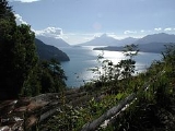
Lake Todos los Santos is a lake
located in the Los Lagos Region
of southern Chile
, 96 km northeast of the regional capital Puerto Montt
and 76 km east of Puerto Varas
, within the boundaries of the Vicente Pérez Rosales National Park
. It has a surface area of 178.5 km² and a maximum depth of 337 m. The Lake's National Park status has ensured protection to its environment. The catchment is largely covered with old-growth Valdivian temperate rain forests
. The present form of the lake is the result of glacial and volcanic processes.
The main tributary of the lake is the Río Peulla/Río Negro, next to the Peulla locality. Its outflow at the Petrohué locality gives rise to the Petrohué River
, with an average outflow of 270 m³ per second. Even though the lake has a regulating effect, it is subject to water level variations that may exceed 3 m and reflect in the discharge at the outflow. At a short distance from the Petrohué locality, the river flows through the Petrohué Waterfalls
.
A regular road/boat transport service provides tourist transport between Puerto Montt/Puerto Varas in Chile and San Carlos de Bariloche
on Nahuel Huapi Lake
in Argentina
. There are two main lake ports: Petrohué at the western end, and the village of Peulla at the eastern end; there is no road connecting these places. The lake is surrounded by steep mountains leaving only minor plains. Three snow-capped mountains are notorious: the Osorno volcano in the west, the Puntiagudo
to the north, and the Tronador
to the east.
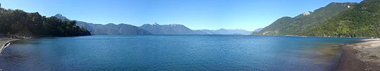 This lake has been known with various names in the past: Purailla, Pichilauquen, Quechocavi. In the tourist trade it is also known as Lago Esmeralda (Emerald Lake) due to the green color of its water. According to cloudiness and weather mood, the eye and the camera perceive the lake as green, blue or silvery.
Lake
A lake is a body of relatively still fresh or salt water of considerable size, localized in a basin, that is surrounded by land. Lakes are inland and not part of the ocean and therefore are distinct from lagoons, and are larger and deeper than ponds. Lakes can be contrasted with rivers or streams,...
located in the Los Lagos Region
Los Lagos Region
Los Lagos Region is one of Chile's 15 regions, which are first order administrative divisions, and comprises four provinces: Chiloé, Llanquihue, Osorno and Palena. The region contains the country's second largest island, Chiloé, and the second largest lake, Llanquihue.Its capital is Puerto Montt;...
of southern Chile
Chile
Chile ,officially the Republic of Chile , is a country in South America occupying a long, narrow coastal strip between the Andes mountains to the east and the Pacific Ocean to the west. It borders Peru to the north, Bolivia to the northeast, Argentina to the east, and the Drake Passage in the far...
, 96 km northeast of the regional capital Puerto Montt
Puerto Montt
Puerto Montt is a port city and commune in southern Chile, located at the northern end of the Reloncaví Sound in the Llanquihue Province, Los Lagos Region. The commune spans an area of and had a population of 175,938 in 2002. It is located 1,055 km to the south of the capital, Santiago...
and 76 km east of Puerto Varas
Puerto Varas
Puerto Varas is a city and commune located in the southern Chilean province of Llanquihue, in the Los Lagos Region.The city is well known for its German traditions, its food, its fish and seafood, the natural environment, its casino and 5 star hotels. Only from Puerto Montt, located on the shore...
, within the boundaries of the Vicente Pérez Rosales National Park
Vicente Pérez Rosales National Park
Vicente Pérez Rosales National Park is located in Los Lagos Region, Llanquihue Province, of Chile. Its western entrance is close to the Ensenada locality, northeast of the provincial capital of Puerto Montt, and from Puerto Varas along Ruta CH-225. This national park covers about and is almost...
. It has a surface area of 178.5 km² and a maximum depth of 337 m. The Lake's National Park status has ensured protection to its environment. The catchment is largely covered with old-growth Valdivian temperate rain forests
Valdivian temperate rain forests
The Valdivian temperate rain forests are a temperate broadleaf and mixed-forest ecoregion located on the west coast of southern South America, lying mostly in Chile and extending into a small part of Argentina. It is part of the Neotropic ecozone. The forests are named after the city of Valdivia...
. The present form of the lake is the result of glacial and volcanic processes.
The main tributary of the lake is the Río Peulla/Río Negro, next to the Peulla locality. Its outflow at the Petrohué locality gives rise to the Petrohué River
Petrohué River
Petrohué River is a Chilean river located in the Los Lagos Region of Chile. It originates from Todos los Santos Lake in the Vicente Pérez Rosales National Park...
, with an average outflow of 270 m³ per second. Even though the lake has a regulating effect, it is subject to water level variations that may exceed 3 m and reflect in the discharge at the outflow. At a short distance from the Petrohué locality, the river flows through the Petrohué Waterfalls
Petrohué Waterfalls
Petrohué Waterfalls is a chute-type waterfall in the upper reach of Petrohué River in Chile, a short distance downstream of the source of this river in Todos los Santos Lake. This waterfall is inside the Vicente Pérez Rosales National Park, close to the road leading to the Petrohue locality on...
.
A regular road/boat transport service provides tourist transport between Puerto Montt/Puerto Varas in Chile and San Carlos de Bariloche
San Carlos de Bariloche
San Carlos de Bariloche, usually known as Bariloche, is a city in the , situated in the foothills of the Andes on the southern shores of Nahuel Huapi Lake and is located inside Nahuel Huapi National Park...
on Nahuel Huapi Lake
Nahuel Huapi Lake
Nahuel Huapi Lake is a lake in the lake region of northern Patagonia between the provinces of Río Negro and Neuquén, in Argentina. The lake depression consists of several glacial valleys carved out along faults and Miocene valleys that were later dammed by moraines.Nahuel Huapi lake, located...
in Argentina
Argentina
Argentina , officially the Argentine Republic , is the second largest country in South America by land area, after Brazil. It is constituted as a federation of 23 provinces and an autonomous city, Buenos Aires...
. There are two main lake ports: Petrohué at the western end, and the village of Peulla at the eastern end; there is no road connecting these places. The lake is surrounded by steep mountains leaving only minor plains. Three snow-capped mountains are notorious: the Osorno volcano in the west, the Puntiagudo
Puntiagudo-Cordón Cenizos
Puntiagudo-Cordón Cenizos is a snow-capped volcanic chain located in the Andes, in Los Lagos Region of Chile, near Volcán Osorno. It lies between Rupanco Lake and Todos los Santos Lake...
to the north, and the Tronador
Tronador
Tronador is an extinct stratovolcano in the southern Andes, located along the border between Argentina and Chile near the city of Bariloche. The mountain was named Tronador by locals in reference to the sound of falling seracs...
to the east.