
Wroxham
Encyclopedia
Wroxham is a village and civil parish in the English
county
of Norfolk
. The civil parish of Wroxham has an area of 6.21 square kilometres and in 2001 had a population of 1532 in 666 households. The village is situated within the Norfolk Broads
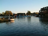
on the south side of a loop in the middle reaches of the River Bure
. It lies in an elevated position above the Bure, between Belaugh
Broad to the west and Wroxham Broad
to the east or south east. Wroxham is some eight miles north-east of Norwich
, to which it is linked by the A1151 road
. The village and broad lie in an area of fairly intensive agriculture, with areas of wet woodland adjoining the broad and river. For the purposes of local government, the parish falls within the district
of Broadland
although the river, broad and their immediate environs fall within the executive area of the Broads Authority
. On the northern side of the Bure is the village of Hoveton
, often confused with Wroxham.
) and a pilot station sits on the Hoveton side of the river to assist boaters for a fee: £6 per boat.
lies about one mile downstream from Wroxham Bridge. The broad has an area of 34.4 hectares and a mean depth of 1.3 metres. It lies to the west of the Bure, with two navigable openings between river and broad. The broad is popular for sailing and is the home of the Norfolk Broads Yacht Club. It is also an important habitat for broadland flora and fauna. Between 2000 and 2005 the island between the two channels linking Wroxham Broad to the Bure underwent restoration to stop erosion and improve the island's ecology, which had become degraded. The project was a joint initiative involving the Broads Authority
, Norfolk Broads Yacht Club and the local landowner, Trafford Estates. Scrub was cleared and a stretch of piling installed, allowing sedge, reed and rush to grow back. By 2005 it was reported that more birds, including kingfishers, were nesting on the island and the rare Cetti's warbler
was often spotted. Greater numbers of ducks including pochard and tufted ducks now wintered nearby and there was a greater profusion of wild flowers and marsh flora including orchids. During the course of the work, in 2004, volunteers came across an unexploded Second World War hand grenade in the dredgings, which had to be exploded by an army bomb disposal team.
for boating holidays and excursions from the late nineteenth century, when expansion of the rail network had made access to the area easier. The East Norfolk Railway arrived in Wroxham between 1874 and 1876 and John Loynes started the first boat hire firm on the Broads at Wroxham, where he moved the business he had started in Norwich in 1878.
However, Wroxham has almost merged with Hoveton
– each village growing on one bank of the river - with much of the area's commercial activity developing in Hoveton. The area around Wroxham Bridge is a local shopping centre, mainly due to the presence of Roys of Wroxham
– situated near Wroxham Bridge since 1899 and, since the 1930s, proud bearer of the accolade "world's largest village store". Roys owns much of the commercial property in the area. In fact, Roys of Wroxham is entirely situated on the Hoveton side of the river - as are the local post office and the Hotel Wroxham. It seems that the proximity and name of Wroxham Bridge - one side of which, naturally, is in Hoveton - gave rise to the common attribution of the name 'Wroxham' to that part of Hoveton that is close to the river and may be considered the commercial centre for both villages. Like many other local amenities, the station - previously called simply Wroxham Station - is actually located in Hoveton. Now called Hoveton and Wroxham railway station
, it is on the Bittern Line
from Norwich
to Cromer
and Sheringham
, and the terminus of the narrow gauge Bure Valley Railway
to Aylsham
.
and three shafts, described by the architectural historian Nikolaus Pevsner
as 'barbaric and glorious'. The church was heavily restored
in the Victorian age. In the churchyard is the Trafford Mausoleum, mediaeval in appearance but built in 1831. The area near the church was historically the core of the village. A brick and pantiled manor house to the south east of the church has a panel
dating to 1623 – its stepped gable
s show Dutch influence. A picturesque red brick grade II listed cottage dating from about 1820 abuts the churchyard.
Other significant houses in the village include Keys Hill House, built around 1890 by an important Norwich architect, Edward Boardman, to the east of Norwich Road, as a substantial country house in Jacobean style. It was later used as an old people's home. George Formby, the early twentieth-century entertainer, once owned a riverside home in Wroxham called Heronby, a thatched house built in 1907 in Beech Road, off the Avenue. Nearby is Charles Close, a mid-20th century residential development on the site of the Charles family's large Georgian mansion, Wroxham House, demolished in 1954. Closer to Wroxham Broad to the south stands the early 18th century red brick estate house Broad House, formerly the seat of the local land-owning Trafford family, more recently a 'boutique' hotel.
visited Wroxham in the 1930s. In his book Coot Club
(1934) he describes the busy scene on the river at Wroxham Bridge with numerous boats - a wherry
, punts, motor cruisers and sailing yachts - jostling for a mooring.
was opened in Hartwell Road, by the Wherry Yacht Charter Charitable Trust. Work began with the restoration of the Edwardian pleasure wherry the Norada, with restoration of two other wherries, the Olive and the Hathor, projected over the following two years. Once restored, the wherries are intended to be available for use by school and youth groups as well as by private charter. A third of the cost of the project came from the Heritage Lottery Fund
.
in 1947. The original railway runs on a 3.5" gauge track with a miniature steam locomotive. In 1979, work started on the 7.25" gauge 'Riverside' railway which ran initially with an electric engine and later with a steam locomotive. Barton House Railway is run by volunteers and makes donations from proceeds to local charities.
England
England is a country that is part of the United Kingdom. It shares land borders with Scotland to the north and Wales to the west; the Irish Sea is to the north west, the Celtic Sea to the south west, with the North Sea to the east and the English Channel to the south separating it from continental...
county
County
A county is a jurisdiction of local government in certain modern nations. Historically in mainland Europe, the original French term, comté, and its equivalents in other languages denoted a jurisdiction under the sovereignty of a count A county is a jurisdiction of local government in certain...
of Norfolk
Norfolk
Norfolk is a low-lying county in the East of England. It has borders with Lincolnshire to the west, Cambridgeshire to the west and southwest and Suffolk to the south. Its northern and eastern boundaries are the North Sea coast and to the north-west the county is bordered by The Wash. The county...
. The civil parish of Wroxham has an area of 6.21 square kilometres and in 2001 had a population of 1532 in 666 households. The village is situated within the Norfolk Broads
The Broads
The Broads are a network of mostly navigable rivers and lakes in the English counties of Norfolk and Suffolk. The Broads, and some surrounding land were constituted as a special area with a level of protection similar to a UK National Park by The Norfolk and Suffolk Broads Act of 1988...
on the south side of a loop in the middle reaches of the River Bure
River Bure
The River Bure is a river in the county of Norfolk, England, most of it in The Broads. The Bure rises near Melton Constable, upstream of Aylsham, which was the original head of navigation. Nowadays, the head of navigation is downstream at Coltishall Bridge...
. It lies in an elevated position above the Bure, between Belaugh
Belaugh
Belaugh is a small village that occupies a bend in the River Bure in Norfolk, England - within The Broads National Park. It is accessible via the road between Hoveton and Coltishall or from the river. It contains no pubs, bars or shops...
Broad to the west and Wroxham Broad
Wroxham Broad
Wroxham Broad is on the River Bure near the village of Wroxham in Norfolk, England within The Broads National Park. The broad has an area of 34.4 hectares and a mean depth of 1.3 metres. It lies to the west of the Bure, with two navigable openings between river and broad...
to the east or south east. Wroxham is some eight miles north-east of Norwich
Norwich
Norwich is a city in England. It is the regional administrative centre and county town of Norfolk. During the 11th century, Norwich was the largest city in England after London, and one of the most important places in the kingdom...
, to which it is linked by the A1151 road
A1151 road
The A1151 is an A road, running entirely in the English county of Norfolk, in the East Anglia region of England. The road runs from the city of Norwich, and terminates at a junction with the A149, near Smallburgh.-Route:...
. The village and broad lie in an area of fairly intensive agriculture, with areas of wet woodland adjoining the broad and river. For the purposes of local government, the parish falls within the district
Non-metropolitan district
Non-metropolitan districts, or colloquially shire districts, are a type of local government district in England. As created, they are sub-divisions of non-metropolitan counties in a so-called "two-tier" arrangement...
of Broadland
Broadland
Broadland is a local government district in Norfolk, England, named after the Norfolk Broads. Its council is based in Thorpe St Andrew, which is a suburb of the City of Norwich.-History:The district was formed on April 1, 1974 by the merger of St...
although the river, broad and their immediate environs fall within the executive area of the Broads Authority
Broads Authority
The Broads Authority is the agency which has statutory responsibility for the Broads in England. Originally, the Nature Conservancy Council , pressed for a special authority to manage the Broads which had been neglected for a long time. In 1978, the forerunner to the present-day Broads Authority...
. On the northern side of the Bure is the village of Hoveton
Hoveton
Hoveton is a village and civil parish in the English county of Norfolk. It is located within the Norfolk Broads, and immediately across the River Bure from the village of Wroxham...
, often confused with Wroxham.
Wroxham Bridge
Wroxham Bridge was rebuilt of brick and stone in 1619, replacing a bridge built in 1576 which itself replaced an earlier, probably wooden, structure. It is considered to be the second most difficult on the Broads to navigate (after Potter HeighamPotter Heigham
Potter Heigham is a village and civil parish on the River Thurne in the English county of Norfolk. It is situated some north-east of the city of Norwich on the A149 road, and on The Broads....
) and a pilot station sits on the Hoveton side of the river to assist boaters for a fee: £6 per boat.
The Broad
Wroxham BroadWroxham Broad
Wroxham Broad is on the River Bure near the village of Wroxham in Norfolk, England within The Broads National Park. The broad has an area of 34.4 hectares and a mean depth of 1.3 metres. It lies to the west of the Bure, with two navigable openings between river and broad...
lies about one mile downstream from Wroxham Bridge. The broad has an area of 34.4 hectares and a mean depth of 1.3 metres. It lies to the west of the Bure, with two navigable openings between river and broad. The broad is popular for sailing and is the home of the Norfolk Broads Yacht Club. It is also an important habitat for broadland flora and fauna. Between 2000 and 2005 the island between the two channels linking Wroxham Broad to the Bure underwent restoration to stop erosion and improve the island's ecology, which had become degraded. The project was a joint initiative involving the Broads Authority
Broads Authority
The Broads Authority is the agency which has statutory responsibility for the Broads in England. Originally, the Nature Conservancy Council , pressed for a special authority to manage the Broads which had been neglected for a long time. In 1978, the forerunner to the present-day Broads Authority...
, Norfolk Broads Yacht Club and the local landowner, Trafford Estates. Scrub was cleared and a stretch of piling installed, allowing sedge, reed and rush to grow back. By 2005 it was reported that more birds, including kingfishers, were nesting on the island and the rare Cetti's warbler
Cetti's Warbler
Cetti's Warbler , Cettia cetti, is an Old World warbler which breeds in Europe, northwest Africa and east southern temperate Asia as far as Afghanistan and NW Pakistan. It is the only bush warbler to occur outside Asia...
was often spotted. Greater numbers of ducks including pochard and tufted ducks now wintered nearby and there was a greater profusion of wild flowers and marsh flora including orchids. During the course of the work, in 2004, volunteers came across an unexploded Second World War hand grenade in the dredgings, which had to be exploded by an army bomb disposal team.
'Capital of the Broads'
Wroxham is sometimes called the "Capital of the Broads" and was the first centre on the BroadsThe Broads
The Broads are a network of mostly navigable rivers and lakes in the English counties of Norfolk and Suffolk. The Broads, and some surrounding land were constituted as a special area with a level of protection similar to a UK National Park by The Norfolk and Suffolk Broads Act of 1988...
for boating holidays and excursions from the late nineteenth century, when expansion of the rail network had made access to the area easier. The East Norfolk Railway arrived in Wroxham between 1874 and 1876 and John Loynes started the first boat hire firm on the Broads at Wroxham, where he moved the business he had started in Norwich in 1878.
Wroxham and Hoveton
Both Wroxham and Hoveton have several boat building and pleasure craft hire yards. Other local industries include the canning of soft fruits. Wroxham village had at one time - for much of the 20th century - its own public house (The Castle, in Norwich Road), sub-post office and primary school (in Church Lane), all now closed. A few small shops remain along Norwich Road and a public library was built near Bridge Broad, a small broad near Wroxham Bridge, in the 1960s.However, Wroxham has almost merged with Hoveton
Hoveton
Hoveton is a village and civil parish in the English county of Norfolk. It is located within the Norfolk Broads, and immediately across the River Bure from the village of Wroxham...
– each village growing on one bank of the river - with much of the area's commercial activity developing in Hoveton. The area around Wroxham Bridge is a local shopping centre, mainly due to the presence of Roys of Wroxham
Roys of Wroxham
Roys of Wroxham is a family owned group of general stores based in Hoveton, Norfolk in an area generally known as Wroxham. The store after winning a competition in the early 1930s uses the motto "The World's Largest Village Store" in all its advertising and literature-History:Roys was founded in...
– situated near Wroxham Bridge since 1899 and, since the 1930s, proud bearer of the accolade "world's largest village store". Roys owns much of the commercial property in the area. In fact, Roys of Wroxham is entirely situated on the Hoveton side of the river - as are the local post office and the Hotel Wroxham. It seems that the proximity and name of Wroxham Bridge - one side of which, naturally, is in Hoveton - gave rise to the common attribution of the name 'Wroxham' to that part of Hoveton that is close to the river and may be considered the commercial centre for both villages. Like many other local amenities, the station - previously called simply Wroxham Station - is actually located in Hoveton. Now called Hoveton and Wroxham railway station
Hoveton and Wroxham railway station
Hoveton and Wroxham is a railway station serving the town of Wroxham in the English county of Norfolk. The station is technically situated in the adjacent village of Hoveton, but the two settlements are usually regarded as one....
, it is on the Bittern Line
Bittern Line
The Bittern Line is a railway line from Norwich to Cromer then Sheringham in Norfolk, England. It is one of the most scenic in the East of England traversing the Norfolk Broads on its route to the Area of Outstanding Natural Beauty on the North Norfolk Coast. The line is part of the Network Rail...
from Norwich
Norwich
Norwich is a city in England. It is the regional administrative centre and county town of Norfolk. During the 11th century, Norwich was the largest city in England after London, and one of the most important places in the kingdom...
to Cromer
Cromer
Cromer is a coastal town and civil parish in north Norfolk, England. The local government authority is North Norfolk District Council, whose headquarters is in Holt Road in the town. The town is situated 23 miles north of the county town, Norwich, and is 4 miles east of Sheringham...
and Sheringham
Sheringham
Sheringham is a seaside town in Norfolk, England, west of Cromer.The motto of the town, granted in 1953 to the Sheringham Urban District Council, is Mare Ditat Pinusque Decorat, Latin for "The sea enriches and the pine adorns"....
, and the terminus of the narrow gauge Bure Valley Railway
Bure Valley Railway
The Bure Valley Railway is a minimum gauge heritage railway in Norfolk, within The Broads National Park.The railway runs from Wroxham to Aylsham and is Norfolk's longest railway of less than standard gauge. It uses both steam and diesel locomotives. There are intermediate halts at Brampton,...
to Aylsham
Aylsham
Aylsham is a historic market town and civil parish on the River Bure in north Norfolk, England, about north of Norwich. The river rises near Melton Constable, upstream from Aylsham and continues to Great Yarmouth and the North Sea, although it was only made navigable after 1779, allowing grain,...
.
Significant buildings
The Church of St Mary the Virgin is grade 1 listed and stands at the top of a steep slope above the River Bure, built of flint with limestone dressings and lead roofs. It has a high tower and a famous Norman (12th century) south doorway, stained blue, with seven ordersClassical order
A classical order is one of the ancient styles of classical architecture, each distinguished by its proportions and characteristic profiles and details, and most readily recognizable by the type of column employed. Three ancient orders of architecture—the Doric, Ionic, and Corinthian—originated in...
and three shafts, described by the architectural historian Nikolaus Pevsner
Nikolaus Pevsner
Sir Nikolaus Bernhard Leon Pevsner, CBE, FBA was a German-born British scholar of history of art and, especially, of history of architecture...
as 'barbaric and glorious'. The church was heavily restored
Victorian restoration
Victorian restoration is the term commonly used to refer to the widespread and extensive refurbishment and rebuilding of Church of England churches and cathedrals that took place in England and Wales during the 19th-century reign of Queen Victoria...
in the Victorian age. In the churchyard is the Trafford Mausoleum, mediaeval in appearance but built in 1831. The area near the church was historically the core of the village. A brick and pantiled manor house to the south east of the church has a panel
Wall panel
A wall panel is single piece of material, usually flat and cut into a rectangular shape, that serves as the visible and exposed covering for a wall. Wall panels are functional as well as decorative, providing insulation and soundproofing, combined with uniformity of appearance, along with some...
dating to 1623 – its stepped gable
Gable
A gable is the generally triangular portion of a wall between the edges of a sloping roof. The shape of the gable and how it is detailed depends on the structural system being used and aesthetic concerns. Thus the type of roof enclosing the volume dictates the shape of the gable...
s show Dutch influence. A picturesque red brick grade II listed cottage dating from about 1820 abuts the churchyard.
Other significant houses in the village include Keys Hill House, built around 1890 by an important Norwich architect, Edward Boardman, to the east of Norwich Road, as a substantial country house in Jacobean style. It was later used as an old people's home. George Formby, the early twentieth-century entertainer, once owned a riverside home in Wroxham called Heronby, a thatched house built in 1907 in Beech Road, off the Avenue. Nearby is Charles Close, a mid-20th century residential development on the site of the Charles family's large Georgian mansion, Wroxham House, demolished in 1954. Closer to Wroxham Broad to the south stands the early 18th century red brick estate house Broad House, formerly the seat of the local land-owning Trafford family, more recently a 'boutique' hotel.
Literary reference
The 20th century children's author Arthur RansomeArthur Ransome
Arthur Michell Ransome was an English author and journalist, best known for writing the Swallows and Amazons series of children's books. These tell of school-holiday adventures of children, mostly in the Lake District and the Norfolk Broads. Many of the books involve sailing; other common subjects...
visited Wroxham in the 1930s. In his book Coot Club
Coot Club
Coot Club is the fifth book of Arthur Ransome's Swallows and Amazons series of children's books, published in 1934. The book sees Dick and Dorothea Callum visiting the Norfolk Broads during the Easter Holidays, eager to learn to sail and thus impress the Swallows and Amazons when they return to the...
(1934) he describes the busy scene on the river at Wroxham Bridge with numerous boats - a wherry
Wherry
A wherry is a type of boat that was traditionally used for carrying cargo or passengers on rivers and canals in England, and is particularly associated with the River Thames and also with the Broadland rivers of Norfolk and Suffolk. London passenger wherries evolved into the Thames skiff, a...
, punts, motor cruisers and sailing yachts - jostling for a mooring.
Wherry base
In April 2011 a base for the restoration of the Norfolk wherryNorfolk wherry
The Norfolk wherry is a type of boat on The Broads in Norfolk, England. Three main types were developed over its life, all featuring the distinctive gaff rig with a single, high-peaked sail and the mast stepped well forward.-Development of the wherry:...
was opened in Hartwell Road, by the Wherry Yacht Charter Charitable Trust. Work began with the restoration of the Edwardian pleasure wherry the Norada, with restoration of two other wherries, the Olive and the Hathor, projected over the following two years. Once restored, the wherries are intended to be available for use by school and youth groups as well as by private charter. A third of the cost of the project came from the Heritage Lottery Fund
Heritage Lottery Fund
The Heritage Lottery Fund is a fund established in the United Kingdom under the National Lottery etc. Act 1993. The Fund opened for applications in 1994. It uses money raised through the National Lottery to transform and sustain the UK’s heritage...
.
Barton House Railway
Barton House Railway is a miniature steam-driven railway (now two railways) large enough for passengers, with full size signal box and signals and a museum of railway artefacts, open to the public since 1963 in a large riverside garden in Hartwell Road. It is based on the Midland & Great Northern Joint Railway, which operated some of the train services in East Anglia before British railway nationalizationRailway nationalization
Railway nationalization refers to the act of nationalizing rail transport assets, taking them into public ownership. Several countries have nationalized part or all of their railway system at different times....
in 1947. The original railway runs on a 3.5" gauge track with a miniature steam locomotive. In 1979, work started on the 7.25" gauge 'Riverside' railway which ran initially with an electric engine and later with a steam locomotive. Barton House Railway is run by volunteers and makes donations from proceeds to local charities.
External links
- Information from Genuki Norfolk on Wroxham.