
Broadland
Encyclopedia
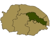
Broadland is a local government district
in Norfolk
, England
, named after the Norfolk Broads. Its council is based in Thorpe St Andrew
, which is a suburb of the City of Norwich
.
, the district had an area of 546 square kilometres (210.8 sq mi), with a population of 118,513 in 50,009 households.
The district contains the following civil parishes:
Non-metropolitan district
Non-metropolitan districts, or colloquially shire districts, are a type of local government district in England. As created, they are sub-divisions of non-metropolitan counties in a so-called "two-tier" arrangement...
in Norfolk
Norfolk
Norfolk is a low-lying county in the East of England. It has borders with Lincolnshire to the west, Cambridgeshire to the west and southwest and Suffolk to the south. Its northern and eastern boundaries are the North Sea coast and to the north-west the county is bordered by The Wash. The county...
, England
England
England is a country that is part of the United Kingdom. It shares land borders with Scotland to the north and Wales to the west; the Irish Sea is to the north west, the Celtic Sea to the south west, with the North Sea to the east and the English Channel to the south separating it from continental...
, named after the Norfolk Broads. Its council is based in Thorpe St Andrew
Thorpe St Andrew
Thorpe St Andrew is a small town and suburb of Norwich in the English county of Norfolk.It is situated about two miles east of the city centre, outside the city boundary in the district of Broadland...
, which is a suburb of the City of Norwich
Norwich
Norwich is a city in England. It is the regional administrative centre and county town of Norfolk. During the 11th century, Norwich was the largest city in England after London, and one of the most important places in the kingdom...
.
History
The district was formed on April 1, 1974 by the merger of St. Faiths and Aylsham Rural District and part of Blofield and Flegg Rural District.Composition
The district is entirely parished, and is made up of 65 civil parishes. At the time of the 2001 censusUnited Kingdom Census 2001
A nationwide census, known as Census 2001, was conducted in the United Kingdom on Sunday, 29 April 2001. This was the 20th UK Census and recorded a resident population of 58,789,194....
, the district had an area of 546 square kilometres (210.8 sq mi), with a population of 118,513 in 50,009 households.
The district contains the following civil parishes:
- AcleAcleAcle is a small market town on the River Bure on The Norfolk Broads in Norfolk, located halfway between Norwich and Great Yarmouth. It has the only bridge across the River Bure between Wroxham and Great Yarmouth. There is a high school Acle is a small market town on the River Bure on The Norfolk...
, AlderfordAlderfordAlderford is a village and civil parish in the English county of Norfolk, about ten miles north-west of Norwich.The civil parish has an area of 1.80 square kilometres and in 2001 had a population of 43 in 16 households...
, AttlebridgeAttlebridgeAttlebridge is a village and civil parish in the English county of Norfolk. It is situated about 8 miles north-west of Norwich, where the A1067 crosses the River Wensum....
, AylshamAylshamAylsham is a historic market town and civil parish on the River Bure in north Norfolk, England, about north of Norwich. The river rises near Melton Constable, upstream from Aylsham and continues to Great Yarmouth and the North Sea, although it was only made navigable after 1779, allowing grain,... - Beeston St. AndrewBeeston St. AndrewBeeston St Andrew is a civil parish in the Broadland district of Norfolk, England, north of Norwich. It contains Beeston Park and according to the 2001 census had a population of 39.It is part of the ecclesiastical parish of Sprowston with Beeston St Andrew....
, BeightonBeighton, NorfolkBeighton is a village and civil parish in the Broadland district of Norfolk, England, about two miles south of Acle. According to the 2001 census it had a population of 412....
, BelaughBelaughBelaugh is a small village that occupies a bend in the River Bure in Norfolk, England - within The Broads National Park. It is accessible via the road between Hoveton and Coltishall or from the river. It contains no pubs, bars or shops...
, BlicklingBlicklingBlickling is a village and civil parish in the Broadland district of Norfolk, England, about north-west of Aylsham on the B1354 road. According to the 2001 census it had a population of 136 and covers . Since the 17th century the village has been concentrated in two areas, around the church and...
, BlofieldBlofieldBlofield is the village and civil parish in the Broadland district of Norfolk, England. The parish includes Blofield and the hamlets of Blofield Heath and Blofield Corner and, according to the 2001 census, had a population of 3,221. It is on the A47, five miles east of Norwich and west of Great...
, BootonBooton, NorfolkBooton is a village and civil parish in the Broadland district of Norfolk, England, just east of Reepham and seven miles west of Aylsham. According to the 2001 census, it had a population of 100.- Notable residents :...
, BramptonBrampton, NorfolkBrampton is a small village and parish in the county of Norfolk, England, in the Bure Valley, east of Aylsham.Brampton station is an intermediate halt on the Bure Valley Railway.Its church, St Peter, is one of 124 existing round-tower churches in Norfolk...
, BrandistonBrandistonBrandiston is a small village and civil parish in the county of Norfolk, England, about two miles south-east of the small market town of Reepham, five miles south-west of the larger town of Aylsham and 10 miles north-west of the city of Norwich. For the purposes of local government, it falls within...
, BrundallBrundallBrundall is a village and civil parish in the English county of Norfolk. It is located on the north bank of the River Yare opposite Surlingham Broad and about 7 miles east of the city of Norwich....
, Burgh and TuttingtonBurgh and TuttingtonBurgh and Tuttington is a civil parish in the English county of Norfolk.It covers an area of and had a population of 255 in 115 households as of the 2001 census.For the purposes of local government, it falls within the district of Broadland...
, Buxton LammasBuxton LammasBuxton with Lammas is a civil parish in Broadland in the English county of Norfolk. It comprises the villages of Buxton lying to the west of the River Bure and Lammas on the eastern side of the river. At this point the River Bure is crossed by the Bure Valley Railway on a long girder bridge. ...
, BuxtonBuxton, NorfolkBuxton is a village in Norfolk, located between Norwich and Aylsham. The village is mentioned in the Domesday Book of 1085. Buxton is adjacent to the village of Lammas. The two villages are separated by the River Bure at Buxton Mill but are otherwise indistinguishable... - CantleyCantley, NorfolkCantley is a village and civil parish in the English county of Norfolk. Cantley is within the Broads Special Protection Area. The village lies on the north bank of the River Yare, some 17 km east of the city of Norwich, 15 km south-west of the town of Great Yarmouth and the same distance...
, CawstonCawston, NorfolkCawston is a small village located approximately North of Norwich, off the B1149 main road to Holt. Nearby villages are Reepham and Aylsham.-Church of St Agnes:...
, ColtishallColtishallColtishall is a village on the River Bure, west of Wroxham, in the English county of Norfolk, within the Norfolk Broads.Coltishall was a place of note even when the Domesday Book was compiled. For 250 years it was a centre of the malting industry...
, CrostwickCrostwickCrostwick is a village and civil parish in the district of Broadland, Norfolk, England.... - DraytonDrayton, NorfolkDrayton, Norfolk, is a suburban village in the county of Norfolk and district of Broadland north west of Norwich. It is situated on the A1067 road between Hellesdon and Taverham.- History :...
- FelthorpeFelthorpeFelthorpe is a civil parish in the English county of Norfolk.It covers an area of and had a population of 710 in 287 households as of the 2001 census.For the purposes of local government, it falls within the district of Broadland....
, FoulshamFoulshamThis article is about the place. For the publishing company see W. Foulsham & Company Limited.Foulsham is a village and civil parish in the English county of Norfolk. The Village is miles west south west of Cromer, miles north west of Norwich and miles north east of London. The village lies...
, FreethorpeFreethorpeFreethorpe is a civil parish in the English county of Norfolk, about south-west of Great Yarmouth. It covers an area of and had a population of 906 in 363 households as of the 2001 census....
, FrettenhamFrettenhamFrettenham is a civil parish in the English county of Norfolk. Known in the Domesday Book as 'Fretham', Frettenham is located six miles north-east of Norwich, surrounded by countryside... - Great Plumstead, Great WitchinghamGreat WitchinghamGreat Witchingham is a village and civil parish in the English county of Norfolk about north-west of Norwich.It covers an area of and had a population of 564 in 235 households as of the 2001 census....
, GuestwickGuestwickGuestwick is a village and a civil parish in the English county of Norfolk. The village is south-west of Cromer, north-west of Norwich and north-east of London. The village lies west of the nearby town of Aylsham. The village lies far from any High roads. The nearest railway station is at... - HainfordHainfordHainford is a village and civil parish in the English county of Norfolk.It covers an area of and had a population of 951 in 365 households as of the 2001 census....
, HalvergateHalvergateHalvergate is a civil parish in the English county of Norfolk, north of Reedham., halfway between the Rivers Bure and Yare, within The Broads National Park.It covers an area of and had a population of 468 in 202 households as of the 2001 census....
, HaveringlandHaveringlandHaveringland is a village and civil parish in the English county of Norfolk about north-west of Norwich.It covers an area of and had a population of 187 in 69 households as of the 2001 census....
, HellesdonHellesdonHellesdon is a thriving suburb of Norwich in the District of Broadland in Norfolk, England. It lies approximately 4 miles north-west of Norwich and has 11,177 inhabitants.- History :...
, HemblingtonHemblingtonHemblington is a civil parish in the English county of Norfolk, about miles east of Norwich.It covers an area of and had a population of 316 in 134 households as of the 2001 census....
, HevinghamHevinghamHevingham is a Norfolk village and civil parish situated between the A140 road Norwich to Cromer road and the B1149 road Norwich to Holt road. It is north from the city of Norwich and south from the market town of Aylsham....
, HeydonHeydon, NorfolkHeydon, Norfolk, is an English village in the county of Norfolk and district of Broadland.Heydon is about five miles north of Reepham, and has no through road, making it isolated except from the south...
, HoninghamHoninghamHoningham is a village and civil parish in the English county of Norfolk, located to the west of Norwich along the A47 trunk road. It covers an area of and had a population of 342 in 145 households as of the 2001 census....
, HorsfordHorsfordHorsford is a village six miles north of Norwich, England. Its population has seen a steady increase since the Second World War, growing from 750 in 1945 to just under 4000 today .There are various explanations of the village name...
, Horsham St Faith, Horsham St Faith and Newton St FaithHorsham St Faith and Newton St FaithHorsham St Faith and Newton St Faith is a civil parish in the English county of Norfolk, consisting of the former parishes of Horsham St Faith and Newton St Faith...
, Horstead with StanninghallHorstead with StanninghallHorstead with Stanninghall is a civil parish in the English county of Norfolk, consisting of the former parishes of Horstead and Stanninghall.It covers an area of and had a population of 1007 in 435 households as of the 2001 census.... - Lingwood and BurlinghamLingwood and BurlinghamLingwood and Burlingham is a civil parish in the English county of Norfolk, comprising the large village of Lingwood together with the smaller villages of Burlingham Green, North Burlingham and South Burlingham...
, Little PlumsteadLittle PlumsteadLittle Plumstead is a small village and parish in the county of Norfolk, England, about six miles east of Norwich.It is the home of Little Plumstead Hospital.Its church, St Protase and St Gervase, is one of 124 existing round-tower churches in Norfolk....
, Little WitchinghamLittle WitchinghamLittle Witchingham is a village and civil parish in the English county of Norfolk.It covers an area of and had a population of 36 in 14 households as of the 2001 census.For the purposes of local government, it falls within the district of Broadland.... - MarshamMarsham, NorfolkMarsham is a civil parish in the English county of Norfolk, about north of Norwich.It covers an area of and had a population of 674 in 282 households as of the 2001 census.For the purposes of local government, it falls within the district of Broadland....
, Morton on the HillMorton on the HillMorton on the Hill is a small but scattered village and civil parish in the English county of Norfolk, about north-west of Norwich.It covers an area of and had a population of 85 in 34 households as of the 2001 census.... - Old CattonOld CattonOld Catton is a suburban village and civil parish in the English county of Norfolk which lies to the north-east of central Norwich. The parish is bounded by the Norwich International Airport at Hellesdon to the west and Sprowston to the east...
, OultonOulton, NorfolkOulton is a civil parish in the English county of Norfolk.It covers an area of and had a population of 196 in 74 households as of the 2001 census.For the purposes of local government, it falls within the district of Broadland.... - Postwick with WittonPostwick with WittonPostwick with Witton is a civil parish on the Broads in the English county of Norfolk, comprising the two nearby villages of Postwick and Witton. Postwick is some east of the city of Norwich, just south of the eastern end of the A47 Norwich southern bypass on the north bank of the River Yare...
- RackheathRackheathRackheath is a civil parish in the English county of Norfolk, and is roughly outside of Norwich City Centre.It covers an area of and had a population of 1,551 in 625 households as of the 2001 census....
, ReedhamReedham, NorfolkReedham is a village and civil parish in the English county of Norfolk and within The Broads. It is situated on the north bank of the River Yare, some east of the city of Norwich, south-west of the town of Great Yarmouth and the same distance north-west of the Suffolk town of Lowestoft.The Romans...
, Reepham, RinglandRingland, NorfolkRingland is a rural village in Norfolk, England, situated in the valley of the River Wensum, approximately north-west of Norwich... - SalhouseSalhouseSalhouse is a village and civil parish within The Broads National Park in the English county of Norfolk. It lies south of the River Bure and Salhouse Broad, about north-east of Norwich....
, SalleSalleSalle is a village and civil parish in the English county of Norfolk.The civil parish has an area of and in 2001 had a population of 50 in 21 households...
, South WalshamSouth WalshamSouth Walsham is a village and civil parish in the English county of Norfolk. It is adjacent to South Walsham Broad.It covers an area of and had a population of 738 in 303 households as of the 2001 census....
, SpixworthSpixworthSpixworth is a civil parish in the English county of Norfolk. The village lies close to the B1150 road and is north of Norwich and some south of North Walsham.It covers an area of and had a population of 3,769 in 1,508 households as of the 2001 census....
, SprowstonSprowstonSprowston is a small town bordering Norwich in Norfolk, England. It is bounded by Heartsease to the east, Mousehold Heath and the suburb of New Sprowston to the south , Old Catton to the west, and by the open farmland of Beeston St Andrew to the north.It was the largest parish in Norfolk and the...
, Stratton StrawlessStratton StrawlessStratton Strawless is a village in the county of Norfolk and district of Broadland. The civil parish covers and has a population of 495. Located close and to the east of the A140 road and being south of the market town of Aylsham and some north of Norwich...
, StrumpshawStrumpshawStrumpshaw is a village and civil parish in the English county of Norfolk, on the River Yare in Norfolk, England, within The Broads National Park.It covers an area of and had a population of 602 in 245 households as of the 2001 census....
, SwanningtonSwannington, NorfolkSwannington is a village and civil parish in the English county of Norfolk. The village is located approximately north of Norwich between the villages of Taverham, Felthorpe, Brandiston and Cawston.... - TaverhamTaverhamTaverham is a village and civil parish in Norfolk, in the UK. It is approximately 5 miles north-west of the City of Norwich. Taverham sits on the River Wensum.In 2001, Taverham had a population of 10,233...
, ThemelthorpeThemelthorpeThemelthorpe is a civil parish in the English county of Norfolk, north west of Reepham.It covers an area of and had a population of 65 in 27 households as of the 2001 census.For the purposes of local government, it falls within the district of Broadland....
, Thorpe St. AndrewThorpe St AndrewThorpe St Andrew is a small town and suburb of Norwich in the English county of Norfolk.It is situated about two miles east of the city centre, outside the city boundary in the district of Broadland... - Upton with FishleyUpton with FishleyUpton with Fishley is a civil parish in the English county of Norfolk, consisting of the former parishes of Upton and Fishley.It covers an area of and had a population of 660 in 272 households as of the 2001 census....
- Weston LongvilleWeston LongvilleWeston Longville is a civil parish in the English county of Norfolk, approximately north-west of Norwich. Its name is derived from the Manor of Longaville in Normandy, France, which owned the local land in the 12th century....
, WoodbastwickWoodbastwickWoodbastwick is a village and civil parish in the English county of Norfolk. It is located on the River Bure between Cockshoot Broad and Salhouse Broad, within The Broads National Park and close to Bure Marshes NNR . The city of Norwich lies to the south-east.The village name relates to bast, a...
, Wood DallingWood DallingWood Dalling is a village and civil parish in the English county of Norfolk. It is situated some east of Fakenham, south-west of Cromer, and north-west of Norwich....
, WroxhamWroxhamWroxham is a village and civil parish in the English county of Norfolk. The civil parish of Wroxham has an area of 6.21 square kilometres and in 2001 had a population of 1532 in 666 households. The village is situated within the Norfolk Broads on the south side of a loop in the middle reaches of...