

Wishram, Washington
Encyclopedia
Wishram is a census-designated place
(CDP) in Klickitat County, Washington, United States
. The population was 213 at the 2000 census. The site of the historic Celilo Falls
is nearby.
The community was originally named Fallbridge; it was changed to Wishram to honor the Wishram
tribe of Native Americans
. The nearby Dalles Dam was completed in 1957, and began filling Lake Celilo
. The original fishing village near this location was inundated.
According to the United States Census Bureau
, the CDP has a total area of 1.3 square miles (3.3 km²), all of it land.
Wishram lies toward the upper end of the Columbia River Gorge
, which began forming as far back as the Miocene
, (roughly 12 - 17 million years ago) depositing thick layers of Columbia River Basalt
, and continued to take shape through the Pleistocene
, (700,000 - 2 million years ago). During this period the Cascades Range was forming, slowly moving the Columbia River's course north to its current location.
Although the river slowly eroded the land over this period of time, the most drastic changes took place at the end of the last Ice Age
when the Missoula Floods
cut the steep, dramatic walls that exist around Wishram today. During the flood, the water level rose to 700 feet above the current level, violently eroding and exposing the layered basalt. This quick erosion left many layers of volcanic rock
exposed.
of 2000, there were 213 people, 122 households, and 89 families residing in the CDP. The population density
was 254.2 people per square mile (98.5/km²). There were 122 housing units at an average density of 152.2/sq mi (59.0/km²). The racial makeup of the CDP was 75.10% White, 12.30% African American, 9.26% Native American, 3.09% from other races
, and 2.78% from two or more races. Hispanic or Latino of any race were 3.09% of the population.
There were 122 households out of which 21.7% had children under the age of 18 living with them, 40.1% were married couples
living together, 13.2% had a female householder with no husband present, and 41.4% were non-families. 36.8% of all households were made up of individuals and 16.4% had someone living alone who was 65 years of age or older. The average household size was 2.13 and the average family size was 2.74.
In the CDP the population was spread out with 25.0% under the age of 18, 5.2% from 18 to 24, 25.0% from 25 to 44, 25.3% from 45 to 64, and 19.4% who were 65 years of age or older. The median age was 41 years. For every 100 females there were 110.4 males. For every 100 females age 18 and over, there were 99.2 males.
The median income for a household in the CDP was $26,667, and the median income for a family was $23,750. Males had a median income of $31,042 versus $23,229 for females. The per capita income
for the CDP was $15,414. About 27.7% of families and 26.3% of the population were below the poverty line, including 43.3% of those under age 18 and 9.3% of those age 65 or over.
on the Columbia, and as a result has been populated for an extended period. For ~ 15,000 years, native peoples
gathered to fish and exchange goods. They built wooden platforms out over the water and caught salmon
with dipnets and long spears on poles as the fish swam up through the rapids and jumped over the falls. Celilo Falls and The Dalles were strategically located at the border between Chinookan
and Sahaptian speaking peoples and served as the center of an extensive trading network across the Pacific Plateau. It was noted by early explorers and historians of the area.
In 1892 the U.S. government completed a set of locks to bypass Celilo Falls on the southern shore, across from Wishram. Built at a cost of $5,000,000 these locks saw limited service as much of the freight in and out of the Pacific Northwest began to travel by rail.
In 1912 the unincorporated town was then known as Fallbridge, named in recognition of the southern extension of the Spokane, Portland and Seattle Railway, which crossed the Columbia on the Oregon Trunk Rail Bridge
constructed on the basalt rock of Celilo Falls.
By the time the returned on 16 April 1806, they reported the village have moved about 300 yards below the spot where it had been located the previous fall, and tended to move with the favored fishing locations.
, also mentioned the native Americans resident at Wishram in his history of the Northwest titled Astoria Or, Anecdotes Of An Enterprise Beyond The Rocky Mountains and published in 1836. He stated:
Wishram is extensively mentioned in regional histories and travelogues of the early 19th century. Visitors included Thomas Farnham
, Hudson Bay Company Governor Sir George Simpson, Alexander Ross
, Father Pierre Desmet
and Joseph Drayton's party of the Wilkes Expedition, among others. Ross reported that at Wishram the summer encampments when the Salmon were runnning could swell to 3,000 natives. Father Desmet described it as a glorious time of rejoicing, gambling and feasting.
There have been village sites at the Wishram location for millennia. Archeologists in the 1950s identified a multilevel site with centuries of waste accumulated in middens as well as petroglyphs and other indications of dense population. Most of the densely populated areas were close to the river and convenient to fishing. This lower area was flooded in 1957 by water backed up behind The Dalles Dam.
In 1926 a pioneer memorial was raised at Wishram/Fallbridge. Still located in its original position 100 feet east of the passenger train station today, it consists of two columns of basalt bound together with iron straps and mounted on a pedestal. A bronze plaque recognizing various pioneers who have been to Wishram begins with Meriwether Lewis and ends with John C. Fremont
. It originally marked the beginning of a 1/2 mile path from that monument to Celilo Falls; that path is now covered by the backwaters from The Dalles Dam.
was chartered in 1905 by James J. Hill
for the purposes of connecting the two transcontinental railroads owned by him, the Northern Pacific
and Great Northern, to Portland
, Oregon
from Spokane
, Washington, in order to gain a portion of the lumber trade in Oregon, a business that at the time was dominated by E.H. Harriman's Union Pacific
and Southern Pacific railroads. Construction began in 1906 under the name Portland & Seattle Railway, proceeding eastward from Vancouver, Washington
. 1906 also saw the start of construction of the line between Vancouver and Portland. This railroad included the first bridge of any kind to be built across the lower Columbia River
.
 Within a year, and despite legal challenges from Harriman, who wished to block its construction, the line had been built as far as Pasco, Washington
along the Columbia River, where there was a connection with Northern Pacific lines. The first section to open was from Pasco west through Wishram to cliffs (near Maryhill), a length of 112 miles (180.2 km), on December 15, 1907. Operation was extended west to Lyle
, another 145 miles (233.4 km), on January 15, 1908, as construction continued on the 221 miles (355.7 km) section from there to Vancouver.
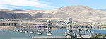
The town of Wishram (then known as Fallbridge) was fortuitously situated at a location which made bridging the Columbia River relatively easy. It was possible to construct a bridge that had piers resting on normally exposed basalt rock above the water fall during low water periods such that during periods of high water, when this stretch of the Columbia River became raging rapids, the piers supported a bridge spanning the entire flood. This bridge over Celilo Falls became known as the Oregon Trunk Rail Bridge
or the fallbridge. The location of this bridge also allowed construction of rail along the Deschutes River canyon, allowing access to eastern Oregon's high desert plateau and eastern Cascade Mountains.
As a result, the SP&S was extended southward from Wishram, Washington toward Bend, Oregon
. Hill and Harriman engaged in a head-to-head battle up the Des Chutes grade, with intense competition for any advantageous routing. After the competition reached what has been described as ridiculous levels, Hariman died in 1909 and an agreement that this extension was to be jointly operated with a Union Pacific subsidiary, the Oregon-Washington Railway & Navigation, was reached. This southern extension relied upon the Oregon Trunk Rail Bridge - the "fall bridge" - constructed just downstream of Wishram at the waterfall on the Columbia. James J. Hill inaugurated this route, driving a golden spike in Bend in 1912. Fallbridge served as a passenger terminal, roundhouse and freight switch yard for traffic into Bend. Recognizing its central location, a 300-ton automatic coaling station was erected for the Spokane, Portland & Seattle Railroad at Fallbridge in 1920.
The name was officially changed to Wishram in 1926. However, the name of Fallbridge continues to appear in various documents. In 1931 the official schedules for the railway used "Wishram (Fallbridge)" as the designation for the stop at Wishram. The town still appears as Fallbridge in 1940 U.S. Army. Corps of Engineers port directories, and in 1941 in standard textbooks.
In 1931 the SP&S line to Bend was connected via Klamath Falls, Oregon
to Bieber, California
, providing a shortcut to connect with the Western Pacific Railroad
in Northern California.
Wishram is a hub for train traffic coming north from Oregon and California, as well as those coming west. The section of railroad that runs from Vancouver
to Pasco
still bears the towns' original name of Fallbridge.
Census-designated place
A census-designated place is a concentration of population identified by the United States Census Bureau for statistical purposes. CDPs are delineated for each decennial census as the statistical counterparts of incorporated places such as cities, towns and villages...
(CDP) in Klickitat County, Washington, United States
United States
The United States of America is a federal constitutional republic comprising fifty states and a federal district...
. The population was 213 at the 2000 census. The site of the historic Celilo Falls
Celilo Falls
Celilo Falls was a tribal fishing area on the Columbia River, just east of the Cascade Mountains, on what is today the border between the U.S. states of Oregon and Washington...
is nearby.
The community was originally named Fallbridge; it was changed to Wishram to honor the Wishram
Wasco-Wishram
Wasco-Wishram are two closely related Chinook Indian tribes from the Columbia River in Oregon. Today the tribes are part of the Warm Springs Reservation in Oregon and Confederated Tribes and Bands of the Yakama Nation in Washington.-History:...
tribe of Native Americans
Native Americans in the United States
Native Americans in the United States are the indigenous peoples in North America within the boundaries of the present-day continental United States, parts of Alaska, and the island state of Hawaii. They are composed of numerous, distinct tribes, states, and ethnic groups, many of which survive as...
. The nearby Dalles Dam was completed in 1957, and began filling Lake Celilo
Lake Celilo
Lake Celilo is a long reservoir on the Columbia River in the United States, between the U.S. states of Washington and Oregon. It was created in 1957 with the construction of The Dalles Dam near The Dalles, Oregon, and stretches upstream to the John Day Dam. Its filling drowned the former site of...
. The original fishing village near this location was inundated.
Geography
Wishram is located at 45°39′40"N 120°57′32"W (45.661198, -120.958788).According to the United States Census Bureau
United States Census Bureau
The United States Census Bureau is the government agency that is responsible for the United States Census. It also gathers other national demographic and economic data...
, the CDP has a total area of 1.3 square miles (3.3 km²), all of it land.
Geology
Wishram's location results from two major geological features: the location of the Celilo Falls on the Columbia River, and the access to the Central Oregon Plateau via the Deschutes River just across the falls from Wishram. The falls not only provided early peoples a reliable source of food, but it later provided a convenient location for an easily constructed railroad bridge crossing the Columbia. The Deschutes valley just to the south of the falls provided a route for rail access to the south, and ultimately to California.Wishram lies toward the upper end of the Columbia River Gorge
Columbia River Gorge
The Columbia River Gorge is a canyon of the Columbia River in the Pacific Northwest of the United States. Up to deep, the canyon stretches for over as the river winds westward through the Cascade Range forming the boundary between the State of Washington to the north and Oregon to the south...
, which began forming as far back as the Miocene
Miocene
The Miocene is a geological epoch of the Neogene Period and extends from about . The Miocene was named by Sir Charles Lyell. Its name comes from the Greek words and and means "less recent" because it has 18% fewer modern sea invertebrates than the Pliocene. The Miocene follows the Oligocene...
, (roughly 12 - 17 million years ago) depositing thick layers of Columbia River Basalt
Columbia River Basalt Group
The Columbia River Basalt Group is a large igneous province that lies across parts of the Western United States. It is found in the U.S. states of Washington, Oregon, Idaho, Nevada, and California...
, and continued to take shape through the Pleistocene
Pleistocene
The Pleistocene is the epoch from 2,588,000 to 11,700 years BP that spans the world's recent period of repeated glaciations. The name pleistocene is derived from the Greek and ....
, (700,000 - 2 million years ago). During this period the Cascades Range was forming, slowly moving the Columbia River's course north to its current location.
Although the river slowly eroded the land over this period of time, the most drastic changes took place at the end of the last Ice Age
Ice age
An ice age or, more precisely, glacial age, is a generic geological period of long-term reduction in the temperature of the Earth's surface and atmosphere, resulting in the presence or expansion of continental ice sheets, polar ice sheets and alpine glaciers...
when the Missoula Floods
Missoula Floods
The Missoula Floods refer to the cataclysmic floods that swept periodically across eastern Washington and down the Columbia River Gorge at the end of the last ice age. The glacial flood events have been researched since the 1920s...
cut the steep, dramatic walls that exist around Wishram today. During the flood, the water level rose to 700 feet above the current level, violently eroding and exposing the layered basalt. This quick erosion left many layers of volcanic rock
Igneous rock
Igneous rock is one of the three main rock types, the others being sedimentary and metamorphic rock. Igneous rock is formed through the cooling and solidification of magma or lava...
exposed.
Demographics
As of the censusCensus
A census is the procedure of systematically acquiring and recording information about the members of a given population. It is a regularly occurring and official count of a particular population. The term is used mostly in connection with national population and housing censuses; other common...
of 2000, there were 213 people, 122 households, and 89 families residing in the CDP. The population density
Population density
Population density is a measurement of population per unit area or unit volume. It is frequently applied to living organisms, and particularly to humans...
was 254.2 people per square mile (98.5/km²). There were 122 housing units at an average density of 152.2/sq mi (59.0/km²). The racial makeup of the CDP was 75.10% White, 12.30% African American, 9.26% Native American, 3.09% from other races
Race (United States Census)
Race and ethnicity in the United States Census, as defined by the Federal Office of Management and Budget and the United States Census Bureau, are self-identification data items in which residents choose the race or races with which they most closely identify, and indicate whether or not they are...
, and 2.78% from two or more races. Hispanic or Latino of any race were 3.09% of the population.
There were 122 households out of which 21.7% had children under the age of 18 living with them, 40.1% were married couples
Marriage
Marriage is a social union or legal contract between people that creates kinship. It is an institution in which interpersonal relationships, usually intimate and sexual, are acknowledged in a variety of ways, depending on the culture or subculture in which it is found...
living together, 13.2% had a female householder with no husband present, and 41.4% were non-families. 36.8% of all households were made up of individuals and 16.4% had someone living alone who was 65 years of age or older. The average household size was 2.13 and the average family size was 2.74.
In the CDP the population was spread out with 25.0% under the age of 18, 5.2% from 18 to 24, 25.0% from 25 to 44, 25.3% from 45 to 64, and 19.4% who were 65 years of age or older. The median age was 41 years. For every 100 females there were 110.4 males. For every 100 females age 18 and over, there were 99.2 males.
The median income for a household in the CDP was $26,667, and the median income for a family was $23,750. Males had a median income of $31,042 versus $23,229 for females. The per capita income
Per capita income
Per capita income or income per person is a measure of mean income within an economic aggregate, such as a country or city. It is calculated by taking a measure of all sources of income in the aggregate and dividing it by the total population...
for the CDP was $15,414. About 27.7% of families and 26.3% of the population were below the poverty line, including 43.3% of those under age 18 and 9.3% of those age 65 or over.
History
The area of Wishram was located 1/2 mile above the head of the great Celilo FallsCelilo Falls
Celilo Falls was a tribal fishing area on the Columbia River, just east of the Cascade Mountains, on what is today the border between the U.S. states of Oregon and Washington...
on the Columbia, and as a result has been populated for an extended period. For ~ 15,000 years, native peoples
Native Americans in the United States
Native Americans in the United States are the indigenous peoples in North America within the boundaries of the present-day continental United States, parts of Alaska, and the island state of Hawaii. They are composed of numerous, distinct tribes, states, and ethnic groups, many of which survive as...
gathered to fish and exchange goods. They built wooden platforms out over the water and caught salmon
Salmon
Salmon is the common name for several species of fish in the family Salmonidae. Several other fish in the same family are called trout; the difference is often said to be that salmon migrate and trout are resident, but this distinction does not strictly hold true...
with dipnets and long spears on poles as the fish swam up through the rapids and jumped over the falls. Celilo Falls and The Dalles were strategically located at the border between Chinookan
Chinookan languages
Chinookan is a small family of languages spoken in Oregon and Washington along the Columbia River by Chinook peoples.-Family division:Chinookan languages consists of three languages with multiple varieties. There is some dispute over classification, and there are two ISO 639-3 codes assigned: and...
and Sahaptian speaking peoples and served as the center of an extensive trading network across the Pacific Plateau. It was noted by early explorers and historians of the area.
In 1892 the U.S. government completed a set of locks to bypass Celilo Falls on the southern shore, across from Wishram. Built at a cost of $5,000,000 these locks saw limited service as much of the freight in and out of the Pacific Northwest began to travel by rail.
In 1912 the unincorporated town was then known as Fallbridge, named in recognition of the southern extension of the Spokane, Portland and Seattle Railway, which crossed the Columbia on the Oregon Trunk Rail Bridge
Oregon Trunk Rail Bridge
The Oregon Trunk Rail Bridge or Celilo Bridge is a railroad bridge built in 1912 over the Columbia River in the Pacific Northwest of the United States. It consists of eight steel truss spans and several deck girder spans, and includes a vertical-lift section.It is part of the Wishram, Washington...
constructed on the basalt rock of Celilo Falls.
Lewis and Clark
Lewis and Clark mentioned the site of Wishram in their journal. In his journal for 22 October 1805, Clark recorded:"below this Island on the main Stard Shore is 16 Lodges of nativs; here we landed a fiew minits to Smoke, the lower point of one Island opposit which heads in the mouth of Towarnehiooks River (Deschutes River) which I did not observe untill after passing these lodges about 1/2 a mile lower passed 6 more Lodges on the Same Side and 6 miles below the upper mouth of Towarnehiooks River the comencement of the pitch of the Great falls, opposit on the Stard. Side (Starboard or right side) is 17 Lodges (archaeologists have identified this as modern Wishram) of the nativs we landed and walked down accompanied by an old man to view the falls, and the best rout for to make a portage which we Soon discovered was much nearest on the Stard. Side, and the distance 1200 yards one third of the way on a rock, about 200 yards over a loose Sand collected in a hollar blown by the winds from the bottoms below which was disagreeable to pass, as it was Steep and loose. at the lower part of those rapids we arrived at 5 Large Lodges of nativs drying and prepareing fish for market, they gave us Philburts, and berries to eate, we returned droped down to the head of the rapids and took every article except the Canoes across the portag where I had formed a camp on ellegable Situation for the protection of our Stores from Thieft, which we were more fearfull of, than their arrows. we despatched two men to examine the river on the opposit Side, and reported that the Canoes could be taken down a narrow Chanel on the opposit Side after a Short portage at the head of the falls, at which place the Indians take over their Canoes. Indians assisted us over the portage with our heavy articles on their horses, the waters is divided into Several narrow chanels which pass through a hard black rock forming Islands of rocks at this Stage of the water, on those Islands of rocks as well as at and about their Lodges I observe great numbers of Stacks of pounded Salmon neetly preserved in the following manner, i e after Suffiently Dried it is pounded between two Stones fine, and put into a speces of basket neetly made of grass and rushes of better than two feet long and one foot Diamiter, which basket is lined with the Skin of Salmon Stretched and dried for the purpose, in theis it is pressed down as hard as is possible, when full they Secure the open part with the fish Skins across which they fasten tho the loops of the basket that part very Securely, and then on a Dry Situation they Set those baskets the Corded part up, their common Custom is to Set 7 as close as they can Stand and 5 on the top of them, and secure them with mats which is raped around them and made fast with cords and Covered also with mats, those 12 baskets of from 90 to 100 w. each form a Stack. thus preserved those fish may be kept Sound and Sweet Several years, as those people inform me, Great quantities as they inform us are Sold to the whites people who visit the mouth of this river as well as to the nativs below."
By the time the returned on 16 April 1806, they reported the village have moved about 300 yards below the spot where it had been located the previous fall, and tended to move with the favored fishing locations.
Early history
The American author, Washington IrvingWashington Irving
Washington Irving was an American author, essayist, biographer and historian of the early 19th century. He was best known for his short stories "The Legend of Sleepy Hollow" and "Rip Van Winkle", both of which appear in his book The Sketch Book of Geoffrey Crayon, Gent. His historical works...
, also mentioned the native Americans resident at Wishram in his history of the Northwest titled Astoria Or, Anecdotes Of An Enterprise Beyond The Rocky Mountains and published in 1836. He stated:
"For like reason we would make especial mention of the village of Wishram, at the head of the Long Narrows, as being a solitary instance of an aboriginal trading mart, or emporium. Here the salmon caught in the neighboring rapids were "warehoused," to await customers. Hither the tribes from the mouth of the Columbia repaired with the fish of the sea-coast, the roots, berries, and especially the wappatoo, gathered in the lower parts of the river, together with goods and trinkets obtained from the ships which casually visit the coast. Hither also the tribes from the Rocky Mountains brought down horses, bear-grass, quamash, and other commodities of the interior. The merchant fishermen at the falls acted as middlemen or factors, and passed the objects of traffic, as it were, cross-handed; trading away part of the wares received from the mountain tribes to those of the rivers and plains, and vice versa: their packages of pounded salmon entered largely into the system of barter, and being carried off in opposite directions, found their way to the savage hunting camps far in the interior, and to the casual white traders who touched upon the coast."
Wishram is extensively mentioned in regional histories and travelogues of the early 19th century. Visitors included Thomas Farnham
Thomas J. Farnham
Thomas Jefferson Farnham was an explorer and author of the American West in the first half of the 19th Century. His travels included interaction with missionary Jason Lee, and he later led a wagon train on the Oregon Trail...
, Hudson Bay Company Governor Sir George Simpson, Alexander Ross
Alexander Ross (fur trader)
-Fur trader and explorer:Ross emigrated to Upper Canada, present day , from Scotland about 1805.In 1811, while working for John Jacob Astor's Pacific Fur Company, Ross took part in the founding of Fort Astoria, a fur-trading post at the mouth of the Columbia River...
, Father Pierre Desmet
Pierre-Jean De Smet
Pierre-Jean De Smet , also known as Pieter-Jan De Smet, was a Belgian Roman Catholic priest and member of the Society of Jesus , active in missionary work among the Native Americans of the Midwestern United States in the mid-19th century.His extensive travels as a missionary were said to total...
and Joseph Drayton's party of the Wilkes Expedition, among others. Ross reported that at Wishram the summer encampments when the Salmon were runnning could swell to 3,000 natives. Father Desmet described it as a glorious time of rejoicing, gambling and feasting.
There have been village sites at the Wishram location for millennia. Archeologists in the 1950s identified a multilevel site with centuries of waste accumulated in middens as well as petroglyphs and other indications of dense population. Most of the densely populated areas were close to the river and convenient to fishing. This lower area was flooded in 1957 by water backed up behind The Dalles Dam.
In 1926 a pioneer memorial was raised at Wishram/Fallbridge. Still located in its original position 100 feet east of the passenger train station today, it consists of two columns of basalt bound together with iron straps and mounted on a pedestal. A bronze plaque recognizing various pioneers who have been to Wishram begins with Meriwether Lewis and ends with John C. Fremont
John C. Frémont
John Charles Frémont , was an American military officer, explorer, and the first candidate of the anti-slavery Republican Party for the office of President of the United States. During the 1840s, that era's penny press accorded Frémont the sobriquet The Pathfinder...
. It originally marked the beginning of a 1/2 mile path from that monument to Celilo Falls; that path is now covered by the backwaters from The Dalles Dam.
Wishram/Fallbridge as a rail center
The Spokane, Portland and Seattle RailwaySpokane, Portland and Seattle Railway
The Spokane, Portland and Seattle Railway was a United States-based railroad incorporated in 1905. It was a joint venture by the Great Northern Railway and the Northern Pacific Railway to build a railroad along the north bank of the Columbia River....
was chartered in 1905 by James J. Hill
James J. Hill
James Jerome Hill , was a Canadian-American railroad executive. He was the chief executive officer of a family of lines headed by the Great Northern Railway, which served a substantial area of the Upper Midwest, the northern Great Plains, and Pacific Northwest...
for the purposes of connecting the two transcontinental railroads owned by him, the Northern Pacific
Northern Pacific Railway
The Northern Pacific Railway was a railway that operated in the west along the Canadian border of the United States. Construction began in 1870 and the main line opened all the way from the Great Lakes to the Pacific when former president Ulysses S. Grant drove in the final "golden spike" in...
and Great Northern, to Portland
Portland, Oregon
Portland is a city located in the Pacific Northwest, near the confluence of the Willamette and Columbia rivers in the U.S. state of Oregon. As of the 2010 Census, it had a population of 583,776, making it the 29th most populous city in the United States...
, Oregon
Oregon
Oregon is a state in the Pacific Northwest region of the United States. It is located on the Pacific coast, with Washington to the north, California to the south, Nevada on the southeast and Idaho to the east. The Columbia and Snake rivers delineate much of Oregon's northern and eastern...
from Spokane
Spokane, Washington
Spokane is a city located in the Northwestern United States in the state of Washington. It is the largest city of Spokane County of which it is also the county seat, and the metropolitan center of the Inland Northwest region...
, Washington, in order to gain a portion of the lumber trade in Oregon, a business that at the time was dominated by E.H. Harriman's Union Pacific
Union Pacific Railroad
The Union Pacific Railroad , headquartered in Omaha, Nebraska, is the largest railroad network in the United States. James R. Young is president, CEO and Chairman....
and Southern Pacific railroads. Construction began in 1906 under the name Portland & Seattle Railway, proceeding eastward from Vancouver, Washington
Vancouver, Washington
Vancouver is a city on the north bank of the Columbia River in the U.S. state of Washington. Incorporated in 1857, it is the fourth largest city in the state with a 2010 census population of 161,791 as of April 1, 2010...
. 1906 also saw the start of construction of the line between Vancouver and Portland. This railroad included the first bridge of any kind to be built across the lower Columbia River
Columbia River
The Columbia River is the largest river in the Pacific Northwest region of North America. The river rises in the Rocky Mountains of British Columbia, Canada, flows northwest and then south into the U.S. state of Washington, then turns west to form most of the border between Washington and the state...
.
Pasco, Washington
Pasco is a city in and the county seat of Franklin County, Washington, United States.Pasco is one of three cities that make up the Tri-Cities region of the state of Washington...
along the Columbia River, where there was a connection with Northern Pacific lines. The first section to open was from Pasco west through Wishram to cliffs (near Maryhill), a length of 112 miles (180.2 km), on December 15, 1907. Operation was extended west to Lyle
Lyle, Washington
Lyle is a census-designated place in Klickitat County, Washington, United States. The population was 530 at the 2000 census.- History :...
, another 145 miles (233.4 km), on January 15, 1908, as construction continued on the 221 miles (355.7 km) section from there to Vancouver.
The town of Wishram (then known as Fallbridge) was fortuitously situated at a location which made bridging the Columbia River relatively easy. It was possible to construct a bridge that had piers resting on normally exposed basalt rock above the water fall during low water periods such that during periods of high water, when this stretch of the Columbia River became raging rapids, the piers supported a bridge spanning the entire flood. This bridge over Celilo Falls became known as the Oregon Trunk Rail Bridge
Oregon Trunk Rail Bridge
The Oregon Trunk Rail Bridge or Celilo Bridge is a railroad bridge built in 1912 over the Columbia River in the Pacific Northwest of the United States. It consists of eight steel truss spans and several deck girder spans, and includes a vertical-lift section.It is part of the Wishram, Washington...
or the fallbridge. The location of this bridge also allowed construction of rail along the Deschutes River canyon, allowing access to eastern Oregon's high desert plateau and eastern Cascade Mountains.
As a result, the SP&S was extended southward from Wishram, Washington toward Bend, Oregon
Bend, Oregon
Bend is a city in and the county seat of Deschutes County, Oregon, United States, and the principal city of the Bend, Oregon Metropolitan Statistical Area. Bend is Central Oregon's largest city, and, despite its modest size, is the de facto metropolis of the region, owing to the low population...
. Hill and Harriman engaged in a head-to-head battle up the Des Chutes grade, with intense competition for any advantageous routing. After the competition reached what has been described as ridiculous levels, Hariman died in 1909 and an agreement that this extension was to be jointly operated with a Union Pacific subsidiary, the Oregon-Washington Railway & Navigation, was reached. This southern extension relied upon the Oregon Trunk Rail Bridge - the "fall bridge" - constructed just downstream of Wishram at the waterfall on the Columbia. James J. Hill inaugurated this route, driving a golden spike in Bend in 1912. Fallbridge served as a passenger terminal, roundhouse and freight switch yard for traffic into Bend. Recognizing its central location, a 300-ton automatic coaling station was erected for the Spokane, Portland & Seattle Railroad at Fallbridge in 1920.
The name was officially changed to Wishram in 1926. However, the name of Fallbridge continues to appear in various documents. In 1931 the official schedules for the railway used "Wishram (Fallbridge)" as the designation for the stop at Wishram. The town still appears as Fallbridge in 1940 U.S. Army. Corps of Engineers port directories, and in 1941 in standard textbooks.
In 1931 the SP&S line to Bend was connected via Klamath Falls, Oregon
Klamath Falls, Oregon
Klamath Falls is a city in Klamath County, Oregon, United States. Originally called Linkville when George Nurse founded the town in 1867, after the Link River on whose falls this city sat, although no falls currently exist; the name was changed to Klamath Falls in 1892...
to Bieber, California
Bieber, California
Bieber is a census-designated place in Lassen County, California. It is located on the Pit River north-northwest of Susanville, at an elevation of 4124 feet . Its population was 312 at the 2010 census. The ZIP Code is 96009. The community is inside area code 530.-History:The settlement sprang up...
, providing a shortcut to connect with the Western Pacific Railroad
Western Pacific Railroad
The Western Pacific Railroad was a Class I railroad in the United States. It was formed in 1903 as an attempt to break the near-monopoly the Southern Pacific Railroad had on rail service into northern California...
in Northern California.
Transportation
- Wishram (Amtrak station)Wishram (Amtrak station)Wishram, Washington is a station stop for the Amtrak Empire Builder in Wishram, Washington. The station, parking, track, and platforms are owned by BNSF Railway....
Wishram is a hub for train traffic coming north from Oregon and California, as well as those coming west. The section of railroad that runs from Vancouver
Vancouver, Washington
Vancouver is a city on the north bank of the Columbia River in the U.S. state of Washington. Incorporated in 1857, it is the fourth largest city in the state with a 2010 census population of 161,791 as of April 1, 2010...
to Pasco
Pasco, Washington
Pasco is a city in and the county seat of Franklin County, Washington, United States.Pasco is one of three cities that make up the Tri-Cities region of the state of Washington...
still bears the towns' original name of Fallbridge.