
Whin Rigg
Encyclopedia
Fell
“Fell” is a word used to refer to mountains, or certain types of mountainous landscape, in Scandinavia, the Isle of Man, and parts of northern England.- Etymology :...
is the English Lake District
Lake District
The Lake District, also commonly known as The Lakes or Lakeland, is a mountainous region in North West England. A popular holiday destination, it is famous not only for its lakes and its mountains but also for its associations with the early 19th century poetry and writings of William Wordsworth...
, situated in the western segment of the national park, 22 kilometres south east of the town of Whitehaven
Whitehaven
Whitehaven is a small town and port on the coast of Cumbria, England, which lies equidistant between the county's two largest settlements, Carlisle and Barrow-in-Furness, and is served by the Cumbrian Coast Line and the A595 road...
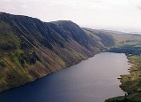
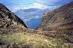
. It reaches only a modest altitude of 535 m (1,755 ft) but is part of one of the Lake District’s most dramatic landscapes in that the rugged and impressive Wastwater Screes (sometimes known as The Screes) fall from the fells summit to Wast Water
Wast Water
Wast Water or Wastwater is a lake located in Wasdale, a valley in the western part of the Lake District National Park, England. The lake is approximately 4.6 kilometres long and 600 metres wide. It is the deepest lake in England at 79 metres , and is owned by the National Trust...
over 450 m (1,500 ft) below. The fells name means “gorse
Gorse
Gorse, furze, furse or whin is a genus of about 20 plant species of thorny evergreen shrubs in the subfamily Faboideae of the pea family Fabaceae, native to western Europe and northwest Africa, with the majority of species in Iberia.Gorse is closely related to the brooms, and like them, has green...
covered ridge” and originates from the Old Norse
Old Norse
Old Norse is a North Germanic language that was spoken by inhabitants of Scandinavia and inhabitants of their overseas settlements during the Viking Age, until about 1300....
words “Hvin” meaning gorse and “Hryggr” meaning Ridge.
Topography and Geology
Whin Rigg is linked to the adjoining fell of Illgill HeadIllgill Head
Illgill Head is a fell in the English Lake District. It is known more commonly as the northern portion of the Wastwater Screes. The fell is 609 metres high and stands along the south-east shore of Wast Water, the deepest lake in England.-Topography:...
, just 1.5 kilometres away at the northern end of The Screes by a path that gives precipitous views down to Wast Water.
The Screes are a Site of Special Scientific Interest
Site of Special Scientific Interest
A Site of Special Scientific Interest is a conservation designation denoting a protected area in the United Kingdom. SSSIs are the basic building block of site-based nature conservation legislation and most other legal nature/geological conservation designations in Great Britain are based upon...
and are regarded as a classic geological locality and one of the best and most famous examples of scree
Scree
Scree, also called talus, is a term given to an accumulation of broken rock fragments at the base of crags, mountain cliffs, or valley shoulders. Landforms associated with these materials are sometimes called scree slopes or talus piles...
s in Britain. The escarpment and screes are made up of hard wearing Borrowdale Volcanics
Borrowdale Volcanics
The Borrowdale Volcanic Group is a group of igneous rock formations named after the Borrowdale area of the Lake District, in England. They are late Ordovician in age . It is thought that they represent the remains of a volcanic island arc, approximately similar to the island arcs of the west...
rock, however there are areas of less resistant rock which have been eroded and this has led to deep gullies in the cliff face. The cliffs around the summit of Whin Rigg take the form of vertical rock buttresses which are split by the huge Great Gully and C Gully which give precipitous views of Wast Water. The gullies are spectacular but are a no go area for walkers, Great Gully has seventeen near vertical pitches and the remains of an aeroplane within it.
Apart from The Screes, Whin Rigg has another fine geological feature in Greathall Gill. This is a granite ravine which rises up the fell from where the River Irt
River Irt
The River Irt is a river in the county of Cumbria in northern England. It flows from the south-western end of Wast Water, the deepest lake in England, leaving the lake at the foot of Whin Rigg, the southern peak of the famous Wastwater Screes....
flows out of Wast Water to the 400 metre mark on the fell to the south west of the summit. The lower section of the ravine in steep sided and wooded and support a range of moss
Moss
Mosses are small, soft plants that are typically 1–10 cm tall, though some species are much larger. They commonly grow close together in clumps or mats in damp or shady locations. They do not have flowers or seeds, and their simple leaves cover the thin wiry stems...
es, fern
Fern
A fern is any one of a group of about 12,000 species of plants belonging to the botanical group known as Pteridophyta. Unlike mosses, they have xylem and phloem . They have stems, leaves, and roots like other vascular plants...
s and herb
Herb
Except in botanical usage, an herb is "any plant with leaves, seeds, or flowers used for flavoring, food, medicine, or perfume" or "a part of such a plant as used in cooking"...
s including Common wood sorrel
Common wood sorrel
Common Wood-sorrel is a plant from the genus Oxalis, common in most of Europe and parts of Asia. The binomial name is Oxalis acetosella, because of its sour taste. In much of its range it is the only member of its genus and hence simply known as "the" wood-sorrel...
, opposite leaved golden saxifrage
Chrysosplenium
Chrysosplenium is a genus of 57 species of flowering plants in the family Saxifragaceae...
and great wood rush
Luzula
Luzula is a genus of about 80 species of flowering plants the family Juncaceae, with a cosmopolitan distribution, the highest species diversity being in temperate Asia and Europe....
.
Ascents
The path on the eastern side of Greathall Gill has developed into a popular way up the fell from Nether Wasdale and has become eroded in recent years, it is being monitored so any worsening of the situation can be reversed.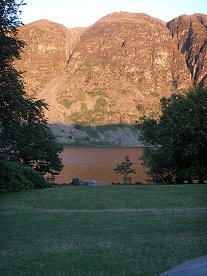
Wasdale
Wasdale is a valley and civil parish in the western part of the Lake District National Park in Cumbria, England. The River Irt flows through the valley to its estuary at Ravenglass. A large part of the main valley floor is occupied by Wastwater, the deepest lake in England...
or Eskdale Green in Eskdale
Eskdale, Cumbria
Eskdale is a glacial valley and civil parish in the western Lake District National Park in Cumbria, England. It forms part of the Borough of Copeland, and has a population of 264....
using the bridleway which links the two places to attain the western ridge of the fell, there are then 230 metres of ascent up the ridge to reach the summit. Walkers starting from the Wasdale side can also use the footpath by Greathall Gill as already mentioned.
View
The highlight of the summit panorama is obviously the view down to Wast Water, however the Sellafield Nuclear PlantSellafield
Sellafield is a nuclear reprocessing site, close to the village of Seascale on the coast of the Irish Sea in Cumbria, England. The site is served by Sellafield railway station. Sellafield is an off-shoot from the original nuclear reactor site at Windscale which is currently undergoing...
is well seen to the west as are the well known fells around the head of Wasdale.