
Illgill Head
Encyclopedia
Illgill Head is a fell
in the English Lake District. It is known more commonly as the northern portion of the Wastwater Screes. The fell is 609 metres high and stands along the south-east shore of Wast Water
, the deepest lake in England.
. Poet Norman Nicholson
described the Screes as "like the inverted arches of a Gothic Cathedral".
The title Wastwater Screes applies to the scree
-covered north-western fellside which plunges dramatically down into Wast Water. This also includes Illgill Head's neighbour Whin Rigg
, the continuation of the ridge to the south-west. The scree slope continues beneath the lake to a depth of 79 metres. The screes were formed as a result of ice and weathering erosion on the rocks. Geologically, Illgill Head and Whin Rigg are part of the Borrowdale Volcanic Group, typical for the southern-western area of the Lake District.
In marked contrast to the north-western slope, the opposite flank of the fell, which descends to Burnmoor Tarn and Miterdale is much gentler and covered in heather and bracken.
, lapilli
-tuff and breccia
of the Lingmell Formation amid the drift deposits. The crags atop the screes reveal the plagioclase
-phyric andesite
lava
s of the Birker Fell Formation.
the grassy plateau gradually tilts, until a few yards away it simply disappears over the brink. Illgill Head is a fine viewpoint for Wasdale Head, the surrounding fells all appearing as they soar up from the dalehead. Nearer views, with care, are possible down the Screes themselves.
over the north-eastern shoulder of the fell, skirting the edge of the Screes. There is also an ascent from Boot in Eskdale
either over Whin Rigg or direct via Burnmoor Tarn.
A lakeside path along the south-eastern shore of Wast Water starts at Wasdale Head Hall and continues through the boulder field with exhilarating close-up views of the Screes.
Fell
“Fell” is a word used to refer to mountains, or certain types of mountainous landscape, in Scandinavia, the Isle of Man, and parts of northern England.- Etymology :...
in the English Lake District. It is known more commonly as the northern portion of the Wastwater Screes. The fell is 609 metres high and stands along the south-east shore of Wast Water
Wast Water
Wast Water or Wastwater is a lake located in Wasdale, a valley in the western part of the Lake District National Park, England. The lake is approximately 4.6 kilometres long and 600 metres wide. It is the deepest lake in England at 79 metres , and is owned by the National Trust...
, the deepest lake in England.
Topography
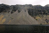
The panorama of the Wastwater Screes across Wast Water is one of the most famous and awe-inspiring views in EnglandEngland
England is a country that is part of the United Kingdom. It shares land borders with Scotland to the north and Wales to the west; the Irish Sea is to the north west, the Celtic Sea to the south west, with the North Sea to the east and the English Channel to the south separating it from continental...
. Poet Norman Nicholson
Norman Nicholson
Norman Cornthwaite Nicholson OBE, , was an English poet, known for his association with the Cumberland town of Millom...
described the Screes as "like the inverted arches of a Gothic Cathedral".
The title Wastwater Screes applies to the scree
Scree
Scree, also called talus, is a term given to an accumulation of broken rock fragments at the base of crags, mountain cliffs, or valley shoulders. Landforms associated with these materials are sometimes called scree slopes or talus piles...
-covered north-western fellside which plunges dramatically down into Wast Water. This also includes Illgill Head's neighbour Whin Rigg
Whin Rigg
Whin Rigg is a fell is the English Lake District, situated in the western segment of the national park, 22 kilometres south east of the town of Whitehaven...
, the continuation of the ridge to the south-west. The scree slope continues beneath the lake to a depth of 79 metres. The screes were formed as a result of ice and weathering erosion on the rocks. Geologically, Illgill Head and Whin Rigg are part of the Borrowdale Volcanic Group, typical for the southern-western area of the Lake District.
In marked contrast to the north-western slope, the opposite flank of the fell, which descends to Burnmoor Tarn and Miterdale is much gentler and covered in heather and bracken.
Geology
The summit area has outcropping tuffTuff
Tuff is a type of rock consisting of consolidated volcanic ash ejected from vents during a volcanic eruption. Tuff is sometimes called tufa, particularly when used as construction material, although tufa also refers to a quite different rock. Rock that contains greater than 50% tuff is considered...
, lapilli
Lapilli
Lapilli is a size classification term for tephra, which is material that falls out of the air during a volcanic eruption or during some meteorite impacts. Lapilli means "little stones" in Latin. They are in some senses similar to ooids or pisoids in calcareous sediments.By definition lapilli range...
-tuff and breccia
Breccia
Breccia is a rock composed of broken fragments of minerals or rock cemented together by a fine-grained matrix, that can be either similar to or different from the composition of the fragments....
of the Lingmell Formation amid the drift deposits. The crags atop the screes reveal the plagioclase
Plagioclase
Plagioclase is an important series of tectosilicate minerals within the feldspar family. Rather than referring to a particular mineral with a specific chemical composition, plagioclase is a solid solution series, more properly known as the plagioclase feldspar series...
-phyric andesite
Andesite
Andesite is an extrusive igneous, volcanic rock, of intermediate composition, with aphanitic to porphyritic texture. In a general sense, it is the intermediate type between basalt and dacite. The mineral assemblage is typically dominated by plagioclase plus pyroxene and/or hornblende. Magnetite,...
lava
Lava
Lava refers both to molten rock expelled by a volcano during an eruption and the resulting rock after solidification and cooling. This molten rock is formed in the interior of some planets, including Earth, and some of their satellites. When first erupted from a volcanic vent, lava is a liquid at...
s of the Birker Fell Formation.
Summit and View
The summit is a flat sheepwalk, giving no clue to the drama of the Screes. North west from the cairnCairn
Cairn is a term used mainly in the English-speaking world for a man-made pile of stones. It comes from the or . Cairns are found all over the world in uplands, on moorland, on mountaintops, near waterways and on sea cliffs, and also in barren desert and tundra areas...
the grassy plateau gradually tilts, until a few yards away it simply disappears over the brink. Illgill Head is a fine viewpoint for Wasdale Head, the surrounding fells all appearing as they soar up from the dalehead. Nearer views, with care, are possible down the Screes themselves.
Walks
Illgill Head is commonly ascended from Wasdale HeadWasdale Head
Wasdale Head is a small agricultural village in the Lake District National Park in Cumbria, England. The village claims to be home of the highest mountain , deepest lake , smallest church and biggest liar in England...
over the north-eastern shoulder of the fell, skirting the edge of the Screes. There is also an ascent from Boot in Eskdale
Eskdale, Cumbria
Eskdale is a glacial valley and civil parish in the western Lake District National Park in Cumbria, England. It forms part of the Borough of Copeland, and has a population of 264....
either over Whin Rigg or direct via Burnmoor Tarn.
A lakeside path along the south-eastern shore of Wast Water starts at Wasdale Head Hall and continues through the boulder field with exhilarating close-up views of the Screes.