
Whatstandwell
Encyclopedia
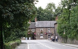
Whatstandwell is a village on the River Derwent
in Derbyshire
, England.
It is about five miles south of Matlock and about four miles north of Belper
. Whatstandwell railway station
is located on the Derby
-Matlock Derwent Valley Line
, and the A6 trunk road
crosses the River Derwent in the village.
On Burdett's Map of 1791 it is shown as "Hottstandell Bridge", probably a literal spelling of the local dialect. A mid nineteenth century Ordnance Survey
map shows it as "Whatstandwell Bridge" which was the name given to the railway station. The name derives from Walter Stonewell, who "held of the convent" the house next to the bridge which John de Strepul built at his own expense, in 1393.
The Cromford Canal
also passes through the village, which was an important transport route to and from Arkwright's
Mill in the nineteenth century. The Friends Of Cromford Canal are currently seeking to reopen this navigation in full from Cromford to its junction with the Erewash Canal
at Langley Mill
. This area is part of the Derwent Valley Mills
Heritage Site
.
Whatstandwell is notable in that the road, canal, railway and river run parallel to each other for some distance up the narrow valley.
To the east of the village is the steep climb to Crich
and the National Tramway Museum
, while a short distance to the north is the former rope-worked incline of the Cromford and High Peak Railway
. To the south, on the west bank of the Derwent
, lie Shining Cliff Woods
, which are a National Trust
property — however there is no official access to this end of the woods.
The village has an active social group that holds several village events each year. Currently the flagship of these is the village 'Beer Festival' held on one of the first two weekends in July. This features local bands, a performance from the village primary school's harmony group, games and a BBQ. The social group also organise a pantomime, horticultural show, children's Halloween party, bonfire night, carol concert and publish a quarterly newsletter. Unfortunately the once annual raft race was abandoned due to lack of support and access issues.
Ellen MacArthur
, the round-the-world sailor, grew up in Whatstandwell.
Whatstandwell is mentioned in the D H Lawrence novel Sons and Lovers
, published 1913, in a scene in which Paul Morel and Miriam go on a day's outing: "They went on, miles and miles, to Whatstandwell. All the food was eaten, everybody was hungry, and there was very little money to get home with. But they managed to procure a loaf and a currant-loaf, which they hacked to pieces with shut-knives, and ate sitting on the wall near the bridge, watching the bright Derwent rushing by, and the brakes from Matlock pulling up at the inn."
River Derwent, Derbyshire
The Derwent is a river in the county of Derbyshire, England. It is 66 miles long and is a tributary of the River Trent which it joins south of Derby. For half its course, the river flows through the Peak District....
in Derbyshire
Derbyshire
Derbyshire is a county in the East Midlands of England. A substantial portion of the Peak District National Park lies within Derbyshire. The northern part of Derbyshire overlaps with the Pennines, a famous chain of hills and mountains. The county contains within its boundary of approx...
, England.
It is about five miles south of Matlock and about four miles north of Belper
Belper
Belper is a town and civil parish in the local government district of Amber Valley in Derbyshire, England.-Geography:Belper is situated eight miles north of Derby and is centred in the valley of the River Derwent...
. Whatstandwell railway station
Whatstandwell railway station
Whatstandwell railway station is a railway station owned by Network Rail and managed by East Midlands Trains Train operating company . It serves the villages of Whatstandwell and Crich Carr in Derbyshire, England...
is located on the Derby
Derby
Derby , is a city and unitary authority in the East Midlands region of England. It lies upon the banks of the River Derwent and is located in the south of the ceremonial county of Derbyshire. In the 2001 census, the population of the city was 233,700, whilst that of the Derby Urban Area was 229,407...
-Matlock Derwent Valley Line
Derwent Valley Line
The Derwent Valley Line is a railway line from Derby to Matlock in Derbyshire.The line follows the Midland Main Line as far as Ambergate Junction, which is just south of Ambergate railway station, continuing to Matlock, following the course of the River Derwent.*Derby*Duffield**Former branch line...
, and the A6 trunk road
Trunk road
A trunk road, trunk highway, or strategic road is a major road—usually connecting two or more cities, ports, airports, and other things.—which is the recommended route for long-distance and freight traffic...
crosses the River Derwent in the village.
On Burdett's Map of 1791 it is shown as "Hottstandell Bridge", probably a literal spelling of the local dialect. A mid nineteenth century Ordnance Survey
Ordnance Survey
Ordnance Survey , an executive agency and non-ministerial government department of the Government of the United Kingdom, is the national mapping agency for Great Britain, producing maps of Great Britain , and one of the world's largest producers of maps.The name reflects its creation together with...
map shows it as "Whatstandwell Bridge" which was the name given to the railway station. The name derives from Walter Stonewell, who "held of the convent" the house next to the bridge which John de Strepul built at his own expense, in 1393.
The Cromford Canal
Cromford Canal
The Cromford Canal ran 14.5 miles from Cromford to the Erewash Canal in Derbyshire, England with a branch to Pinxton. Built by William Jessop with the assistance of Benjamin Outram, its alignment included four tunnels and 14 locks....
also passes through the village, which was an important transport route to and from Arkwright's
Richard Arkwright
Sir Richard Arkwright , was an Englishman who, although the patents were eventually overturned, is often credited for inventing the spinning frame — later renamed the water frame following the transition to water power. He also patented a carding engine that could convert raw cotton into yarn...
Mill in the nineteenth century. The Friends Of Cromford Canal are currently seeking to reopen this navigation in full from Cromford to its junction with the Erewash Canal
Erewash Canal
The Erewash Canal is a broad canal in Derbyshire, England. It runs just under and has 14 locks. The first lock at Langley Bridge is actually part of the Cromford Canal.-Origins:...
at Langley Mill
Langley Mill
Langley Mill is a small town in the Amber Valley district of Derbyshire, England. It is on the border of Nottinghamshire, and runs into the towns of Aldercar and Heanor . Across the River Erewash is the Nottinghamshire town of Eastwood. It is part of the Aldercar and Langley Mill parish....
. This area is part of the Derwent Valley Mills
Derwent Valley Mills
Derwent Valley Mills is a World Heritage Site along the River Derwent in Derbyshire, England, designated in December 2001. It is administered by the Derwent Valley Mills Partnership. The modern factory, or 'mill', system was born here in the 18th century to accommodate the new technology for...
Heritage Site
World Heritage Site
A UNESCO World Heritage Site is a place that is listed by the UNESCO as of special cultural or physical significance...
.
Whatstandwell is notable in that the road, canal, railway and river run parallel to each other for some distance up the narrow valley.
To the east of the village is the steep climb to Crich
Crich
Crich is a village in Derbyshire in England. It has the National Tramway Museum inside the Crich Tramway Village, and at the summit of Crich Hill above, a Memorial Tower for those of the Sherwood Foresters regiment who died in battle, particularly in World War I.Built in 1923 on the site of an...
and the National Tramway Museum
National Tramway Museum
The National Tramway Museum, at Crich, in Derbyshire, England, is situated within Crich Tramway Village, a period village containing a pub, cafe, old-style sweetshop, including the tram depots. The village is also home to the Eagle Press, a small museum dedicated to Letterpress Printing including...
, while a short distance to the north is the former rope-worked incline of the Cromford and High Peak Railway
Cromford and High Peak Railway
The Cromford and High Peak Railway in Derbyshire, England, was completed in 1831, to carry minerals and goods between the Cromford Canal wharf at High Peak Junction and the Peak Forest Canal at Whaley Bridge -Origins:...
. To the south, on the west bank of the Derwent
River Derwent, Derbyshire
The Derwent is a river in the county of Derbyshire, England. It is 66 miles long and is a tributary of the River Trent which it joins south of Derby. For half its course, the river flows through the Peak District....
, lie Shining Cliff Woods
Shining Cliff Woods, Derbyshire
Shining Cliff Woods are on the west bank of the River Derwent near to Ambergate Derbyshire.In medieval times "Schymynde-cliffe" was one of the seven royal parks within Duffield Frith and, as such, belonged to Edmund Crouchback, Earl of Lancaster...
, which are a National Trust
National Trust for Places of Historic Interest or Natural Beauty
The National Trust for Places of Historic Interest or Natural Beauty, usually known as the National Trust, is a conservation organisation in England, Wales and Northern Ireland...
property — however there is no official access to this end of the woods.
The village has an active social group that holds several village events each year. Currently the flagship of these is the village 'Beer Festival' held on one of the first two weekends in July. This features local bands, a performance from the village primary school's harmony group, games and a BBQ. The social group also organise a pantomime, horticultural show, children's Halloween party, bonfire night, carol concert and publish a quarterly newsletter. Unfortunately the once annual raft race was abandoned due to lack of support and access issues.
Ellen MacArthur
Ellen MacArthur
Dame Ellen Patricia MacArthur, DBE is an English sailor, up until 2009, from Whatstandwell near Matlock in Derbyshire, now based in West Cowes, on the Isle of Wight. She is best known as a solo long-distance yachtswoman. On 7 February 2005 she broke the world record for the fastest solo...
, the round-the-world sailor, grew up in Whatstandwell.
Whatstandwell is mentioned in the D H Lawrence novel Sons and Lovers
Sons and Lovers
Sons and Lovers is a 1913 novel by the English writer D. H. Lawrence. The Modern Library placed it ninth on their list of the 100 best novels of the 20th century.-Plot introduction and history:...
, published 1913, in a scene in which Paul Morel and Miriam go on a day's outing: "They went on, miles and miles, to Whatstandwell. All the food was eaten, everybody was hungry, and there was very little money to get home with. But they managed to procure a loaf and a currant-loaf, which they hacked to pieces with shut-knives, and ate sitting on the wall near the bridge, watching the bright Derwent rushing by, and the brakes from Matlock pulling up at the inn."