
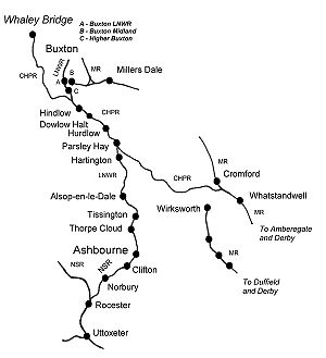
Cromford and High Peak Railway
Encyclopedia
The Cromford and High Peak Railway (C&HPR) in Derbyshire
, England
, was completed in 1831, to carry mineral
s and goods between the Cromford Canal
wharf at High Peak Junction
and the Peak Forest Canal
at Whaley Bridge
of Derbyshire
has always posed problems for travel, but from 1800 when the Peak Forest Canal was built, an alternative to the long route through the Trent and Mersey Canal
was sought, not only for minerals and finished goods to Manchester
, but raw cotton
for the East Midlands
textile
industry.
One scheme that had been suggested would pass via Tansley
, Matlock and Bakewell
. In 1810, a prospectus was published for another route via Grindleford
, Hope
and Edale
, but since it could only promise £6,000 a year, in return for an outlay of £500,000, it was received with little enthusiasm. The problem was not only carrying a canal over a height of around a thousand feet, but supplying it with water on the dry limestone
uplands.
Finally Josias Jessop
, the son of William Jessop
was asked to survey the route. He, his father and their former partner Benjamin Outram
had gained wide experience in building tramways where conditions were unsuitable for canals, and that is what he suggested. Even so, as almost the first long distance line at thirty three miles, it was a bold venture. Moreover, to its summit at Ladmanlow, it would climb a thousand feet from Cromford, making it one of the highest lines ever built in Britain
.
In 1825 the Act of Parliament was obtained for a "railway or tramroad" to be propelled by "stationary or locomotive steam engines," which was remarkably prescient, considering few people considered steam locomotives to be feasible, and George Stephenson
's Stockton and Darlington Railway
was barely open in far-away County Durham.
 The first part of the line from the wharf at High Peak Junction, on the Cromford Canal, to Hurdlow opened in 1830. From the canal it climbed over a thousand feet in five miles, through four inclines ranging from 1 in 14 to 1 in 8 - Cromford, Sheep Pasture, Middleton and Hopton, above Wirksworth
. The line then proceeded up the relatively gentle Hurdlow incline at 1 in 16 . The second half from Hurdlow to Whaley Bridge opened in 1832 descending through four more inclines, the steepest being 1 in 7. The highest part of the line was at Ladmanlow, a height of 1266 feet (386 m). For comparison, the present day highest summit in England is Ais Gill at 1169 feet (356 m) on the Settle-Carlisle line
.
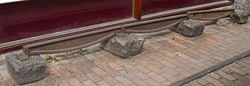
The railway was laid using so-called "fishbelly" rails supported on stone blocks, as was common in those days, rather than timber sleepers, since it would be powered by horse
s on the flat sections. On the nine inclined planes, stationary steam engine
s would be used, apart from the last incline into Whaley Bridge, which was counterbalanced and worked by a horse-gin
. The engines, rails and other ironwork were provided by the Butterley Company
. It would take around two days to complete the journey. Luckily it was laid to the Stephenson gauge of 4 ft 8½ inch, rather than Outram's usual 4 ft 2 in.
While its function was to provide a shorter route for Derbyshire coal than the Trent and Mersey Canal
, it figured largely in early East Midlands railway schemes because it was seen as offering a path into Manchester for proposed lines from London. However, the unsuitability of cable railways for passengers became clear within a few years.
The following table lists the inclines as originally built :
 Across the plateau, since the line had been built on the canal principle of following contours, there were many tight curves, which in later years, were to hamper operations. Not only did the C&HPR have the steepest adhesion worked
incline of any line in the country, the 1 in 14 of Hopton, it also had the sharpest curve, 55 yards (50 m) radius through eighty degrees at Gotham.
The line was isolated until 1853 when, in an effort to improve traffic, a connection was made with the Manchester, Buxton, Matlock and Midlands Junction Railway
at High Peak Junction just north of Whatstandwell
. In 1857 the northern end was connected to the Stockport, Disley and Whaley Bridge Railway
. Around this time, the people of Wirksworth
were agitating for a line and an incline was built between the two. However, the Midland Railway
began surveying a line from Duffield in 1862 and it was never used.
The C&HPR was leased by the London and North Western Railway
in 1862, being taken over fully in 1887. By 1890 permission had been obtained to connect the line directly to Buxton
by building a new line from Harpur Hill the two or three miles into the town centre, thus frustrating the Midland Railway
's plans for a route to Manchester.
The old north end of the line from Ladmanlow (a short distance from Harpur Hill) to Whaley Bridge
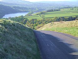
via the Goyt Valley was largely abandoned in 1892, though the track bed is still visible in many places and one incline forms part of a public road.
Then, built by the LNWR, the branch line to Ashbourne
was opened in 1899. This utilized the section of the C&HP line from Buxton as far as Parsley Hay, from where a single line ran south to Ashbourne, where it connected with the North Staffordshire Railway
. The formation was constructed to allow for double tracking if necessary, but this never happened
The railway's first steam locomotive arrived in 1841 in the shape of Peak, built by Robert Stephenson and Company
. By 1860 the line had six more locomotives gradually displacing the horses. Because the inclines were too steep for adhesion traction by these early locomotives, they were hauled up and down the inclines, along with their trains, by static steam engines. Hemp rope or chain, initially used for hauling trains, was later replaced by steel cables.
In 1855 an Act of Parliament authorised the carriage of passengers. However the one train per day each ways did little to produce extra revenue and, when a passenger was killed in 1877, the service was discontinued. The line's prosperity depended on that of the canals it connected but, by the 1830s, they were in decline. This was, to a degree, offset by the increase in the trade for limestone from the quarries.
There were, in fact, very few accidents. In 1857, the Cromford and Sheep Pasture inclines had been merged into one, and in 1888, a brake van parted from the train near the summit. Gathering speed, it was unable to round the curve into Cromford Wharf. It passed over both the canal and the double track railway line, and landed in a field. A catch pit was therefore installed near the bottom. This can still be seen from the A6 with a (more recent) wrecked wagon still in it.
The most serious accident occurred in 1937. The line was fairly level on the approach to the Hopton Incline and it was the custom to gain speed for the uphill gradient. There was a shallow curve immediately before and on this occasion the locomotive spread the track, rolled over and down the embankment with four wagons. The driver was killed and thereafter a speed limit of 40 mph was strictly enforced.
there were over 15 sidings, mostly grouped between Sheep Pasture and Longcliffe
, primarily serving quarries. One was built in 1883 from Steeplehouse to serve the Middleton Quarry north of Wirksworth. The branch closed in 1967 but the trackbed was later used for the Steeple Grange Light Railway
in 1985.
Towards the Whaley Bridge end of the line, another plethora of sidings lay between Dowlow Halt and Ladmanlow, mostly serving quarries and limeworks. This included some dozen sidings which lay in the short section between Harpur Hill and Old Harpur.
, the first section of the line being closed in 1963. This was the rope worked 1 in 8 Middleton Incline. The rest of the line was fully closed in spring 1967, including the 1 in 8 Sheep Pasture Incline and the Hopton Incline
.
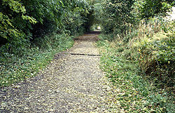
In 1971 the Peak Park Planning Board and Derbyshire County Council bought part of the track bed (i.e. from Dowlow, near Buxton, to High Peak Junction, Cromford) and turned it into the High Peak Trail - now a national route of the National Cycle Network
and popular with walkers
, cyclists
and horse riders.
The High Peak Trail (and indeed part of the Tissington Trail, below) are now also designated as part of the Pennine Bridleway
, a leisure route which starts at Middleton Top, near Cromford, and includes 73 miles (117 km) through Derbyshire to the South Pennines.
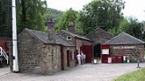
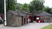
The Middleton Incline Engine House has also been preserved, and the ancient engine once used to haul loaded wagons up is often demonstrated http://www.grant2222.freeserve.co.uk/mtlhp.htm. Another attraction along the route is the Steeple Grange Light Railway
, a narrow gauge railway running along the track bed of a branch line off the C&HPR.
Near Cromford at the top of the town of Wirksworth, the railway passed under Black Rocks a popular gritstone
climbing ground, and gave the name to the 'railway slab', a short tricky 'boulder problem'
by the railway track.
At the hamlet of Parsley Hay, about 5 miles (8 km) SW of Bakewell, the C&HPR/High Peak Trail is joined by the Tissington Trail
, another route of the National Cycle Network, and formerly the railway line from Buxton to Ashbourne. This 13 miles (21 km) recreational route runs from Parsley Hay to Ashbourne on a gently descending gradient.
Derbyshire
Derbyshire is a county in the East Midlands of England. A substantial portion of the Peak District National Park lies within Derbyshire. The northern part of Derbyshire overlaps with the Pennines, a famous chain of hills and mountains. The county contains within its boundary of approx...
, England
England
England is a country that is part of the United Kingdom. It shares land borders with Scotland to the north and Wales to the west; the Irish Sea is to the north west, the Celtic Sea to the south west, with the North Sea to the east and the English Channel to the south separating it from continental...
, was completed in 1831, to carry mineral
Mineral
A mineral is a naturally occurring solid chemical substance formed through biogeochemical processes, having characteristic chemical composition, highly ordered atomic structure, and specific physical properties. By comparison, a rock is an aggregate of minerals and/or mineraloids and does not...
s and goods between the Cromford Canal
Cromford Canal
The Cromford Canal ran 14.5 miles from Cromford to the Erewash Canal in Derbyshire, England with a branch to Pinxton. Built by William Jessop with the assistance of Benjamin Outram, its alignment included four tunnels and 14 locks....
wharf at High Peak Junction
High Peak Junction
High Peak Junction, near Cromford, Derbyshire, England, is the name now used to describe the site where the former Cromford and High Peak Railway , whose workshops were located here, meets the Cromford Canal...
and the Peak Forest Canal
Peak Forest Canal
The Peak Forest Canal, is a narrow locked artificial waterway in northern England. It is long and forms part of the connected English/Welsh inland waterway network.-General description:...
at Whaley Bridge
Whaley Bridge
Whaley Bridge is a small town and civil parish in the High Peak district of Derbyshire, England, situated on the River Goyt. Whaley Bridge is approximately south of Manchester, north of Buxton , east of Macclesfield and west of Sheffield, and had a population of 6,226 at the 2001 census. This...
Origins
The Peak DistrictPeak District
The Peak District is an upland area in central and northern England, lying mainly in northern Derbyshire, but also covering parts of Cheshire, Greater Manchester, Staffordshire, and South and West Yorkshire....
of Derbyshire
Derbyshire
Derbyshire is a county in the East Midlands of England. A substantial portion of the Peak District National Park lies within Derbyshire. The northern part of Derbyshire overlaps with the Pennines, a famous chain of hills and mountains. The county contains within its boundary of approx...
has always posed problems for travel, but from 1800 when the Peak Forest Canal was built, an alternative to the long route through the Trent and Mersey Canal
Trent and Mersey Canal
The Trent and Mersey Canal is a in the East Midlands, West Midlands, and North West of England. It is a "narrow canal" for the vast majority of its length, but at the extremities—east of Burton upon Trent and west of Middlewich—it is a wide canal....
was sought, not only for minerals and finished goods to Manchester
Manchester
Manchester is a city and metropolitan borough in Greater Manchester, England. According to the Office for National Statistics, the 2010 mid-year population estimate for Manchester was 498,800. Manchester lies within one of the UK's largest metropolitan areas, the metropolitan county of Greater...
, but raw cotton
Cotton
Cotton is a soft, fluffy staple fiber that grows in a boll, or protective capsule, around the seeds of cotton plants of the genus Gossypium. The fiber is almost pure cellulose. The botanical purpose of cotton fiber is to aid in seed dispersal....
for the East Midlands
East Midlands
The East Midlands is one of the regions of England, consisting of most of the eastern half of the traditional region of the Midlands. It encompasses the combined area of Nottinghamshire, Derbyshire, Leicestershire, Rutland, Northamptonshire and most of Lincolnshire...
textile
Textile
A textile or cloth is a flexible woven material consisting of a network of natural or artificial fibres often referred to as thread or yarn. Yarn is produced by spinning raw fibres of wool, flax, cotton, or other material to produce long strands...
industry.
One scheme that had been suggested would pass via Tansley
Tansley
Tansley is a village on the southern edge of the Derbyshire Peak District, two miles east of Matlock.-History:Tansley is recorded in the Domesday Book as Tanslege, and its name comes from the combination of the Old English words lega, meaning "wood or glade" and tan meaning "a branch of a...
, Matlock and Bakewell
Bakewell
Bakewell is a small market town in the Derbyshire Dales district of Derbyshire, England, deriving its name from 'Beadeca's Well'. It is the only town included in the Peak District National Park, and is well known for the local confection Bakewell Pudding...
. In 1810, a prospectus was published for another route via Grindleford
Grindleford
Grindleford is a village and parish in the county of Derbyshire, in the East Midlands of England. It lies at an altitude of in the valley of the River Derwent in the Peak District National Park. On the west side of the valley is the high Sir William Hill, and to the south-east lies the gritstone...
, Hope
Hope, Derbyshire
Hope is a village in the Derbyshire Peak District, in England. It lies in the Hope Valley, at the point where Peakshole Water flows into the River Noe. To the north, Win Hill and Lose Hill stand either side of the Noe....
and Edale
Edale
Edale is a small Derbyshire village and Civil parish in the Peak District, in the Midlands of England. The Parish of Edale,area ,is in the Borough of High Peak....
, but since it could only promise £6,000 a year, in return for an outlay of £500,000, it was received with little enthusiasm. The problem was not only carrying a canal over a height of around a thousand feet, but supplying it with water on the dry limestone
Limestone
Limestone is a sedimentary rock composed largely of the minerals calcite and aragonite, which are different crystal forms of calcium carbonate . Many limestones are composed from skeletal fragments of marine organisms such as coral or foraminifera....
uplands.
Finally Josias Jessop
Josias Jessop
Josias Jessop was a noted canal engineer, and second son of William Jessop.In 1802 he and his father were appointed engineers of the proposed Croydon, Merstham and Godstone Railway....
, the son of William Jessop
William Jessop
William Jessop was an English civil engineer, best known for his work on canals, harbours and early railways in the late 18th and early 19th centuries.-Early life:...
was asked to survey the route. He, his father and their former partner Benjamin Outram
Benjamin Outram
Benjamin Outram was an English civil engineer, surveyor and industrialist. He was a pioneer in the building of canals and tramways.-Personal life:...
had gained wide experience in building tramways where conditions were unsuitable for canals, and that is what he suggested. Even so, as almost the first long distance line at thirty three miles, it was a bold venture. Moreover, to its summit at Ladmanlow, it would climb a thousand feet from Cromford, making it one of the highest lines ever built in Britain
United Kingdom
The United Kingdom of Great Britain and Northern IrelandIn the United Kingdom and Dependencies, other languages have been officially recognised as legitimate autochthonous languages under the European Charter for Regional or Minority Languages...
.
In 1825 the Act of Parliament was obtained for a "railway or tramroad" to be propelled by "stationary or locomotive steam engines," which was remarkably prescient, considering few people considered steam locomotives to be feasible, and George Stephenson
George Stephenson
George Stephenson was an English civil engineer and mechanical engineer who built the first public railway line in the world to use steam locomotives...
's Stockton and Darlington Railway
Stockton and Darlington Railway
The Stockton and Darlington Railway , which opened in 1825, was the world's first publicly subscribed passenger railway. It was 26 miles long, and was built in north-eastern England between Witton Park and Stockton-on-Tees via Darlington, and connected to several collieries near Shildon...
was barely open in far-away County Durham.
Construction
Wirksworth
Wirksworth is a small market town in Derbyshire, England, with a population of over 9,000.The population of the Wirksworth area including Cromford, Bolehill and Middleton-by-Wirksworth is about 12,000. Wirksworth is listed in the Domesday Book in 1086. Within it is the source of the River...
. The line then proceeded up the relatively gentle Hurdlow incline at 1 in 16 . The second half from Hurdlow to Whaley Bridge opened in 1832 descending through four more inclines, the steepest being 1 in 7. The highest part of the line was at Ladmanlow, a height of 1266 feet (386 m). For comparison, the present day highest summit in England is Ais Gill at 1169 feet (356 m) on the Settle-Carlisle line
Settle-Carlisle Railway
The Settle–Carlisle Line is a long main railway line in northern England. It is also known as the Settle and Carlisle. It is a part of the National Rail network and was constructed in the 1870s...
.
The railway was laid using so-called "fishbelly" rails supported on stone blocks, as was common in those days, rather than timber sleepers, since it would be powered by horse
Horse
The horse is one of two extant subspecies of Equus ferus, or the wild horse. It is a single-hooved mammal belonging to the taxonomic family Equidae. The horse has evolved over the past 45 to 55 million years from a small multi-toed creature into the large, single-toed animal of today...
s on the flat sections. On the nine inclined planes, stationary steam engine
Stationary steam engine
Stationary steam engines are fixed steam engines used for pumping or driving mills and factories, and for power generation. They are distinct from locomotive engines used on railways, traction engines for heavy steam haulage on roads, steam cars , agricultural engines used for ploughing or...
s would be used, apart from the last incline into Whaley Bridge, which was counterbalanced and worked by a horse-gin
Horse mill
A horse mill is a mill that uses a horse as the power source. Any milling process can be powered in this way, but the most frequent use of animal power in horse mills was for grinding grain and pumping water. Other animals used for powering mills include dogs, donkeys and oxen. Engines powered by...
. The engines, rails and other ironwork were provided by the Butterley Company
Butterley Company
Butterley Engineering was an engineering company based in Ripley, Derbyshire. The company was formed from the Butterley Company which began as Benjamin Outram and Company in 1790 and existed until 2009.-Origins:...
. It would take around two days to complete the journey. Luckily it was laid to the Stephenson gauge of 4 ft 8½ inch, rather than Outram's usual 4 ft 2 in.
While its function was to provide a shorter route for Derbyshire coal than the Trent and Mersey Canal
Trent and Mersey Canal
The Trent and Mersey Canal is a in the East Midlands, West Midlands, and North West of England. It is a "narrow canal" for the vast majority of its length, but at the extremities—east of Burton upon Trent and west of Middlewich—it is a wide canal....
, it figured largely in early East Midlands railway schemes because it was seen as offering a path into Manchester for proposed lines from London. However, the unsuitability of cable railways for passengers became clear within a few years.
The following table lists the inclines as originally built :
| Incline | Length | Gradient | Notes |
|---|---|---|---|
| Cromford | 580 yards (530 m) | 1 in 9 | combined with Sheep Pasture in 1857 |
| Sheep Pasture | 711 yards (650 m) | 1 in 8 | this name retained after combining with Cromford in 1857 |
| Middleton | 708 yards (647 m) | 1 in 8½ | |
| Hopton | 457 yards (418 m) | 1 in 14 | |
| Hurdlow | 850 yards (777 m) | 1 in 16 | abandoned 1869 |
| Bunsall upper | 660 yards (604 m) | 1 in 17½ | combined with Bunsall lower in 1857, abandoned 1892 |
| Bunsall lower | 455 yards (416 m) | 1 in 7 | combined with Bunsall upper in 1857, abandoned 1892 |
| Shallcross | 817 yards (747 m) | 1 in 10¼ | abandoned 1892 |
| Whaley Bridge | 180 yards (165 m) | 1 in 13½ | abandoned 1952 |
Expansion
Rail adhesion
The term adhesion railway or adhesion traction describes the most common type of railway, where power is applied by driving some or all of the wheels of the locomotive. Thus, it relies on the friction between a steel wheel and a steel rail. Note that steam locomotives of old were driven only by...
incline of any line in the country, the 1 in 14 of Hopton, it also had the sharpest curve, 55 yards (50 m) radius through eighty degrees at Gotham.
The line was isolated until 1853 when, in an effort to improve traffic, a connection was made with the Manchester, Buxton, Matlock and Midlands Junction Railway
Manchester, Buxton, Matlock and Midlands Junction Railway
The Manchester, Buxton, Matlock and Midland Junction Railway ran from a junction with the Midland Railway at Ambergate to Rowsley north of Matlock and thence to Buxton....
at High Peak Junction just north of Whatstandwell
Whatstandwell
Whatstandwell is a village on the River Derwent in Derbyshire, England.It is about five miles south of Matlock and about four miles north of Belper...
. In 1857 the northern end was connected to the Stockport, Disley and Whaley Bridge Railway
Stockport, Disley and Whaley Bridge Railway
The Stockport, Disley and Whaley Bridge Railway was an early railway company in England which was opened in 1857 between Stockport Edgeley and Whaley Bridge.- Origins :...
. Around this time, the people of Wirksworth
Wirksworth
Wirksworth is a small market town in Derbyshire, England, with a population of over 9,000.The population of the Wirksworth area including Cromford, Bolehill and Middleton-by-Wirksworth is about 12,000. Wirksworth is listed in the Domesday Book in 1086. Within it is the source of the River...
were agitating for a line and an incline was built between the two. However, the Midland Railway
Midland Railway
The Midland Railway was a railway company in the United Kingdom from 1844 to 1922, when it became part of the London, Midland and Scottish Railway....
began surveying a line from Duffield in 1862 and it was never used.
The C&HPR was leased by the London and North Western Railway
London and North Western Railway
The London and North Western Railway was a British railway company between 1846 and 1922. It was created by the merger of three companies – the Grand Junction Railway, the London and Birmingham Railway and the Manchester and Birmingham Railway...
in 1862, being taken over fully in 1887. By 1890 permission had been obtained to connect the line directly to Buxton
Buxton
Buxton is a spa town in Derbyshire, England. It has the highest elevation of any market town in England. Located close to the county boundary with Cheshire to the west and Staffordshire to the south, Buxton is described as "the gateway to the Peak District National Park"...
by building a new line from Harpur Hill the two or three miles into the town centre, thus frustrating the Midland Railway
Midland Railway
The Midland Railway was a railway company in the United Kingdom from 1844 to 1922, when it became part of the London, Midland and Scottish Railway....
's plans for a route to Manchester.
The old north end of the line from Ladmanlow (a short distance from Harpur Hill) to Whaley Bridge
Whaley Bridge
Whaley Bridge is a small town and civil parish in the High Peak district of Derbyshire, England, situated on the River Goyt. Whaley Bridge is approximately south of Manchester, north of Buxton , east of Macclesfield and west of Sheffield, and had a population of 6,226 at the 2001 census. This...
via the Goyt Valley was largely abandoned in 1892, though the track bed is still visible in many places and one incline forms part of a public road.
Then, built by the LNWR, the branch line to Ashbourne
Ashbourne Line
The Ashbourne Line was a railway from Buxton via Ashbourne to Uttoxeter. It was built by the London and North Western Railway using a section of the Cromford and High Peak Railway and it joined the North Staffordshire Railway at Ashbourne, proceeding to Uttoxeter with a junction onto the main...
was opened in 1899. This utilized the section of the C&HP line from Buxton as far as Parsley Hay, from where a single line ran south to Ashbourne, where it connected with the North Staffordshire Railway
North Staffordshire Railway
The North Staffordshire Railway was a British railway company formed in 1845 to promote a number of lines in the Staffordshire Potteries and surrounding areas in Staffordshire, Cheshire, Derbyshire and Shropshire....
. The formation was constructed to allow for double tracking if necessary, but this never happened
Operation
The line was worked by independent contractors until long after other lines, which had taken operations in house upon the introduction of locomotives. The line was initially under-capitalised because many of the subscribers did not meet their dues, and it was mainly funded by the Butterley Company which was a major supplier and its main creditor. The final cost was £180,000, more than Jessop's estimate of £155,000, but still much cheaper than a canal. Nevertheless, the line never achieved a profit. Francis Wright, the Chairman was later to say, in 1862 "We found ourselves getting into difficulties from the third year of our existence." and added it was clear in retrospect that the line "never had a remote chance of paying a dividend on the original shares."The railway's first steam locomotive arrived in 1841 in the shape of Peak, built by Robert Stephenson and Company
Robert Stephenson and Company
Robert Stephenson and Company was a locomotive manufacturing company founded in 1823. It was the first company set up specifically to build railway engines.- Foundation and early success :...
. By 1860 the line had six more locomotives gradually displacing the horses. Because the inclines were too steep for adhesion traction by these early locomotives, they were hauled up and down the inclines, along with their trains, by static steam engines. Hemp rope or chain, initially used for hauling trains, was later replaced by steel cables.
In 1855 an Act of Parliament authorised the carriage of passengers. However the one train per day each ways did little to produce extra revenue and, when a passenger was killed in 1877, the service was discontinued. The line's prosperity depended on that of the canals it connected but, by the 1830s, they were in decline. This was, to a degree, offset by the increase in the trade for limestone from the quarries.
There were, in fact, very few accidents. In 1857, the Cromford and Sheep Pasture inclines had been merged into one, and in 1888, a brake van parted from the train near the summit. Gathering speed, it was unable to round the curve into Cromford Wharf. It passed over both the canal and the double track railway line, and landed in a field. A catch pit was therefore installed near the bottom. This can still be seen from the A6 with a (more recent) wrecked wagon still in it.
The most serious accident occurred in 1937. The line was fairly level on the approach to the Hopton Incline and it was the custom to gain speed for the uphill gradient. There was a shallow curve immediately before and on this occasion the locomotive spread the track, rolled over and down the embankment with four wagons. The driver was killed and thereafter a speed limit of 40 mph was strictly enforced.
The many sidings
The railway served dozens of small sidings. Towards the Cromford end of the line, between Sheep Pasture Top and FridenFriden, Derbyshire
Friden is a hamlet in the civil parish of Hartington Nether Quarter, Derbyshire, England. It is located 11 miles south-east of Buxton just off the Newhaven to Cromford Via Gellia road and lies within the Peak District National Park....
there were over 15 sidings, mostly grouped between Sheep Pasture and Longcliffe
Longcliffe
Longcliffe is a crossroads hamlet in the English county of Derbyshire.Longliffe lies on the B5056 road where it is crossed by the Brassington-Elton road. The Midshires Way long-distance footpath skirts the south and west of Longcliffe.- External links :...
, primarily serving quarries. One was built in 1883 from Steeplehouse to serve the Middleton Quarry north of Wirksworth. The branch closed in 1967 but the trackbed was later used for the Steeple Grange Light Railway
Steeple Grange Light Railway
The Steeple Grange Light Railway is a heritage railway at Wirksworth in Derbyshire, UK. It uses industrial locomotives and rolling stock from disused mines, quarries, and steelworks around the country.-The line:...
in 1985.
Towards the Whaley Bridge end of the line, another plethora of sidings lay between Dowlow Halt and Ladmanlow, mostly serving quarries and limeworks. This included some dozen sidings which lay in the short section between Harpur Hill and Old Harpur.
Demise
Traffic - by now almost exclusively from local quarries - was slowly decreasing during the Beeching eraBeeching Axe
The Beeching Axe or the Beeching Cuts are informal names for the British Government's attempt in the 1960s to reduce the cost of running British Railways, the nationalised railway system in the United Kingdom. The name is that of the main author of The Reshaping of British Railways, Dr Richard...
, the first section of the line being closed in 1963. This was the rope worked 1 in 8 Middleton Incline. The rest of the line was fully closed in spring 1967, including the 1 in 8 Sheep Pasture Incline and the Hopton Incline
Hopton Incline
The Hopton Incline was a very steep section of a mineral railway in England worked by adhesion. Its gradient was 1 in 14 .-History:This incline on the Cromford and High Peak Railway was originally worked by a stationary steam engine but was modified later to be adhesion worked by locomotives...
.
The High Peak Trail
main article : High Peak TrailIn 1971 the Peak Park Planning Board and Derbyshire County Council bought part of the track bed (i.e. from Dowlow, near Buxton, to High Peak Junction, Cromford) and turned it into the High Peak Trail - now a national route of the National Cycle Network
National Cycle Network
The National Cycle Network is a network of cycle routes in the United Kingdom.The National Cycle Network was created by the charity Sustrans , and aided by a £42.5 million National Lottery grant. In 2005 it was used for over 230 million trips.Many routes hope to minimise contact with motor...
and popular with walkers
Walking
Walking is one of the main gaits of locomotion among legged animals, and is typically slower than running and other gaits. Walking is defined by an 'inverted pendulum' gait in which the body vaults over the stiff limb or limbs with each step...
, cyclists
Cycling
Cycling, also called bicycling or biking, is the use of bicycles for transport, recreation, or for sport. Persons engaged in cycling are cyclists or bicyclists...
and horse riders.
The High Peak Trail (and indeed part of the Tissington Trail, below) are now also designated as part of the Pennine Bridleway
Pennine Bridleway
The Pennine Bridleway is a new National Trail under designation in Northern England.It runs roughly parallel with the Pennine Way but provides access for horseback riders and cyclists as well as walkers. The trail is around long; through Derbyshire to the South Pennines, the Mary Towneley Loop...
, a leisure route which starts at Middleton Top, near Cromford, and includes 73 miles (117 km) through Derbyshire to the South Pennines.
The Middleton Incline Engine House has also been preserved, and the ancient engine once used to haul loaded wagons up is often demonstrated http://www.grant2222.freeserve.co.uk/mtlhp.htm. Another attraction along the route is the Steeple Grange Light Railway
Steeple Grange Light Railway
The Steeple Grange Light Railway is a heritage railway at Wirksworth in Derbyshire, UK. It uses industrial locomotives and rolling stock from disused mines, quarries, and steelworks around the country.-The line:...
, a narrow gauge railway running along the track bed of a branch line off the C&HPR.
Near Cromford at the top of the town of Wirksworth, the railway passed under Black Rocks a popular gritstone
Gritstone
Gritstone or Grit is a hard, coarse-grained, siliceous sandstone. This term is especially applied to such sandstones that are quarried for building material. British gritstone was used for millstones to mill flour, to grind wood into pulp for paper and for grindstones to sharpen blades. "Grit" is...
climbing ground, and gave the name to the 'railway slab', a short tricky 'boulder problem'
Bouldering
Bouldering is a style of rock climbing undertaken without a rope and normally limited to very short climbs over a crash pad so that a fall will not result in serious injury. It is typically practiced on large natural boulders or artificial boulders in gyms and outdoor urban areas...
by the railway track.
The Tissington Trail
main article : Tissington TrailTissington Trail
right|thumb|200px|The Trail at the site of the former Tissington station, now a picnic site.The Tissington Trail is a bridleway and walk/cycle path in Derbyshire, England...
At the hamlet of Parsley Hay, about 5 miles (8 km) SW of Bakewell, the C&HPR/High Peak Trail is joined by the Tissington Trail
Tissington Trail
right|thumb|200px|The Trail at the site of the former Tissington station, now a picnic site.The Tissington Trail is a bridleway and walk/cycle path in Derbyshire, England...
, another route of the National Cycle Network, and formerly the railway line from Buxton to Ashbourne. This 13 miles (21 km) recreational route runs from Parsley Hay to Ashbourne on a gently descending gradient.