

East Vancouver
Encyclopedia

Vancouver
Vancouver is a coastal seaport city on the mainland of British Columbia, Canada. It is the hub of Greater Vancouver, which, with over 2.3 million residents, is the third most populous metropolitan area in the country,...
, British Columbia
British Columbia
British Columbia is the westernmost of Canada's provinces and is known for its natural beauty, as reflected in its Latin motto, Splendor sine occasu . Its name was chosen by Queen Victoria in 1858...
, Canada
Canada
Canada is a North American country consisting of ten provinces and three territories. Located in the northern part of the continent, it extends from the Atlantic Ocean in the east to the Pacific Ocean in the west, and northward into the Arctic Ocean...
. Geographically, East Vancouver is bordered to the north by Burrard Inlet
Burrard Inlet
Burrard Inlet is a relatively shallow-sided coastal fjord in southwestern British Columbia, Canada. Formed during the last Ice Age, it separates the City of Vancouver and the rest of the low-lying Burrard Peninsula from the slopes of the North Shore Mountains, home to the communities of West...
, to the south by the Fraser River
Fraser River
The Fraser River is the longest river within British Columbia, Canada, rising at Fraser Pass near Mount Robson in the Rocky Mountains and flowing for , into the Strait of Georgia at the city of Vancouver. It is the tenth longest river in Canada...
, and to the east by the city of Burnaby. East Vancouver is divided from Vancouver's "West Side" (not to be confused with the "West End"
West End, Vancouver
The West End of Vancouver, British Columbia, Canada is on the downtown peninsula neighbouring Stanley Park and the areas of Yaletown, Coal Harbour and the downtown financial and central business districts....
of Downtown Vancouver or with West Vancouver) by Ontario Street
Ontario Street (Vancouver)
Ontario Street is the name of an important north-south street bisecting Vancouver, British Columbia, Canada. It runs from 1st Avenue by False Creek in the north, to Kent Avenue alongside the north arm of the Fraser River in the south. It is important because it is the dividing street between...
.
Historically, East Vancouver has been the first home for many non-British immigrants since the 1880s. It was also a more affordable
Affordable housing
Affordable housing is a term used to describe dwelling units whose total housing costs are deemed "affordable" to those that have a median income. Although the term is often applied to rental housing that is within the financial means of those in the lower income ranges of a geographical area, the...
area and traditionally the home for many lower-income working class. The East Side is best summarized by its diversity – in family income, land use, ethnicity and mother tongue. The rapid increase in housing prices and gentrification may be affecting diversity of the area.
History
The region was first settled by aboriginal peoplesAboriginal peoples in Canada
Aboriginal peoples in Canada comprise the First Nations, Inuit and Métis. The descriptors "Indian" and "Eskimo" have fallen into disuse in Canada and are commonly considered pejorative....
sometime around 500 BC. While most aboriginal settlements were in what is now the West Side and downtown areas, one important settlement in what is now East Vancouver was located along the bank of the Fraser River
Fraser River
The Fraser River is the longest river within British Columbia, Canada, rising at Fraser Pass near Mount Robson in the Rocky Mountains and flowing for , into the Strait of Georgia at the city of Vancouver. It is the tenth longest river in Canada...
.
In 1860, the False Creek Trail was built following an old aboriginal path to connect False Creek
False Creek
False Creek is a short inlet in the heart of Vancouver. It separates downtown from the rest of the city. It was named by George Henry Richards during his Hydrographic survey of 1856-63. Science World is located at its eastern end and the Burrard Street Bridge crosses its western end. False Creek is...
with New Westminster. The first permanent European
European ethnic groups
The ethnic groups in Europe are the various ethnic groups that reside in the nations of Europe. European ethnology is the field of anthropology focusing on Europe....
settlement in the area arose in 1865 in what is now Strathcona, Vancouver's first neighbourhood. Even at that time, Strathcona was known simply as the "East End". In the 1880s, the first homes were built in what is now Mount Pleasant.
Construction of North Arm Road (now Fraser Street) began in 1872. This road was constructed to allow farmers to bring their produce to market from the north arm of the Fraser River. Later, in 1890, a railway linked South Vancouver and Mount Pleasant. Besides agriculture, canneries were a major employer for many residents in the 1880s and 1890s.
In 1886, the City of Vancouver was incorporated, and included much of East Vancouver. One exception was the city of South Vancouver, created in 1892, which was an independent municipality until 1929. In 1888, the provincial government designated 65 hectares of land adjacent to modern Hastings Street
Hastings Street (Vancouver)
Hastings Street is one of the most important east-west traffic corridors in the cities of Vancouver and Burnaby, British Columbia, Canada, and used to be a part of the decommissioned Highway 7A...
as a park, now known as Hastings Park
Hastings Park
Hastings Park is located in the northeast sector of Vancouver, British Columbia, Canada in a neighbourhood called Hastings-Sunrise. Its name references Hastings, B.C., also known as New Brighton, which lay at the end of the Douglas Road from New Westminster, founded as a resort and watering-hole...
. Since 1907, the park has been home to the Pacific National Exhibition
Pacific National Exhibition
The Pacific National Exhibition is a non profit organization which hosts an annual 17-day summer fair, seasonal amusement park, and arena in Vancouver, British Columbia, Canada. It usually begins in mid-to-late August, and ends in early September, usually Labour Day.-History:The exhibition has been...
.
The transportation infrastructure expanded through the 1890s. In 1891, four public houses opened along Kingsway
Kingsway (Vancouver)
Kingsway is a major road that crosses through the Canadian cities of Vancouver and Burnaby, British Columbia. Originally called Westminster Road, it was renamed Kingsway in 1913....
to service stagecoaches and carriages. Hourly tramcar service began operating along the old False Creek Trail between Vancouver and New Westminster. This is now paved and was renamed to Kingsway Avenue in 1913. By the 1920s, street car
Tram
A tram is a passenger rail vehicle which runs on tracks along public urban streets and also sometimes on separate rights of way. It may also run between cities and/or towns , and/or partially grade separated even in the cities...
service was installed along the full length of what is now Main Street
Main Street (Vancouver)
Main Street is a major north-south thoroughfare bisecting Vancouver, British Columbia, Canada. It runs from Waterfront Road by Burrard Inlet in the north, to Kent Avenue alongside the north arm of the Fraser River in the south.-Route:...
Development of the area increased during this time. In 1893, a small cedar cottage was built near present day Kingsway
Kingsway (Vancouver)
Kingsway is a major road that crosses through the Canadian cities of Vancouver and Burnaby, British Columbia. Originally called Westminster Road, it was renamed Kingsway in 1913....
and Knight streets. In 1900, the Cedar Cottage Brewery was built near this location and the surrounding area is still known as "Cedar Cottage." A municipal hall was built at East 41st Avenue and Fraser in 1911. Also in 1911, the Hastings Sawmill lands were sold to local working-class people. In the following year, John Oliver High School was built nearby. The Collingwood Free Library also opened in the neighbourhood. This library
Library
In a traditional sense, a library is a large collection of books, and can refer to the place in which the collection is housed. Today, the term can refer to any collection, including digital sources, resources, and services...
was built largely due to donations from a local resident, John Francis Bursill, who wrote for local newspapers under the name "Felix Penne".
Electricity was first provided to South Vancouver in 1914. One of the first street lights in Vancouver was installed at East 48th Avenue and Nanaimo Street. After the First World War
World War I
World War I , which was predominantly called the World War or the Great War from its occurrence until 1939, and the First World War or World War I thereafter, was a major war centred in Europe that began on 28 July 1914 and lasted until 11 November 1918...
a building boom occurred in many areas of East Vancouver, resulting in most of the area being occupied by single-family housing by the 1940s.
A park was established at Trout Lake
Trout Lake (Vancouver)
John Hendry Park is 27 hectare park in the city of Vancouver, British Columbia, Canada. Trout Lake is located in the center of the park and is operated by the Vancouver Parks Board and the Grandview Community Association. The park is often referred to, by the locals, as Trout Lake.- History :The...
in 1926 when Mrs. Aldene Hamber purchased the land and donated it to the city to prevent it from being converted to a municipal dump. A condition of the donation was that the park be named after her father, John Hendry, and maintained by the city.
Additional notable events include:
- 1939 - King George VIGeorge VI of the United KingdomGeorge VI was King of the United Kingdom and the Dominions of the British Commonwealth from 11 December 1936 until his death...
and Queen ElizabethElizabeth Bowes-LyonElizabeth Angela Marguerite Bowes-Lyon was the queen consort of King George VI from 1936 until her husband's death in 1952, after which she was known as Queen Elizabeth The Queen Mother, to avoid confusion with her daughter, Queen Elizabeth II...
visit Vancouver, traveled in a royal procession down Knight Street, and made an unplanned stop in Collingwood. - 1947 - Many farmers were displaced in a large area of South Vancouver to make landavailable for returning World War IIWorld War IIWorld War II, or the Second World War , was a global conflict lasting from 1939 to 1945, involving most of the world's nations—including all of the great powers—eventually forming two opposing military alliances: the Allies and the Axis...
veterans and their families. - 1950s - Citizens asked the City to clear vegetation from around Trout LakeTrout Lake (Vancouver)John Hendry Park is 27 hectare park in the city of Vancouver, British Columbia, Canada. Trout Lake is located in the center of the park and is operated by the Vancouver Parks Board and the Grandview Community Association. The park is often referred to, by the locals, as Trout Lake.- History :The...
to prevent skinny dippingSkinny dippingNude swimming, colloquially called skinny dipping, is a term used to describe swimming naked.-Etymology:The term skinny dip, first recorded in English in the 1950s, includes the somewhat archaic word skinny, known since 1573, meaning "having to do with skin", as it exposed the naked...
. - 1954 - Tram service ended due to increasing automobileAutomobileAn automobile, autocar, motor car or car is a wheeled motor vehicle used for transporting passengers, which also carries its own engine or motor...
ownership and busBusA bus is a road vehicle designed to carry passengers. Buses can have a capacity as high as 300 passengers. The most common type of bus is the single-decker bus, with larger loads carried by double-decker buses and articulated buses, and smaller loads carried by midibuses and minibuses; coaches are...
service. - 1955 - A Vancouver Province editorial implied that large areas of StrathconaStrathconaStrathcona is an 19th century variation of "Glen Coe", a river valley in Scotland. The word was invented for use in the title Baron Strathcona and Mount Royal, first used for Donald Smith, a Canadian railway financier, in order to avoid association with the Massacre of Glencoe of 1692...
and Chinatown should be demolished in favour of new growth. - 1962 - SidewalkSidewalkA sidewalk, or pavement, footpath, footway, and sometimes platform, is a path along the side of a road. A sidewalk may accommodate moderate changes in grade and is normally separated from the vehicular section by a curb...
paving was finally completed in East Vancouver, 30 years after wooden planked sidewalks were removed. - Late 1960s - Non-Partisan AssociationNon-Partisan AssociationThe Non-Partisan Association is a civic-level electoral organization in Vancouver, British Columbia, Canada. There are, and have also been in the past, Non-Partisan Association political parties in the nearby municipalities of Burnaby, Richmond and Surrey.The NPA was established in 1937 to...
mayor "Tom Terrific" Campbell advocated a freeway that would destroy a large part of Chinatown. Campbell also advocated demolishing the historic Carnegie Centre and building a luxury hotel at the entrance of Stanley ParkStanley ParkStanley Park is a 404.9 hectare urban park bordering downtown Vancouver, British Columbia, Canada. It was opened in 1888 by David Oppenheimer in the name of Lord Stanley of Preston, the Governor-General of Canada....
). - 1967 - A US-based firm proposed a waterfront freeway, which would have required that 600 StrathconaStrathconaStrathcona is an 19th century variation of "Glen Coe", a river valley in Scotland. The word was invented for use in the title Baron Strathcona and Mount Royal, first used for Donald Smith, a Canadian railway financier, in order to avoid association with the Massacre of Glencoe of 1692...
houses be demolished and a 10-metre-high overpass be built over the centre of Chinatown. Wide-spread protest, including a crowd of 800 people who shouted down the proposals at city hall, led to the resignation of the chairman of the city's planning commission and the end of the proposal a year later. - 1971 - Strict development regulations were passed to limit development in Chinatown and save the architectural heritage. This also preserved the community from proposed massive freeway projects.
- 1972 - Vancouver city mayor Thomas Campbell (NPA) was defeated by Art PhillipsArt PhillipsArthur "Art" Phillips served as the 32nd mayor of Vancouver, British Columbia, Canada from 1973 to 1977. Prior to being elected to this post, he founded the Vancouver investment firm of Phillips, Hager & North. Phillips was instrumental in founding a reform-minded, centrist municipal-level...
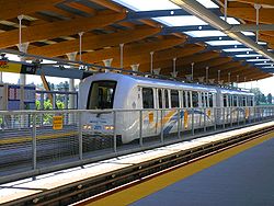
of (The Electors Action Movement). Phillips and TEAM campaigned on rehabilitating Gastown, whereas the NPA slate tended to strongly support the failed freeway project through East Vancouver. - 1985 - The SkyTrainSkyTrain (Vancouver)SkyTrain is a light rapid transit system in Metro Vancouver, British Columbia, Canada. SkyTrain has of track and uses fully automated trains on grade-separated tracks, running mostly on elevated guideways, which helps SkyTrain to hold consistently high on-time reliability...
rapid transitRapid transitA rapid transit, underground, subway, elevated railway, metro or metropolitan railway system is an electric passenger railway in an urban area with a high capacity and frequency, and grade separation from other traffic. Rapid transit systems are typically located either in underground tunnels or on...
system (current Expo Line) was built to connect downtown Vancouver to Surrey and included five stations in East Vancouver. - 1986 - The City hosted a World's FairWorld's FairWorld's fair, World fair, Universal Exposition, and World Expo are various large public exhibitions held in different parts of the world. The first Expo was held in The Crystal Palace in Hyde Park, London, United Kingdom, in 1851, under the title "Great Exhibition of the Works of Industry of All...
(Expo 86Expo 86The 1986 World Exposition on Transportation and Communication, or simply Expo '86, was a World's Fair held in Vancouver, British Columbia, Canada from Friday, May 2 until Monday, October 13, 1986...
) on the old rail yard properties at False CreekFalse CreekFalse Creek is a short inlet in the heart of Vancouver. It separates downtown from the rest of the city. It was named by George Henry Richards during his Hydrographic survey of 1856-63. Science World is located at its eastern end and the Burrard Street Bridge crosses its western end. False Creek is...
. Residential densification began to accelerate in this area.
- 1986 to 1993 - The Non-Partisan AssociationNon-Partisan AssociationThe Non-Partisan Association is a civic-level electoral organization in Vancouver, British Columbia, Canada. There are, and have also been in the past, Non-Partisan Association political parties in the nearby municipalities of Burnaby, Richmond and Surrey.The NPA was established in 1937 to...
returned to Vancouver City Hall, with former realtor and businessman Gordon Campbell as mayor. The NPA worked more closely with developers, passing a series of pro-development by-laws. Many seniors and poor renters are evicted from properties throughout the city, including Gastown. - 1994 - The lease expired on the Pacific National Exhibition grounds at Hastings Park. Extensions were granted by Vancouver City Council. The final year for the Exhibition was to be 1997, 100 years after it started operating in Hastings Park.
- 2002 - The Millennium LineMillennium LineThe Millennium Line is the second rapid transit line built in the SkyTrain light metro rapid transit system in Metro Vancouver, British Columbia, Canada. The line is owned and operated by TransLink. Millennium Line uses the colour yellow on route maps, wayfinding and station signage.-History:When...
of SkyTrain opened, providing new rapid transit service through East Vancouver. - 2004 - The provincial government transferred authority for the PNE to the City of Vancouver. A consultation process was initiated to determine a new future for the PNE in Hastings Park.
Neighbourhoods, demographics and languages
The 2001 census identified almost 550,000 in the city of VancouverVancouver
Vancouver is a coastal seaport city on the mainland of British Columbia, Canada. It is the hub of Greater Vancouver, which, with over 2.3 million residents, is the third most populous metropolitan area in the country,...
(Metro Vancouver has about 2.25 million residents).

Grandview-Woodland
Grandview-Woodland, also commonly known as Grandview-Woodlands, is a neighbourhood in Vancouver, British Columbia, Canada to the east of the downtown area, stretching south from the shores of Burrard Inlet and encompassing portions of the popular Commercial Drive area...
, Hastings-Sunrise
Hastings-Sunrise
Hastings-Sunrise is a neighbourhood located in the northeastern corner of the city of Vancouver, British Columbia.The name "Hastings" is a common and historical one in Vancouver for roads, businesses and even a townsite. It is commonly thought to have been derived from the Battle of Hastings from...
, Kensington-Cedar Cottage
Kensington-Cedar Cottage
Kensington-Cedar Cottage is one of the most ethnically diverse neighbourhoods in east Vancouver, British Columbia, Canada. The neighbourhood, which is 7.23 square kilometres in area, is bordered by Fraser St. on the west, Nanaimo St. on the east, 41st Avenue on the south and 16th Avenue and...
, Killarney, Renfrew-Collingwood
Renfrew-Collingwood
Renfrew–Collingwood is a large neighbourhood that lies on the eastern side of Vancouver, on its boundary with Burnaby and encompassing an area that was one of the earlier developed regions of the city. It is a diverse area that includes a substantial business community in several areas, as well as...
, Strathcona and Victoria-Fraserview
Victoria-Fraserview
Victoria-Fraserview is a neighbourhood in the City of Vancouver, set on the south slope of the rise that runs north from the Fraser River and encompassing a large area of residential and commercial development...
. The 2001 census identified 220,490 people living in these communities (approximately 40% of the city's population).
Two communities, Mount Pleasant and Riley Park-Little Mountain
Riley Park-Little Mountain
Riley Park–Little Mountain is a neighbourhood in Vancouver, British Columbia. Its boundaries are 41st Avenue in the south, 16th Avenue in the north, Cambie Street in the west and Fraser Street in the east. The main commercial thoroughfare of the neighbourhood is Main Street.-Parks:Little Mountain...
, straddle both East Vancouver and the West Side.
Two communities are part of East Vancouver but often referred to separately because of their unique place in the city's fabric: the Downtown Eastside
Downtown Eastside
The Downtown Eastside is one of the oldest neighbourhoods in Vancouver, British Columbia, Canada and is known as "Canada's poorest postal code"....
and Chinatown.
In addition to East Vancouver, the City of Vancouver is made up of the West End, Downtown, Downtown Eastside, and West Side. The Downtown area is further differentiated into Coal Harbour, Yaletown, Gastown, and other semi-distinct regions.
While the overall mother tongue in the City of Vancouver is 49% English and 26% Chinese (2001), areas of East Vancouver represent a more diverse ethnic population (e.g. residents of Victoria-Fraserview identified their mother tongue as 27% English and 49% Chinese). Note that all other mother tongues (e.g., Punjabi) were identified by fewer than 3% each of the City's population.
Community identity
East Vancouver has a strong geographic and community identity. This identity is about a diverse community living together within a dynamic urban neighbourhood. This diverse identity is strengthened by many active ethnic communities, a vibrant artistic presence, a politically engaged youth population, and vocal sexual-orientation and gender-identity groups.The political identity of the community is reinforced by newspapers such as the Republic of East Vancouver newspaper
The Republic (newspaper)
The Republic is a liberal local paper, published fortnightly from 2000 to 2008, in East Vancouver, an area of Vancouver, British Columbia, Canada....
(the name of which invokes a long-time joking reference to the left-leaning nature of the community and its labour history) and frequent political and social activism - such as the Commercial Drive Car Free Festival and protests.
The artistic identity is reinforced by events at the Vancouver East Cultural Centre, a community poetry anthology ("East of Main"), the Eastside Culture Crawl, and "the Drift", an annual event where local artists present their work centred around Main Street.
While many East Vancouver residents are proud of the diversity in their community, some perceive a long prejudice against East Side neighbourhoods. These concerns include the protests against the 1960s effort to push a freeway through (and over) parts of the East Side, to a perception that municipal spending and planning favours other areas of the city (especially the West Side), to recent debates, such as expansion of the Port of Vancouver operation in East Vancouver and the expansion of the Port Mann bridge and predicted increased traffic through the East Side.
Mayor Sam Sullivan's plans for increased population in Vancouver with "ecodensity" includes coach houses and densification plans via zoning changes mainly for the East Side, with few plans to change zoning or densify the West Side.
Ethnic communities in East Vancouver
European ethnicities
Early European settlers in East Vancouver were largely Irish, British, Scottish and Welsh. Today, evidence of these early settlers from Britain and Ireland is found in places such as the Cambrian Hall (built 1929) for the first Welsh Society in Vancouver (est. 1908). Modern British/Irish communities are still active in East Vancouver today, notably at the WISE Hall ("WISE" is an acronym for Welsh-Irish-Scottish-English) and the Vancouver Irish Céili Society.Italian immigrants formed the first "Little Italy" in the Main Street area by 1910 and then the Commercial Drive area in the 1950s (where Italian businesses and residents are still plentiful). An Italian Cultural Centre opened nearby on the Grandview Highway in the 1970s. Italian commercial and cultural life is also prevalent on Hastings around Nanaimo, and from there eastwards into the Burnaby Heights
Burnaby Heights
Burnaby Heights, officially known as Vancouver Heights and commonly referred to as The Heights, is a quiet, prestigious residential neighbourhood in North Burnaby between Boundary Road to the west, Gamma Avenue to the east and bounded by Hastings Street to the south...
region of North Burnaby.
While Greek immigrants mostly moved to Vancouver's West Side (e.g. Hellenic Cultural Community Centre on Arbutus Street) there were also strong communities in East Vancouver, particularly near Boundary Road (which divides Vancouver from the eastern municipality, Burnaby). In the 1960s, the number of Greek immigrants to Vancouver doubled in the 1960s, although this has declined steadily since the late 1960s.
Other visible European communities that have settled in East Vancouver include Polish (e.g. the Polish Veterans Association Meeting Hall on Kingsway, the Polish Hall on Fraser Street), German (Alpine Club of Canada hall on Victoria Drive), Croatian (the Croatian Cultural Centre near Trout Lake, the Croatian Catholic Church on 1st Avenue).
Asian
Vancouver
Vancouver is a coastal seaport city on the mainland of British Columbia, Canada. It is the hub of Greater Vancouver, which, with over 2.3 million residents, is the third most populous metropolitan area in the country,...
was incorporated (1886) and shortly after that date became established at today's Chinatown. Chinese immigration to the city grew significantly after 1947 when racial immigration exclusion laws were removed by the BC Government. Since the 1980s, many Chinese immigrants now choose to live outside of Chinatown, including elsewhere in East Vancouver (e.g. Victoria Drive area) and Richmond. Immigrants from Hong Kong began to move to the Vancouver area from the 1990s, concerned about the transfer of the territory from the UK to the Chinese. These immigrants were often wealthier than previous waves of Chinese immigrants and typically moved to non-Chinese communities in the West Side and elsewhere.
Chinese remains the dominant ethnicity in the City of Vancouver (about 33% of the city's students learn Chinese prior to learning English). Greater Vancouver has North America’s highest percentage of residents of Chinese descent (16%) and of this, 80% are foreign-born.
A wave of immigrants from South East Asian countries (e.g. Vietnam, Philippines, Indonesia) has moved to East Vancouver since the 1970s. Although many of these immigrants have since relocated to City of Richmond as part of the "Asia West" movement. Kingsway
Kingsway (Vancouver)
Kingsway is a major road that crosses through the Canadian cities of Vancouver and Burnaby, British Columbia. Originally called Westminster Road, it was renamed Kingsway in 1913....
Street in East Vancouver has many South East Asian businesses, such as Vietnamese restaurants, cafes and beauty shops. In 2003, about 5% of Vancouver's students speak Vietnamese as their first language .
Asian communities are served in East Vancouver by the Cantonese Families Mutual Sharing and Support Group and the Vietnamese Seniors Outreach Program, both on Commercial Drive.
South Asian
Since the 1990s, increasing numbers of Vancouver's South Asian residents have since relocated to other areas of Greater Vancouver and the Fraser Valley, particularly SurreySurrey, British Columbia
Surrey is a city in the province of British Columbia, Canada. It is a member municipality of Metro Vancouver, the governing body of the Greater Vancouver Regional District...
and Abbotsford
Abbotsford, British Columbia
Abbotsford is a Canadian city located in the Lower Mainland of British Columbia, adjacent to Greater Vancouver. It is the fifth largest municipality in British Columbia, home to 123,864 people . Its Census Metropolitan Area, which includes the District of Mission, is the 23rd largest in Canada,...
.
Hispanic
The Hispanic community in East Vancouver is served by the Canadian Latin American Cultural Society on Commercial Drive.African
The African population is served by the African Canadian Association of BC and the African-American Seniors Support Group, both on Commercial Drive.Kingsway
Today, it is one of the longer streets in the Greater Vancouver area (connecting Vancouver, Burnaby and New Westminster). Its length and varied services make it difficult to characterize; common businesses include diverse ethnic restaurants/cafés, specialty grocery stores, and many others.
Key shopping areas along Kingsway in East Vancouver include SoMa (South Main), Cedar Cottage/Dickens (from Fraser to Knight Streets), and Collingwood.
Main Street
Main Street north of Hastings is effectively part of the Downtown EastsideDowntown Eastside
The Downtown Eastside is one of the oldest neighbourhoods in Vancouver, British Columbia, Canada and is known as "Canada's poorest postal code"....
and includes the former headquarters of the Vancouver City Police and the Vancouver Pre-Trial Centre. Adjoining side-streets are largely small industry and warehouse, though verging quickly on Gastown
Gastown
Gastown is a national historic site in Vancouver, British Columbia, at the northeast end of Downtown adjacent to the Downtown Eastside. Its historical boundaries were the waterfront , Columbia Street, Hastings Street, and Cambie Street, which were the borders of the 1870 townsite survey, the proper...
to the west and Japantown
Japantown (Vancouver)
Japantown, Little Yokohama, or Little Tokyo is an old neighbourhood in Vancouver, British Columbia, north of Chinatown, that once had a concentration of Japanese immigrants. It was attacked on 7 September 1907 by the Asiatic Exclusion League, which smashed many windows in parts of Chinatown, and...
to the east.
Main Street
Main Street (Vancouver)
Main Street is a major north-south thoroughfare bisecting Vancouver, British Columbia, Canada. It runs from Waterfront Road by Burrard Inlet in the north, to Kent Avenue alongside the north arm of the Fraser River in the south.-Route:...
between East Hastings
Hastings Street (Vancouver)
Hastings Street is one of the most important east-west traffic corridors in the cities of Vancouver and Burnaby, British Columbia, Canada, and used to be a part of the decommissioned Highway 7A...
and East Georgia Streets is part of Chinatown
Chinatown (Vancouver)
Chinatown in Vancouver, British Columbia is Canada's largest Chinatown. Centred on Pender Street, it is surrounded by Gastown and the Downtown Financial and Central Business Districts to the west, the Downtown Eastside to the north, the remnant of old Japantown to the northeast, and the...
. This area has many Chinese businesses, particularly restaurants, small pottery and furniture stores, financial establishments, clothing stores and others. These businesses also extend to the east and the west of Main Street in this area. A popular Chinese New Year parade is held each year in this area.
Main Street is the core of the Mount Pleasant neighbourhood between East 2nd/Great Northern Way and East 19th Avenues. This area is known for a younger, hip demographic. Common businesses include cafés, grocery stores, pubs, vintage clothing
Vintage clothing
Vintage clothing is a generic term for new or second hand garments originating from a previous era. The phrase is also used in connection with a retail outlet, e.g...
stores, independent media stores. There are fewer recent immigrants in this area and it is also much more influenced by people in their 20s and 30s.
Mid-Main (between East 20th and East 30th Avenues)
This area of Main Street is dominated by antique stores, restaurants, bars, cafés, clothing stores, bookstores, grocery stores, and independent video stores.
The South Asian District, or Punjabi Market is between E 48th to E 51st Avenue.
South-East Marine Drive, between E 65th Avenue and SE Marine Drive and south to E Kent Avenue, has industrial and highway oriented retail.
Fraser Street
Fraser Street has two main shopping areas; a multi-ethnic (Chinese, Vietnamese, Filipino, Russian area) between East 24th and East 28th Avenues; and, between East 43rd and East 50th Avenues, one of Vancouver's several "Little Indias".Commercial Drive
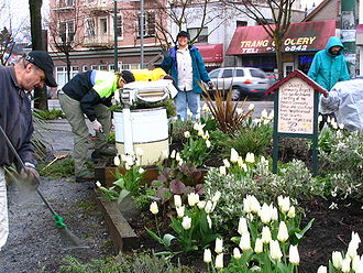
Commercial Drive (between Venables to E 12th Avenue) is one of the most vibrant areas of the Greater Vancouver region due to it strong multi-ethnic and activist identities. Culturally, this area is defined by the historic Italian and Portuguese communities, which developed a "Little Italy" here in the 1950s. Since that time, immigrants from Latin America, Asia, the Caribbean, Middle East and elsewhere mix with a strong aboriginal community to form a dynamic neighbourhood. Many residents from elsewhere in the city come to this area for shopping (e.g. Italian cheeses), restaurants, bars, cafés and the arts.The Commercial Drive area consistently ranks highly by city residents for many amenities, including "best neighbourhood", "best local microbrewery", "best place to eat meat", and "best potential hipster hangout".
Largely due to the activism and independent arts and culture scene of the area, the Hipster Handbook identifies Commercial Drive as the only area in the Greater Vancouver region as an "Indigenous Zone of the Hipster in the United States and Canada".
Victoria Drive
Victoria Drive, between East 36th and East 43rd Avenues, is a vibrant Chinese community with many restaurants, grocery stores and other services.Victoria Drive, between Hastings and 1st avenue is full of tight knit communities boasting community gardens, village corner stores and plant shops, 100 year old heritage homes, and block parties all summer. Most homes are beautifully painted and have been remodeled so they look exactly as they did 100 years ago.
Hastings Street
Hastings Street, which runs from downtown Vancouver in the west through Burnaby in the east, has many unique shopping areas. Closer to downtown and Chinatown, a thriving street culture includes many low-income, drug addicted and homeless people, but also a close-knit community of social activists. Local business includes pawn shops, cheap residency hotels, and a busy informal street market in illicit drugs.Further east between Clark and Nanaimo, the street's commercial presence includes marine and transport services, as well as artist studios and the infamous "chicken factories" which sometimes permeate the area with their characteristic odour. Between Nanaimo and Rupert is the Hastings Sunrise area, a busy commercial area of Asian and European shops and restaurants, as well as banks and other services.
Housing, affordability and gentrification
In May 2007, the typical housing ("benchmark") price of a single-detached house in East Vancouver was $627,758 (a 9% increase over the previous year and a 90% increase over the previous five years). Many home owners in East Vancouver rent out their basement suites to assist with mortgage payments.Increased housing prices are causing changes in East Vancouver neighbourhoods, such as fewer new immigrants moving to the area and decreasing affordability for artists, seniors, young families and others.
Affordable housing
Affordable housing is a term used to describe dwelling units whose total housing costs are deemed "affordable" to those that have a median income. Although the term is often applied to rental housing that is within the financial means of those in the lower income ranges of a geographical area, the...
options (e.g. townhouses)), more residential investment, neighbourhood-led artistic projects, more community-pride events (e.g. neighbourhood clean-ups, block parties and community gardening), and greater tax base for new amenities(e.g. a new planned library and $2.7 million in street, lighting and sidewalk improvements at Kingsway
Kingsway (Vancouver)
Kingsway is a major road that crosses through the Canadian cities of Vancouver and Burnaby, British Columbia. Originally called Westminster Road, it was renamed Kingsway in 1913....
and Knight Street).
Rising prices throughout the city have produced challenges for new social housing projects. This has caused conflict where East Vancouver residents feel that social housing projects are disproportionately located in their communities versus areas in Vancouver's West Side, some of which have no social housing at all (Dunbar, Kerrisdale and Shaughnessy)
Other general Vancouver housing concerns include increasing rental rates due to speculation
Speculation
In finance, speculation is a financial action that does not promise safety of the initial investment along with the return on the principal sum...
associated with the Vancouver 2010 Olympics and recent provincial economic growth.
Amenities and celebrations in East Vancouver
While the type of parks in East Vancouver is varied, one common element is the early morning t'ai chi practitioners. Other unique East Side park features include Trout Lake (the only lake in the city), the modern parkgrounds at Hastings Park, the large (38 ha.) and wild Everett Crowley Park, Kensington Park, where many wedding photographs are taken against the stunning backdrop of the city and North Shore MountainsNorth Shore Mountains
The North Shore Mountains are a mountain range overlooking Vancouver in British Columbia, Canada. Their southernmost peaks are visible from most areas in Vancouver and form a distinctive backdrop for the city....
, the bustling Refrew Community Park, the diverse Strathcona Park with its skatepark and climbing wall, and the multi-use Memorial Park, which is dedicated to soldiers who died in WW1 and today provides many spaces for sports teams and neighbours alike. Another park is the Falaise Park
Falaise Park
Falaise Park is a large urban park in East Vancouver, British Columbia, Canada. It is located on Vancouver-Burnaby border, between Rupert Street and Boundary Road, just south of Rupert Station of the Millennium Line....
on the border of Burnaby and Vancouver.
Public celebrations in East Vancouver
- Chinese New Year Parade at Main and Pender Streets (Late January or early February)
- Baisakhi Day Parade and vegetarian temple feast, near Marine Drive and Fraser Street (mid-April).
- Annual Cedar Cottage Mothers Day Traditional pow wow at Trout Lake Park (mid-May).
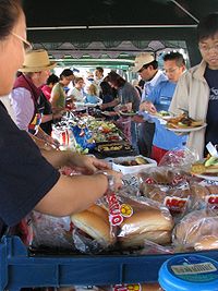
- East Vancouver Farmers Market
- Commercial Drive Car Free Festival (mid June)
- Illuminares (Lantern Festival) at Trout Lake Park. (end of July, always on Saturday, starting at dusk).
- Pacific National Exhibition (mid-August to Labour Day)
- East Vancouver Culture Crawl
- Vancouver Fringe Festival, centered on the Commercial Drive area (early September).
- ["The Drift" http://www.thedrift.ca] Main Street's Annual Art Festival and Open Studio Tour. First weekend in October. http://www.thedrift.ca
- Mid-autumn Moon Festival at Dr. Sun Yat-sen Garden (late September or early October).
- Parade of Lost Souls at Grandview Park (near Halloween).
Politics
Politically, East Vancouver has often supported left-wing political candidates although demographic changes since the 1990s (e.g. significantly increasing family income levels) may be causing voting patterns to become more diverse.At the municipal level, East Vancouver is part of the "at large" political system and therefore is represented by all of Vancouver City Council
Vancouver City Council
Vancouver City Council is the governing body of the City of Vancouver, British Columbia, Canada.The city is governed by the Vancouver Charter, not the Community Charter and the Local Government Act which are used for other municipal governments...
. In the 2008 municipal election, the Vision Vancouver
Vision Vancouver
Vision Vancouver is one of three parties represented on Vancouver City Council in Vancouver, British Columbia, Canada. Vision was formed in the months leading up to the 2005 municipal election.-Formation:...
became the controlling party at Vancouver's City Hall
Vancouver City Hall
Vancouver City Hall is home to Vancouver City Council in Vancouver, British Columbia. Located at 453 West 12th Avenue, the building was ordered by the Vancouver Civic Building Committee, designed by architect Fred Townley and Matheson, and built by Carter, Halls, Aldinger and Company...
.
Provincially, East Vancouver includes the constituencies of Vancouver-Kensington, Vancouver-Kingsway
Vancouver-Kingsway (provincial electoral district)
Vancouver-Kingsway is a provincial electoral district for the Legislative Assembly of British Columbia, Canada.- Demographics :- Member of Legislative Assembly :Its MLA is Adrian Dix. He was first elected in 2005...
, Vancouver-Hastings
Vancouver-Hastings
Vancouver-Hastings is a provincial electoral district for the Legislative Assembly of British Columbia, Canada.- Demographics :- Member of Legislative Assembly :Its MLA is Shane Simpson. He was first elected in 2005...
, Vancouver-Mount Pleasant
Vancouver-Mount Pleasant
Vancouver-Mount Pleasant is a provincial electoral district for the Legislative Assembly of British Columbia, Canada. It was one of only two electoral districts to return an NDP MLA in the 2001 election when the NDP was nearly wiped off the electoral map, and it did so by a much wider margin than...
and Vancouver-Fraserview
Vancouver-Fraserview
Vancouver-Fraserview is a provincial electoral district for the Legislative Assembly of British Columbia, Canada.- Demographics :- Geography :...
. In the 2005 provincial election, all constituencies in East Vancouver were won by the British Columbia New Democratic Party except Vancouver-Fraserview, which is represented by the British Columbia Liberal Party
British Columbia Liberal Party
The British Columbia Liberal Party is the governing political party in British Columbia, Canada. First elected for government in 1916, the party went into decline after 1952, with its rump caucus merging with the Social Credit Party for the 1975 election...
.
Federally, East Vancouver includes the ridings of Vancouver East
Vancouver East
Vancouver East is a federal electoral district in British Columbia, Canada, that has been represented in the Canadian House of Commons since 1935....
, Vancouver Kingsway
Vancouver Kingsway
Vancouver Kingsway is a federal electoral district in British Columbia, Canada that has been represented in the Canadian House of Commons from 1953 to 1988 and since 1997. It is located in Vancouver.-Demographics:...
and Vancouver South
Vancouver South
Vancouver South is a federal electoral district in British Columbia, Canada, that has been represented in the Canadian House of Commons from 1917 to 1997, and since 2004. It covers the southern portion of the city of Vancouver, British Columbia....
. In the 2011 federal election, Vancouver East and Vancouver Kingsway were won by the federal New Democratic Party
New Democratic Party
The New Democratic Party , commonly referred to as the NDP, is a federal social-democratic political party in Canada. The interim leader of the NDP is Nycole Turmel who was appointed to the position due to the illness of Jack Layton, who died on August 22, 2011. The provincial wings of the NDP in...
, while the Conservative Party of Canada
Conservative Party of Canada
The Conservative Party of Canada , is a political party in Canada which was formed by the merger of the Canadian Alliance and the Progressive Conservative Party of Canada in 2003. It is positioned on the right of the Canadian political spectrum...
won Vancouver South. This marked the first time since 1988 that the Tories managed to win a seat in Vancouver.