
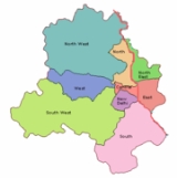
West Delhi
Encyclopedia

India
India , officially the Republic of India , is a country in South Asia. It is the seventh-largest country by geographical area, the second-most populous country with over 1.2 billion people, and the most populous democracy in the world...
.
West Delhi is bound by the districts of North West Delhi
North West Delhi
North West Delhi is an administrative district of the National Capital Territory of Delhi in India.-Geography:North West Delhi is bounded by the Yamuna River on the northeast, and by the districts of North Delhi to the east and southeast, West Delhi to the south, Jhajjar District of Haryana state...
to the north, North Delhi
North Delhi
North Delhi is an administrative district of the National Capital Territory of Delhi in India.North Delhi is bounded by the Yamuna River on the east, and by the districts of North West Delhi to the north and west, West Delhi to the southwest, Central Delhi to the south, and North East Delhi to the...
and Central Delhi
Central Delhi
Central Delhi is an administrative district of the National Capital Territory of Delhi in India.It is bounded by the Yamuna River on the east, and by the districts of North Delhi to the north, West Delhi and South West Delhi to the west, New Delhi to the south, and East Delhi to the east across the...
to the east, South West Delhi
South West Delhi
South West Delhi is an administrative district of the National Capital Territory of Delhi in India.South West Delhi is bounded by the districts of West Delhi to the north, Central Delhi to the northeast, New Delhi and South Delhi to the east, Gurgaon District of Haryana state to the south, and...
to the south, and Jhajjar District
Jhajjar District
Jhajjar district is one of the 21 districts of Haryana state in northern India.Jhajjar district was carved out of Rohtak district on July 15, 1997. The district headquarters is situated in Jhajjar. Other towns in the district are Bahadurgarh and Beri. Bahadurgarh was founded by Rathi Jats and...
of Haryana
Haryana
Haryana is a state in India. Historically, it has been a part of the Kuru region in North India. The name Haryana is found mentioned in the 12th century AD by the apabhramsha writer Vibudh Shridhar . It is bordered by Punjab and Himachal Pradesh to the north, and by Rajasthan to the west and south...
state to the west.
West Delhi has an area of 129 km², with a population density of nearly 14,000 persons per km². The population of 1,743,980 consists of 949,750 males and 794,230 females. Children between 0–6 years are 203,528 consisting of 109,526 boys and 94,002 girls. The literacy rate is above 70% at a total of 1,301,252 of which 739,572 are males and 561,680 females.
Administratively, the district is divided into three subdivisions, Patel Nagar
Patel Nagar
Patel Nagar is a place in West Delhi and it is the subdivision of West Delhi District as like other subdivisions Rajouri Garden and Punjabi Bagh.-Area:Patel Nagar is a large area and divided in some colonies like:*West Patel Nagar...
, Rajouri Garden
Rajouri Garden
Rajouri Garden is an upscale residential neighborhood in West Delhi, India. Located in West Delhi, its population includes a heavy majority of Punjabi Hindus and Sikhs...
, and Punjabi Bagh
Punjabi Bagh
Punjabi Bagh is one of the prominent and well-developed localities of Delhi, India. It also is one of the three subzones of West Delhi.It is one of the most popular, posh & costliest places in Delhi....
. Major residential and commercial areas like Janakpuri
Janakpuri
Janakpuri is a major residential colony in West Delhi, India. It is divided into four major blocks namely A,B,C and D which are then divided into sub-blocks e.g. A1, A2, A3, B, C1, C-2, C-2, C-3, C-4-A and so on...
and Tilak Nagar are located in West Delhi.
Demographics
According to the 2011 census2011 census of India
The 15th Indian National census was conducted in two phases, houselisting and population enumeration. Houselisting phase began on April 1, 2010 and involved collection of information about all buildings...
has a population
Demographics of India
The demographics of India are inclusive of the second most populous country in the world, with over 1.21 billion people , more than a sixth of the world's population. Already containing 17.5% of the world's population, India is projected to be the world's most populous country by 2025, surpassing...
of 2,531,583 , roughly equal to the nation of Kuwait
Kuwait
The State of Kuwait is a sovereign Arab state situated in the north-east of the Arabian Peninsula in Western Asia. It is bordered by Saudi Arabia to the south at Khafji, and Iraq to the north at Basra. It lies on the north-western shore of the Persian Gulf. The name Kuwait is derived from the...
or the US state of Nevada
Nevada
Nevada is a state in the western, mountain west, and southwestern regions of the United States. With an area of and a population of about 2.7 million, it is the 7th-largest and 35th-most populous state. Over two-thirds of Nevada's people live in the Las Vegas metropolitan area, which contains its...
. This gives it a ranking of 169th in India (out of a total of 640
Districts of India
A district is an administrative division of an Indian state or territory. Districts are further subdivided, in some cases into Sub-Divisions, and otherwise directly into tehsils or talukas.District officials include:...
). The district has a population density of 19625 PD/sqkm . Its population growth rate
Family planning in India
Family planning in India is based on efforts largely sponsored by the Indian government. In the 1965-2009 period, contraceptive usage has more than tripled and the fertility rate has more than halved , but the national fertility rate is still high enough to cause long-term population growth...
over the decade 2001-2011 was 18.91 %. West Delhi has a sex ratio
Sex ratio
Sex ratio is the ratio of males to females in a population. The primary sex ratio is the ratio at the time of conception, secondary sex ratio is the ratio at time of birth, and tertiary sex ratio is the ratio of mature organisms....
of 876 females
Women in India
The status of women in India has been subject to many great changes over the past few millennia. From equal status with men in ancient times through the low points of the medieval period, to the promotion of equal rights by many reformers, the history of women in India has been eventful...
for every 1000 males, and a literacy rate
Literacy in India
Literacy in India is key for socio-economic progress, and the Indian literacy rate grew to 74.04% in 2011 from 12% at the end of British rule in 1947. Although this was a greater than sixfold improvement, the level is well below the world average literacy rate of 84%, and India currently has the...
of 87.12 %.
See also
- Districts of Delhi
- NajafgarhNajafgarhNajafgarh is located at the outskirts of the southwestern part of New Delhi, India.It has a mixture of Rural and Urban population from New Delhi and Haryana.-Overview:...
- Indira Gandhi International AirportIndira Gandhi International AirportIndira Gandhi International Airport is the primary international airport of the National Capital Region of Delhi, India, situated in West Delhi, 16 km southwest of New Delhi city centre. Named after Indira Gandhi, the former Prime Minister of India, it is the busiest airport in India in...
- Ashok Nagar (Delhi)Ashok Nagar (Delhi)Ashok Nagar is a place near Tilak Nagar in New Delhi. It was known as Tihar 2 before being renamed as Ashok Nagar. Ashok Nagar is a part of Tilak Nagar assembly constituency and West Delhi parliamentary constituency. It used to be a part of Tihar Village like Subhash Nagar but it's known as Ashok...
- Tilak NagarTilak NagarTilak Nagar , Delhi is one of the suburban areas in West Delhi. It is approximately seventeen kilometers from the New Delhi Railway Station and twenty-two kilometers from the Indira Gandhi International Airport. Tilak Nagar is connected by the Delhi Metro to Connaught Place, making it easy for...
- JanakpuriJanakpuriJanakpuri is a major residential colony in West Delhi, India. It is divided into four major blocks namely A,B,C and D which are then divided into sub-blocks e.g. A1, A2, A3, B, C1, C-2, C-2, C-3, C-4-A and so on...
- VikaspuriVikaspuriVikaspuri is a Upper Middle Class residential locality within Delhi, India. Started by the Delhi Development Authority in the 1980s, it boomed in population in the late 1990s....
- Paschim ViharPaschim ViharPaschim Vihar is an upmarket residential colonies in Delhi, India. It falls under Punjabi Bagh subzone of West Delhi. Located in the western part of Delhi, Paschim Vihar mostly comprises housing complexes, bungalows, and some commercial complexes. Settlements here started around late 1970s and...
- Punjabi BaghPunjabi BaghPunjabi Bagh is one of the prominent and well-developed localities of Delhi, India. It also is one of the three subzones of West Delhi.It is one of the most popular, posh & costliest places in Delhi....
- Rajouri GardenRajouri GardenRajouri Garden is an upscale residential neighborhood in West Delhi, India. Located in West Delhi, its population includes a heavy majority of Punjabi Hindus and Sikhs...
- Dhaula KuanDhaula KuanDhaula Kuan is a major intersection of roads in Delhi, India. The name also now refers to the neighborhood surrounding the intersection. It lies in South West Delhi.-Intersection:Five major throughfares in Delhi meet at Dhaula Kuan...
- Patel NagarPatel NagarPatel Nagar is a place in West Delhi and it is the subdivision of West Delhi District as like other subdivisions Rajouri Garden and Punjabi Bagh.-Area:Patel Nagar is a large area and divided in some colonies like:*West Patel Nagar...
- Dwarka
- Dashrath puriDashrath puriDashrath Puri is a small colony consisting of around 1000 houses situated on Palam-Dabri road in West Delhi, India. Currently this colony comes under Dwarka Vidhansabha constituency and West Delhi Dashrath Puri is a small colony consisting of around 1000 houses situated on Palam-Dabri road in West...
- South DelhiSouth DelhiSouth Delhi is an administrative district of the National Capital Territory of Delhi in India.It is bounded by the Yamuna River to the east, the districts of New Delhi to the north, Faridabad District of Haryana state to the southeast, Gurgaon District of Haryana to the southwest, and South West...
- Hari Nagar
- Subhash Nagar
- Uttam Nagar
- Shadipur DepotShadipur DepotShadipur Depot is a residential and industrial area in West Delhi, named after nearby Shadipur settlement. This is also a depot for the Delhi Transport Corporation...
- Naraina Ind. Area