

Waterford Covered Bridge
Encyclopedia
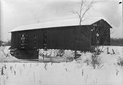
The Waterford Covered Bridge is an 86 feet (26.2 m) Town lattice truss covered bridge
crossing LeBoeuf Creek
in Waterford Township, Erie County
in the U.S. state
of Pennsylvania
. It was built in 1875 and was listed on the National Register of Historic Places
on September 17, 1980. The bridge was documented by the Historic American Buildings Survey
in 1936.
It is the only Town lattice truss bridge in Erie County and one of only nineteen in Pennsylvania. The bridge structure's sufficiency rating on the Federal Highway Administration
National Bridge Inventory
was only 18.4 percent and its condition was deemed "basically intolerable requiring high priority of replacement."
. The bridge is located 0.7 miles (1.1 km) from Waterford on Niemeyer Road (Township Road 463), which intersects Water Street in Waterford 0.3 mile (0.482802 km) off of U.S. Route 19
. The bridge crosses the LeBoeuf Creek, a tributary of French Creek
.
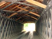
The bridge was designed by Richard Cross using a Town lattice truss. The Town lattice truss was patented by Ithiel Town
in 1832 and was used to make bridges with small, light pieces instead large, heavy pieces that were more expensive to make. They are only nineteen Town lattice truss bridges remaining in Pennsylvania and the Waterford Covered Bridge is only one in Erie County. The bridge also has "an unusual, blue, metal pipe structure" on the exterior of the bridge's south side supported with a king post
framework.
 The Waterford Covered Bridge was built in 1875 by the brothers Charles and James Phelps.
A sign that was mounted on the gable
of one of portals of the bridge said, "Old Kissing Bridge built in 1875 the Phelps Bros." The sign has since been taken down.
In 2001, Waterford Township was given a $54,000 grant by the Pennsylvania Historical and Museum Commission
(PHMC) to replace the rafters, roofing, and shake shingles on the bridge.
box truck
attempted to cross the bridge. The second incident occurred on December 9, 2005 involving a FedEx
truck that was 8 inches (20.3 cm) taller than the bridge's 10 feet (3 m) clearance and 3580 pounds (1,623.9 kg) over the bridge's posted 3 ton load limit. Several of the bridge's deck plank
s, support beams, and cross pieces were damaged, although the bridge's integrity was not compromised and was never closed to traffic.
 Evans' 2001 Pennsylvania's covered bridges: a complete guide described the bridge as being "in fairly poor condition." The Federal Highway Administration
National Bridge Inventory
found the sufficiency rating of the bridge structure to be only 18.4 percent. It found that the bridge's foundations were determined "to be stable for assessed scour conditions," and that the railing "does not meet currently acceptable standards". Its overall condition was deemed "basically intolerable requiring high priority of corrective action", with an estimated cost to improve the bridge of $
750,000.
 The following table is a comparison of published measurements of length, width and load recorded in different sources using different methods, as well as the name or names cited. NBI measures bridge length between the "backwalls of abutments" or pavement grooves and the roadway width as "the most restrictive minimum distance between curbs or rails". The NRHP form was prepared by the Pennsylvania Historical and Museum Commission, which surveyed county engineers, historical and covered bridge societies, and others for all the covered bridges in the commonwealth. The Evans visited every covered bridge in Pennsylvania in 2001 and measured each bridge's length (portal to portal) and width (at the portal) for their book. The article uses primarily the NBI and NRHP data, as they are national programs.
Covered bridge
A covered bridge is a bridge with enclosed sides and a roof, often accommodating only a single lane of traffic. Most covered bridges are wooden; some newer ones are concrete or metal with glass sides...
crossing LeBoeuf Creek
LeBoeuf Creek
LeBoeuf Creek is an long tributary of French Creek in Erie County, Pennsylvania in the United States. It has a drainage basin of .- Course :...
in Waterford Township, Erie County
Erie County, Pennsylvania
Erie County is a county located in the U.S. state of Pennsylvania. As of 2010, the population was 280,566. Its county seat is the City of Erie.- Geography :...
in the U.S. state
U.S. state
A U.S. state is any one of the 50 federated states of the United States of America that share sovereignty with the federal government. Because of this shared sovereignty, an American is a citizen both of the federal entity and of his or her state of domicile. Four states use the official title of...
of Pennsylvania
Pennsylvania
The Commonwealth of Pennsylvania is a U.S. state that is located in the Northeastern and Mid-Atlantic regions of the United States. The state borders Delaware and Maryland to the south, West Virginia to the southwest, Ohio to the west, New York and Ontario, Canada, to the north, and New Jersey to...
. It was built in 1875 and was listed on the National Register of Historic Places
National Register of Historic Places
The National Register of Historic Places is the United States government's official list of districts, sites, buildings, structures, and objects deemed worthy of preservation...
on September 17, 1980. The bridge was documented by the Historic American Buildings Survey
Historic American Buildings Survey
The Historic American Buildings Survey , Historic American Engineering Record , and Historic American Landscapes Survey are programs of the National Park Service established for the purpose of documenting historic places. Records consists of measured drawings, archival photographs, and written...
in 1936.
It is the only Town lattice truss bridge in Erie County and one of only nineteen in Pennsylvania. The bridge structure's sufficiency rating on the Federal Highway Administration
Federal Highway Administration
The Federal Highway Administration is a division of the United States Department of Transportation that specializes in highway transportation. The agency's major activities are grouped into two "programs," the Federal-aid Highway Program and the Federal Lands Highway Program...
National Bridge Inventory
National Bridge Inventory
The National Bridge Inventory is a database, compiled by the Federal Highway Administration, with information on all bridges and tunnels in the United States that have roads passing above or below. This is similar to the grade crossing identifier number database compiled by the Federal Railroad...
was only 18.4 percent and its condition was deemed "basically intolerable requiring high priority of replacement."
Overview
The Waterford Covered Bridge is located in Waterford Township, just east of the borough of WaterfordWaterford, Pennsylvania
Waterford is a borough in Erie County, Pennsylvania, United States. The population was 1,449 at the 2000 census. It is part of the Erie Metropolitan Statistical Area.-Geography:Waterford is located at ....
. The bridge is located 0.7 miles (1.1 km) from Waterford on Niemeyer Road (Township Road 463), which intersects Water Street in Waterford 0.3 mile (0.482802 km) off of U.S. Route 19
U.S. Route 19
U.S. Route 19 is a north–south U.S. Highway. Despite encroaching Interstate Highways, the route has remained a long-haul route, connecting the Gulf of Mexico with Lake Erie....
. The bridge crosses the LeBoeuf Creek, a tributary of French Creek
French Creek (Allegheny River)
French Creek is a tributary of the Allegheny River in northwestern Pennsylvania and western New York in the United States.- Etymology :...
.
The bridge was designed by Richard Cross using a Town lattice truss. The Town lattice truss was patented by Ithiel Town
Ithiel Town
Ithiel Town was a prominent American architect and civil engineer. One of the first generation of professional architects in the United States, Town made significant contributions to American architecture in the first half of the 19th century. He was high-strung, sophisticated, generous,...
in 1832 and was used to make bridges with small, light pieces instead large, heavy pieces that were more expensive to make. They are only nineteen Town lattice truss bridges remaining in Pennsylvania and the Waterford Covered Bridge is only one in Erie County. The bridge also has "an unusual, blue, metal pipe structure" on the exterior of the bridge's south side supported with a king post
King post
A king post is a central vertical supporting post used in architectural, bridge, or aircraft design applications.-Architecture:...
framework.
History
A sign that was mounted on the gable
Gable
A gable is the generally triangular portion of a wall between the edges of a sloping roof. The shape of the gable and how it is detailed depends on the structural system being used and aesthetic concerns. Thus the type of roof enclosing the volume dictates the shape of the gable...
of one of portals of the bridge said, "Old Kissing Bridge built in 1875 the Phelps Bros." The sign has since been taken down.
In 2001, Waterford Township was given a $54,000 grant by the Pennsylvania Historical and Museum Commission
Pennsylvania Historical and Museum Commission
The Pennsylvania Historical and Museum Commission is the governmental agency of the Commonwealth of Pennsylvania responsible for the collection, conservation and interpretation of Pennsylvania's historic heritage...
(PHMC) to replace the rafters, roofing, and shake shingles on the bridge.
Modern use and status
The bridge was damaged twice when oversized trucks have attempted to cross it. The first incident occurred on June 17, 2003 when a Ford F-450Ford Super Duty
For the 1999 model year, Ford shifted the F-250 and F-350 truck lines to a design mechanically and cosmetically distinct from that of the F-150. The F-350 was not available for 1998, while the F-250 was available that year with the F-150's body...
box truck
Box truck
A box truck, also known as a cube truck, cube van, bob truck, box van, or straight truck, is a truck with a cuboid-shaped cargo area.-Road vehicles:...
attempted to cross the bridge. The second incident occurred on December 9, 2005 involving a FedEx
FedEx
FedEx Corporation , originally known as FDX Corporation, is a logistics services company, based in the United States with headquarters in Memphis, Tennessee...
truck that was 8 inches (20.3 cm) taller than the bridge's 10 feet (3 m) clearance and 3580 pounds (1,623.9 kg) over the bridge's posted 3 ton load limit. Several of the bridge's deck plank
Plank
Plank may refer to:*Plank *Plank , an isometric exercise for the abdominal muscles*The Plank , a British comedy film with no dialogue*The Plank , a remake of the 1967 film...
s, support beams, and cross pieces were damaged, although the bridge's integrity was not compromised and was never closed to traffic.
Federal Highway Administration
The Federal Highway Administration is a division of the United States Department of Transportation that specializes in highway transportation. The agency's major activities are grouped into two "programs," the Federal-aid Highway Program and the Federal Lands Highway Program...
National Bridge Inventory
National Bridge Inventory
The National Bridge Inventory is a database, compiled by the Federal Highway Administration, with information on all bridges and tunnels in the United States that have roads passing above or below. This is similar to the grade crossing identifier number database compiled by the Federal Railroad...
found the sufficiency rating of the bridge structure to be only 18.4 percent. It found that the bridge's foundations were determined "to be stable for assessed scour conditions," and that the railing "does not meet currently acceptable standards". Its overall condition was deemed "basically intolerable requiring high priority of corrective action", with an estimated cost to improve the bridge of $
United States dollar
The United States dollar , also referred to as the American dollar, is the official currency of the United States of America. It is divided into 100 smaller units called cents or pennies....
750,000.
Bridge dimensions
| Length feet (m) |
Width feet (m) |
Load short tons (MT) |
Source (Year) |
|---|---|---|---|
| 78 feet (23.8 m) | 13.7 feet (4.2 m) | 5.9 short tons (5.4 MT) | NBI National Bridge Inventory The National Bridge Inventory is a database, compiled by the Federal Highway Administration, with information on all bridges and tunnels in the United States that have roads passing above or below. This is similar to the grade crossing identifier number database compiled by the Federal Railroad... (2008) |
| 78 feet (23.8 m) | 15 feet (4.6 m) | 3 short tons (2.7 MT) | NRHP National Register of Historic Places The National Register of Historic Places is the United States government's official list of districts, sites, buildings, structures, and objects deemed worthy of preservation... (1979) |
| 85 in 11 in (26.19 m) | 15 in 1 in (4.6 m) | NA | Evans (2001) |
| 78 feet (23.8 m) | 15 feet (4.6 m) | NA | Zacher (1986) |