
Water glyphs
Encyclopedia
Water glyphs are a recurring type of petroglyph
found across the American southwest, but primarily in southern Utah
, northern Arizona
, and Nevada
. The symbols are thought to be of ancient origin, (perhaps created by the Ancient Pueblo Peoples
), and have been dated via x-ray fluorescence
to ~2,000 old by Dr. Farrel Lytle. Classification as a water glyph requires the presence of certain distinctive characteristics including both visual elements and location. Although the glyphs have likely been previously noted by local ranchers and farmers, the recurring pattern was first documented by Robert Ford and Dixon Spendlove of Fredonia, Arizona
. To date, more than 340 instances of these petroglyphs had been cataloged in an extensive GIS study.
 Water glyphs are usually 48 inches long by 24 inches wide, with grooves carved half an inch to an inch deep.
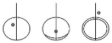
Examples of "Waterglyphs":
The position of the dot with respect to the glyph varies:
The circle may also contain additional arcs, or partial arcs, forming a crescent on one side of the ring, or a double ellipse; but the basic glyph remains the same.
.
.
Amateur archaeologists Robert Ford and Dixon Spendlove assert that the symbols were used by the Ancient Pueblo peoples to mark water sources in the desert. They assert that a high percentage of these symbols indicates line-of-sight directions to finding a natural spring, water pocket or pool, or ancient village site. They hypothesize that the symbols could be followed, from one water source to the next, across the entire Arizona Strip.
Opposing theories include use of these petroglyphs as astronomical/solstice markers, sacrificial altars or writings left by early Spanish explorers
.
. Maxwell later gave the same presentation at the 2006 Annual Meeting of the NAA in Mesquite Nevada.
Petroglyph
Petroglyphs are pictogram and logogram images created by removing part of a rock surface by incising, picking, carving, and abrading. Outside North America, scholars often use terms such as "carving", "engraving", or other descriptions of the technique to refer to such images...
found across the American southwest, but primarily in southern Utah
Utah
Utah is a state in the Western United States. It was the 45th state to join the Union, on January 4, 1896. Approximately 80% of Utah's 2,763,885 people live along the Wasatch Front, centering on Salt Lake City. This leaves vast expanses of the state nearly uninhabited, making the population the...
, northern Arizona
Arizona
Arizona ; is a state located in the southwestern region of the United States. It is also part of the western United States and the mountain west. The capital and largest city is Phoenix...
, and Nevada
Nevada
Nevada is a state in the western, mountain west, and southwestern regions of the United States. With an area of and a population of about 2.7 million, it is the 7th-largest and 35th-most populous state. Over two-thirds of Nevada's people live in the Las Vegas metropolitan area, which contains its...
. The symbols are thought to be of ancient origin, (perhaps created by the Ancient Pueblo Peoples
Ancient Pueblo Peoples
Ancient Pueblo People or Ancestral Pueblo peoples were an ancient Native American culture centered on the present-day Four Corners area of the United States, comprising southern Utah, northern Arizona, northwest New Mexico, and southern Colorado...
), and have been dated via x-ray fluorescence
Extended X-Ray Absorption Fine Structure
X-ray Absorption Spectroscopy includes both Extended X-Ray Absorption Fine Structure and X-ray Absorption Near Edge Structure . XAS is the measurement of the x-ray absorption coefficient of a material as a function of energy...
to ~2,000 old by Dr. Farrel Lytle. Classification as a water glyph requires the presence of certain distinctive characteristics including both visual elements and location. Although the glyphs have likely been previously noted by local ranchers and farmers, the recurring pattern was first documented by Robert Ford and Dixon Spendlove of Fredonia, Arizona
Fredonia, Arizona
Fredonia is a town in Coconino County, Arizona, United States. Fredonia is Arizona's northernmost town and the gateway to the North Rim of the Grand Canyon. Visitors enjoy seeing the Grand Canyon from the North Rim because they can experience the wonder and beauty without large crowds and high...
. To date, more than 340 instances of these petroglyphs had been cataloged in an extensive GIS study.
Visual Elements
- The symbol consists of a circle or ellipse bisected by a single straight line.
- The line usually extends beyond the edge of the circle on one side by a distance roughly equal to the diameter of the circle.
- Sometimes the extending line drops off the edge of the cliff or rock.
- The petroglyph usually contains a single deep depression, or "dot," within or near the circle.
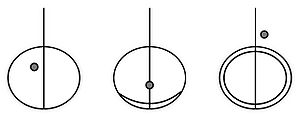
Examples of "Waterglyphs":
The position of the dot with respect to the glyph varies:
- It may be found outside or within the circle
- It may be found to the right or left of the bisecting line
- It may be found along one of the circular "horizon" lines.
The circle may also contain additional arcs, or partial arcs, forming a crescent on one side of the ring, or a double ellipse; but the basic glyph remains the same.
Location
Many petroglyphs and pictographs are located on cliff faces or under vertical overhangs, where they receive some limited protection from the elements. Water glyphs, however, typically lie along horizontal cliff edges or exposed rock surfaces. Occurrences of water glyphs are sometimes associated with the presence of Moki StepsMoki Steps
Moki steps, sometimes spelled alternately as Moqui steps, are a recurring feature found in areas of the American southwest previously inhabited by the Ancient Pueblo Peoples and other related cultures. The steps consist of alternating hand and toe holds carved into vertical or near-vertical...
.
Theories
In consideration of the orientations of the line and circle motifs within the pictographs, the authors of this research conclude that waterglyphs are directional makers pointing toward sources of water throughout the arid Arizona StripArizona Strip
The Arizona Strip is the part of the U.S. state of Arizona lying north of the Colorado River. The difficulty of crossing the Grand Canyon causes this region to have more natural connections with southern Utah and Nevada than with the rest of Arizona....
.
Amateur archaeologists Robert Ford and Dixon Spendlove assert that the symbols were used by the Ancient Pueblo peoples to mark water sources in the desert. They assert that a high percentage of these symbols indicates line-of-sight directions to finding a natural spring, water pocket or pool, or ancient village site. They hypothesize that the symbols could be followed, from one water source to the next, across the entire Arizona Strip.
Opposing theories include use of these petroglyphs as astronomical/solstice markers, sacrificial altars or writings left by early Spanish explorers
Dominguez-Escalante Expedition
The Dominguez-Escalante Expedition was conducted in 1776 to find an overland route from Santa Fe, New Mexico to Spanish missions in California...
.
Publications and Presentations
A paper entitled “Waterglyphs: Ancient Cartography of the Arizona Strip” was published in the September 2004 URARA Symposium Journal. The article was co-authored by Ford and Spendlove, along with David Maxwell of Southern Utah University. Maxwell went on to give a presentation entitled “Encoded Cultural Landscape Navigation – Waterglyphs; An Ancient Navigational System” at the October 2005 URURA Symposium held in Price, UtahPrice, Utah
Price is a city in Carbon County, Utah, United States. The city is home to the USU-College of Eastern Utah, as well as the large USU Eastern Prehistoric Museum affiliated with the college. Price is located within short distances from both Nine Mile Canyon and the Manti-La Sal National Forest...
. Maxwell later gave the same presentation at the 2006 Annual Meeting of the NAA in Mesquite Nevada.