

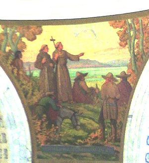
Dominguez-Escalante Expedition
Encyclopedia
Santa Fe, New Mexico
Santa Fe is the capital of the U.S. state of New Mexico. It is the fourth-largest city in the state and is the seat of . Santa Fe had a population of 67,947 in the 2010 census...
to Spanish missions in California
Spanish missions in California
The Spanish missions in California comprise a series of religious and military outposts established by Spanish Catholics of the Franciscan Order between 1769 and 1823 to spread the Christian faith among the local Native Americans. The missions represented the first major effort by Europeans to...
. Francisco Atanasio Domínguez and Silvestre Vélez de Escalante, Franciscan priests, and Don Bernardo Miera y Pacheco, a cartographer traveled with eight men from Santa Fe, through present day western Colorado to Utah Valley
Utah Valley
Utah Valley is a valley in North Central Utah located in Utah County, and is considered part of the Wasatch Front. It contains Provo, Orem, and their suburbs, including Highland, Eagle Mountain, Saratoga Springs, Mapleton, Spanish Fork, Lindon, Pleasant Grove, Springville, Lehi, Payson, and...
, now in the state of Utah. Along the journey they were aided by three Timpanog Ute guides. Due to hardships experienced during travel, the group did not make it to Las Californias
Las Californias
The Californias, or in — - was the name given by the Spanish to their northwestern territory of New Spain, comprising the present day states of Baja California and Baja California Sur on the Baja California Peninsula in Mexico; and the present day U.S. state of California in the United States of...
; they returned to Santa Fe through Arizona
Arizona
Arizona ; is a state located in the southwestern region of the United States. It is also part of the western United States and the mountain west. The capital and largest city is Phoenix...
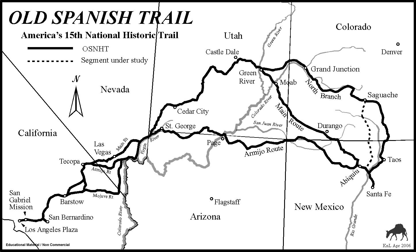
. The maps and documentation of their expedition aided future travelers. Their route became part of the Old Spanish Trail
Old Spanish Trail (trade route)
The Old Spanish Trail is a historical trade route which connected the northern New Mexico settlements near or in Santa Fe, New Mexico with that of Los Angeles, California and southern California. Approximately long, it ran through areas of high mountains, arid deserts, and deep canyons. It is...
from Santa Fe.
The expedition

Santa Fe, New Mexico
Santa Fe is the capital of the U.S. state of New Mexico. It is the fourth-largest city in the state and is the seat of . Santa Fe had a population of 67,947 in the 2010 census...
to Spanish missions in California
Spanish missions in California
The Spanish missions in California comprise a series of religious and military outposts established by Spanish Catholics of the Franciscan Order between 1769 and 1823 to spread the Christian faith among the local Native Americans. The missions represented the first major effort by Europeans to...
, such as the Spanish presidio
Presidio
A presidio is a fortified base established by the Spanish in North America between the sixteenth and nineteenth centuries. The fortresses were built to protect against pirates, hostile native Americans and enemy colonists. Other presidios were held by Spain in the sixteenth and seventeenth...
at Monterey
Monterey, California
The City of Monterey in Monterey County is located on Monterey Bay along the Pacific coast in Central California. Monterey lies at an elevation of 26 feet above sea level. As of the 2010 census, the city population was 27,810. Monterey is of historical importance because it was the capital of...
in Las Californias
Las Californias
The Californias, or in — - was the name given by the Spanish to their northwestern territory of New Spain, comprising the present day states of Baja California and Baja California Sur on the Baja California Peninsula in Mexico; and the present day U.S. state of California in the United States of...
. On July 29, 1776 Francisco Atanasio Domínguez led for the expedition from Santa Fe
Santa Fe, New Mexico
Santa Fe is the capital of the U.S. state of New Mexico. It is the fourth-largest city in the state and is the seat of . Santa Fe had a population of 67,947 in the 2010 census...
with fellow friar Silvestre Vélez de Escalante and cartographer Don Bernardo Miera y Pacheco. The initial part of their journey followed the route taken by Juan Rivera
Juan Rivera (explorer)
Juan Maria Antonio Rivera was an 18th century Spanish explorer who explored southwestern North America, including parts of Southern Rocky Mountains...
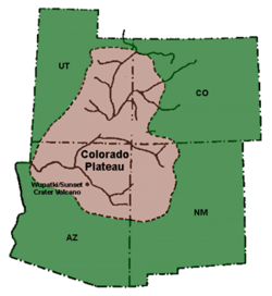
eleven years earlier into Ute country of southwestern Colorado. Three Timpanog Ute guides led them on their journey through northern Colorado, to Utah and back to Santa Fe. They were the first white men to travel the route through much of the Colorado Plateau
Colorado Plateau
The Colorado Plateau, also called the Colorado Plateau Province, is a physiographic region of the Intermontane Plateaus, roughly centered on the Four Corners region of the southwestern United States. The province covers an area of 337,000 km2 within western Colorado, northwestern New Mexico,...
into Utah and back through Arizona to New Mexico. During the course of their trip, they documented the route and provided detailed information about the "lush, mountainous land filled with game and timber, strange ruins of stone cities and villages, and rivers showing signs of precious metals."
Present day New Mexico
Santa Rosa de Abiquiú, July 30- The first night of the journey they stayed overnight at the Santa Clara puebloSanta Clara Pueblo, New MexicoSanta Clara Pueblo is a census-designated place in Rio Arriba County, New Mexico, United States. The population was 980 at the 2000 census. Santa Clara Pueblo was established about 1550....
, north of Santa Fe, and from there the men "traveled nine leaguesLeague (unit)A league is a unit of length . It was long common in Europe and Latin America, but it is no longer an official unit in any nation. The league originally referred to the distance a person or a horse could walk in an hour...
, more or less, and arrived at the pueblo of Santa Rosa de Abiquiú, where because of various circumstances we remained on the 31st without traveling, and where by means of a Solemn Mass we again implored the aid of our most holy patrons."
- From Santa Rosa de Abiquiú pueblo, they traveled north and northwest to a location near present-day Dulce, New MexicoDulce, New MexicoDulce is a census-designated place in Rio Arriba County, New Mexico, United States. The population was 2,623 at the 2000 census, almost entirely Native American...
.
Present day Colorado
Mesa Verde, August 10- From Dulce, they made their way into present day Colorado through ArbolesArboles, ColoradoArboles is a census-designated place in Archuleta County, Colorado, United States. The population was 280 at the 2010 census. The Arboles Post Office has the ZIP Code 81121...
, IgnacioIgnacio, ColoradoThe Town of Ignacio is a Statutory Town located in La Plata County, Colorado, United States. The population was 669 at the 2000 census.Located within the boundaries of the Southern Ute Indian Reservation, the town is the capital of the Southern Ute Indian tribe. It was named for their...
, DurangoDurango, ColoradoThe City of Durango is a Home Rule Municipality that is the county seat and the most populous city of La Plata County, Colorado, United States. The United States Census Bureau said that the city population was 16,887 in 2010 census.-History:...
and HeperusHesperus, ColoradoHesperus is an unincorporated town and a U.S. Post Office located in La Plata County, Colorado, United States. The Hesperus Post Office has the ZIP Code 81326.-See also:* Durango Micropolitan Statistical Area* Old Spanish National Historic Trail...
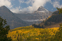
. The men camped at the base of the La Plata MountainsLa Plata MountainsThe La Plata Mountains are a small subrange of the San Juan Mountains in the southwestern part of Colorado, United States. They are located on the border between Montezuma and La Plata counties, about northwest of Durango. Their name is Spanish for silver.The peaks of the range are easily visible...
near the current Mesa Verde National ParkMesa Verde National ParkMesa Verde National Park is a U.S. National Park and UNESCO World Heritage Site located in Montezuma County, Colorado, United States. It was created in 1906 to protect some of the best-preserved cliff dwellings in the world...
in southwestern ColoradoSouthwestern ColoradoSouthwestern Colorado is a region in the southwest portion of Colorado. It is bordered by Western Colorado, Southern Colorado, the south portion of Central Colorado, Utah, and New Mexico.-Counties:*Alamosa County*Archuleta County*Conejos County*Dolores County...
. Escalante wrote in his journal, "Father Fray Francisco Atanasio [Domínguez] awoke troubled by rheumatic feverRheumatic feverRheumatic fever is an inflammatory disease that occurs following a Streptococcus pyogenes infection, such as strep throat or scarlet fever. Believed to be caused by antibody cross-reactivity that can involve the heart, joints, skin, and brain, the illness typically develops two to three weeks after...
which he felt in his face and head since the day before, and it was desirable that we make camp here until he should be better, but the continuous rains, the inclemency of the weather, and the great dampness of the place forced us to leave it. Going north, and having traveled a little more than half a leagueLeague (unit)A league is a unit of length . It was long common in Europe and Latin America, but it is no longer an official unit in any nation. The league originally referred to the distance a person or a horse could walk in an hour...
, we turned to the northwest, went on a league and then swung west through valleys of very beautiful timber and abundant pasturage, roses, and various other flowers. After going two leagues we were again caught in a very heavy rain. Father Fray Francisco Atanasio became worse and the road impassable, and so, having traveled with great difficulty two more leagues to the west, we had to camp on the bank of the first of two little rivers which form the San Lazaro, otherwise called Rio de los MancosMancos RiverMancos River is an tributary of the San Juan River. It flows from the confluence of West Mancos River and East Mancos River near Mancos, Colorado and joins the San Juan near Four Corners Monument in New Mexico.-See also:*List of rivers of Colorado...
. The pasturage continues in great abundance. Today four and a half leagues."
- The men camped alongside the Mancos RiverMancos RiverMancos River is an tributary of the San Juan River. It flows from the confluence of West Mancos River and East Mancos River near Mancos, Colorado and joins the San Juan near Four Corners Monument in New Mexico.-See also:*List of rivers of Colorado...
, on a few miles below where it runs into Mesa Verde. The river was named mancos meaning "one-handed" or "crippled" after one of the men fell into an river, injuring his name.
Escalante and Domínguez Pueblos, August 13
- Near present day DoloresDolores, ColoradoThe town of Dolores is a Statutory Town in Montezuma County, Colorado, United States. The population was 936 at the 2010 census. It is one of three incorporated municipalities in the county....
, Escalante and Domínguez found and recorded Anasazi ruins in southwestern ColoradoSouthwestern ColoradoSouthwestern Colorado is a region in the southwest portion of Colorado. It is bordered by Western Colorado, Southern Colorado, the south portion of Central Colorado, Utah, and New Mexico.-Counties:*Alamosa County*Archuleta County*Conejos County*Dolores County...
, the first white men to do so. Escalante Pueblo and Domínguez Pueblos, named for them, are located at the Anasazi Heritage CenterAnasazi Heritage CenterAnasazi Heritage Center, located in Dolores, Colorado, is an archaeological museum of Native American pueblo and hunter-gatherer cultures. Two 12th-century archaeological sites, the Escalante and Dominguez Pueblos, at the center were once home to Ancient Pueblo Peoples...
.
- As recorded of other potential settlement locations, Escalante noted the area's bounties: beautiful surroundings supplied with water, pasture, timber wood and fire wood. The men traveled north, staying east of the San Juan MountainsSan Juan MountainsThe San Juan Mountains are a high and rugged mountain range in the Rocky Mountains in southwestern Colorado. The area is highly mineralized and figured in the gold and silver mining industry of early Colorado. Major towns, all old mining camps, include Creede, Lake City, Silverton, Ouray, and...
. They crossed the Dolores RiverDolores RiverThe Dolores River is a tributary of the Colorado River, approximately 250 mi long, in the U.S. states of Colorado and Utah....
several times and then camped along its banks northeast of present-day CahoneCahone, ColoradoCahone is an unincorporated town and U.S. Post Office in Dolores County, Colorado, United States. The ZIP Code of the Cahone Post Office is 81320.-History:The town of Cahone was established about 1912. The Cahone Post Office opened on May 21, 1916...
. They met up with two Native American slaves, who they called a genízaro and the other coyoteGenizaroGenízaros and their contemporary descendants were recognized as indigenous people by the 2007 New Mexico Legislature. Genizaros were Native American slaves who served as house servants, sheepherders, and in other capacities in Spanish, Mexican, and US households in the Southwest United States well...
. The men left their pueblo without notice and wished to join their journey. One man was named "Felipe", the other "Juan Domingo". Although they were not needed, the expedition took on the men.
- The expedition continued west and northwest, crossing the Dolores River. They traveled through a canyon before they came to an area near current EgnarEgnar, ColoradoEgnar is an unincorporated town, whose name is "Range" spelled backward, also referred to locally as "little Missouri." Egnar has a U.S. Post Office in San Miguel County, Colorado, United States. The Egnar Post Office has the ZIP Code 81325....
and traveled along the San Miguel RiverSan Miguel River (Colorado)The San Miguel River is a tributary of the Dolores River, approximately 90 mi long in southwestern Colorado in the United States...
to an area about five miles west of NuclaNucla, ColoradoNucla is a Statutory Town in Montrose County, Colorado, United States. The population was 734 at the 2000 census. Its name comes from the town's founders intent that it serve as a "nucleus" for the surrounding farms and mines, although it has since come to be associated with the growth of uranium...
. The land became increasingly arid, with less pasture land and insufficient water for the horses, and the canyons difficult and uncertain to travel. Having seen signs of settlements which they called rancherias and realizing that they needed assistance, the men explored for UtesUte TribeThe Ute are an American Indian people now living primarily in Utah and Colorado. There are three Ute tribal reservations: Uintah-Ouray in northeastern Utah ; Southern Ute in Colorado ; and Ute Mountain which primarily lies in Colorado, but extends to Utah and New Mexico . The name of the state of...
who might serve as their guides.
Nucla, August 23
- Northeast of NuclaNucla, ColoradoNucla is a Statutory Town in Montrose County, Colorado, United States. The population was 734 at the 2000 census. Its name comes from the town's founders intent that it serve as a "nucleus" for the surrounding farms and mines, although it has since come to be associated with the growth of uranium...
, where the San Miguel River meets the Dolores RiverDolores RiverThe Dolores River is a tributary of the Colorado River, approximately 250 mi long, in the U.S. states of Colorado and Utah....
, the group met a member of a Ute tribeUte TribeThe Ute are an American Indian people now living primarily in Utah and Colorado. There are three Ute tribal reservations: Uintah-Ouray in northeastern Utah ; Southern Ute in Colorado ; and Ute Mountain which primarily lies in Colorado, but extends to Utah and New Mexico . The name of the state of...
. They camped along a creek of the San Miguel River and then traveled east through the Uncompahgre National ForestUncompahgre National ForestUncompahgre National Forest is a U.S. National Forest covering 955,229 acres in parts of Montrose, Mesa, San Miguel, Ouray, Gunnison, San Juan, and Delta Counties in western Colorado...
onto the Uncompahgre PlateauUncompahgre PlateauThe Uncompahgre Plateau in western Colorado is a distinctive large uplift part of the Colorado Plateau. Uncompahgre is a Ute Indian word that describes the water: "Dirty Water" or "Rocks that make Water Red"....
. They went to an area near MontroseMontrose, ColoradoThe City of Montrose is a Home Rule Municipality that is the county seat and the most populous city of Montrose County, Colorado, United States. The United States Census Bureau estimates that the city population was 15,479 in 2005. The main road that leads in and out of Montrose is U.S...
and met with a Ute chief. Learning of the location of Timpanog tribe members, they resumed in a northwesterly direction to Olathe, crossing the north fork of the Gunnison RiverGunnison RiverThe Gunnison River is a tributary of the Colorado River, long, in the Southwest state of Colorado. It is the fifth largest tributary of the Colorado River, with a mean flow of 4320 ft³/s .-Description:...
and coming to what is now HotchkissHotchkiss, ColoradoHotchkiss is a Statutory Town in Delta County, Colorado, United States. The population was 968 at the 2000 census.-Geography:Hotchkiss is located at ....
.
Bowie, September 1 - obtained guides
- Continuing travel in a northeasterly direction, the expedition made their way to the area of Bowie, after which they met up with eighty Utes on horses, most of whom where from the village that Escalante and Dominguez sought. Some of the group went with them to the Ute village where there were about thirty "tents". Father Dominguez met and embraced the chief and his sons. Members of the village were gathered and Dominguez through Muñiz, the interpreter, shared the gospel. He also shared concern of plural marriage and naming of people in reference to animals, sharing his thoughts of beasts being a lower form of life than man. One of the Utes guides was named "Silvestre", whom they called a Laguna, a Timpanog Native American from the Utah LakeUtah LakeUtah Lake is a freshwater lake in the U.S. state of Utah. On the western side of Utah Valley, the lake is overlooked by Mount Timpanogos and Mount Nebo. The lake's only river outlet, the Jordan River, is a tributary of the Great Salt Lake and is highly regulated with pumps. Evaporation accounts...
region. The Utes strongly encouraged the expedition to turn back, for they would face Comanches on their trip west, and harm that befell them might be inadvertently blamed by the Spanish governor on the Utes. In response, they told the Utes that they need to press forward to find a lost Father Garces and that God would look out for them. Against the agreement and spiritual purpose for the journey, and in fear of the travel through Comanche territory, the interpreter Andrés Muñiz and his brother Lucrecio traded extra goods they brought on the journey for guns.
Bowie, September 2 - resumed westward travel
- Having arranged for guidance and travel to resume westward, they traded their horses for some of the Ute's horses and reached an agreement to continue the expedition, guided by "Silvestre" and a boy they named "Joaquin". The men headed out through was is now National Forest Service land, including the Grand Mesa National ForestGrand Mesa National ForestThe Grand Mesa National Forest is a U.S. National Forest in Mesa, Delta and Garfield Counties in Western Colorado. It borders the White River National Forest to the north and the Gunnison National Forest to the east. The forest covers most of Grand Mesa and the south part of Battlement Mesa. It...
, to the south side of Battlement MesaBattlement MesaBattlement Mesa is a large prominent mesa in western Colorado in the United States. It sits along the Garfield-Mesa county line, between the Colorado River to the north and Plateau Creek to the south....
. Three Ute woman and a child that they met exchanged some of the berries that they had been drying in the sun for piñon nuts. The group crossed the Colorado RiverColorado RiverThe Colorado River , is a river in the Southwestern United States and northwestern Mexico, approximately long, draining a part of the arid regions on the western slope of the Rocky Mountains. The watershed of the Colorado River covers in parts of seven U.S. states and two Mexican states...
at Una, Colorado which point it ran west, southwest and joined with Dolores RiverDolores RiverThe Dolores River is a tributary of the Colorado River, approximately 250 mi long, in the U.S. states of Colorado and Utah....
, one of the Colorado River tributaries. The group met some Utes on the trail who helped resolve a difference of opinion with the guide "Silvestre" about the best next route to take and, to great relief of some of the men, at a small Ute encampment or settlement were told of Comanche movement eastward, away from the area they would be traveling. The men came upon the dangerous, high hill, that "Silvestre" had warned them about; it was steep with loose rocks that caused a few mules to fall down its side 20 or more feet and required the men to make a strenuous walk to the top. They had traveled on the Roan PlateauRoan PlateauThe Roan Plateau, located in western Colorado, USA, near Rifle, contains a variety of natural resources and scenic terrain: high ridges, deep valleys, desert lands, waterfalls, cutthroat trout, mountain lions, bears, rare plants, and oil and natural gas...
and in the southern end of Douglas Canyon. From the top of a high ridge "Silvestre" pointed to the north, to the land of the Comanches, and to the west, to the land of his people in Utah LakeUtah LakeUtah Lake is a freshwater lake in the U.S. state of Utah. On the western side of Utah Valley, the lake is overlooked by Mount Timpanogos and Mount Nebo. The lake's only river outlet, the Jordan River, is a tributary of the Great Salt Lake and is highly regulated with pumps. Evaporation accounts...
Valley.
Rangely, September 10
- Having traveled north and west, the expedition made their way into what is now Rio Blanco County, ColoradoRio Blanco County, ColoradoRio Blanco County is the sixth most extensive of the 64 counties of the State of Colorado of the United States. The county population was 5,986 at U.S. Census 2000. The name of the county is the Spanish language name for the White River which runs through it...
, named for the White RiverWhite River (Utah)The White River is a tributary of the Green River, approximately long, in the U.S. states of Colorado and Utah. Flows vary from 450 ft³/s late summers in dry years to well over 12,000 ft³/s in spring....
that runs through the county into UtahUtahUtah is a state in the Western United States. It was the 45th state to join the Union, on January 4, 1896. Approximately 80% of Utah's 2,763,885 people live along the Wasatch Front, centering on Salt Lake City. This leaves vast expanses of the state nearly uninhabited, making the population the...
at its western border. After weeks of mountain, canyon and mesa travel, the land here was flatter and they followed a buffalo trailAmerican BisonThe American bison , also commonly known as the American buffalo, is a North American species of bison that once roamed the grasslands of North America in massive herds...
that was heading in the direction that they wished to travel.
Present day Utah
Yampa Plateau, September 11- Provisions running low, a few men successfully chased and killed a buffalo on the Yampa Plateau in present Uintah County, UtahUintah County, UtahThis page deals with the Utah County. For the Wyoming County, see Uinta County, Wyoming.Uintah County is a county located in the U.S. state of Utah. As of 2000 the population was 25,224 and by 2009 was estimated at 31,536. It was named for the Ute Indians, the tribe that lives in the basin. Its...
. Traveling northwest they next they came upon Green RiverGreen River (Utah)The Green River, located in the western United States, is the chief tributary of the Colorado River. The watershed of the river, known as the Green River Basin, covers parts of Wyoming, Utah, and Colorado. The Green River is long, beginning in the Wind River Mountains of Wyoming and flowing...
and Split Mountain, which is described: "Here it has meadows abounding in pasturage and good land for raising crops, with facilities for irrigation. It must be somewhat more than a league wide and its length may reach five leagues. The river enters this meadow between two high cliffs which, after forming a sort of corral, come so close together that one can scarcely see the opening through which the river comes." They camped off the Green River near present Jensen, UtahJensen, UtahJensen is a census-designated place in eastern Uintah County, Utah, United States. The population was 412 at the 2010 census. It lies along the Green River and U.S. Route 40, southeast of the city of Vernal and about 17 miles west of the Colorado border, the county seat of Uintah County...
. At a stand of 6 cottonwoods, Lain carved his name in one of the trees, with the year 1776 with a large cross and two small crosses. Heading southwest from Jensen, the expedition noticed fresh horse tracks which they determined to be Comanche following a Ute buffalo hunting party. They camped at Horseshoe Bend of the Green River and then headed west to current MytonMyton, UtahMyton is a city in Duchesne County, Utah, United States. Established in 1905, Myton had a population of 539 at the 2000 census.-Geography:Myton is located at ....
where they found ruins of a Pueblo. Continuing westward they camped near DuchesneDuchesne, UtahDuchesne is a city in and the county seat of Duchesne County, Utah, United States. The population was 1,690 at the 2010 census.-Geography:Duchesne city is located at . just west of the junction of the Strawberry and Duchesne rivers in the Uintah Basin of northeastern Utah...
, FruitlandFruitland, UtahFruitland is an unincorporated community in western Duchesne County, Utah, United States, on the Uintah and Ouray Indian Reservation. It lies along U.S. Route 40 west of the city of Duchesne, the county seat of Duchesne County. Its elevation is 6,624 feet...
, and Soldier Springs. The route from Jensen to Soldier Springs was roughly along the current U.S. Highway 40.
Uinta National Forest, September 20
- The expedition traveled westward through present Uinta National ForestUinta National ForestUinta National Forest is a national forest located in north central Utah, USA. It was originally part of the Uinta Forest Reserve, created by Grover Cleveland on February 2, 1897. The name is derived from the Ute word Yoov-we-teuh which means pine forest...
, from Strawberry Valley, along Fifth Water Creek and Diamond Creek, to Wanrhodes Canyon. They experienced difficult traveling conditions: cool temperatures, blustery winds and varying types of hazardous terrain; soft ground with holes that caused the horses to sink, dense groves of cottonwood and shrubs, and defilesDefile (geography)Defile is a geographic term for a narrow pass or gorge between mountains or hills. It has its origins as a military description of a pass through which troops can march only in a narrow column or with a narrow front...
. As the expedition moved slowly due to the cumbersome terrain, "Silvestre", anxious to reach his home, pressed ahead of the expedition many times and at sufficient distance that he was forced to stay with the entire group of men.
- On September 22, not far from Wanrhodes canyon, "From the top of the last ridge we saw in front of us and not very far away many columns of smoke arising in the same sierra. The guide Silvestre said that they must have been made by his people who were out hunting. We replied to them with other smoke signals so that if they had already seen us they would not take us to be enemies and thus flee or welcome us with arrows. They replied with larger smoke signals in the pass through which we must travel to the Lake, and this caused us to believe that they had already seen us, because this is the most prompt and common signal used in any extraordinary occurrence by all the people of this part of America… And about two o’clock in the morning, the hour when according to [Sylvester’s] opinion there might be one or more Indians close at hand, he made a long speech in his language, giving them to understand that we were peaceable people, friendly and good."
Utah Lake, September 23
- Silvestre and Joaquin were given woolen cloth and red ribbon which they used to adorn themselves before entering the village of their people. Silvestre tied the cloth around his head, with the long ends hanging down his back, and wore a cloak that had been given to him earlier. The men traveled out of the canyon, into a meadow and entered the Utah LakeUtah LakeUtah Lake is a freshwater lake in the U.S. state of Utah. On the western side of Utah Valley, the lake is overlooked by Mount Timpanogos and Mount Nebo. The lake's only river outlet, the Jordan River, is a tributary of the Great Salt Lake and is highly regulated with pumps. Evaporation accounts...
Valley, and the lake which they called the Lake of the Timpanogs. The saw many plumes of smoke and meadows recently burnt or still burning, which they took to mean that the Timpanog Utes believed they were Comanches or another hostile Native American tribe. After having camped near present Spanish ForkSpanish Fork, UtahSpanish Fork is a city in Utah County, Utah, United States. It is part of the Provo–Orem, Utah Metropolitan Statistical Area. The population was 31,497 as of the 2008 census estimate.-History:Spanish Fork was settled by LDS pioneers in 1851...
, a small contingent including Silvestre, Joaquin, Muñiz and Domínguez traveled ahead to a Native American village on the Provo River, north of Provo and east of Utah LakeUtah LakeUtah Lake is a freshwater lake in the U.S. state of Utah. On the western side of Utah Valley, the lake is overlooked by Mount Timpanogos and Mount Nebo. The lake's only river outlet, the Jordan River, is a tributary of the Great Salt Lake and is highly regulated with pumps. Evaporation accounts...
. Men came out to meet them, brandishing weapons, but as soon as they realized it was Silvestre, the men from the expedition were warmly welcomed and embraced. The Native Americans were greatly surprised to learn that they traveled safely through Comanche territory. The purpose of the visit was explained, including the desire to share their faith. Dominguez asked for another guide to continue their search for Father Garces. Joaquin would continue on the journey as well as a boy they named "Jose Maria". The fathers gave gifts to the tribe and received a large quantity of dried fish for their travels. Understanding the desire of the expedition to return, the tribe offered the use of their land to build houses for other Spaniards who might which to join them on their lands after they completed their journey.
- The Utah LakeUtah LakeUtah Lake is a freshwater lake in the U.S. state of Utah. On the western side of Utah Valley, the lake is overlooked by Mount Timpanogos and Mount Nebo. The lake's only river outlet, the Jordan River, is a tributary of the Great Salt Lake and is highly regulated with pumps. Evaporation accounts...
Valley was described by Escalante as conducive to settlement. The temperature was comfortable day and night. There were four rivers, large meadows for farming, and sufficient fish, fowl and animals for hunting, wood for homes and fires, pasture land for horses and more. Because of the abundance of fish, the Timpanog tribe are described as "fish-eaters". Although they heard of Salt Lake ValleySalt Lake ValleySalt Lake Valley is a valley in Salt Lake County in the north-central portion of the U.S. state of Utah. It contains Salt Lake City and many of its suburbs, notably West Valley City, Murray, Sandy, and West Jordan; its total population is 1,029,655 as of 2010...
, the expedition did not travel there.
Payson, September 26
- The group left Silvestre's village near Spanish ForkSpanish Fork, UtahSpanish Fork is a city in Utah County, Utah, United States. It is part of the Provo–Orem, Utah Metropolitan Statistical Area. The population was 31,497 as of the 2008 census estimate.-History:Spanish Fork was settled by LDS pioneers in 1851...
on September 25 and traveled southwest. They camped next at sites near SpringvilleSpringville, UtahSpringville is a city in Utah County, Utah, United States. It is part of the Provo–Orem, Utah Metropolitan Statistical Area. The population was 20,424 at the 2000 census, while the 2008 estimates placed it at 28,520. Just minutes south of Provo, Springville is a bedroom community for...
, PaysonPayson, UtahPayson is a city in Utah County, Utah, United States. It is part of the Provo–Orem, Utah Metropolitan Statistical Area. The population was 12,716 at the 2000 census. The current mayor is Rick Moore, who in the 2009 election was the first write-in candidate ever to defeat an incumbent mayor in...
, Starr, LevanLevan, UtahLevan is a town in Juab County, Utah, United States. The population was 688 at the 2000 census. It is often said that the name of the town derives from its location at the center of Utah, because the name is navel spelled backwards. Several other origins have been suggested for the name, from...
and Scripio. The route from Springville south to Scripio is essentially the route of current interstate highway 15. They came across several small groups of Native Americans along the way, most of whom were quite friendly and social. Some of the men had thick beards and were thought to look more in appearance like Spanish men than Native Americans; Men of this tribe were friendly, helpful and gracious and like "Sylvester's" tribe, wished for the Spaniards return. After Scripio they had difficulty finding pastureland and water fit for drinking. At times the only water that they could find was water made salty by the regions salt beds and made the horses ill. Pasture land had become increasingly scarce. To add to the troubles, "Jose Maria" walked off one morning to return to his village, disappointment by the ill-treatment of one of the servants.
Beaver River Valley, October 5
- A cold wind blew in followed by heavy snowfall, hail and rain that prevented travel for several days. Conditions were very uncomfortable with no wood to create a fire. Once they attempted traveling the horses were bogged down or fell down in the snow-covered mire. Dominguez and Escalante weighed the risks of continuing their expedition to California: All the mountains that they would need to pass to get to California were covered in snow. If they continued on with continued hardships, their last guide, "Joaquin" might desert them, too. They reflected that the missionary goals for the trip had been met; they had invitations to return for future settlement. Thus, they decided that rather than head west, they must begin heading south and return to Santa Fe. Heading south, they met with greater success, the ground was not so difficult for the horses to travel as the previous day and when they camped near current MilfordMilford, UtahMilford is a city in Beaver County, Utah, United States. The population was 1,420 at the 2010 census.-History:Although there were ranches in the area in the 1870s, Milford did not come into being until the arrival of the San Pedro, Los Angeles and Salt Lake Railroad in 1880.-Milford Flat...
. There snow had melted into a pool of water and there was pasture land for the horses. This was the end of the territory of their friends, the long-bearded Utes.
- They came upon members of a Native American tribe who were quite suspicious of the group of men. More as a means to lead the men away from their tribe, the chief and another man led the expedition sound from an area near present KanarravilleKanarraville, UtahKanarraville is a town in Iron County, Utah, United States. The population was 311 at the 2000 census.-Geography:Kanarraville is located at ....
to an area near current Pintura where the guides silently left the Spaniards. They continued their journey south towards ToquervilleToquerville, UtahToquerville is a city in Washington County, Utah, United States. The population was 910 at the 2000 census.-Geography:Toquerville is located at ....
. Although several days of travel had been quite hot, they came upon mild weather, green meadows and an area where a Native American tribe grew maize. Near HurricaneHurricane, UtahHurricane is a city in Washington County, Utah. Its population was 13,748 at the 2010 U.S. Census. Along with several other areas of southwestern Utah, the Hurricane area has seen a large population growth since the 1970s, and it has blended in with neighboring city of St...
the land became sandy, making travel difficult for the horses, and that day they did not find pasture land or water. They camped next on lands southwest of HurricaneHurricane, UtahHurricane is a city in Washington County, Utah. Its population was 13,748 at the 2010 U.S. Census. Along with several other areas of southwestern Utah, the Hurricane area has seen a large population growth since the 1970s, and it has blended in with neighboring city of St...
near the border of Arizona.
Present day Arizona
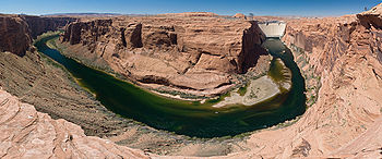
- The expedition wanted to travel south to the Colorado RiverColorado RiverThe Colorado River , is a river in the Southwestern United States and northwestern Mexico, approximately long, draining a part of the arid regions on the western slope of the Rocky Mountains. The watershed of the Colorado River covers in parts of seven U.S. states and two Mexican states...
but learned from 8 Native American men that although they were not far from the Colorado River it was unapproachable, surrounded by a great, deep canyon (the Grand CanyonGrand CanyonThe Grand Canyon is a steep-sided canyon carved by the Colorado River in the United States in the state of Arizona. It is largely contained within the Grand Canyon National Park, the 15th national park in the United States...
). Out of provisions, they sacrificed one of the horses for food and the next day made it their top priority to find water. Miera was ill, unable to eat and nearly unable to speak. Near Diamond Butte, they came upon five Native Americans, called Yubuincariris, who showed them to an area of good water and took a few men back to their village to trade for some food, wild sheep, prickly pear and grass seeds. The Native Americans also shared information about other neighboring tribes. Although they knew nothing of Monterey, they had heard of the travels of Father Garces.
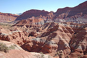
Paria River, near the Colorado River, October 22
- The expedition continued to experience difficulties due to illness and lack of water, pastureland and supplies as they made their way east across what is now the state of ArizonaArizonaArizona ; is a state located in the southwestern region of the United States. It is also part of the western United States and the mountain west. The capital and largest city is Phoenix...
, sometimes heading north enough to cross into what is now UtahUtahUtah is a state in the Western United States. It was the 45th state to join the Union, on January 4, 1896. Approximately 80% of Utah's 2,763,885 people live along the Wasatch Front, centering on Salt Lake City. This leaves vast expanses of the state nearly uninhabited, making the population the...
. Many stops were made along the Paria RiverParia RiverThe Paria River is a tributary of the Colorado River, approximately long, in southern Utah and northern Arizona in the United States. It drains a rugged and arid region northwest of the Colorado, flowing through roadless slot canyons along part of its course....
canyons and plateau, WahweapWahweap, Lake PowellWahweap is located at the southern end of Lake Powell in Arizona. Lake Powell, and all of its points of interest, is managed by the National Park Service and available to the public for recreational purposes.-Fish species:* Largemouth Bass...
and Glen CanyonGlen CanyonGlen Canyon is a canyon that is located in southeastern and south central Utah and northwestern Arizona within the Vermilion Cliffs area. It was carved by the Colorado River....
.
- The men returned to Santa Fe by way of Arizona, skirting the Grand CanyonGrand CanyonThe Grand Canyon is a steep-sided canyon carved by the Colorado River in the United States in the state of Arizona. It is largely contained within the Grand Canyon National Park, the 15th national park in the United States...
, and passing through the badlands of western New Mexico.
Old Spanish Trail
The maps and information provided from the expedition provided useful information for future travel and their route from Santa Fe to the Salt Lake Valley became known as the Old Spanish TrailOld Spanish Trail (trade route)
The Old Spanish Trail is a historical trade route which connected the northern New Mexico settlements near or in Santa Fe, New Mexico with that of Los Angeles, California and southern California. Approximately long, it ran through areas of high mountains, arid deserts, and deep canyons. It is...
.
Francisco Atanasio Domínguez
Fray Francisco Atanasio Domínguez was born about 1740, and at the age of 17 joined the Franciscan order in 1757. In October 1772, Domínguez was at the Convent of VeracruzVeracruz
Veracruz, formally Veracruz de Ignacio de la Llave officially Estado Libre y Soberano de Veracruz de Ignacio de la Llave , is one of the 31 states that, along with the Federal District, comprise the 32 federative entities of Mexico. It is divided in 212 municipalities and its capital city is...
as Commissary of the Third Order. He arrived in Sante Fe on March 22, 1776, in present day New Mexico, of the Mexican province to inspect the Custody of the Conversion of St. Paul and investigate opening an overland route from Santa Fe to Monterey, California. Upon Francisco Atanasio Domínguez's return to Santa Fe
Santa Fe, New Mexico
Santa Fe is the capital of the U.S. state of New Mexico. It is the fourth-largest city in the state and is the seat of . Santa Fe had a population of 67,947 in the 2010 census...
and Mexico City, Domínguez submitted to his Franciscan superiors a report that was highly critical of the administration of the 'New Mexico
New Mexico
New Mexico is a state located in the southwest and western regions of the United States. New Mexico is also usually considered one of the Mountain States. With a population density of 16 per square mile, New Mexico is the sixth-most sparsely inhabited U.S...
' missions. His views caused him to fall out of favor with the Franciscans in power, leading him to an assignment to an obscure post at a Sonoran Desert mission
Spanish missions in the Sonoran Desert
The Spanish missions in the Sonoran Desert are a series of Jesuit Catholic religious outposts established by the Spanish Catholic Jesuits and other orders for religious conversions of the Pima and Tohono O'odham indigenous peoples residing in the Sonoran Desert...
in the Sonora y Sinaloa Province
Sonora y Sinaloa
Sonora y Sinaloa was a province in the Provincias Internas and under the jurisdiction of the Real Audiencia of Guadalajara of Viceroyalty of New Spain. After Independence Sonora y Sinaloa became one of the constituent states of the Mexican Republic...
in northern Mexico.
In 1777 returned to Mexico and was the chaplain of presidios in Nueva Vizcaya. In 1800 he was at Janos, Sonora, Mexico. He died between 1803 and 1805.
Silvestre Vélez de Escalante
Silvestre Vélez de Escalante was born in Trecino, Spain about 1750. When he was 17 he became a Franciscan in the Convento Grande in Mexico City. In 1774 he came to present day New Mexico in the Mexican province; He was first stations at Laguna pueblow and then in January 1775 assigned as a minister to the Zuni. In June 1776 he was summoned by Domínguez for the expedition to California and remained in New Mexico for two years following the expedition. He died at the age of 30 in April 1780 in Parral, Mexico during his return journey to Mexico City for medical treatment.Silvestre Vélez de Escalante was known for his journal, in which he described the expeditions he went on. Escalante namesakes include Escalante Desert
Escalante Desert
The Escalante Desert is a geographic Great Basin region and arid desert ecoregion, in the Deserts and xeric shrublands Biome, located in southwestern Utah.-Geography:...
, Escalante River
Escalante River
right|Location of the Escalante River within UtahThe Escalante River is a tributary of the Colorado River. It is formed by the confluence of North and Birch Creeks near the town of Escalante in south-central Utah, and from there flows southeast for approximately before joining Lake Powell...
, Escalante (town)
Escalante, Utah
Escalante is a city in Garfield County, Utah, United States, along Utah Scenic Byway 12. As of the 2000 census, the city population was 818.The town was named after Silvestre Vélez de Escalante, a Franciscan missionary and the first European explorer in the region...
, Grand Staircase-Escalante National Monument
Grand Staircase-Escalante National Monument
The Grand Staircase-Escalante National Monument contains 1.9 million acres of land in southern Utah, the United States. There are three main regions: the Grand Staircase, the Kaiparowits Plateau, and the Canyons of the Escalante. President Bill Clinton designated the area as a U.S. National...
, and the Escalante Elementary
Escalante Elementary School
Escalante Elementary School is an elementary school that serves students in Kindergarten through sixth grade in the Rose Park neighborhood of Salt Lake City, Utah, Salt Lake City, Utah, United States, as part of the Salt Lake City School District...
& High schools (Rio Arriba County, New Mexico).
Don Bernardo Miera y Pacheco
Don Bernardo Miera y Pacheco, a native of Valle de Carriedo, Mantanas de Burgos, lived in Chihuahua before he moved to El Paso in 1743. From 1754-56 he lived in Santa Fe. Multi-talented, he was an army engineer, merchant, Indian fighter, government agent, rancher and artist. It was his experience as a cartographer that made the expedition historic when he published a map of the expedition in 1778 and a report on the expedition, which is included in Herbert E. Bolton, Pageant in the Wilderness: The Story of the Escalante Expedition to the Interior Basin. He is also known for his artwork, including a painting of St. Michael on an altar screen in Santa Fe’s chapel of San Miguel and statuettes that were in the Zuni church.Timpanog Utes
Fathers Dominguez and Escalante named three Timpanog tribe Ute Native Americans who joined the expedition as guides:- "Silvestre", named after Silvestre Escalante, from present day Utah was the main Native guide from Colorado to Utah. Because of his recognition with his and other Ute tribes, the explorers enjoyed safe passage.
- "Joaquin", a 12 year old boy, joined the expedition Silvestre as a guide. After leaving Silvestre's village, near present Provo, Utah, Joaquin assisted the explorers on their return trip to Santa Fe, New Mexico. He was baptized there in the Catholic Church.
- "Jose Maria", the joined name of the Bible's Joseph and Maria, joined the expedition in Silvestre's village. Like Juaquin, Jose Maria a boy, probably also about 12 years old. He did not complete the journey to Santa Fe; when he saw the terrible treatment of one of the servants, he returned to his village.
Other explorers
Other men who began the expedition in Santa Fe include:- Don Juan Pedro Cisneros, AlcaldeAlcaldeAlcalde , or Alcalde ordinario, is the traditional Spanish municipal magistrate, who had both judicial and administrative functions. An alcalde was, in the absence of a corregidor, the presiding officer of the Castilian cabildo and judge of first instance of a town...
mayor of Zuñi Pueblo - Don Joaquin Lain, a native of Santa Cruz in Castilla la Vieja and citizen of Sante Fe at the time of the expedition. He died in 1799.
- Lorenzo Olivares from La Villa del Paso, a citizen of El Paso a the time of the expedition
- Andrés Muñiz from Bernalillo, New Mexico served as an interpreter with the Utes language. He was part of Juan Maria de Rivera's expedition to the Gunnison River in 1775.
- Lucrecio Muñiz was the brother Andres Muniz, from Embudo, north of Santa Fe.
- Juan de Aguilar was born in Santa Clara, New Mexico.
- Simon Lucero, a servant to Don Pedro Cisneros, may have been Zuni.
See also
- History of New MexicoHistory of New MexicoEvidence from archaeologists conveys the existence of natives back to approximately 9200 BC. However, the history of New Mexico was not officially recorded until the arriving of the Conquistadors, who encountered Native American Pueblos when they explored the area in the 16th century...
Locations
- Dolores County, ColoradoDolores County, ColoradoDolores County is the seventh least populous of the 64 counties of the State of Colorado of the United States. The county population was 1,844 at U.S. Census 2000. The county seat is Dove Creek.- History :...
- Green River (Utah)Green River (Utah)The Green River, located in the western United States, is the chief tributary of the Colorado River. The watershed of the river, known as the Green River Basin, covers parts of Wyoming, Utah, and Colorado. The Green River is long, beginning in the Wind River Mountains of Wyoming and flowing...
- Padre BayPadre BayPadre Bay is part of Lake Powell in southern Utah.Located at mile 19 of Lake Powell, Padre Bay is the largest expanse of open water on the man made lake. Padre Bay is connected to Gunsight Butte and Cookie Jar Butte during high water periods...
- Spanish Fork, UtahSpanish Fork, UtahSpanish Fork is a city in Utah County, Utah, United States. It is part of the Provo–Orem, Utah Metropolitan Statistical Area. The population was 31,497 as of the 2008 census estimate.-History:Spanish Fork was settled by LDS pioneers in 1851...
Tribes
- Timpanog tribe
- Southern Paiute
- Ute Mountain Ute TribeUte Mountain Ute TribeThe Ute Mountain Ute Tribe is one of three federally recognized tribes of the Ute Nation, and are mostly descendants of the historic Weeminuche Band who moved to the Southern Ute reservation in 1897...