
Washoe Creek
Encyclopedia
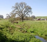
Washoe Creek 38.3499144°N 122.7330437°W is a perennial stream
located in Sonoma County, California
. It is about 2 mi (3 km) long and discharges to the Laguna de Santa Rosa
.
Washoe Creek rises in the low lying Meacham Hills southwest of the city of Cotati
. It descends to the northeast, flowing under Roblar Road and Stony Point Road. It then turns northward and parallels Stony Point Road, crossing under West Sierra Avenue and Madrone Avenue. Gravenstein Highway (State Route 116
) crosses the creek, which then enters an artificial channel. Gossage Creek enters from the west, and shortly thereafter the creek ends at a confluence with the Laguna de Santa Rosa just west of Rohnert Park
.
The original native riparian vegetation
was likely riparian woodland
, with Valley Oak
savanna
and grassland
on the upland east and west. The native habitat
s have been largely altered or replaced, due to the modern uses of grazing
, agriculture
, and urban development. In stream nitrate
concentrations are noticeably higher for Washoe Creek than other watercourse
s within the Laguna de Santa Rosa watershed
. The lower reach is under consideration for a restoration
project.
by the Coast Miwok
peoples, who built small villages along the banks of Washoe Creek and other local watercourses. These early peoples were gatherers and utilized resources of the creek as well as upland areas for subsistence. In 1833 this entire area around present Cotati was part of a Mexican
land grant
.
One of the area's American pioneers was Robert Ayres, who in 1859 built Washoe House
near the creek's headwaters.
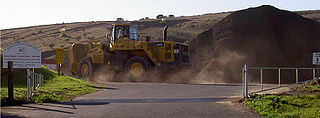 In the early 1900s, a rock quarry on Peterson Road (Gossage Creek watershed) was abandoned, and a new quarry was begun on Stony Point Road. The creek lies just across Stony Point Road from the current quarry site.
Perennial stream
A perennial stream or perennial river is a stream or river that has continuous flow in parts of its bed all year round during years of normal rainfall. "Perennial" streams are contrasted with "intermittent" streams which normally cease flowing for weeks or months each year, and with "ephemeral"...
located in Sonoma County, California
Sonoma County, California
Sonoma County, located on the northern coast of the U.S. state of California, is the largest and northernmost of the nine San Francisco Bay Area counties. Its population at the 2010 census was 483,878. Its largest city and county seat is Santa Rosa....
. It is about 2 mi (3 km) long and discharges to the Laguna de Santa Rosa
Laguna de Santa Rosa
The Laguna de Santa Rosa is a long wetland complex that drains a 254-square mile watershed encompassing most of the Santa Rosa Plain in Sonoma County, California, USA.-Description:...
.
Washoe Creek rises in the low lying Meacham Hills southwest of the city of Cotati
Cotati, California
Cotati is an incorporated city in Sonoma County, California, U.S.A., located about north of San Francisco in the 101 corridor between Rohnert Park and Petaluma....
. It descends to the northeast, flowing under Roblar Road and Stony Point Road. It then turns northward and parallels Stony Point Road, crossing under West Sierra Avenue and Madrone Avenue. Gravenstein Highway (State Route 116
California State Route 116
State Route 116 is a state highway in the U.S. state of California in Sonoma County. The route runs from State Route 1 on the Pacific coast near Jenner to State Route 121 south of Sonoma.-Route description:...
) crosses the creek, which then enters an artificial channel. Gossage Creek enters from the west, and shortly thereafter the creek ends at a confluence with the Laguna de Santa Rosa just west of Rohnert Park
Rohnert Park, California
Rohnert Park is a city in Sonoma County, California, United States, located approximately north of San Francisco. The population at the 2010 United States Census was 40,971. It is an early planned city, modeled directly after Levittown, New York and Levittown, Pennsylvania. Rohnert Park is the...
.
The original native riparian vegetation
Vegetation
Vegetation is a general term for the plant life of a region; it refers to the ground cover provided by plants. It is a general term, without specific reference to particular taxa, life forms, structure, spatial extent, or any other specific botanical or geographic characteristics. It is broader...
was likely riparian woodland
Woodland
Ecologically, a woodland is a low-density forest forming open habitats with plenty of sunlight and limited shade. Woodlands may support an understory of shrubs and herbaceous plants including grasses. Woodland may form a transition to shrubland under drier conditions or during early stages of...
, with Valley Oak
Valley Oak
Quercus lobata, commonly called the Valley oak, grows into the largest of North American oaks. It is endemic to California, growing in the interior valleys and foothills. Mature specimens may attain an age of up to 600 years. This deciduous oak requires year-round access to groundwater.Its thick,...
savanna
Savanna
A savanna, or savannah, is a grassland ecosystem characterized by the trees being sufficiently small or widely spaced so that the canopy does not close. The open canopy allows sufficient light to reach the ground to support an unbroken herbaceous layer consisting primarily of C4 grasses.Some...
and grassland
Grassland
Grasslands are areas where the vegetation is dominated by grasses and other herbaceous plants . However, sedge and rush families can also be found. Grasslands occur naturally on all continents except Antarctica...
on the upland east and west. The native habitat
Habitat
* Habitat , a place where a species lives and grows*Human habitat, a place where humans live, work or play** Space habitat, a space station intended as a permanent settlement...
s have been largely altered or replaced, due to the modern uses of grazing
Grazing
Grazing generally describes a type of feeding, in which a herbivore feeds on plants , and also on other multicellular autotrophs...
, agriculture
Agriculture
Agriculture is the cultivation of animals, plants, fungi and other life forms for food, fiber, and other products used to sustain life. Agriculture was the key implement in the rise of sedentary human civilization, whereby farming of domesticated species created food surpluses that nurtured the...
, and urban development. In stream nitrate
Nitrate
The nitrate ion is a polyatomic ion with the molecular formula NO and a molecular mass of 62.0049 g/mol. It is the conjugate base of nitric acid, consisting of one central nitrogen atom surrounded by three identically-bonded oxygen atoms in a trigonal planar arrangement. The nitrate ion carries a...
concentrations are noticeably higher for Washoe Creek than other watercourse
Watercourse
A watercourse is any flowing body of water. These include rivers, streams, anabranches, and so forth.-See also:* physical geography* Environmental flow* Waterway* Hydrology* Wadi-External links:...
s within the Laguna de Santa Rosa watershed
Drainage basin
A drainage basin is an extent or an area of land where surface water from rain and melting snow or ice converges to a single point, usually the exit of the basin, where the waters join another waterbody, such as a river, lake, reservoir, estuary, wetland, sea, or ocean...
. The lower reach is under consideration for a restoration
Restoration ecology
-Definition:Restoration ecology is the scientific study and practice of renewing and restoring degraded, damaged, or destroyed ecosystems and habitats in the environment by active human intervention and action, within a short time frame...
project.
History
This area was settled at least as early as 2000 BC20th century BC
The 20th century BC is a century which lasted from the year 2000 BC to 1901 BC.-Events:* 2000 BC: Arrival of the ancestors of the Latins in Italy.* 2000 BC: Town of Mantua was presumably founded.* 2000 BC: Stonehenge is believed to have been completed....
by the Coast Miwok
Coast Miwok
The Coast Miwok were the second largest group of Miwok Native American people. The Coast Miwok inhabited the general area of modern Marin County and southern Sonoma County in Northern California, from the Golden Gate north to Duncans Point and eastward to Sonoma Creek...
peoples, who built small villages along the banks of Washoe Creek and other local watercourses. These early peoples were gatherers and utilized resources of the creek as well as upland areas for subsistence. In 1833 this entire area around present Cotati was part of a Mexican
Mexico
The United Mexican States , commonly known as Mexico , is a federal constitutional republic in North America. It is bordered on the north by the United States; on the south and west by the Pacific Ocean; on the southeast by Guatemala, Belize, and the Caribbean Sea; and on the east by the Gulf of...
land grant
Land grant
A land grant is a gift of real estate – land or its privileges – made by a government or other authority as a reward for services to an individual, especially in return for military service...
.
One of the area's American pioneers was Robert Ayres, who in 1859 built Washoe House
Washoe House
Washoe House is a historic roadhouse in Sonoma County, California in the United States. It is located west of Cotati, California at the juncture of Stony Point Road and Roblar Road...
near the creek's headwaters.
See also
- Limnanthes vinculans
- List of watercourses in the San Francisco Bay Area
- QuarryQuarryA quarry is a type of open-pit mine from which rock or minerals are extracted. Quarries are generally used for extracting building materials, such as dimension stone, construction aggregate, riprap, sand, and gravel. They are often collocated with concrete and asphalt plants due to the requirement...
- Riparian zoneRiparian zoneA riparian zone or riparian area is the interface between land and a river or stream. Riparian is also the proper nomenclature for one of the fifteen terrestrial biomes of the earth. Plant habitats and communities along the river margins and banks are called riparian vegetation, characterized by...