
Washington State Route 902
Encyclopedia
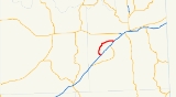
State Route 902 is a 12.36 miles (19.9 km) long state highway
located entirely in Spokane County
, Washington, United States. The highway serves to connect Lakeland Village and Medical Lake
to the county seat
of Spokane
. The highway has existed since at least 1931, and before the 1964 state highway renumbering
, it was numbered Secondary State Highway 11D. Between 1,600 and 9,200 vehicles used the highway on an average day in 2009.
, on the concurrent
Interstate 90
(I-90)/U.S. Route 395
(US 395) in western Spokane County
. The road travels northwesterly through sparsely populated light woodlands, passing west of a small lake, before turning north. The highway then passes Lakeland Village, a educational facility for the mentally disabled, before reaching the city of Medical Lake
. The highway passes through western Medical Lake and Medical Lake High School
before turning east at Brooks Road. The highway passes over a rail line belonging to the Eastern Washington Gateway railroad, before leaving Medical Lake city limits. The road continues northeast, clipping the southern border of Fairchild Air Force Base
before intersecting the concurrent I-90/US 395 at exit 272.
Every year, Washington State Department of Transportation
(WSDOT) conducts a series of surveys on its highways in the state to measure traffic volume. This is expressed in terms of average annual daily traffic (AADT), which is a measure of traffic volume for any average day of the year. In 2009, WSDOT calculated that as few as 1,600 vehicles used the highway at the western terminus, and as many as 9,200 vehicles at the eastern terminus.
Before the 1964 state highway renumbering
, SR 902 was numbered Secondary State Highway 11D, a branch of Primary State Highway 11, the predecessor to US 395 through the region. No changes have been made to the alignment of the roadway, however the legal definition of the highway was changed during the 1991 legislative session.
.
{| class="wikitable"
|-
!scope=col|Mile
!scope=col|Destinations
!scope=col|Notes
|-
|0.00–0.11
|
|Interchange
, western terminus
|-
|12.17–12.36
|
|Interchange, eastern terminus
State highway
State highway, state road or state route can refer to one of three related concepts, two of them related to a state or provincial government in a country that is divided into states or provinces :#A...
located entirely in Spokane County
Spokane County, Washington
Spokane County is a county located in the U.S. state of Washington, named after the Spokane tribe. As of the 2010 census the population was 471,221, making it the fourth most populous county in Washington state. The largest city and county seat is Spokane, the second largest city in the state,...
, Washington, United States. The highway serves to connect Lakeland Village and Medical Lake
Medical Lake, Washington
Medical Lake is a city in Spokane County, Washington, United States. The population was 5,060 at the 2010 census. It is home to two mental hospitals, Eastern State Hospital and Lakeland Village.-Geography:...
to the county seat
County seat
A county seat is an administrative center, or seat of government, for a county or civil parish. The term is primarily used in the United States....
of Spokane
Spokane, Washington
Spokane is a city located in the Northwestern United States in the state of Washington. It is the largest city of Spokane County of which it is also the county seat, and the metropolitan center of the Inland Northwest region...
. The highway has existed since at least 1931, and before the 1964 state highway renumbering
1964 state highway renumbering (Washington)
In 1963, a law was passed authorizing a new numbering for sign routes. In 1970 the legislative definitions were changed to use the sign route numbers but renamed state routes...
, it was numbered Secondary State Highway 11D. Between 1,600 and 9,200 vehicles used the highway on an average day in 2009.
Route description
SR 902 begins at exit 264, a diamond interchangeDiamond interchange
A diamond interchange is a common type of road junction, used where a freeway crosses a minor road. The freeway itself is grade-separated from the minor road, one crossing the other over a bridge...
, on the concurrent
Concurrency (road)
A concurrency, overlap, or coincidence in a road network is an instance of one physical road bearing two or more different highway, motorway, or other route numbers...
Interstate 90
Interstate 90 in Washington
Interstate 90 , a transcontinental Interstate Highway from Seattle, Washington, to Boston, Massachusetts, crosses the state of Washington before crossing the Idaho state line between Spokane and Post Falls...
(I-90)/U.S. Route 395
U.S. Route 395 in Washington
In the U.S. state of Washington, U.S. Route 395 is a major state highway in two parts, separated by a long overlap with Interstate 90 between Ritzville and Spokane. The southern piece, from I-82 near the Tri-Cities to I-90 near Ritzville, is a high-speed four-lane divided highway...
(US 395) in western Spokane County
Spokane County, Washington
Spokane County is a county located in the U.S. state of Washington, named after the Spokane tribe. As of the 2010 census the population was 471,221, making it the fourth most populous county in Washington state. The largest city and county seat is Spokane, the second largest city in the state,...
. The road travels northwesterly through sparsely populated light woodlands, passing west of a small lake, before turning north. The highway then passes Lakeland Village, a educational facility for the mentally disabled, before reaching the city of Medical Lake
Medical Lake, Washington
Medical Lake is a city in Spokane County, Washington, United States. The population was 5,060 at the 2010 census. It is home to two mental hospitals, Eastern State Hospital and Lakeland Village.-Geography:...
. The highway passes through western Medical Lake and Medical Lake High School
Medical Lake High School
Medical Lake High School is located in Medical Lake, Washington. The school mascot is the cardinals.- Location :This city of Medical Lake is a city in Spokane County, Washington, United States. The population was 4,358 people at the 2000 census...
before turning east at Brooks Road. The highway passes over a rail line belonging to the Eastern Washington Gateway railroad, before leaving Medical Lake city limits. The road continues northeast, clipping the southern border of Fairchild Air Force Base
Fairchild Air Force Base
Fairchild Air Force Base is a United States Air Force base located approximately southwest of Spokane, Washington.The host unit at Fairchild is the 92d Air Refueling Wing assigned to the Air Mobility Command's 15th Expeditionary Mobility Task Force...
before intersecting the concurrent I-90/US 395 at exit 272.
Every year, Washington State Department of Transportation
Washington State Department of Transportation
The Washington State Department of Transportation , was established in 1905. The agency, led by a Secretary and overseen by the Governor, is a Washington governmental agency that constructs, maintains, and regulates the use of the state's transportation infrastructure...
(WSDOT) conducts a series of surveys on its highways in the state to measure traffic volume. This is expressed in terms of average annual daily traffic (AADT), which is a measure of traffic volume for any average day of the year. In 2009, WSDOT calculated that as few as 1,600 vehicles used the highway at the western terminus, and as many as 9,200 vehicles at the eastern terminus.
History
The first roadway linking now I-90/US 395 and Medical Lake first appeared on maps in 1931. By the 1933 map, the remainder of the highway was present, linking back to I-90/US 395.Before the 1964 state highway renumbering
1964 state highway renumbering (Washington)
In 1963, a law was passed authorizing a new numbering for sign routes. In 1970 the legislative definitions were changed to use the sign route numbers but renamed state routes...
, SR 902 was numbered Secondary State Highway 11D, a branch of Primary State Highway 11, the predecessor to US 395 through the region. No changes have been made to the alignment of the roadway, however the legal definition of the highway was changed during the 1991 legislative session.
Major intersections
The entire route is located in Spokane CountySpokane County, Washington
Spokane County is a county located in the U.S. state of Washington, named after the Spokane tribe. As of the 2010 census the population was 471,221, making it the fourth most populous county in Washington state. The largest city and county seat is Spokane, the second largest city in the state,...
.
{| class="wikitable"
|-
!scope=col|Mile
!scope=col|Destinations
!scope=col|Notes
|-
|0.00–0.11
|
|Interchange
Interchange (road)
In the field of road transport, an interchange is a road junction that typically uses grade separation, and one or more ramps, to permit traffic on at least one highway to pass through the junction without directly crossing any other traffic stream. It differs from a standard intersection, at which...
, western terminus
|-
|12.17–12.36
|
|Interchange, eastern terminus