

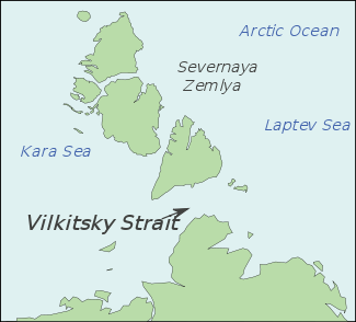
Vilkitsky Strait
Encyclopedia
- For other geographic features called "Vilkitsky" see Vilkitsky (disambiguation).
Vilkitsky Strait is a strait
Strait
A strait or straits is a narrow, typically navigable channel of water that connects two larger, navigable bodies of water. It most commonly refers to a channel of water that lies between two land masses, but it may also refer to a navigable channel through a body of water that is otherwise not...
between the Taimyr Peninsula and Bolshevik Island
Bolshevik Island
Bolshevik Island is the southernmost island of the Severnaya Zemlya group in the Russian Arctic, and the second largest island in the group...
in the Severnaya Zemlya
Severnaya Zemlya
Severnaya Zemlya is an archipelago in the Russian high Arctic at around . It is located off mainland Siberia's Taymyr Peninsula across the Vilkitsky Strait...
archipelago. The strait connects the Kara
Kara Sea
The Kara Sea is part of the Arctic Ocean north of Siberia. It is separated from the Barents Sea to the west by the Kara Strait and Novaya Zemlya, and the Laptev Sea to the east by the Severnaya Zemlya....
and Laptev Sea
Laptev Sea
The Laptev Sea is a marginal sea of the Arctic Ocean. It is located between the northern coast of Siberia, the Taimyr Peninsula, Severnaya Zemlya and the New Siberian Islands. Its northern boundary passes from the Arctic Cape to a point with co-ordinates of 79°N and 139°E, and ends at the Anisiy...
s. The length of the Vilkitsky Strait is 104 km
KM
KM, Km, or km may stand for:*Kilometre *Kernel methods*Kettle Moraine High School*Khmer language *Kuomintang , a centre-right political party in the Republic of China on Taiwan...
, the width – approx. 55 km, and the depth – between 32 and 210 m
M
M is the thirteenth letter of the basic modern Latin alphabet.-History:The letter M is derived from the Phoenician Mem, via the Greek Mu . Semitic Mem probably originally pictured water...
. It is covered with drifting ice during winter. The strait was discovered in 1913 by a Russia
Russia
Russia or , officially known as both Russia and the Russian Federation , is a country in northern Eurasia. It is a federal semi-presidential republic, comprising 83 federal subjects...
n hydrographic
Hydrography
Hydrography is the measurement of the depths, the tides and currents of a body of water and establishment of the sea, river or lake bed topography and morphology. Normally and historically for the purpose of charting a body of water for the safe navigation of shipping...
expedition led by Boris Vilkitsky
Boris Vilkitsky
Boris Andreyevich Vilkitsky was a Russian hydrographer and surveyor. He was the son of Andrey Ippolitovich Vilkitsky....
and then named after him in 1918.
The Vilkitsky Strait is the northernmost strait in Russia
Russia
Russia or , officially known as both Russia and the Russian Federation , is a country in northern Eurasia. It is a federal semi-presidential republic, comprising 83 federal subjects...
's Northern Sea Route
Northern Sea Route
The Northern Sea Route is a shipping lane officially defined by Russian legislation from the Atlantic Ocean to the Pacific Ocean specifically running along the Russian Arctic coast from Murmansk on the Barents Sea, along Siberia, to the Bering Strait and Far East. The entire route lies in Arctic...
.
The Geiberg Islands
Geiberg Islands
The Heiberg Islands, spelt Geyberg, Gejberg or Geiberg is a group of four small islands covered with tundra vegetation and with scattered stones on their shores. They lie in the Kara Sea, between the bleak coast of Siberia's Taymyr Peninsula and Severnaya Zemlya...
are covering the entrance to the Vilkitski Strait from the east and the Firnley Islands
Firnley Islands
The Firnley Islands, also spelt Firnleya or Firileya is a group of three small islands covered with tundra vegetation and with scattered stones on their shores. They lie in the Kara Sea, close to the bleak coast of Siberia's Taymyr Peninsula, not far east of the Nordenskjold Archipelago...
are doing so from the west. The shores on the side of the Taymyr Peninsula
Taymyr Peninsula
The Taymyr Peninsula is a peninsula in the Far North of Russia, in the Siberian Federal District, that forms the northernmost part of mainland Eurasia and Asia...
are covered with tundra vegetation and scattered stones. The northern coast is higher and it becomes lower going south. The rivers that are flowing into the Vilkitsky Strait from the continental side are not significant. They are shallow and unsuitable for navigation.