

Vale of Kent
Encyclopedia
The Vale of Kent, located in Kent
, England
, is the name given to the broad clay vale
between the Greensand Ridge
and the High Weald
. The area is drained by a number of rivers
, including the Beult
, Eden
Medway
, Stour
and River Teise
.
Principal settlements in the Vale include Ashford
and Tonbridge
.
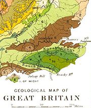
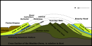 The Weald is the eroded remains of a geological structure, an anticline
, a dome of layered Lower Cretaceous rock
s cut through by weathering
to expose the layers as sandstone
ridges and clay
valleys. The oldest rocks exposed at the centre of the anticline are correlated with the Purbeck Beds of the Upper Jurassic. Above these, the Cretaceous rocks, include the Wealden Group
of alternating sands and clays - the Ashdown Sand, Wadhurst Clay, Tunbridge Wells Sand (collectively known as the Hastings Beds) and the Weald Clay. The Wealden Group is overlain by the Lower Greensand and the Gault Formation, consisting of the Gault Clay
and the Upper Greensand.
The rocks of the central part of the anticline include hard sandstones, and these form hills now called the High Weald. The peripheral areas are mostly of softer sandstones and clays and these form the gentler rolling landscapeof Low Weald, of which the Vale of Kent is a part. The Weald-Artois Anticline
continues some 65 km (40.4 mi) further south-eastwards under the Straits of Dover, and includes the Boulonnais
of France
.
Kent
Kent is a county in southeast England, and is one of the home counties. It borders East Sussex, Surrey and Greater London and has a defined boundary with Essex in the middle of the Thames Estuary. The ceremonial county boundaries of Kent include the shire county of Kent and the unitary borough of...
, England
England
England is a country that is part of the United Kingdom. It shares land borders with Scotland to the north and Wales to the west; the Irish Sea is to the north west, the Celtic Sea to the south west, with the North Sea to the east and the English Channel to the south separating it from continental...
, is the name given to the broad clay vale
River Valley
River Valley is the name of an urban planning area within the Central Area, Singapore's central business district.The River Valley Planning Area is defined by the region bounded by Orchard Boulevard, Devonshire Road and Eber Road to the north, Oxley Rise and Mohamed Sultan Road to the east, Martin...
between the Greensand Ridge
Greensand Ridge
The Greensand Ridge is an extensive, prominent, often heavily wooded, sandstone escarpment and range of hills in south-east England. It runs in a horseshoe shape around the Weald of Surrey, Sussex and Kent. It reaches its highest elevation, , at Leith Hill in Surrey—the second highest point...
and the High Weald
Weald
The Weald is the name given to an area in South East England situated between the parallel chalk escarpments of the North and the South Downs. It should be regarded as three separate parts: the sandstone "High Weald" in the centre; the clay "Low Weald" periphery; and the Greensand Ridge which...
. The area is drained by a number of rivers
Rivers of Kent
There are four rivers draining the county of Kent, England.- River Medway :This is the main river, whose catchment area covers almost 25% of the county...
, including the Beult
River Beult
The River Beult is a tributary of the River Medway. It has several sources west of Ashford, including one at Woodchurch. It then flows through Headcorn. At Hunton, above Yalding it is joined by the major stream of the River Teise. Town bridge lies 10¼ miles from Allington, it is the longest...
, Eden
River Eden, Kent
The River Eden in West Kent is a tributary of the River Medway. It travels through the Weald of Kent from the border with Surrey, rising from the source in Titsey parish, Surrey, grid reference TQ 420 551, about 350 metres north of Clacket Lane motorway services, and flowing...
Medway
River Medway
The River Medway, which is almost entirely in Kent, England, flows for from just inside the West Sussex border to the point where it enters the Thames Estuary....
, Stour
River Stour, Kent
The River Stour is the river in Kent, England that flows into the English Channel at Pegwell Bay. Above Plucks Gutter, where the Little Stour joins it, the river is normally known as the Great Stour. The upper section of the river, above its confluence with the East Stour at Ashford is sometimes...
and River Teise
River Teise
The River Teise is a tributary of the River Medway in Kent, England. It begins in Dunorlan Park in Tunbridge Wells. and flows eastwards past Bayham Abbey and then through Lamberhurst...
.
Principal settlements in the Vale include Ashford
Ashford, Kent
Ashford is a town in the borough of Ashford in Kent, England. In 2005 it was voted the fourth best place to live in the United Kingdom. It lies on the Great Stour river, the M20 motorway, and the South Eastern Main Line and High Speed 1 railways. Its agricultural market is one of the most...
and Tonbridge
Tonbridge
Tonbridge is a market town in the English county of Kent, with a population of 30,340 in 2007. It is located on the River Medway, approximately 4 miles north of Tunbridge Wells, 12 miles south west of Maidstone and 29 miles south east of London...
.
Geology
Anticline
In structural geology, an anticline is a fold that is convex up and has its oldest beds at its core. The term is not to be confused with antiform, which is a purely descriptive term for any fold that is convex up. Therefore if age relationships In structural geology, an anticline is a fold that is...
, a dome of layered Lower Cretaceous rock
Rock (geology)
In geology, rock or stone is a naturally occurring solid aggregate of minerals and/or mineraloids.The Earth's outer solid layer, the lithosphere, is made of rock. In general rocks are of three types, namely, igneous, sedimentary, and metamorphic...
s cut through by weathering
Weathering
Weathering is the breaking down of rocks, soils and minerals as well as artificial materials through contact with the Earth's atmosphere, biota and waters...
to expose the layers as sandstone
Sandstone
Sandstone is a sedimentary rock composed mainly of sand-sized minerals or rock grains.Most sandstone is composed of quartz and/or feldspar because these are the most common minerals in the Earth's crust. Like sand, sandstone may be any colour, but the most common colours are tan, brown, yellow,...
ridges and clay
Clay
Clay is a general term including many combinations of one or more clay minerals with traces of metal oxides and organic matter. Geologic clay deposits are mostly composed of phyllosilicate minerals containing variable amounts of water trapped in the mineral structure.- Formation :Clay minerals...
valleys. The oldest rocks exposed at the centre of the anticline are correlated with the Purbeck Beds of the Upper Jurassic. Above these, the Cretaceous rocks, include the Wealden Group
Wealden Group
The Wealden Group is a group in the lithostratigraphy of southern England. The Wealden group consists of paralic to continental facies sedimentary rocks of Valanginian to Barremian age and thus forms part of the English Lower Cretaceous. It is composed of alternating sands and clays...
of alternating sands and clays - the Ashdown Sand, Wadhurst Clay, Tunbridge Wells Sand (collectively known as the Hastings Beds) and the Weald Clay. The Wealden Group is overlain by the Lower Greensand and the Gault Formation, consisting of the Gault Clay
Gault Clay
Gault is a clay formation of stiff blue clay deposited in a calm, fairly deep water marine environment during the Lower Cretaceous Period...
and the Upper Greensand.
The rocks of the central part of the anticline include hard sandstones, and these form hills now called the High Weald. The peripheral areas are mostly of softer sandstones and clays and these form the gentler rolling landscapeof Low Weald, of which the Vale of Kent is a part. The Weald-Artois Anticline
Weald-Artois Anticline
The Weald–Artois anticline is a large anticline, a geological structure running between the regions of the Weald in southern England and the Artois in northeastern France. The fold formed during the Alpine orogeny, from the late Oligocene to middle Miocene as an uplifted form of the Weald basin...
continues some 65 km (40.4 mi) further south-eastwards under the Straits of Dover, and includes the Boulonnais
Boulonnais (land area)
The Boulonnais is a coastal area of northern France, around Calais and Boulogne-sur-Mer. It has a curved belt of chalk downs which run into the sea at both ends, and geologically is the east end of the Weald-Artois Anticline.- Administration :...
of France
France
The French Republic , The French Republic , The French Republic , (commonly known as France , is a unitary semi-presidential republic in Western Europe with several overseas territories and islands located on other continents and in the Indian, Pacific, and Atlantic oceans. Metropolitan France...
.