
Umnak
Encyclopedia
Umnak is one of the Fox Islands
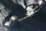
of the Aleutian Islands. With 686.01 square miles (1,776.76 km²) of land area, it is the third largest island in the Aleutian archipelago and the 19th largest island in the United States. The island is home to a large volcanic caldera
on Mount Okmok
and is separated from Unalaska Island
by Umnak Pass. In 2000, Umnak was permanently inhabited by only 39 people.
period, about 8250 to 3000 years ago, which led to a greater natural food supply on the island for the settlers.
The modern history of Umnak Island is linked to the defense bases established by the United States during World War II
. The purpose of these forward air bases in the Aleutian Islands was not only to defend the Dutch Harbor but also launch attacks against the Japanese.
The US Navy considered this island as exclusive and as "their turf". They created a camouflage of establishing "Blair Fish Packing Co," to build airports, as forward bases, for use by the US Army Air Force during World War II. General Buckner after getting clearance from General DeWitt, built the airbases at Umnak and at Cold Bay. With this, the garrison at Umnak had a strength of 4000, including engineering forces complemented by infantry and of field and antiaircraft artillery units, by the time the Japan
ese army enemy forces launched an attack two months later in the summer of 1942. The Japanese had been planning to attack this island in June and capture the island with the intention of maintaining an aerial patrol of North Pacific waters. The island was planned to become an outpost in a new area of dominance that would later include the Samoa
n and Fiji
Islands and New Caledonia
. The Japanese were unaware of the covert preparations being made by the United States as they believed that the island was only protected by a few ships operating in Aleutian waters.
and Unalaska, lies in the Fox Islands
of the Aleutian Islands of the Bering Sea
, to the southwest of the larger island of Unalaska. It is approximately 70–72 mi (112.7–115.9 km) in length (117 kilometres (72.7 mi)) and 16 miles (25.7 km) wide on average. The island was separated in the last Ice age
and now lies about 300 kilometres (186.4 mi) from North American shores. It is an active volcanic island, with a land area of 1793.2 square kilometre and with a coast line extending over 330.2 kilometres (205.2 mi). The elevation of the island is 2132 metres (6,994.8 ft). The island is very mountainous with a low level of vegetation. The island does not have a harbor, although a sizeable bay is located in western part of the island and contains the Adugak Island
. The southern point of the island is known as Cape Sagak.
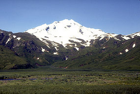
 The highest peak of the island, the Mount Vsevidof
stratovolcano
, is located in the southwestern part of the island. Its symmetrical cone rises abruptly from its surroundings and forms a 1.2 kilometre (0.745647283979768 mi) wide crater at a height of 2149 metres (7,050.5 ft). Its most recent eruption was caused by an earthquake on March 9, 1957. The mountain erupted on March 11, 1957, and the eruption ended the next day. To the east of Mount Vsevidof is the Russian Bay valley and another stratovolcano, Mount Recheshnoi
which is also deeply dissected with a height of 1984 metres (6,509.2 ft). In the southwest is the settlement of Nikolski
further south and a lake, Umnak Lake, to its southeast which is just over 2 kilometres (1.2 mi) in length. The ancient settlement of Chaluka is located between this lake and Nikolski. This area is known as the Samalga Pass and was the center of ancient activity on the island and is located about 15 miles (24.1 km) off the southwestern tip of the island (Cape Sagak).
 The north-northeastern part of the island contains tholeittic basaltic rocks and is characterized by tension faulting, lava flows and fragmental deposits of igneous rocks. The volcano of Mount Okmok
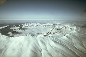
, characterized by its 5.8 miles (9.3 km) wide circular caldera
, it located in the northwestern part of the island. This generally flat central basin has an average elevation of 370 m above sea level, with the rim of the caldera reaching a height of 1073 metres (3,520.3 ft). Following the formation of the caldera, numerous satellite cones and lava dome
s have formed on the flanks of the volcano. They include Mount Tulik (1253 metres (4,111 ft)) on the caldera's southeastern slope, Mount Idak (585 metres (1,919 ft)) to the northeast, and Jag Peak. A crater lake
once filled much of the caldera to a depth of over 500 feet (152.4 m), but the lake ultimately drained through a notch eroded in the northeast rim. The prehistoric lake attained a maximum depth of about 150 metres (492.1 ft) and the upper surface reached an elevation of about 475 metres (1,558.4 ft), at which point it over topped the low point of the caldera rim. Small, shallow remnants of the lake remained north of Cone D at an altitude of about 1075 feet (327.7 m): a small shallow lake located between the caldera rim and Cone D; a smaller lake (named Cone B Lake) farther north near the caldera's gate. After the 2008 eruption, the hydrogeology
of the caldera was greatly changed with five separate sizable lakes now emplaced. In addition to the caldera lakes, Cone A, Cone E, Cone G and the new 2008 vent on Cone D contain small crater lakes. The volcano is currently rated by the Alaska Volcano Observatory
as Aviation Alert Level
Green and Volcanic-alert Level
Normal.
ns. , the island's population further declined to 39 persons. Its only remaining community, Nikolski
, comprised the island's entire population. Fort Glenn, a former major military facility on the northeast shore of the island, played an instrumental role in the North Pacific Theater
in World War II
.
, there were 15 households and 12 families residing on the island. The population density
was 0.3 PD/sqmi. There were 28 housing units at an average density of 0.2 /sqmi. The racial makeup of was 30.77% White
and 69.23% Native American
.
There were 15 households out of which 40.0% had children under the age of 18 living with them, 53.3% were married couples
living together, 20.0% had a female householder with no husband present, and 20.0% were non-families. 20.0% of all households were made up of individuals and none had someone living alone who was 65 years of age or older. The average household size was 2.60 and the average family size was 2.92.
In 2000, the median age was 40 years, with 35.9% under the age of 18, 30.8% from 25 to 44, 23.1% from 45 to 64, and 10.3% who were 65 years of age or older. For every 100 females there were 105.3 males. For every 100 females of age 18 and over, there were 92.3 males.
The median income for a household was $38,750, and the median income for a family was $40,250. Males had a median income of $26,250 versus $11,875 for females. The per capita income
was $14,083. There were 23.5% of families and 20.7% of the population living below the poverty line, including 13.6% of under eighteens and 55.6% of those over 64.
, located on Umnak, erupted for several days, through a fresh vent sending wet, ash and gas-rich plume that reached an altitude of 50000 feet (15,240 m) in the air and forcing the evacuation of Fort Glenn, a private cattle ranch located on the island. Ash fell not only on the eastern part of the island but also on a fishing village 65 miles (104.6 km) on the northeast. However, the Aleut village, Nikolski, on the opposite side of Umnak Island with a population of about 40 people to the west of Okmok Volcano escaped from the southeasterly path of the ash clouds. The ash plume also disrupted operation of flights to the Dutch Harbor airport as it spread across many miles of the North Pacific.
Okmok Caldera itself had been formed and reshaped in two major eruptions which occurred 12,000 and 2,000 years ago. Direct observations of later volcanic activity are known since 1805, with 16 eruptions recorded every 10 to 20 years. The 1817 eruption deposited several feet of ash and "scoria" rock debris on the northeastern caldera rim, with ash falling on Unalaska Island. Floods that occurred during this destroyed an Aleut village at Cape Tanak on the northeast Bering Sea Coast of the island. In the recent 1997 eruption, the ash clouds traveled 6 miles (9.7 km) across the volcano's caldera floor.
's P-40 fighter aircraft to land.
Fox Islands (Alaska)
The Fox Islands are a group of islands in the eastern Aleutian Islands of the U.S. state of Alaska. The Fox Islands are the closest to mainland North America in the Aleutian chain, and just east of Samalga Pass and the Islands of Four Mountains group....
of the Aleutian Islands. With 686.01 square miles (1,776.76 km²) of land area, it is the third largest island in the Aleutian archipelago and the 19th largest island in the United States. The island is home to a large volcanic caldera
Caldera
A caldera is a cauldron-like volcanic feature usually formed by the collapse of land following a volcanic eruption, such as the one at Yellowstone National Park in the US. They are sometimes confused with volcanic craters...
on Mount Okmok
Mount Okmok
Mount Okmok is the highest point on the rim of Okmok Caldera on the northeastern part of Umnak Island in the eastern Aleutian Islands of Alaska, USA. This 5.8 mile wide circular caldera truncates the top of a large shield volcano...
and is separated from Unalaska Island
Unalaska Island
Unalaska is an island in the Fox Islands group of the Aleutian Islands in the U.S. state of Alaska, at . The island has a land area of . The city of Unalaska, Alaska, covers part of the island and all of neighboring Amaknak Island where the Port of Dutch Harbor is located...
by Umnak Pass. In 2000, Umnak was permanently inhabited by only 39 people.
History
The earliest known settlement on Umnak Island is at Anangula and is 8400 years old. Anangula was later abandoned and the Sandy Beach site became occupied, along with Idaliuk and Chaluka. Most of the early settlements that grew up on Umnak were located along the streams. A major geologic event was the cutting of strand flats during the HypsithermalHolocene climatic optimum
The Holocene Climate Optimum was a warm period during roughly the interval 9,000 to 5,000 years B.P.. This event has also been known by many other names, including: Hypsithermal, Altithermal, Climatic Optimum, Holocene Optimum, Holocene Thermal Maximum, and Holocene Megathermal.This warm period...
period, about 8250 to 3000 years ago, which led to a greater natural food supply on the island for the settlers.
The modern history of Umnak Island is linked to the defense bases established by the United States during World War II
World War II
World War II, or the Second World War , was a global conflict lasting from 1939 to 1945, involving most of the world's nations—including all of the great powers—eventually forming two opposing military alliances: the Allies and the Axis...
. The purpose of these forward air bases in the Aleutian Islands was not only to defend the Dutch Harbor but also launch attacks against the Japanese.
The US Navy considered this island as exclusive and as "their turf". They created a camouflage of establishing "Blair Fish Packing Co," to build airports, as forward bases, for use by the US Army Air Force during World War II. General Buckner after getting clearance from General DeWitt, built the airbases at Umnak and at Cold Bay. With this, the garrison at Umnak had a strength of 4000, including engineering forces complemented by infantry and of field and antiaircraft artillery units, by the time the Japan
Japan
Japan is an island nation in East Asia. Located in the Pacific Ocean, it lies to the east of the Sea of Japan, China, North Korea, South Korea and Russia, stretching from the Sea of Okhotsk in the north to the East China Sea and Taiwan in the south...
ese army enemy forces launched an attack two months later in the summer of 1942. The Japanese had been planning to attack this island in June and capture the island with the intention of maintaining an aerial patrol of North Pacific waters. The island was planned to become an outpost in a new area of dominance that would later include the Samoa
Samoa
Samoa , officially the Independent State of Samoa, formerly known as Western Samoa is a country encompassing the western part of the Samoan Islands in the South Pacific Ocean. It became independent from New Zealand in 1962. The two main islands of Samoa are Upolu and one of the biggest islands in...
n and Fiji
Fiji
Fiji , officially the Republic of Fiji , is an island nation in Melanesia in the South Pacific Ocean about northeast of New Zealand's North Island...
Islands and New Caledonia
New Caledonia
New Caledonia is a special collectivity of France located in the southwest Pacific Ocean, east of Australia and about from Metropolitan France. The archipelago, part of the Melanesia subregion, includes the main island of Grande Terre, the Loyalty Islands, the Belep archipelago, the Isle of...
. The Japanese were unaware of the covert preparations being made by the United States as they believed that the island was only protected by a few ships operating in Aleutian waters.
Geography
Umnak, the third largest of the Aleutian Islands after UnimakUnimak
Unimak may refer to:Geography*Unimak Island, largest of the Aleutian Islands*Unimak Bay on the coast of Unimak Island*Unimak Pass, a passage between the Bering Sea and North Pacific OceanShips...
and Unalaska, lies in the Fox Islands
Fox Islands (Alaska)
The Fox Islands are a group of islands in the eastern Aleutian Islands of the U.S. state of Alaska. The Fox Islands are the closest to mainland North America in the Aleutian chain, and just east of Samalga Pass and the Islands of Four Mountains group....
of the Aleutian Islands of the Bering Sea
Bering Sea
The Bering Sea is a marginal sea of the Pacific Ocean. It comprises a deep water basin, which then rises through a narrow slope into the shallower water above the continental shelves....
, to the southwest of the larger island of Unalaska. It is approximately 70–72 mi (112.7–115.9 km) in length (117 kilometres (72.7 mi)) and 16 miles (25.7 km) wide on average. The island was separated in the last Ice age
Ice age
An ice age or, more precisely, glacial age, is a generic geological period of long-term reduction in the temperature of the Earth's surface and atmosphere, resulting in the presence or expansion of continental ice sheets, polar ice sheets and alpine glaciers...
and now lies about 300 kilometres (186.4 mi) from North American shores. It is an active volcanic island, with a land area of 1793.2 square kilometre and with a coast line extending over 330.2 kilometres (205.2 mi). The elevation of the island is 2132 metres (6,994.8 ft). The island is very mountainous with a low level of vegetation. The island does not have a harbor, although a sizeable bay is located in western part of the island and contains the Adugak Island
Adugak Island
Adugak Island is a small island in the Fox Islands group in the Aleutian Islands of southwestern Alaska. It is about long and is located off the northwest coast of Umnak Island...
. The southern point of the island is known as Cape Sagak.
Mount Vsevidof
Mount Vsevidof is a stratovolcano in the U.S. state of Alaska. Its summit is the highest point on Umnak Island, one of the eastern Aleutian Islands. Its symmetrical cone rises abruptly from its surroundings. Its most recent eruption was caused by an earthquake on March 9, 1957...
stratovolcano
Stratovolcano
A stratovolcano, also known as a composite volcano, is a tall, conical volcano built up by many layers of hardened lava, tephra, pumice, and volcanic ash. Unlike shield volcanoes, stratovolcanoes are characterized by a steep profile and periodic, explosive eruptions...
, is located in the southwestern part of the island. Its symmetrical cone rises abruptly from its surroundings and forms a 1.2 kilometre (0.745647283979768 mi) wide crater at a height of 2149 metres (7,050.5 ft). Its most recent eruption was caused by an earthquake on March 9, 1957. The mountain erupted on March 11, 1957, and the eruption ended the next day. To the east of Mount Vsevidof is the Russian Bay valley and another stratovolcano, Mount Recheshnoi
Mount Recheshnoi
Mount Recheshnoi is a heavily eroded stratovolcano located near the center of the SW lobe of Umnak Island in the Aleutian Islands of Alaska....
which is also deeply dissected with a height of 1984 metres (6,509.2 ft). In the southwest is the settlement of Nikolski
Nikolski, Alaska
Nikolski is a census-designated place on Umnak Island in Aleutians West Census Area, Alaska, United States. The population was 39 at the 2000 census.-Geography:Nikolski is located at .According to the U.S...
further south and a lake, Umnak Lake, to its southeast which is just over 2 kilometres (1.2 mi) in length. The ancient settlement of Chaluka is located between this lake and Nikolski. This area is known as the Samalga Pass and was the center of ancient activity on the island and is located about 15 miles (24.1 km) off the southwestern tip of the island (Cape Sagak).
Mount Okmok
Mount Okmok is the highest point on the rim of Okmok Caldera on the northeastern part of Umnak Island in the eastern Aleutian Islands of Alaska, USA. This 5.8 mile wide circular caldera truncates the top of a large shield volcano...
, characterized by its 5.8 miles (9.3 km) wide circular caldera
Caldera
A caldera is a cauldron-like volcanic feature usually formed by the collapse of land following a volcanic eruption, such as the one at Yellowstone National Park in the US. They are sometimes confused with volcanic craters...
, it located in the northwestern part of the island. This generally flat central basin has an average elevation of 370 m above sea level, with the rim of the caldera reaching a height of 1073 metres (3,520.3 ft). Following the formation of the caldera, numerous satellite cones and lava dome
Lava dome
|250px|thumb|right|Image of the [[rhyolitic]] lava dome of [[Chaitén Volcano]] during its 2008–2009 eruption.In volcanology, a lava dome is a roughly circular mound-shaped protrusion resulting from the slow extrusion of viscous lava from a volcano...
s have formed on the flanks of the volcano. They include Mount Tulik (1253 metres (4,111 ft)) on the caldera's southeastern slope, Mount Idak (585 metres (1,919 ft)) to the northeast, and Jag Peak. A crater lake
Crater lake
A crater lake is a lake that forms in a volcanic crater or caldera, such as a maar; less commonly and with lower association to the term a lake may form in an impact crater caused by a meteorite. Sometimes lakes which form inside calderas are called caldera lakes, but often this distinction is not...
once filled much of the caldera to a depth of over 500 feet (152.4 m), but the lake ultimately drained through a notch eroded in the northeast rim. The prehistoric lake attained a maximum depth of about 150 metres (492.1 ft) and the upper surface reached an elevation of about 475 metres (1,558.4 ft), at which point it over topped the low point of the caldera rim. Small, shallow remnants of the lake remained north of Cone D at an altitude of about 1075 feet (327.7 m): a small shallow lake located between the caldera rim and Cone D; a smaller lake (named Cone B Lake) farther north near the caldera's gate. After the 2008 eruption, the hydrogeology
Hydrogeology
Hydrogeology is the area of geology that deals with the distribution and movement of groundwater in the soil and rocks of the Earth's crust, . The term geohydrology is often used interchangeably...
of the caldera was greatly changed with five separate sizable lakes now emplaced. In addition to the caldera lakes, Cone A, Cone E, Cone G and the new 2008 vent on Cone D contain small crater lakes. The volcano is currently rated by the Alaska Volcano Observatory
Alaska Volcano Observatory
The Alaska Volcano Observatory is a joint program of the United States Geological Survey, the Geophysical Institute of the University of Alaska Fairbanks, and the State of Alaska Division of Geological and Geophysical Surveys...
as Aviation Alert Level
Volcano warning schemes
- USGS Volcano Warning Scheme for the United States :The United States Geological Survey has adopted a common system nationwide for characterizing the level of unrest and eruptive activity at volcanoes...
Green and Volcanic-alert Level
Volcano warning schemes
- USGS Volcano Warning Scheme for the United States :The United States Geological Survey has adopted a common system nationwide for characterizing the level of unrest and eruptive activity at volcanoes...
Normal.
Demographics
In 1941, when Umnak was used as defence base by the US, the population of the province consisted of only 50 AleutiaAleutia
Aleutia Limited is a privately-owned computer manufacturer based in London, United Kingdom. Its product range consists of desktop and server computers, specialising in low-power desktop computers.- History :...
ns. , the island's population further declined to 39 persons. Its only remaining community, Nikolski
Nikolski, Alaska
Nikolski is a census-designated place on Umnak Island in Aleutians West Census Area, Alaska, United States. The population was 39 at the 2000 census.-Geography:Nikolski is located at .According to the U.S...
, comprised the island's entire population. Fort Glenn, a former major military facility on the northeast shore of the island, played an instrumental role in the North Pacific Theater
Pacific Ocean theater of World War II
The Pacific Ocean theatre was one of four major naval theatres of war of World War II, which pitted the forces of Japan against those of the United States, the British Commonwealth, the Netherlands and France....
in World War II
World War II
World War II, or the Second World War , was a global conflict lasting from 1939 to 1945, involving most of the world's nations—including all of the great powers—eventually forming two opposing military alliances: the Allies and the Axis...
.
, there were 15 households and 12 families residing on the island. The population density
Population density
Population density is a measurement of population per unit area or unit volume. It is frequently applied to living organisms, and particularly to humans...
was 0.3 PD/sqmi. There were 28 housing units at an average density of 0.2 /sqmi. The racial makeup of was 30.77% White
Race (United States Census)
Race and ethnicity in the United States Census, as defined by the Federal Office of Management and Budget and the United States Census Bureau, are self-identification data items in which residents choose the race or races with which they most closely identify, and indicate whether or not they are...
and 69.23% Native American
Race (United States Census)
Race and ethnicity in the United States Census, as defined by the Federal Office of Management and Budget and the United States Census Bureau, are self-identification data items in which residents choose the race or races with which they most closely identify, and indicate whether or not they are...
.
There were 15 households out of which 40.0% had children under the age of 18 living with them, 53.3% were married couples
Marriage
Marriage is a social union or legal contract between people that creates kinship. It is an institution in which interpersonal relationships, usually intimate and sexual, are acknowledged in a variety of ways, depending on the culture or subculture in which it is found...
living together, 20.0% had a female householder with no husband present, and 20.0% were non-families. 20.0% of all households were made up of individuals and none had someone living alone who was 65 years of age or older. The average household size was 2.60 and the average family size was 2.92.
In 2000, the median age was 40 years, with 35.9% under the age of 18, 30.8% from 25 to 44, 23.1% from 45 to 64, and 10.3% who were 65 years of age or older. For every 100 females there were 105.3 males. For every 100 females of age 18 and over, there were 92.3 males.
The median income for a household was $38,750, and the median income for a family was $40,250. Males had a median income of $26,250 versus $11,875 for females. The per capita income
Per capita income
Per capita income or income per person is a measure of mean income within an economic aggregate, such as a country or city. It is calculated by taking a measure of all sources of income in the aggregate and dividing it by the total population...
was $14,083. There were 23.5% of families and 20.7% of the population living below the poverty line, including 13.6% of under eighteens and 55.6% of those over 64.
Eruptions
On Saturday July 12, 2008, Omkok Volcano on Mount OkmokMount Okmok
Mount Okmok is the highest point on the rim of Okmok Caldera on the northeastern part of Umnak Island in the eastern Aleutian Islands of Alaska, USA. This 5.8 mile wide circular caldera truncates the top of a large shield volcano...
, located on Umnak, erupted for several days, through a fresh vent sending wet, ash and gas-rich plume that reached an altitude of 50000 feet (15,240 m) in the air and forcing the evacuation of Fort Glenn, a private cattle ranch located on the island. Ash fell not only on the eastern part of the island but also on a fishing village 65 miles (104.6 km) on the northeast. However, the Aleut village, Nikolski, on the opposite side of Umnak Island with a population of about 40 people to the west of Okmok Volcano escaped from the southeasterly path of the ash clouds. The ash plume also disrupted operation of flights to the Dutch Harbor airport as it spread across many miles of the North Pacific.
Okmok Caldera itself had been formed and reshaped in two major eruptions which occurred 12,000 and 2,000 years ago. Direct observations of later volcanic activity are known since 1805, with 16 eruptions recorded every 10 to 20 years. The 1817 eruption deposited several feet of ash and "scoria" rock debris on the northeastern caldera rim, with ash falling on Unalaska Island. Floods that occurred during this destroyed an Aleut village at Cape Tanak on the northeast Bering Sea Coast of the island. In the recent 1997 eruption, the ash clouds traveled 6 miles (9.7 km) across the volcano's caldera floor.
Education
The only school on the island is in Nikolski, part of the Aleutian Region Schools. The Nikolski School serves grades K-12. The school has one teacher who lives in a small home adjacent to the school building. The home is owned by the school district and was purpose-built for teachers and their families. The Nikolski School is in danger of extinction. Schools in rural Alaska must have at least 10 students to retain funding from the state. For the 2009–2010 school year, the Nikolski School had only nine students.Transport
Umnak does not have a harbor. It does, however, have an airstrip, Nikolski Airport. Building an airport runway in the hilly terrain was a unique engineering achievement of the Army Engineers, commanded by Colonel Benjamin B. Talley. The construction work of the runway was proposed at Otter Point on the northeastern end of Umnak. Construction was started in the middle of January 1942 and was commissioned by April of the same year, being given the name Fort Glenn. Three hundred thousand square feet of Marsden Matting, a perforated-steel plating (PSP), was assembled along with other steel plates and created a flat surface for aircraft to take off and land. The runway was completed on March 31, 1942 by the 807th Unit of the Army Engineers. It was 3000 feet (914.4 m) long with a width of 100 feet (30.5 m) sufficient for Claire Lee ChennaultClaire Lee Chennault
Lieutenant General Claire Lee Chennault , was an American military aviator. A contentious officer, he was a fierce advocate of "pursuit" or fight-interceptor aircraft during the 1930s when the U.S. Army Air Corps was focused primarily on high-altitude bombardment...
's P-40 fighter aircraft to land.