
Morrow County, Oregon
Encyclopedia
Morrow County is a county located in the U.S. state
of Oregon
, on the south side of the Columbia River
. It is included in the 8 county definition of Eastern Oregon
. The county is named for one of its first white settlers, Jackson L. Morrow, who was a member of the state legislature when the county was created. Half of the Umatilla Chemical Depot
, which includes the Umatilla Chemical Agent Disposal Facility, is located within the county. In 2010, the county's population was 11,173. The seat
of the county is Heppner
.
Morrow County is part of the Pendleton
–Hermiston
Micropolitan Statistical Area.
and a small portion of eastern Wasco County
. Heppner
was designated the temporary county seat at the time the county was created and narrowly defeated Lexington
in the election held in 1887 to determine the permanent county seat.
also employs a significant number of people.
Early cattlemen found an abundance of rye
along the creek bottoms of the region and drove their herds into the area to forage on these natural pastures. Ranching was the primary economic force in the county for many years. Increased settlement, the enclosure of the free grazing lands and diminished pastures due to overgrazing, resulted in the decline of ranching during the 19th century, and farming became predominant. The completion of rail lines into the county in 1883 increased access to markets and encouraged wheat production in the area. The advent of technology for center pivot irrigation has been a further stimulus to the local economy.
The Morrow Port District, situated on the Columbia River
near the town of Boardman, was established in 1957.
The coal-fired electricity generation plant, the Boardman Turbine Coal Plant (601 megawatts), is located 14 miles (22.5 km) southwest of the town of Boardman, and is owned by Portland General Electric
(PGE; 66%-owned and operated), Idaho Power
(10%), Pacific Northwest Generating (10%), and General Electric Credit Corp. (16%). There are also two natural gas
-fired plants located at the Port of Morrow; Coyote Springs I (255-276 MW), owned and operated by Portland General Electric; and Coyote Springs II (241-280 MW; PGE operator) owned by Avista Corp.
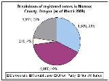
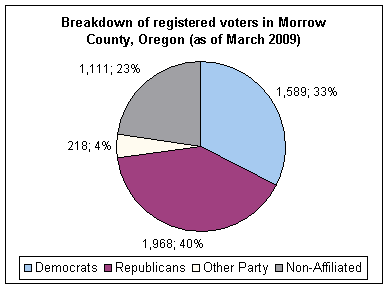
in Morrow County are members of the Republican Party
. In the 2008 presidential election
61.94% of Morrow County voters voted for Republican John McCain
, while 34.62% voted for Democrat
Barack Obama
and 3.44% of voters either voted for a Third Party
candidate or wrote in a candidate
. These numbers show a slight shift towards the Democratic candidate when compared to the 2004 presidential election
, in which 64.8% of Morrow Country voters voted for George W. Bush
, while 33.8% voted for John Kerry
, and 1.4% of voters either voted for a Third Party candidate or wrote in a candidate
.
, the county has a total area of 2047 square miles (5,301.7 km²) of which 2031 square miles (5,260.3 km²) is land and 16 square miles (41.4 km²) or (0.97%) is water.
of 2000, there were 10,995 people, 3,776 households, and 2,718 families residing in the county. The population density
was 5 people per square mile (2/km²). There were 4,296 housing units at an average density of 2 per square mile (1/km²). The racial makeup of the county was 76.27% White
, 0.14% Black
or African American
, 1.42% Native American
, 0.45% Asian
, 0.08% Pacific Islander
, 19.54% from other races
, and 2.14% from two or more races. 24.43% of the population were Hispanic
or Latino
of any race. 13.6% were of German, 12.8% American
, 8.3% Irish
and 8.0% English
ancestry according to Census 2000. 77.3% spoke English
and 22.3% Spanish
as their first language.
There were 3,776 households out of which 38.91% had children under the age of 18 living with them, 62.60% were married couples
living together, 8.87% had a female householder with no husband present, and 22.70% were non-families. 18.13% of all households were made up of individuals and 7.40% had someone living alone who was 65 years of age or older. The average household size was 2.90 and the average family size was 3.28.
In the county, the population was spread out with 30.80% under the age of 18, 8.90% from 18 to 24, 27.30% from 25 to 44, 22.40% from 45 to 64, and 10.60% who were 65 years of age or older. The median age was 33 years. For every 100 females there were 106.50 males. For every 100 females age 18 and over, there were 106.10 males.
The median income for a household in the county was $37,525, and the median income for a family was $40,731. Males had a median income of $32,328 versus $22,887 for females. The per capita income
for the county was $15,843. 14.80% of the population and 11.30% of families are below the poverty line. Out of the total population, 21.60% of those under the age of 18 and 10.1% of those 65 and older were living below the poverty line.
U.S. state
A U.S. state is any one of the 50 federated states of the United States of America that share sovereignty with the federal government. Because of this shared sovereignty, an American is a citizen both of the federal entity and of his or her state of domicile. Four states use the official title of...
of Oregon
Oregon
Oregon is a state in the Pacific Northwest region of the United States. It is located on the Pacific coast, with Washington to the north, California to the south, Nevada on the southeast and Idaho to the east. The Columbia and Snake rivers delineate much of Oregon's northern and eastern...
, on the south side of the Columbia River
Columbia River
The Columbia River is the largest river in the Pacific Northwest region of North America. The river rises in the Rocky Mountains of British Columbia, Canada, flows northwest and then south into the U.S. state of Washington, then turns west to form most of the border between Washington and the state...
. It is included in the 8 county definition of Eastern Oregon
Eastern Oregon
Eastern Oregon is the eastern part of the U.S. state of Oregon. It is not an officially recognized geographic entity, thus the boundaries of the region vary according to context. It is sometimes understood to include only the eight easternmost counties in the state; in other contexts, it includes...
. The county is named for one of its first white settlers, Jackson L. Morrow, who was a member of the state legislature when the county was created. Half of the Umatilla Chemical Depot
Umatilla Chemical Depot
The Umatilla Chemical Depot, based in Umatilla, Oregon, was a U.S. Army installations in the United States that stored chemical weapons. The chemical weapons originally stored at the depot consisted of various munitions and ton containers containing GB and VX nerve agents and HD blister agent...
, which includes the Umatilla Chemical Agent Disposal Facility, is located within the county. In 2010, the county's population was 11,173. The seat
County seat
A county seat is an administrative center, or seat of government, for a county or civil parish. The term is primarily used in the United States....
of the county is Heppner
Heppner, Oregon
The city of Heppner is the county seat of Morrow County, Oregon, United States. It was originally called Standsbury Flat for George W. Standsbury, one of the first white settlers in the area. It was later renamed to honor Henry Heppner, a Jewish pioneer who opened the first general store there in...
.
Morrow County is part of the Pendleton
Pendleton, Oregon
Pendleton is a city in Umatilla County, Oregon, United States. Pendleton was named in 1868 by the county commissioners for George H. Pendleton, Democratic candidate for Vice-President in the 1864 presidential campaign. The population was 16,612 at the 2010 census...
–Hermiston
Hermiston, Oregon
As of the census of 2010, there were 16,745 people, 4,964 households, and 3,360 families residing in the city. The population density was 2,035.4 people per square mile . There were 5,383 housing units at an average density of 832.9 per square mile...
Micropolitan Statistical Area.
History
Morrow County was created on February 15, 1884 from the western portion of Umatilla CountyUmatilla County, Oregon
Umatilla County is a county located in the U.S. state of Oregon. It is included in the 8 county definition of Eastern Oregon. The county is named for the Umatilla River. In 2010, its population was 75,889...
and a small portion of eastern Wasco County
Wasco County, Oregon
Wasco County is a county located in the U.S. state of Oregon. The county is named for a local tribe of Native Americans, the Wasco, a Chinook tribe who lived on the south side of the Columbia River. In 2010, its population was 25,213...
. Heppner
Heppner, Oregon
The city of Heppner is the county seat of Morrow County, Oregon, United States. It was originally called Standsbury Flat for George W. Standsbury, one of the first white settlers in the area. It was later renamed to honor Henry Heppner, a Jewish pioneer who opened the first general store there in...
was designated the temporary county seat at the time the county was created and narrowly defeated Lexington
Lexington, Oregon
Lexington is a city in Morrow County, Oregon, United States. The population was 263 at the 2000 census. It is part of the Pendleton–Hermiston Micropolitan Statistical Area.-History:...
in the election held in 1887 to determine the permanent county seat.
Economy
The principal industries in the county today include agriculture, food processing, lumber, livestock, and recreation. The Columbia River also provides Morrow County with a number of related jobs. A coal-fired generating plant in BoardmanBoardman, Oregon
Boardman is a city in Morrow County, Oregon, United States on the Columbia River and Interstate 84. As of the 2010 census the population was 3,220. It is part of the Pendleton–Hermiston Micropolitan Statistical Area.-History:...
also employs a significant number of people.
Early cattlemen found an abundance of rye
Rye
Rye is a grass grown extensively as a grain and as a forage crop. It is a member of the wheat tribe and is closely related to barley and wheat. Rye grain is used for flour, rye bread, rye beer, some whiskeys, some vodkas, and animal fodder...
along the creek bottoms of the region and drove their herds into the area to forage on these natural pastures. Ranching was the primary economic force in the county for many years. Increased settlement, the enclosure of the free grazing lands and diminished pastures due to overgrazing, resulted in the decline of ranching during the 19th century, and farming became predominant. The completion of rail lines into the county in 1883 increased access to markets and encouraged wheat production in the area. The advent of technology for center pivot irrigation has been a further stimulus to the local economy.
The Morrow Port District, situated on the Columbia River
Columbia River
The Columbia River is the largest river in the Pacific Northwest region of North America. The river rises in the Rocky Mountains of British Columbia, Canada, flows northwest and then south into the U.S. state of Washington, then turns west to form most of the border between Washington and the state...
near the town of Boardman, was established in 1957.
The coal-fired electricity generation plant, the Boardman Turbine Coal Plant (601 megawatts), is located 14 miles (22.5 km) southwest of the town of Boardman, and is owned by Portland General Electric
Portland General Electric
Portland General Electric is an electrical utility based in Portland in the U.S. state of Oregon. It distributes electricity to customers in parts of Multnomah, Clackamas, Marion, Yamhill, Washington, and Polk counties - half of the inhabitants of Oregon...
(PGE; 66%-owned and operated), Idaho Power
Idaho Power Company
Idaho Power Company is a regulated electrical power utility. Its business involves the purchase, sale, generation, transmission and distribution of electricity in eastern Oregon and southern Idaho. It is a subsidiary of IDACORP, Inc...
(10%), Pacific Northwest Generating (10%), and General Electric Credit Corp. (16%). There are also two natural gas
Natural gas
Natural gas is a naturally occurring gas mixture consisting primarily of methane, typically with 0–20% higher hydrocarbons . It is found associated with other hydrocarbon fuel, in coal beds, as methane clathrates, and is an important fuel source and a major feedstock for fertilizers.Most natural...
-fired plants located at the Port of Morrow; Coyote Springs I (255-276 MW), owned and operated by Portland General Electric; and Coyote Springs II (241-280 MW; PGE operator) owned by Avista Corp.
Politics
Like all counties in eastern Oregon, the majority of registered voters who are part of a political partyPolitical party
A political party is a political organization that typically seeks to influence government policy, usually by nominating their own candidates and trying to seat them in political office. Parties participate in electoral campaigns, educational outreach or protest actions...
in Morrow County are members of the Republican Party
Republican Party (United States)
The Republican Party is one of the two major contemporary political parties in the United States, along with the Democratic Party. Founded by anti-slavery expansion activists in 1854, it is often called the GOP . The party's platform generally reflects American conservatism in the U.S...
. In the 2008 presidential election
United States presidential election, 2008
The United States presidential election of 2008 was the 56th quadrennial presidential election. It was held on November 4, 2008. Democrat Barack Obama, then the junior United States Senator from Illinois, defeated Republican John McCain, the senior U.S. Senator from Arizona. Obama received 365...
61.94% of Morrow County voters voted for Republican John McCain
John McCain
John Sidney McCain III is the senior United States Senator from Arizona. He was the Republican nominee for president in the 2008 United States election....
, while 34.62% voted for Democrat
Democratic Party (United States)
The Democratic Party is one of two major contemporary political parties in the United States, along with the Republican Party. The party's socially liberal and progressive platform is largely considered center-left in the U.S. political spectrum. The party has the lengthiest record of continuous...
Barack Obama
Barack Obama
Barack Hussein Obama II is the 44th and current President of the United States. He is the first African American to hold the office. Obama previously served as a United States Senator from Illinois, from January 2005 until he resigned following his victory in the 2008 presidential election.Born in...
and 3.44% of voters either voted for a Third Party
Third party (politics)
In a two-party system of politics, the term third party is sometimes applied to a party other than the two dominant ones. While technically the term is limited to the third largest party or third oldest party, it is common, though innumerate, shorthand for any smaller party.For instance, in the...
candidate or wrote in a candidate
Write-in candidate
A write-in candidate is a candidate in an election whose name does not appear on the ballot, but for whom voters may vote nonetheless by writing in the person's name. Some states and local jurisdictions allow a voter to affix a sticker with a write-in candidate's name on it to the ballot in lieu...
. These numbers show a slight shift towards the Democratic candidate when compared to the 2004 presidential election
United States presidential election, 2004
The United States presidential election of 2004 was the United States' 55th quadrennial presidential election. It was held on Tuesday, November 2, 2004. Republican Party candidate and incumbent President George W. Bush defeated Democratic Party candidate John Kerry, the then-junior U.S. Senator...
, in which 64.8% of Morrow Country voters voted for George W. Bush
George W. Bush
George Walker Bush is an American politician who served as the 43rd President of the United States, from 2001 to 2009. Before that, he was the 46th Governor of Texas, having served from 1995 to 2000....
, while 33.8% voted for John Kerry
John Kerry
John Forbes Kerry is the senior United States Senator from Massachusetts, the 10th most senior U.S. Senator and chairman of the Senate Foreign Relations Committee. He was the presidential nominee of the Democratic Party in the 2004 presidential election, but lost to former President George W...
, and 1.4% of voters either voted for a Third Party candidate or wrote in a candidate
Write-in candidate
A write-in candidate is a candidate in an election whose name does not appear on the ballot, but for whom voters may vote nonetheless by writing in the person's name. Some states and local jurisdictions allow a voter to affix a sticker with a write-in candidate's name on it to the ballot in lieu...
.
Geography
According to the U.S. Census BureauUnited States Census Bureau
The United States Census Bureau is the government agency that is responsible for the United States Census. It also gathers other national demographic and economic data...
, the county has a total area of 2047 square miles (5,301.7 km²) of which 2031 square miles (5,260.3 km²) is land and 16 square miles (41.4 km²) or (0.97%) is water.
Adjacent counties
- Gilliam County, OregonGilliam County, Oregon-Demographics:As of the census of 2000, there were 1,915 people, 819 households, and 543 families residing in the county. The population density was 2 people per square mile . There were 1,043 housing units at an average density of 1 per square mile...
- west - Wheeler County, OregonWheeler County, OregonAs of the census of 2000, there were 1,547 people, 653 households, and 444 families residing in the county. The population density was 1 people per square mile . There were 842 housing units at an average density of 0 per square mile...
- southwest - Grant County, OregonGrant County, OregonGrant County is a county located in the U.S. state of Oregon. It is included in the 8 county definition of Eastern Oregon. In 2010, its population was 7,445. It is named for President Ulysses S. Grant, who served as an army officer in the Oregon Territory, and at the time of the county's creation...
- south - Umatilla County, OregonUmatilla County, OregonUmatilla County is a county located in the U.S. state of Oregon. It is included in the 8 county definition of Eastern Oregon. The county is named for the Umatilla River. In 2010, its population was 75,889...
- east - Benton County, WashingtonBenton County, WashingtonBenton County is a county located in the south-central portion of the U.S. state of Washington. The Columbia River makes up the north, south, and east boundaries of the county. In 2010, its population was 175,177. The county seat is Prosser, and its largest city is Kennewick...
- north - Klickitat County, Washington - northwest
National protected areas
- Umatilla National ForestUmatilla National ForestThe Umatilla National Forest, in the Blue Mountains of northeast Oregon and southeast Washington, covers an area of 1.4 million acres . In descending order of land area the forest is located in parts of Umatilla, Grant, Columbia, Morrow, Wallowa, Union, Garfield, Asotin, Wheeler, and Walla Walla...
(part) - Umatilla National Wildlife RefugeUmatilla National Wildlife RefugeThe Umatilla National Wildlife Refuge is located on and around the Columbia River about northwest of Hermiston, Oregon and includes in Oregon, and in Washington. It was established in 1969 to help mitigate habitat lose due to the flooding that occurred following the construction of the John Day...
(part)
Demographics
As of the censusCensus
A census is the procedure of systematically acquiring and recording information about the members of a given population. It is a regularly occurring and official count of a particular population. The term is used mostly in connection with national population and housing censuses; other common...
of 2000, there were 10,995 people, 3,776 households, and 2,718 families residing in the county. The population density
Population density
Population density is a measurement of population per unit area or unit volume. It is frequently applied to living organisms, and particularly to humans...
was 5 people per square mile (2/km²). There were 4,296 housing units at an average density of 2 per square mile (1/km²). The racial makeup of the county was 76.27% White
Race (United States Census)
Race and ethnicity in the United States Census, as defined by the Federal Office of Management and Budget and the United States Census Bureau, are self-identification data items in which residents choose the race or races with which they most closely identify, and indicate whether or not they are...
, 0.14% Black
Race (United States Census)
Race and ethnicity in the United States Census, as defined by the Federal Office of Management and Budget and the United States Census Bureau, are self-identification data items in which residents choose the race or races with which they most closely identify, and indicate whether or not they are...
or African American
Race (United States Census)
Race and ethnicity in the United States Census, as defined by the Federal Office of Management and Budget and the United States Census Bureau, are self-identification data items in which residents choose the race or races with which they most closely identify, and indicate whether or not they are...
, 1.42% Native American
Race (United States Census)
Race and ethnicity in the United States Census, as defined by the Federal Office of Management and Budget and the United States Census Bureau, are self-identification data items in which residents choose the race or races with which they most closely identify, and indicate whether or not they are...
, 0.45% Asian
Race (United States Census)
Race and ethnicity in the United States Census, as defined by the Federal Office of Management and Budget and the United States Census Bureau, are self-identification data items in which residents choose the race or races with which they most closely identify, and indicate whether or not they are...
, 0.08% Pacific Islander
Race (United States Census)
Race and ethnicity in the United States Census, as defined by the Federal Office of Management and Budget and the United States Census Bureau, are self-identification data items in which residents choose the race or races with which they most closely identify, and indicate whether or not they are...
, 19.54% from other races
Race (United States Census)
Race and ethnicity in the United States Census, as defined by the Federal Office of Management and Budget and the United States Census Bureau, are self-identification data items in which residents choose the race or races with which they most closely identify, and indicate whether or not they are...
, and 2.14% from two or more races. 24.43% of the population were Hispanic
Race (United States Census)
Race and ethnicity in the United States Census, as defined by the Federal Office of Management and Budget and the United States Census Bureau, are self-identification data items in which residents choose the race or races with which they most closely identify, and indicate whether or not they are...
or Latino
Race (United States Census)
Race and ethnicity in the United States Census, as defined by the Federal Office of Management and Budget and the United States Census Bureau, are self-identification data items in which residents choose the race or races with which they most closely identify, and indicate whether or not they are...
of any race. 13.6% were of German, 12.8% American
United States
The United States of America is a federal constitutional republic comprising fifty states and a federal district...
, 8.3% Irish
Irish people
The Irish people are an ethnic group who originate in Ireland, an island in northwestern Europe. Ireland has been populated for around 9,000 years , with the Irish people's earliest ancestors recorded having legends of being descended from groups such as the Nemedians, Fomorians, Fir Bolg, Tuatha...
and 8.0% English
English people
The English are a nation and ethnic group native to England, who speak English. The English identity is of early mediaeval origin, when they were known in Old English as the Anglecynn. England is now a country of the United Kingdom, and the majority of English people in England are British Citizens...
ancestry according to Census 2000. 77.3% spoke English
English language
English is a West Germanic language that arose in the Anglo-Saxon kingdoms of England and spread into what was to become south-east Scotland under the influence of the Anglian medieval kingdom of Northumbria...
and 22.3% Spanish
Spanish language
Spanish , also known as Castilian , is a Romance language in the Ibero-Romance group that evolved from several languages and dialects in central-northern Iberia around the 9th century and gradually spread with the expansion of the Kingdom of Castile into central and southern Iberia during the...
as their first language.
There were 3,776 households out of which 38.91% had children under the age of 18 living with them, 62.60% were married couples
Marriage
Marriage is a social union or legal contract between people that creates kinship. It is an institution in which interpersonal relationships, usually intimate and sexual, are acknowledged in a variety of ways, depending on the culture or subculture in which it is found...
living together, 8.87% had a female householder with no husband present, and 22.70% were non-families. 18.13% of all households were made up of individuals and 7.40% had someone living alone who was 65 years of age or older. The average household size was 2.90 and the average family size was 3.28.
In the county, the population was spread out with 30.80% under the age of 18, 8.90% from 18 to 24, 27.30% from 25 to 44, 22.40% from 45 to 64, and 10.60% who were 65 years of age or older. The median age was 33 years. For every 100 females there were 106.50 males. For every 100 females age 18 and over, there were 106.10 males.
The median income for a household in the county was $37,525, and the median income for a family was $40,731. Males had a median income of $32,328 versus $22,887 for females. The per capita income
Per capita income
Per capita income or income per person is a measure of mean income within an economic aggregate, such as a country or city. It is calculated by taking a measure of all sources of income in the aggregate and dividing it by the total population...
for the county was $15,843. 14.80% of the population and 11.30% of families are below the poverty line. Out of the total population, 21.60% of those under the age of 18 and 10.1% of those 65 and older were living below the poverty line.
Incorporated cities
- BoardmanBoardman, OregonBoardman is a city in Morrow County, Oregon, United States on the Columbia River and Interstate 84. As of the 2010 census the population was 3,220. It is part of the Pendleton–Hermiston Micropolitan Statistical Area.-History:...
- HeppnerHeppner, OregonThe city of Heppner is the county seat of Morrow County, Oregon, United States. It was originally called Standsbury Flat for George W. Standsbury, one of the first white settlers in the area. It was later renamed to honor Henry Heppner, a Jewish pioneer who opened the first general store there in...
- IoneIone, OregonIone is a city in Morrow County, Oregon, United States. The population was 321 at the 2000 census. It is part of the Pendleton–Hermiston Micropolitan Statistical Area.-Geography:Ione lies along Oregon Route 74, northwest of Heppner...
- IrrigonIrrigon, OregonIrrigon is a city in Morrow County, Oregon, United States, on the Columbia River and U.S. Route 730. Irrigon was incorporated on February 28, 1957. The Umatilla Chemical Depot, and the Umatilla Chemical Agent Disposal Facility, is located four-miles south of the city, northeast of the intersection...
- LexingtonLexington, OregonLexington is a city in Morrow County, Oregon, United States. The population was 263 at the 2000 census. It is part of the Pendleton–Hermiston Micropolitan Statistical Area.-History:...
Unincorporated communities
|
Lena, Oregon Lena is an unincorporated community in Morrow County, Oregon, United States. It is located on Oregon Route 74. The community was named by C. E. Hinton, who was Lena's first postmaster, and J. S. Vinson. The post office operated from June 11, 1873 to August 31, 1942. Lena is now served by the... Morgan, Oregon Morgan is an unincorporated community in Morrow County, Oregon, United States on Heppner Highway 74.... Ruggs, Oregon Ruggs is an unincorporated community in Morrow County, Oregon, United States. Ruggs lies at the intersection of Oregon Route 206 and Oregon Route 207. Ruggs is east of Eightmile and southwest of Heppner. The community is part of the Pendleton–Hermiston Micropolitan Statistical Area.... |
Ghost Towns
- Castle Rock (former post office)
- HardmanHardman, OregonHardman is an incorporated March 2, 1904 historic community in Morrow County, Oregon, United States on Oregon Route 207 north of Rock Creek. It is considered a ghost town.The first settlers in the area were John F. Royse and his brother...
Major Roads
-
 Interstate 84Interstate 84 (west)Interstate 84 is an Interstate Highway in the Western United States that runs from Portland, Oregon, to a junction with Interstate 80 near Echo, Utah. The highway originally served as a fork of I-80 to serve the Pacific Northwest, and was originally numbered Interstate 80N.The highway serves and...
 - Oregon State Route 74
- Oregon State Route 206Oregon State Route 206Oregon Route 206 is an Oregon state highway located in the north-central part of the state. It runs from Interstate 84 at Celilo Village to a junction with Oregon Route 74 and Oregon Route 207 in Heppner. Aside from Interstate 84, Oregon Route 206 is the main east–west highway in Gilliam...
- Oregon State Route 207
See also
- National Register of Historic Places listings in Morrow County, Oregon