
Umatilla, Oregon
Encyclopedia
Umatilla is a city in Umatilla County
, Oregon
, United States
. It is named for the Umatilla River
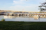
, which enters the Columbia River
on the side of the city. The river is named after the Umatilla
Tribe. The city is located on the south side of the Columbia River, and is located on U.S. Route 730 and I-82
.
The Umatilla Chemical Depot
, and the Umatilla Chemical Agent Disposal Facility, is located four miles (6 km) southwest of the city, northwest of the intersection of I-84 and I-82. The population was 6,980 in 2011 http://pdx.edu/prc/population-estimates-0.
Umatilla is part of the Pendleton
–Hermiston
Micropolitan Statistical Area.
Umatilla's earliest importance was as a trade and distribution center on the Columbia River
, during the gold rush
of the 1860s and 1870s in eastern Oregon
. It remained a major commercial center until the 1880s when it withered before the Oregon Railway and Navigation Company.
The Umatilla Chemical Depot opened in 1941, to gear up for World War II
. The depot's mission was to store and maintain a variety of military
items, from blanket
s to ammunition
. The depot took on its chemical weapons storage mission in 1962. From 1990 to 1994 the facility reorganized in preparation for eventual closure, shipping all conventional ammunition and supplies to other installations. On October 25, 2011 the last barrel of HD mustard agent was destroyed and there is no longer a risk of chemical accident in Oregon and Washington.
.
According to the United States Census Bureau
, the city has a total area of 3.7 square miles (9.6 km²), of which 3.5 square miles (9.1 km²) is land and 0.2 square mile (0.517997622 km²) (5.63%) is water.
of 2000, there were 4,978 people, 1,364 households, and 1,062 families residing in the city. The population density
was 1,415.3 people per square mile (546.0/km²). There were 1,511 housing units at an average density of 429.6 per square mile (165.7/km²). The racial makeup of the city was 72.10% White, 2.69% African American, 1.35% Native American, 0.38% Asian, 0.06% Pacific Islander, 21.49% from other races
, and 1.93% from two or more races. Hispanic or Latino of any race were 32.58% of the population.
There were 1,364 households out of which 45.7% had children under the age of 18 living with them, 58.2% were married couples
living together, 13.0% had a female householder with no husband present, and 22.1% were non-families. 16.9% of all households were made up of individuals and 5.1% had someone living alone who was 65 years of age or older. The average household size was 3.14 and the average family size was 3.51.
In the city the population was spread out with 31.0% under the age of 18, 12.1% from 18 to 24, 34.7% from 25 to 44, 16.5% from 45 to 64, and 5.7% who were 65 years of age or older. The median age was 29 years. For every 100 females there were 137.8 males. For every 100 females age 18 and over, there were 157.3 males.
The median income for a household in the city was $33,844, and the median income for a family was $32,969. Males had a median income of $28,500 versus $20,337 for females. The per capita income
for the city was $11,469. About 15.6% of families and 19.4% of the population were below
the poverty line, including 24.2% of those under age 18 and 21.1% of those age 65 or over.
Umatilla County, Oregon
Umatilla County is a county located in the U.S. state of Oregon. It is included in the 8 county definition of Eastern Oregon. The county is named for the Umatilla River. In 2010, its population was 75,889...
, Oregon
Oregon
Oregon is a state in the Pacific Northwest region of the United States. It is located on the Pacific coast, with Washington to the north, California to the south, Nevada on the southeast and Idaho to the east. The Columbia and Snake rivers delineate much of Oregon's northern and eastern...
, United States
United States
The United States of America is a federal constitutional republic comprising fifty states and a federal district...
. It is named for the Umatilla River
Umatilla River
The Umatilla River is an tributary of the Columbia River in the U.S. state of Oregon. Draining a basin of , it enters the Columbia near the city of Umatilla in the northeastern part of the state...
, which enters the Columbia River
Columbia River
The Columbia River is the largest river in the Pacific Northwest region of North America. The river rises in the Rocky Mountains of British Columbia, Canada, flows northwest and then south into the U.S. state of Washington, then turns west to form most of the border between Washington and the state...
on the side of the city. The river is named after the Umatilla
Umatilla (tribe)
The Umatilla are a Sahaptin-speaking Native American group living on the Umatilla Indian Reservation, who traditionally inhabited the Columbia Plateau region of the northwestern United States....
Tribe. The city is located on the south side of the Columbia River, and is located on U.S. Route 730 and I-82
Interstate 82
Interstate 82 is a Interstate Highway that extends from I-90 in Ellensburg, Washington to I-84 near Umatilla, Oregon in the United States. In the state of Washington, it serves the cities of Ellensburg, Yakima, and the Tri Cities , and in Oregon, it serves Umatilla and Hermiston...
.
The Umatilla Chemical Depot
Umatilla Chemical Depot
The Umatilla Chemical Depot, based in Umatilla, Oregon, was a U.S. Army installations in the United States that stored chemical weapons. The chemical weapons originally stored at the depot consisted of various munitions and ton containers containing GB and VX nerve agents and HD blister agent...
, and the Umatilla Chemical Agent Disposal Facility, is located four miles (6 km) southwest of the city, northwest of the intersection of I-84 and I-82. The population was 6,980 in 2011 http://pdx.edu/prc/population-estimates-0.
Umatilla is part of the Pendleton
Pendleton, Oregon
Pendleton is a city in Umatilla County, Oregon, United States. Pendleton was named in 1868 by the county commissioners for George H. Pendleton, Democratic candidate for Vice-President in the 1864 presidential campaign. The population was 16,612 at the 2010 census...
–Hermiston
Hermiston, Oregon
As of the census of 2010, there were 16,745 people, 4,964 households, and 3,360 families residing in the city. The population density was 2,035.4 people per square mile . There were 5,383 housing units at an average density of 832.9 per square mile...
Micropolitan Statistical Area.
History
The first post office for Umatilla was established September 26, 1851. The present town was surveyed by Timothy K. Davenport in 1863, and the town incorporated as Umatilla Landing in 1864.Umatilla's earliest importance was as a trade and distribution center on the Columbia River
Columbia River
The Columbia River is the largest river in the Pacific Northwest region of North America. The river rises in the Rocky Mountains of British Columbia, Canada, flows northwest and then south into the U.S. state of Washington, then turns west to form most of the border between Washington and the state...
, during the gold rush
Gold rush
A gold rush is a period of feverish migration of workers to an area that has had a dramatic discovery of gold. Major gold rushes took place in the 19th century in Australia, Brazil, Canada, South Africa, and the United States, while smaller gold rushes took place elsewhere.In the 19th and early...
of the 1860s and 1870s in eastern Oregon
Oregon
Oregon is a state in the Pacific Northwest region of the United States. It is located on the Pacific coast, with Washington to the north, California to the south, Nevada on the southeast and Idaho to the east. The Columbia and Snake rivers delineate much of Oregon's northern and eastern...
. It remained a major commercial center until the 1880s when it withered before the Oregon Railway and Navigation Company.
The Umatilla Chemical Depot opened in 1941, to gear up for World War II
World War II
World War II, or the Second World War , was a global conflict lasting from 1939 to 1945, involving most of the world's nations—including all of the great powers—eventually forming two opposing military alliances: the Allies and the Axis...
. The depot's mission was to store and maintain a variety of military
Military
A military is an organization authorized by its greater society to use lethal force, usually including use of weapons, in defending its country by combating actual or perceived threats. The military may have additional functions of use to its greater society, such as advancing a political agenda e.g...
items, from blanket
Blanket
A blanket is a type of bedding, generally speaking, a large piece of cloth, intended to keep the user warm, especially while sleeping. Blankets are distinguished from sheets by their thickness and purpose; the thickest sheet is still thinner than the lightest blanket. Blankets are generally used...
s to ammunition
Ammunition
Ammunition is a generic term derived from the French language la munition which embraced all material used for war , but which in time came to refer specifically to gunpowder and artillery. The collective term for all types of ammunition is munitions...
. The depot took on its chemical weapons storage mission in 1962. From 1990 to 1994 the facility reorganized in preparation for eventual closure, shipping all conventional ammunition and supplies to other installations. On October 25, 2011 the last barrel of HD mustard agent was destroyed and there is no longer a risk of chemical accident in Oregon and Washington.
Geography
Umatilla is located at 45°55′4"N 119°19′35"W (45.917668, -119.326400). It lies 30 miles (48.3 km) northwest of PendletonPendleton, Oregon
Pendleton is a city in Umatilla County, Oregon, United States. Pendleton was named in 1868 by the county commissioners for George H. Pendleton, Democratic candidate for Vice-President in the 1864 presidential campaign. The population was 16,612 at the 2010 census...
.
According to the United States Census Bureau
United States Census Bureau
The United States Census Bureau is the government agency that is responsible for the United States Census. It also gathers other national demographic and economic data...
, the city has a total area of 3.7 square miles (9.6 km²), of which 3.5 square miles (9.1 km²) is land and 0.2 square mile (0.517997622 km²) (5.63%) is water.
Demographics
As of the censusCensus
A census is the procedure of systematically acquiring and recording information about the members of a given population. It is a regularly occurring and official count of a particular population. The term is used mostly in connection with national population and housing censuses; other common...
of 2000, there were 4,978 people, 1,364 households, and 1,062 families residing in the city. The population density
Population density
Population density is a measurement of population per unit area or unit volume. It is frequently applied to living organisms, and particularly to humans...
was 1,415.3 people per square mile (546.0/km²). There were 1,511 housing units at an average density of 429.6 per square mile (165.7/km²). The racial makeup of the city was 72.10% White, 2.69% African American, 1.35% Native American, 0.38% Asian, 0.06% Pacific Islander, 21.49% from other races
Race (United States Census)
Race and ethnicity in the United States Census, as defined by the Federal Office of Management and Budget and the United States Census Bureau, are self-identification data items in which residents choose the race or races with which they most closely identify, and indicate whether or not they are...
, and 1.93% from two or more races. Hispanic or Latino of any race were 32.58% of the population.
There were 1,364 households out of which 45.7% had children under the age of 18 living with them, 58.2% were married couples
Marriage
Marriage is a social union or legal contract between people that creates kinship. It is an institution in which interpersonal relationships, usually intimate and sexual, are acknowledged in a variety of ways, depending on the culture or subculture in which it is found...
living together, 13.0% had a female householder with no husband present, and 22.1% were non-families. 16.9% of all households were made up of individuals and 5.1% had someone living alone who was 65 years of age or older. The average household size was 3.14 and the average family size was 3.51.
In the city the population was spread out with 31.0% under the age of 18, 12.1% from 18 to 24, 34.7% from 25 to 44, 16.5% from 45 to 64, and 5.7% who were 65 years of age or older. The median age was 29 years. For every 100 females there were 137.8 males. For every 100 females age 18 and over, there were 157.3 males.
The median income for a household in the city was $33,844, and the median income for a family was $32,969. Males had a median income of $28,500 versus $20,337 for females. The per capita income
Per capita income
Per capita income or income per person is a measure of mean income within an economic aggregate, such as a country or city. It is calculated by taking a measure of all sources of income in the aggregate and dividing it by the total population...
for the city was $11,469. About 15.6% of families and 19.4% of the population were below
the poverty line, including 24.2% of those under age 18 and 21.1% of those age 65 or over.
Economy
The local economy is heavily reliant on agriculture and supporting services. Umatilla is home to the Two Rivers Correctional Institution which employs 440 people in the Port of Umatilla's McNary Industrial Park. The Port of Umatilla is also home to JM Eagle Manufacturing, Aramark, Hagerman Trucking, Boise Cascade, Pendleton Grain Growers, Tidewater, WM Moss Jr. Corp., Diamond Line Delivery and Amazon.com. Amazon.com recently started developing a data center campus in Umatilla in support of Amazon Web Services.External links
- Entry for Umatilla in the Oregon Blue BookOregon Blue BookThe Oregon Blue Book is the official directory and fact book for the U.S. state of Oregon copyrighted by the Oregon Secretary of State and published by the Office of the Secretary's Archives Division. As Governor Ted Kulongoski notes in his introduction for the 2005–2006 edition, it "provides...