

U.S. Route 44 in New York
Encyclopedia
U.S. Route 44 in the state of New York
is a major east–west thoroughfare in the Hudson Valley
region of the state. Its entire 65.98 miles (106.18 km) length is maintained by the New York State Department of Transportation
, with the exception of the Mid-Hudson Bridge
, which is maintained by the New York State Bridge Authority
. The portion of the route in New York begins at an intersection with US 209 and New York State Route 55 (NY 55) near the hamlet of Kerhonkson
and ends at the Connecticut
state line near the village of Millerton
. The road passes through rural parts of Ulster
and Dutchess
Counties before crossing into Litchfield County, Connecticut
.
Most of the route in Dutchess County was once part of the Dutchess Turnpike, an early road interconnecting Poughkeepsie
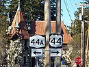
to various settlements in Dutchess County. US 44 was designated ca. 1935 and had no major changes in alignment until 2007, when it was relocated onto New York State Route 44A, a highway that bypassed the village of Millbrook
to the northwest. The NY 44A designation was deleted as a result of the relocation, and signage for NY 44A was taken down in April 2008. US 44's original alignment through Millbrook became NY 984P, an unsigned reference route.
 US 44 begins at an intersection with US 209 and NY 55
west of the hamlet of Kerhonkson
in the town of Wawarsing
in Ulster County
. NY 55, concurrent
with US 209 southwest of this point, turns east onto US 44, forming an overlap as the two routes proceed eastward across Ulster County. Midway between Kerhonkson and Gardiner
and just north of NY 299
, US 44 and NY 55 traverse a hairpin turn
made necessary by the surrounding Shawangunk Ridge
.
Farther east, the road passes through the hamlets of Gardiner and Clintondale
, and meets US 9W
in the hamlet of Highland
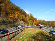
. Just inside of Gardiner, the highway passes through Minnewaska State Park, a large state park in the Hudson Valley
. US 44 and NY 55 join US 9W for roughly a half-mile southward along the western bank of the Hudson River
before separating at a trumpet interchange south of Highland. One mile east of US 9W, US 44 and NY 55 cross the Hudson on the Mid-Hudson Bridge
.
 On the opposite bank in Dutchess County
, US 44 and NY 55 enter the city of Poughkeepsie
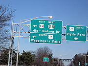
. In the downtown area, US 44 and NY 55 connect with US 9 by way of an interchange before splitting into a pair of parallel one-way streets. At the eastern end of the parallel roadways in Arlington
, just outside of Poughkeepsie, US 44 and NY 55 split upon meeting Main Street at an interchange. NY 55 continues southeast through the junction as Manchester Road; US 44, however, joins Main Street to the northeast along what becomes the Dutchess Turnpike. West of the interchange, state maintenance continues along Main Street for an additional 0.19 mile (0.3057746 km) to County Route 38 (CR 38, named Fairmont Avenue). This segment of Main Street is designated as NY 983W, an unsigned reference route. Past CR 38, Main Street becomes CR 114.
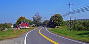
From Arlington, Route 44 bends first to the north, then after 1.5 miles northeast, through intermittently developed areas, woodlot
s, and farms to the next settlement along its route, Pleasant Valley. In its commercial center the road widens to include a center turn lane. After crossing Wappinger Creek
, it returns to two lanes.
The road returns to a more easterly course for two miles, then straightens out as it climbs steadily past the Newcomb-Brown Estate
. It crests just before the interchange with the Taconic State Parkway
. A mile past it, at the state police
Troop A barracks, NY 82
joins from the north and the two roads overlap.
This concurrency ends after another mile, when US 44 diverges along the route of the former NY 44A, going around the village of Millbrook
past the Mary Flagler Cary Arboretum
, home to the Institute of Ecosystem Studies
. The highway returns to a more due-east orientation as it passes north of the village, then gradually curves to the northeast again as it passes through a heavily farmed area.
Route 44 gradually descends into the upper Harlem Valley, with a sharp hairpin turn
providing a panoramic view to the south. A gradual descent takes it into downtown Amenia
. At the center of town, the highway turns north and replaces NY 343
as NY 22
's overlap.
A seven-mile (11 km) journey over increasingly rolling and open terrain takes the two highways into the town of North East
and towards Millerton
. Just south of the village, NY 199
reaches its eastern terminus. The road enters Millerton on South Elm Street, making a sharp turn north that necessitates a concrete barrier and lower speed limit just south of downtown.
At the traffic light just north of that bend, US 44 leaves NY 22 and turns right through Millerton's historic downtown. Maple Avenue on the south marks the former northern terminus of NY 361. After that junction, Route 44 leaves the village. It passes some strip development on the south, bends slightly to the north and crosses the Connecticut
state line just past a car dealership on the south.
 The portion of US 44 between Poughkeepsie
and Amenia
was the main line of an early toll road known as the Dutchess Turnpike. The turnpike continued past Amenia into the Connecticut
town of Sharon
along modern NY 343
. Between the Wallkill River
near the hamlet of Gardiner
and the hamlet of Ardonia, modern US 44 was also roughly located along another early toll road known as the Farmer's Turnpike. The Farmer's Turnpike continued east past Ardonia to the village of Milton
where a ferry across the Hudson River
once existed.
In 1924, when state highways were first marked by route numbers in New York, the main line of the Dutchess Turnpike was designated as NY 21. Other portions of modern US 44, aside from the overlap with NY 22
, were unnumbered in the 1920s. In the 1930 renumbering of state highways in New York, the old NY 21 was partitioned into three numbered routes. Between Poughkeepsie and South Millbrook, old NY 21 became the western half of NY 200, which continued east to Dover Plains
using the Dover branch route of the Dutchess Turnpike (modern NY 343). The section from South Millbrook to Amenia became part of NY 82A, which continued past Amenia to Pine Plains
. The easternmost section from Amenia to the Connecticut line was designated as NY 343. West of the Hudson River, NY 55
was also designated in 1930 between Barryville
and Pawling
, running along the portion of modern US 44 between Kerhonkson
and Poughkeepsie.
 US 44 was assigned ca. 1935. West of the Hudson River, it was overlaid on the pre-existing NY 55, with US 44 officially beginning at US 209, which was extended into New York ca. 1935. East of the river, US 44 was routed on the original Dutchess Turnpike main line from Poughkeepsie to Amenia, supplanting NY 200 west of South Millbrook, NY 82A west of Amenia, and a short portion of NY 343 between NY 82A and the hamlet of Amenia. US 44 left the turnpike at Amenia and followed NY 22 north to Millerton
, where it continued east on a short piece of former NY 199
into Connecticut
. The alignments of NY 200 and NY 343 were flipped as part of US 44's assignment.
US 44 originally entered the village of Millbrook via NY 82
, North Avenue, and Franklin Avenue. On April 1, 1980, the state of New York assumed ownership of a highway bypassing Millbrook to the west and north as part of a highway maintenance swap between the state and Dutchess County. The newly-acquired roadway was designated as NY 44A. On June 5, 2007, the New York State Department of Transportation
(NYSDOT) announced that US 44 would be permanently realigned onto NY 44A. All shields along NY 44A were replaced with US 44 signage, and the NY 44A designation ceased to exist. NYSDOT will continue to perform maintenance on US 44's former routing through Millbrook. The portion of the routing that did not overlap NY 82 is now NY 984P, an unsigned reference route.
New York
New York is a state in the Northeastern region of the United States. It is the nation's third most populous state. New York is bordered by New Jersey and Pennsylvania to the south, and by Connecticut, Massachusetts and Vermont to the east...
is a major east–west thoroughfare in the Hudson Valley
Hudson Valley
The Hudson Valley comprises the valley of the Hudson River and its adjacent communities in New York State, United States, from northern Westchester County northward to the cities of Albany and Troy.-History:...
region of the state. Its entire 65.98 miles (106.18 km) length is maintained by the New York State Department of Transportation
New York State Department of Transportation
The New York State Department of Transportation is responsible for the development and operation of highways, railroads, mass transit systems, ports, waterways and aviation facilities in the U.S...
, with the exception of the Mid-Hudson Bridge
Mid-Hudson Bridge
The Mid-Hudson Bridge is a toll suspension bridge which carries US 44 and NY 55 across the Hudson River between Poughkeepsie and Highland in the state of New York. Governor and local resident Franklin D. Roosevelt and his wife Eleanor attended the opening ceremony on August 25, 1930. The bridge...
, which is maintained by the New York State Bridge Authority
New York State Bridge Authority
The New York State Bridge Authority is a public benefit corporation in New York State, United States. The NYSBA was born out of the necessity for a bridge over the Hudson River to link the city of Hudson and the village of Catskill.-History:...
. The portion of the route in New York begins at an intersection with US 209 and New York State Route 55 (NY 55) near the hamlet of Kerhonkson
Kerhonkson, New York
Kerhonkson is a hamlet in Ulster County, New York, United States. The population was 1,684 at the 2010 census.Kerhonkson is a small hamlet which, along with Accord, makes up the Town of Rochester on US 209, just south of the town's boundary with the Town of Wawarsing and just north of where US 44...
and ends at the Connecticut
Connecticut
Connecticut is a state in the New England region of the northeastern United States. It is bordered by Rhode Island to the east, Massachusetts to the north, and the state of New York to the west and the south .Connecticut is named for the Connecticut River, the major U.S. river that approximately...
state line near the village of Millerton
Millerton, New York
Millerton is a village in Dutchess County, New York, United States. The population was 925 at the 2000 census. It is part of the Poughkeepsie–Newburgh–Middletown, NY Metropolitan Statistical Area as well as the larger New York–Newark–Bridgeport, NY-NJ-CT-PA Combined...
. The road passes through rural parts of Ulster
Ulster County, New York
Ulster County is a county located in the state of New York, USA. It sits in the state's Mid-Hudson Region of the Hudson Valley. As of the 2010 census, the population was 182,493. Recent population estimates completed by the United States Census Bureau for the 12-month period ending July 1 are at...
and Dutchess
Dutchess County, New York
Dutchess County is a county located in the U.S. state of New York, in the state's Mid-Hudson Region of the Hudson Valley. The 2010 census lists the population as 297,488...
Counties before crossing into Litchfield County, Connecticut
Litchfield County, Connecticut
Litchfield County is a county located in the northwestern corner of the U.S. state of Connecticut. Litchfield County has the lowest population density of any county in Connecticut but is geographically the state's largest county. As of 2010 the population was 189,927...
.
Most of the route in Dutchess County was once part of the Dutchess Turnpike, an early road interconnecting Poughkeepsie
Poughkeepsie (city), New York
Poughkeepsie is a city in the state of New York, United States, which serves as the county seat of Dutchess County. Poughkeepsie is located in the Hudson River Valley midway between New York City and Albany...
to various settlements in Dutchess County. US 44 was designated ca. 1935 and had no major changes in alignment until 2007, when it was relocated onto New York State Route 44A, a highway that bypassed the village of Millbrook
Millbrook, New York
Millbrook is a village in Dutchess County, New York, United States. It is often said to be a "low-key version of the Hamptons" and one of the wealthiest towns in New York State. Millbrook's estimated town population was 1,551 in 2008. Millbrook is located in the Hudson Valley, an hour and thirty...
to the northwest. The NY 44A designation was deleted as a result of the relocation, and signage for NY 44A was taken down in April 2008. US 44's original alignment through Millbrook became NY 984P, an unsigned reference route.
Route description
New York State Route 55
New York State Route 55 is a state highway in southern New York, running from the Pennsylvania state line at the Delaware River in Barryville to the Connecticut state line at Wingdale...
west of the hamlet of Kerhonkson
Kerhonkson, New York
Kerhonkson is a hamlet in Ulster County, New York, United States. The population was 1,684 at the 2010 census.Kerhonkson is a small hamlet which, along with Accord, makes up the Town of Rochester on US 209, just south of the town's boundary with the Town of Wawarsing and just north of where US 44...
in the town of Wawarsing
Wawarsing, New York
Wawarsing is a town in Ulster County, New York, United States. The population was 13,157 at the 2010 census. The name means "a place where the stream bends" in the Warwarsink language and refers to the geography of the land; particularly the joining of the Ver Nooy Kill and the Rondout Creek. The...
in Ulster County
Ulster County, New York
Ulster County is a county located in the state of New York, USA. It sits in the state's Mid-Hudson Region of the Hudson Valley. As of the 2010 census, the population was 182,493. Recent population estimates completed by the United States Census Bureau for the 12-month period ending July 1 are at...
. NY 55, concurrent
Concurrency (road)
A concurrency, overlap, or coincidence in a road network is an instance of one physical road bearing two or more different highway, motorway, or other route numbers...
with US 209 southwest of this point, turns east onto US 44, forming an overlap as the two routes proceed eastward across Ulster County. Midway between Kerhonkson and Gardiner
Gardiner, New York
Gardiner is a town in Ulster County, New York, USA. The population was 5,238 at the 2000 census.The Town of Gardiner is in the south-central part of the county.- History :...
and just north of NY 299
New York State Route 299
New York State Route 299 is a short but important state route entirely within Ulster County, New York, United States. Centered around its interchange with the New York State Thruway outside New Paltz, it provides access from that road to the popular recreational attractions of the Shawangunk...
, US 44 and NY 55 traverse a hairpin turn
Hairpin turn
A hairpin turn , named for its resemblance to a hairpin/bobby pin, is a bend in a road with a very acute inner angle, making it necessary for an oncoming vehicle to turn almost 180° to continue on the road. Such turns in ramps and trails may be called switchbacks in American English, by analogy...
made necessary by the surrounding Shawangunk Ridge
Shawangunk Ridge
The Shawangunk Ridge , also known as the Shawangunk Mountains or The Gunks, is a ridge of bedrock in Ulster County, Sullivan County and Orange County in the state of New York, extending from the northernmost point of New Jersey to the Catskill Mountains.The ridgetop, which widens considerably at...
.
Farther east, the road passes through the hamlets of Gardiner and Clintondale
Clintondale, New York
Clintondale is a hamlet in Ulster County, New York, United States. The population was 1,424 at the 2000 census.Clintondale is located at the north town line of the Town of Plattekill...
, and meets US 9W
U.S. Route 9W
U.S. Route 9W is a north–south U.S. Highway in the states of New Jersey and New York. It begins on Fletcher Avenue in Fort Lee, New Jersey as it crosses the US 1 & 9, US 46, and the Interstate 95 approaches to the George Washington Bridge, where it heads north up the west...
in the hamlet of Highland
Highland, Ulster County, New York
Highland is a hamlet in Ulster County, New York, United States. The population was 5,060 at the 2000 census.Highland is a community in the Town of Lloyd, on U.S. Route 9W. Routes 44 and 55 run through it as well...
. Just inside of Gardiner, the highway passes through Minnewaska State Park, a large state park in the Hudson Valley
Hudson Valley
The Hudson Valley comprises the valley of the Hudson River and its adjacent communities in New York State, United States, from northern Westchester County northward to the cities of Albany and Troy.-History:...
. US 44 and NY 55 join US 9W for roughly a half-mile southward along the western bank of the Hudson River
Hudson River
The Hudson is a river that flows from north to south through eastern New York. The highest official source is at Lake Tear of the Clouds, on the slopes of Mount Marcy in the Adirondack Mountains. The river itself officially begins in Henderson Lake in Newcomb, New York...
before separating at a trumpet interchange south of Highland. One mile east of US 9W, US 44 and NY 55 cross the Hudson on the Mid-Hudson Bridge
Mid-Hudson Bridge
The Mid-Hudson Bridge is a toll suspension bridge which carries US 44 and NY 55 across the Hudson River between Poughkeepsie and Highland in the state of New York. Governor and local resident Franklin D. Roosevelt and his wife Eleanor attended the opening ceremony on August 25, 1930. The bridge...
.
Dutchess County, New York
Dutchess County is a county located in the U.S. state of New York, in the state's Mid-Hudson Region of the Hudson Valley. The 2010 census lists the population as 297,488...
, US 44 and NY 55 enter the city of Poughkeepsie
Poughkeepsie (city), New York
Poughkeepsie is a city in the state of New York, United States, which serves as the county seat of Dutchess County. Poughkeepsie is located in the Hudson River Valley midway between New York City and Albany...
. In the downtown area, US 44 and NY 55 connect with US 9 by way of an interchange before splitting into a pair of parallel one-way streets. At the eastern end of the parallel roadways in Arlington
Arlington, New York
Arlington is a community in Dutchess County, New York, United States. As of the 2000 census, the CDP population was 12,481.Arlington is a suburb of the City of Poughkeepsie and is in the Town of Poughkeepsie...
, just outside of Poughkeepsie, US 44 and NY 55 split upon meeting Main Street at an interchange. NY 55 continues southeast through the junction as Manchester Road; US 44, however, joins Main Street to the northeast along what becomes the Dutchess Turnpike. West of the interchange, state maintenance continues along Main Street for an additional 0.19 mile (0.3057746 km) to County Route 38 (CR 38, named Fairmont Avenue). This segment of Main Street is designated as NY 983W, an unsigned reference route. Past CR 38, Main Street becomes CR 114.
From Arlington, Route 44 bends first to the north, then after 1.5 miles northeast, through intermittently developed areas, woodlot
Woodlot
A woodlot is a term used in North America to refer to a segment of a woodland or forest capable of small-scale production of forest products such as wood fuel, sap for maple syrup, sawlogs, as well as recreational uses like bird watching, bushwalking, and wildflower appreciation...
s, and farms to the next settlement along its route, Pleasant Valley. In its commercial center the road widens to include a center turn lane. After crossing Wappinger Creek
Wappinger Creek
Wappinger Creek is a creek which runs from Thompson Pond to the Hudson River at New Hamburg in Dutchess County, New York, United States. It is the longest creek in Dutchess County, with the largest watershed in the county.- Overview :...
, it returns to two lanes.
The road returns to a more easterly course for two miles, then straightens out as it climbs steadily past the Newcomb-Brown Estate
Newcomb-Brown Estate
The Newcomb-Brown Estate is located at the junction of the US 44 highway and Brown Road in Pleasant Valley, New York, United States. It is a brick structure built in the 18th century just before the Revolution and modified slightly by later owners but generally intact...
. It crests just before the interchange with the Taconic State Parkway
Taconic State Parkway
The Taconic State Parkway , is a divided highway between Kensico Dam and Chatham, the longest parkway in the U.S. state of New York. It follows a generally northward route midway between the Hudson River and the Connecticut and Massachusetts state lines...
. A mile past it, at the state police
New York State Police
The New York State Police is the state police force of over 4,600 sworn Troopers for the state of New York. It was established on April 11, 1917 by the New York Legislature, in response to the 1913 murder of a construction foreman named Sam Howell in Westchester County, which at that time did not...
Troop A barracks, NY 82
New York State Route 82
New York State Route 82 is a state highway in the eastern Hudson Valley of New York, United States. It begins at an intersection with NY 52 northeast of the village of Fishkill, bends eastward towards Millbrook, and then returns westward to end at a junction with U.S. Route 9,...
joins from the north and the two roads overlap.
This concurrency ends after another mile, when US 44 diverges along the route of the former NY 44A, going around the village of Millbrook
Millbrook, New York
Millbrook is a village in Dutchess County, New York, United States. It is often said to be a "low-key version of the Hamptons" and one of the wealthiest towns in New York State. Millbrook's estimated town population was 1,551 in 2008. Millbrook is located in the Hudson Valley, an hour and thirty...
past the Mary Flagler Cary Arboretum
Mary Flagler Cary Arboretum
The Mary Flagler Cary Arboretum is a nonprofit arboretum located on U.S. Route 44 near Millbrook, New York. It is operated by the Cary Institute of Ecosystem Studies, and open to the public without an admission fee....
, home to the Institute of Ecosystem Studies
Institute of Ecosystem Studies
The Cary Institute of Ecosystem Studies , formerly known as the Institute of Ecosystem Studies, is an independent, not-for-profit environmental research organization dedicated to the scientific study of the world’s ecosystems and the natural and human factors that influence them...
. The highway returns to a more due-east orientation as it passes north of the village, then gradually curves to the northeast again as it passes through a heavily farmed area.
Route 44 gradually descends into the upper Harlem Valley, with a sharp hairpin turn
Hairpin turn
A hairpin turn , named for its resemblance to a hairpin/bobby pin, is a bend in a road with a very acute inner angle, making it necessary for an oncoming vehicle to turn almost 180° to continue on the road. Such turns in ramps and trails may be called switchbacks in American English, by analogy...
providing a panoramic view to the south. A gradual descent takes it into downtown Amenia
Amenia (CDP), New York
Amenia is a hamlet in Dutchess County, New York, United States. The population was 1,115 at the 2000 census. It is part of the Poughkeepsie–Newburgh–Middletown, NY Metropolitan Statistical Area as well as the larger New York–Newark–Bridgeport, NY-NJ-CT-PA Combined...
. At the center of town, the highway turns north and replaces NY 343
New York State Route 343
New York State Route 343 is a state highway located entirely within central Dutchess County, in the Hudson Valley region of the U.S. state of New York. It runs east–west from the intersection of NY 82 in the village of Millbrook to the Connecticut state line in the town of Amenia, where...
as NY 22
New York State Route 22
New York State Route 22 is a north–south state highway in eastern New York in the United States. It runs parallel to the state's eastern edge from the outskirts of New York City to a short distance south of the Canadian border. At , it is the state's longest north–south route and...
's overlap.
A seven-mile (11 km) journey over increasingly rolling and open terrain takes the two highways into the town of North East
North East, New York
North East is a town in Dutchess County, New York, United States. The population was 3,002 at the 2000 census.The Town of North East is in the northeastern part of the county...
and towards Millerton
Millerton, New York
Millerton is a village in Dutchess County, New York, United States. The population was 925 at the 2000 census. It is part of the Poughkeepsie–Newburgh–Middletown, NY Metropolitan Statistical Area as well as the larger New York–Newark–Bridgeport, NY-NJ-CT-PA Combined...
. Just south of the village, NY 199
New York State Route 199
New York State Route 199 is a state highway located in the Hudson Valley of New York in the United States. It extends for from an interchange with U.S. Route 9W and US 209 north of Kingston to an intersection with US 44 and NY 22 southwest of Millerton...
reaches its eastern terminus. The road enters Millerton on South Elm Street, making a sharp turn north that necessitates a concrete barrier and lower speed limit just south of downtown.
At the traffic light just north of that bend, US 44 leaves NY 22 and turns right through Millerton's historic downtown. Maple Avenue on the south marks the former northern terminus of NY 361. After that junction, Route 44 leaves the village. It passes some strip development on the south, bends slightly to the north and crosses the Connecticut
Connecticut
Connecticut is a state in the New England region of the northeastern United States. It is bordered by Rhode Island to the east, Massachusetts to the north, and the state of New York to the west and the south .Connecticut is named for the Connecticut River, the major U.S. river that approximately...
state line just past a car dealership on the south.
History
Poughkeepsie (city), New York
Poughkeepsie is a city in the state of New York, United States, which serves as the county seat of Dutchess County. Poughkeepsie is located in the Hudson River Valley midway between New York City and Albany...
and Amenia
Amenia (CDP), New York
Amenia is a hamlet in Dutchess County, New York, United States. The population was 1,115 at the 2000 census. It is part of the Poughkeepsie–Newburgh–Middletown, NY Metropolitan Statistical Area as well as the larger New York–Newark–Bridgeport, NY-NJ-CT-PA Combined...
was the main line of an early toll road known as the Dutchess Turnpike. The turnpike continued past Amenia into the Connecticut
Connecticut
Connecticut is a state in the New England region of the northeastern United States. It is bordered by Rhode Island to the east, Massachusetts to the north, and the state of New York to the west and the south .Connecticut is named for the Connecticut River, the major U.S. river that approximately...
town of Sharon
Sharon, Connecticut
Sharon is a town located in Litchfield County, Connecticut, in the northwest corner of the state. It is bounded on the north by Salisbury, on the east by the Housatonic River, on the south by Kent, and on the west by Dutchess County, New York...
along modern NY 343
New York State Route 343
New York State Route 343 is a state highway located entirely within central Dutchess County, in the Hudson Valley region of the U.S. state of New York. It runs east–west from the intersection of NY 82 in the village of Millbrook to the Connecticut state line in the town of Amenia, where...
. Between the Wallkill River
Wallkill River
The Wallkill River, a tributary of the Hudson, drains Lake Mohawk in Sparta, New Jersey, flowing from there generally northeasterly to Rondout Creek in New York, near Rosendale, with the combined flows reaching the Hudson at Kingston....
near the hamlet of Gardiner
Gardiner (CDP), New York
Gardiner is a hamlet in Ulster County, New York, USA. The population was 856 at the 2000 census.The community is near the center of the Town of Gardiner on routes 44 and 55.-Geography:...
and the hamlet of Ardonia, modern US 44 was also roughly located along another early toll road known as the Farmer's Turnpike. The Farmer's Turnpike continued east past Ardonia to the village of Milton
Milton, Ulster County, New York
Milton is a hamlet in Ulster County, New York, United States. The population was 1,251 at the 2000 census.The community of Milton is located in the northeast part of the Town of Marlborough.- Geography :...
where a ferry across the Hudson River
Hudson River
The Hudson is a river that flows from north to south through eastern New York. The highest official source is at Lake Tear of the Clouds, on the slopes of Mount Marcy in the Adirondack Mountains. The river itself officially begins in Henderson Lake in Newcomb, New York...
once existed.
In 1924, when state highways were first marked by route numbers in New York, the main line of the Dutchess Turnpike was designated as NY 21. Other portions of modern US 44, aside from the overlap with NY 22
New York State Route 22
New York State Route 22 is a north–south state highway in eastern New York in the United States. It runs parallel to the state's eastern edge from the outskirts of New York City to a short distance south of the Canadian border. At , it is the state's longest north–south route and...
, were unnumbered in the 1920s. In the 1930 renumbering of state highways in New York, the old NY 21 was partitioned into three numbered routes. Between Poughkeepsie and South Millbrook, old NY 21 became the western half of NY 200, which continued east to Dover Plains
Dover Plains, New York
Dover Plains is a hamlet in Dutchess County, New York, United States. The population was 1,996 at the 2000 census...
using the Dover branch route of the Dutchess Turnpike (modern NY 343). The section from South Millbrook to Amenia became part of NY 82A, which continued past Amenia to Pine Plains
Pine Plains (CDP), New York
Pine Plains is a hamlet in Dutchess County, New York, USA. The population was 1,412 at the 2000 census. It is part of the Poughkeepsie–Newburgh–Middletown, NY Metropolitan Statistical Area as well as the larger New York–Newark–Bridgeport, NY-NJ-CT-PA Combined Statistical...
. The easternmost section from Amenia to the Connecticut line was designated as NY 343. West of the Hudson River, NY 55
New York State Route 55
New York State Route 55 is a state highway in southern New York, running from the Pennsylvania state line at the Delaware River in Barryville to the Connecticut state line at Wingdale...
was also designated in 1930 between Barryville
Barryville, New York
Barryville is a hamlet in Highland, Sullivan County, New York. It is named for William T. Barry, postmaster general under President Andrew Jackson. The community grew up around the D&H Canal, which opened in 1828 and operated until 1898...
and Pawling
Pawling (village), New York
Pawling is a village in Dutchess County, New York, USA. The population was 2,233 at the 2000 census. It is part of the Poughkeepsie–Newburgh–Middletown, NY Metropolitan Statistical Area as well as the larger New York–Newark–Bridgeport, NY-NJ-CT-PA Combined Statistical Area...
, running along the portion of modern US 44 between Kerhonkson
Kerhonkson, New York
Kerhonkson is a hamlet in Ulster County, New York, United States. The population was 1,684 at the 2010 census.Kerhonkson is a small hamlet which, along with Accord, makes up the Town of Rochester on US 209, just south of the town's boundary with the Town of Wawarsing and just north of where US 44...
and Poughkeepsie.
Millerton, New York
Millerton is a village in Dutchess County, New York, United States. The population was 925 at the 2000 census. It is part of the Poughkeepsie–Newburgh–Middletown, NY Metropolitan Statistical Area as well as the larger New York–Newark–Bridgeport, NY-NJ-CT-PA Combined...
, where it continued east on a short piece of former NY 199
New York State Route 199
New York State Route 199 is a state highway located in the Hudson Valley of New York in the United States. It extends for from an interchange with U.S. Route 9W and US 209 north of Kingston to an intersection with US 44 and NY 22 southwest of Millerton...
into Connecticut
Connecticut
Connecticut is a state in the New England region of the northeastern United States. It is bordered by Rhode Island to the east, Massachusetts to the north, and the state of New York to the west and the south .Connecticut is named for the Connecticut River, the major U.S. river that approximately...
. The alignments of NY 200 and NY 343 were flipped as part of US 44's assignment.
US 44 originally entered the village of Millbrook via NY 82
New York State Route 82
New York State Route 82 is a state highway in the eastern Hudson Valley of New York, United States. It begins at an intersection with NY 52 northeast of the village of Fishkill, bends eastward towards Millbrook, and then returns westward to end at a junction with U.S. Route 9,...
, North Avenue, and Franklin Avenue. On April 1, 1980, the state of New York assumed ownership of a highway bypassing Millbrook to the west and north as part of a highway maintenance swap between the state and Dutchess County. The newly-acquired roadway was designated as NY 44A. On June 5, 2007, the New York State Department of Transportation
New York State Department of Transportation
The New York State Department of Transportation is responsible for the development and operation of highways, railroads, mass transit systems, ports, waterways and aviation facilities in the U.S...
(NYSDOT) announced that US 44 would be permanently realigned onto NY 44A. All shields along NY 44A were replaced with US 44 signage, and the NY 44A designation ceased to exist. NYSDOT will continue to perform maintenance on US 44's former routing through Millbrook. The portion of the routing that did not overlap NY 82 is now NY 984P, an unsigned reference route.