

U.S. Route 34 in Colorado
Encyclopedia
U.S. Route 34 in Colorado is a segment of U.S. Route 34
. Its west end is at U.S. Route 40
in Granby
and its east end is at the Nebraska
border east of Laird, Colorado
.
at US 40
. It then follows the Colorado River
Valley near Granby Lake and enters Arapaho National Recreational Area.
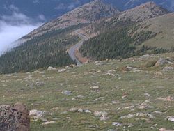
in Colorado's Front Range
, US 34 follows the North Fork Colorado River through Kawuneeche Valley. It passes over Milner Pass
and reaches the Alpine Visitor Center
. Then it continues east, passing its highest point at 12,183 feet near the Gore Range
. It exits the park at US 36
at Deer Ridge Junction.
US 34 here is the highest continuous highway in the United States.
as Eisenhower Boulevard, has a business route and enters Loveland
, becoming a four-lane expressway. Here, it intersects I-25
and U.S. Route 287
.
, it passes by U.S. Route 85
in a complex interchange and U.S. 34 Business, and crosses the South Platte River
. It also has an interchange with SH 257
. From here, it is no longer an expressway. It intersects CO 144
and CO 39
, then joins I-76 at Wiggins
. It leaves, and follows the North Fork Republican River
east into Nebraska, where it intersects CO 71
, CO 52
, CO 63
, CO 61
, CO 59
, and U.S. Route 385.
!County
!Location
!Mile
!Destination
!Notes
|-
|Grand
|Granby
|0.000
|
|West end of route
|-
|rowspan=7| Larimer
|
|53.758
|
|
|-
|rowspan=3| Estes Park
|60.965
|
|
|-
|61.005
|
|
|-
|62.507
|
|
|-
|rowspan=3| Loveland
|91.924
|
|
|-
|96.250
|
|
|-
|96.250
|
|-
|rowspan=7| Weld
|rowspan=7| Greeley
|102.476
|
|
|-
|102.500
|
|
|-
|102.750
|
|
|-
|110.235
|23rd Avenue
|
|-
|112.594
|
|
|-
|112.851
| – Cheyenne
|
|-
|115.411
|
|
|-
|rowspan=6| Morgan
|
|144.470
|
|
|-
|
|149.164
|
|
|-
|bgcolor=#ddffdd|
|bgcolor=#ddffdd|149.345
|bgcolor=#ddffdd|
|bgcolor=#ddffdd|Western end of I-76 overlap
|-
|bgcolor=#ddffdd|
|bgcolor=#ddffdd|159.221
|bgcolor=#ddffdd|
|bgcolor=#ddffdd|Eastern end of I-76 overlap
|-
|Fort Morgan
|162.962
|
|
|-
|Brush
|172.414
| – Kimball
, Last Chance
|
|-
|rowspan=2| Washington
|Akron
|196.336
|
|
|-
|Otis
|209.305
|
|
|-
|rowspan=3| Yuma
|Yuma
|223.345
|
|
|-
|Wray
|249.931
|
|
|-
|
|259.529
|
|East end of route in Colorado
|-
, Colorado
. Both of its termini are at US 34. The business route splits from the main route east of Deer Ridge Junction, where U.S. Route 36
begins, in the western city limits of Estes Park. At Moraine Avenue, It joins US 36
in downtown Estes Park. It returns to US 34 after about 1.7 miles (2.7 km) at Elkhorn Avenue. The business route was established in 1964.
The entire route is located in Larimer County
.
{|class=wikitable
!Location
!Mile
!Destination
!Notes
|-
|rowspan=3|Estes Park
|0.000
| US 34
US 34
|West end of bypass
|-
|1.306
|
|Joins US 36
|-
|1.690
| US 34 with
|East end of bypass
|-
U.S. Route 34
U.S. Route 34 is an east–west United States highway that runs for 1,122 miles from north-central Colorado to the western suburbs of Chicago. Through Rocky Mountain National Park it is known as the Trail Ridge Road where it reaches 12,183 ft , making it the highest paved through highway in...
. Its west end is at U.S. Route 40
U.S. Route 40
U.S. Route 40 is an east–west United States highway. As with most routes whose numbers end in a zero, U.S. 40 once traversed the entire United States. It is one of the original 1920s U.S. Highways, and its first termini were San Francisco, California, and Atlantic City, New Jersey...
in Granby
Granby, Colorado
The Town of Granby is a Statutory Town that is the most populous town in Grand County, Colorado, United States. Granby is situated along U.S. Highway 40 in Middle Park about west of Denver, Colorado, southwest of Rocky Mountain National Park...
and its east end is at the Nebraska
U.S. Route 34 in Nebraska
In the U.S. state of Nebraska, U.S. Highway 34 is a highway which goes between the Colorado border west of Haigler to the Iowa border east of Plattsmouth. Between Culbertson and Hastings, U.S. 34 overlaps U.S. Highway 6. From Grand Island to Lincoln, U.S. 34 has been replaced by Interstate 80 as a...
border east of Laird, Colorado
Laird, Colorado
Laird is a census-designated place in Yuma County, Colorado, United States. The population as of the 2010 Census was 47.The U.S. Post Office at Wray now serves Laird postal addresses....
.
Route description
Granby to Rocky Mountain National Park
The route begins in GranbyGranby, Colorado
The Town of Granby is a Statutory Town that is the most populous town in Grand County, Colorado, United States. Granby is situated along U.S. Highway 40 in Middle Park about west of Denver, Colorado, southwest of Rocky Mountain National Park...
at US 40
U.S. Route 40
U.S. Route 40 is an east–west United States highway. As with most routes whose numbers end in a zero, U.S. 40 once traversed the entire United States. It is one of the original 1920s U.S. Highways, and its first termini were San Francisco, California, and Atlantic City, New Jersey...
. It then follows the Colorado River
Colorado River
The Colorado River , is a river in the Southwestern United States and northwestern Mexico, approximately long, draining a part of the arid regions on the western slope of the Rocky Mountains. The watershed of the Colorado River covers in parts of seven U.S. states and two Mexican states...
Valley near Granby Lake and enters Arapaho National Recreational Area.
Trail Ridge Road
After entering Rocky Mountain National ParkRocky Mountain National Park
Rocky Mountain National Park is a national park located in the north-central region of the U.S. state of Colorado.It features majestic mountain views, a variety of wildlife, varied climates and environments—from wooded forests to mountain tundra—and easy access to back-country trails...
in Colorado's Front Range
Front Range
The Front Range is a mountain range of the Southern Rocky Mountains of North America located in the north-central portion of the U.S. State of Colorado and southeastern portion of the U.S. State of Wyoming. It is the first mountain range encountered moving west along the 40th parallel north across...
, US 34 follows the North Fork Colorado River through Kawuneeche Valley. It passes over Milner Pass
Milner Pass
Milner Pass, elevation is a mountain pass in the Rocky Mountains of northern Colorado in the United States. It is located on the continental divide in the Front Range, within Rocky Mountain National Park, along the boundary between Larimer and Grand counties. The pass provides the passage over the...
and reaches the Alpine Visitor Center
Alpine Visitor Center
Rocky Mountain National Park's Alpine Visitor Center is located at 11,796 feet above sea level at Fall River Pass, about two miles north of the highest point on Trail Ridge Road in the U.S. state of Colorado. The Alpine Visitor's Center includes restrooms, a restaurant and an information and gift...
. Then it continues east, passing its highest point at 12,183 feet near the Gore Range
Gore Range
The Gore Range is a mountain range in the Rocky Mountains of north central Colorado in the United States. The range runs for approximately 60 miles northwest-to-southeast, through western Grand and Summit counties, and eastern Routt and Eagle counties...
. It exits the park at US 36
U.S. Route 36
U.S. Route 36 is an east–west United States highway that runs for from Rocky Mountain National Park, Colorado to Uhrichsville, Ohio. The highway's western terminus is at Deer Ridge Junction, an intersection in Rocky Mountain National Park, Colorado, where it meets U.S. Route 34. Its eastern...
at Deer Ridge Junction.
US 34 here is the highest continuous highway in the United States.
Estes Park to Loveland
From here, it passes by Estes ParkEstes Park, Colorado
Estes Park is a town in Larimer County, Colorado, United States. A popular summer resort and the location of the headquarters for Rocky Mountain National Park, Estes Park lies along the Big Thompson River. Estes Park had a population of 5,858 at the 2010 census...
as Eisenhower Boulevard, has a business route and enters Loveland
Loveland, Colorado
Loveland is a Home Rule Municipality that is the second most populous city in Larimer County, Colorado, United States. Loveland is situated north of the Colorado State Capitol in Denver. Loveland is the 14th most populous city in Colorado. The United States Census Bureau that in 2010 the...
, becoming a four-lane expressway. Here, it intersects I-25
Interstate 25 in Colorado
In the U.S. state of Colorado, Interstate 25 follows the north–south corridor through Colorado Springs and Denver. It replaced U.S. Highway 87 and most of U.S. Highway 85 for through traffic....
and U.S. Route 287
U.S. Route 287
U.S. Route 287 is a north–south United States highway. It is long. It serves as the major truck route between the Texas cities of Fort Worth and Amarillo...
.
Greeley to Nebraska border
At GreeleyGreeley, Colorado
The City of Greeley is a Home Rule Municipality that is the county seat and the most populous city of Weld County, Colorado, United States. Greeley is located in the region known as Northern Colorado. Greeley is situated north-northeast of the Colorado State Capitol in Denver. According to the...
, it passes by U.S. Route 85
U.S. Route 85
U.S. Route 85 is a north–south United States highway that runs for in the Mountain - Northern Plains states of the United States. The southern terminus of the route is at the United States-Mexico border in El Paso, Texas, connecting with Mexican Federal Highway 45...
in a complex interchange and U.S. 34 Business, and crosses the South Platte River
South Platte River
The South Platte River is one of the two principal tributaries of the Platte River and itself a major river of the American Midwest and the American Southwest/Mountain West, located in the U.S. states of Colorado and Nebraska...
. It also has an interchange with SH 257
Colorado State Highway 257
Colorado State Highway 257 is a 18.478-mile long highway in Colorado's Front Range. It is located entirely in Weld County. Its western end is at SH 60 and its eastern end is at SH 14.-Route description:...
. From here, it is no longer an expressway. It intersects CO 144
Colorado State Highway 144
State Highway 144 is a long state highway in northeastern Colorado.-Route description:SH 144 begins in the west at Interstate 76 and proceeds initially to the north; after , the road crosses U.S. Highway 34. After another , the route crosses the South Platte River and begins to curve in a broad...
and CO 39
Colorado State Highway 39
-Route description:SH 39 runs , starting at a junction with I-76 near Wiggins, going north across the South Platte River and ending at a junction with SH 144 near Jackson Lake State Park.-Major intersections:The entire route is in Morgan County....
, then joins I-76 at Wiggins
Wiggins, Colorado
Wiggins is a Statutory village in Morgan County, Colorado, United States. The population was 001 at the 2000 census.The community was established in 1882 as the Burlington railroad depot of Corona. Around 1900, Corona was renamed in honor of Oliver P. Wiggins, who served as a guide and scout for...
. It leaves, and follows the North Fork Republican River
North Fork Republican River
The North Fork Republican River is a tributary of the Republican River. It flows eastward from a source in Yuma County, Colorado to just north of Hagler in Dundy County, Nebraska...
east into Nebraska, where it intersects CO 71
Colorado State Highway 71
State Highway 71 is a long state highway passing several other highways in northern and central Colorado. The route runs south from the Nebraska border to La Junta.-Route description:...
, CO 52
Colorado State Highway 52
State Highway 52 is a long state highway in northeastern Colorado.-Route description:SH 52 begins near Niwot, winding east from its western terminus past US 287 to I-25, near the towns of Dacono, Frederick, and Firestone The highway has interchanges with US 85, then continues east to I-76 in Hudson...
, CO 63
Colorado State Highway 63
State Highway 63 is a long state highway in northeastern Colorado.-Route description:SH 63 begins in the south at a junction with U.S. Highway 36 at Anton and proceeds north through remote, sparsely populated land for roughly before reaching a junction with U.S. Highway 34 at Akron...
, CO 61
Colorado State Highway 61
State Highway 61 is a long state highway in northeastern Colorado.-Route description:SH 61 begins at an at-grade intersection with U.S. Route 34 at the south side of Otis. It begins straight northward through town, in which roads are laid out in a grid-like pattern. The road then exits the town,...
, CO 59
Colorado State Highway 59
State Highway 59 is a long state highway in eastern Colorado.-Route description:SH 59 begins in the south at a junction with U.S. Highway 40 in Kit Carson. From there, the road proceeds northward for before intersecting Interstate 70 at that highway's exit 405 just south of the Seibert city...
, and U.S. Route 385.
History
Parts of the route were originally designated as US 38. US 34 was extended into Colorado in 1939.Major intersections
{| class=wikitable!County
!Location
!Mile
!Destination
!Notes
|-
|Grand
Grand County, Colorado
Grand County is the 21st largest of the 64 counties of the State of Colorado of the United States. The county population was 12,442 at U.S. Census 2000...
|Granby
Granby, Colorado
The Town of Granby is a Statutory Town that is the most populous town in Grand County, Colorado, United States. Granby is situated along U.S. Highway 40 in Middle Park about west of Denver, Colorado, southwest of Rocky Mountain National Park...
|0.000
|
|West end of route
|-
|rowspan=7| Larimer
Larimer County, Colorado
Larimer County is the seventh most populous and the ninth most extensive of the 64 counties of the State of Colorado of the United States. The county is located at the northern end of the Front Range, at the edge of the Colorado Eastern Plains along the border with Wyoming...
|
|53.758
|
|
|-
|rowspan=3| Estes Park
Estes Park, Colorado
Estes Park is a town in Larimer County, Colorado, United States. A popular summer resort and the location of the headquarters for Rocky Mountain National Park, Estes Park lies along the Big Thompson River. Estes Park had a population of 5,858 at the 2010 census...
|60.965
|
|
|-
|61.005
|
|
|-
|62.507
|
|
|-
|rowspan=3| Loveland
Loveland, Colorado
Loveland is a Home Rule Municipality that is the second most populous city in Larimer County, Colorado, United States. Loveland is situated north of the Colorado State Capitol in Denver. Loveland is the 14th most populous city in Colorado. The United States Census Bureau that in 2010 the...
|91.924
|
|
|-
|96.250
|
|
|-
|96.250
|
|-
|rowspan=7| Weld
Weld County, Colorado
As of the census of 2000, there were 180,936 people, 63,247 households, and 45,221 families residing in the county. The population density was 45 people per square mile . There were 66,194 housing units at an average density of 17 per square mile...
|rowspan=7| Greeley
Greeley, Colorado
The City of Greeley is a Home Rule Municipality that is the county seat and the most populous city of Weld County, Colorado, United States. Greeley is located in the region known as Northern Colorado. Greeley is situated north-northeast of the Colorado State Capitol in Denver. According to the...
|102.476
|
|
|-
|102.500
|
|
|-
|102.750
|
|
|-
|110.235
|23rd Avenue
|
|-
|112.594
|
|
|-
|112.851
| – Cheyenne
Cheyenne, Wyoming
Cheyenne is the capital and most populous city of the U.S. state of Wyoming and the county seat of Laramie County. It is the principal city of the Cheyenne, Wyoming, Metropolitan Statistical Area which encompasses all of Laramie County. The population is 59,466 at the 2010 census. Cheyenne is the...
|
|-
|115.411
|
|
|-
|rowspan=6| Morgan
Morgan County, Colorado
Morgan County is the 18th most populous of the 64 counties of the State of Colorado of the United States. The county was named after old Fort Morgan, which in turn was named in honor of Colonel Christopher A. Morgan. The county population was 27,171 at U.S. Census 2000. The county seat is the...
|
|144.470
|
|
|-
|
|149.164
|
|
|-
|bgcolor=#ddffdd|
|bgcolor=#ddffdd|149.345
|bgcolor=#ddffdd|
|bgcolor=#ddffdd|Western end of I-76 overlap
|-
|bgcolor=#ddffdd|
|bgcolor=#ddffdd|159.221
|bgcolor=#ddffdd|
|bgcolor=#ddffdd|Eastern end of I-76 overlap
|-
|Fort Morgan
Fort Morgan, Colorado
The City of Fort Morgan is a Home Rule Municipality that is the county seat and the most populous city of Morgan County, Colorado, United States. The United States Census Bureau estimated that the city population was 10,844 in 2005.-History:...
|162.962
|
|
|-
|Brush
Brush, Colorado
The City of Brush is a Statutory City located in Morgan County, Colorado, United States. The population was 5,117 at the 2000 census.-Geography:Brush is located at ....
|172.414
| – Kimball
Kimball, Nebraska
Kimball is a city in Kimball County, Nebraska, United States. The population was 2,559 at the 2000 census. It is the county seat of Kimball County.-Geography:Kimball is located at , in the southwestern Panhandle....
, Last Chance
Last Chance, Colorado
Last Chance is an unincorporated community in Washington County, Colorado, United States. Last Chance is situated at the intersection of U.S. Highway 36 and State Highway 71 in a sparsely populated area of eastern Colorado. The town was supposedly so named because it was once the only place for...
|
|-
|rowspan=2| Washington
Washington County, Colorado
Washington County is the 12th most extensive of the 64 counties of the State of Colorado of the United States. The county population was 4,926 at U.S. Census 2000. The county was named in honor of the United States President George Washington...
|Akron
Akron, Colorado
The Town of Akron is a Statutory Town that is the county seat and the most populous town of Washington County, in the U.S. State of Colorado. The town population was 1,702 at the U.S. Census 2010.- Geography :...
|196.336
|
|
|-
|Otis
Otis, Colorado
Otis is a Statutory Town in Washington County, Colorado, United States. The population was 534 at the 2000 census.-History:Otis was established in 1883 as a stop on the Burlington rail line...
|209.305
|
|
|-
|rowspan=3| Yuma
Yuma County, Colorado
Yuma County is the 14th most extensive of the 64 counties of the State of Colorado of the United States. The county population was 9,841 at U.S. Census 2000...
|Yuma
Yuma, Colorado
The City of Yuma is a Home Rule Municipality that is the most populous city in Yuma County, Colorado, United States. The population was 3,285 at the 2000 census.-Geography:...
|223.345
|
|
|-
|Wray
Wray, Colorado
The City of Wray is a Home Rule Municipality that is the county seat of Yuma County, Colorado, United States. The population was 2,187 at the U.S. Census 2000. The school mascot is the Eagles for high school and Eaglets in the lower grades. School colors are purple and white and the Eaglets are...
|249.931
|
|
|-
|
|259.529
|
|East end of route in Colorado
|-
Estes Park business loop
U.S. Route 34 Business serves Estes ParkEstes Park, Colorado
Estes Park is a town in Larimer County, Colorado, United States. A popular summer resort and the location of the headquarters for Rocky Mountain National Park, Estes Park lies along the Big Thompson River. Estes Park had a population of 5,858 at the 2010 census...
, Colorado
Colorado
Colorado is a U.S. state that encompasses much of the Rocky Mountains as well as the northeastern portion of the Colorado Plateau and the western edge of the Great Plains...
. Both of its termini are at US 34. The business route splits from the main route east of Deer Ridge Junction, where U.S. Route 36
U.S. Route 36
U.S. Route 36 is an east–west United States highway that runs for from Rocky Mountain National Park, Colorado to Uhrichsville, Ohio. The highway's western terminus is at Deer Ridge Junction, an intersection in Rocky Mountain National Park, Colorado, where it meets U.S. Route 34. Its eastern...
begins, in the western city limits of Estes Park. At Moraine Avenue, It joins US 36
U.S. Route 36 in Colorado
U.S. Route 36 is a major east–west route in the U.S. state of Colorado, extending from Rocky Mountain National Park to the Kansas state line.-Route description:...
in downtown Estes Park. It returns to US 34 after about 1.7 miles (2.7 km) at Elkhorn Avenue. The business route was established in 1964.
The entire route is located in Larimer County
Larimer County, Colorado
Larimer County is the seventh most populous and the ninth most extensive of the 64 counties of the State of Colorado of the United States. The county is located at the northern end of the Front Range, at the edge of the Colorado Eastern Plains along the border with Wyoming...
.
{|class=wikitable
!Location
!Mile
!Destination
!Notes
|-
|rowspan=3|Estes Park
Estes Park, Colorado
Estes Park is a town in Larimer County, Colorado, United States. A popular summer resort and the location of the headquarters for Rocky Mountain National Park, Estes Park lies along the Big Thompson River. Estes Park had a population of 5,858 at the 2010 census...
|0.000
|
|West end of bypass
|-
|1.306
|
|Joins US 36
|-
|1.690
|
|East end of bypass
|-