

U.S. Route 285
Encyclopedia
U.S. Route 285 is a north–south United States highway, running 845 miles (1,260 km) through the states of Texas
, New Mexico
and Colorado
. The highway's northern terminus is in Denver, Colorado
, at exit 201 on Interstate 25
. Its southern terminus is in Sanderson, Texas
at an intersection with U.S. Route 90
. It has always had an endpoint in Denver, Colorado
, though what is now the northern terminus was once the route's southern end. Trucking makes up a large portion of the route's traffic, but for the most part, the road is used for local travel from one town to the next.
The route is a secondary route of US 85, though its parent route has been largely replaced by Interstate 25
. It crosses a sibling route, US 385 in Fort Stockton, Texas
.
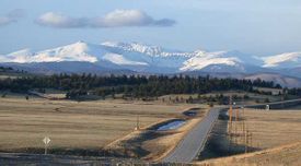
The northern section of the route, from Santa Fe, New Mexico
to Denver, Colorado
traverses mountainous and rocky terrain; with that in mind, anyone using the road should check weather conditions during the winter months.
As of January 2007 the road is under construction between Espanola
and Santa Fe, New Mexico
, as part of a long term project to upgrade that section of the highway to a limited access thoroughfare.
|TX
|170
|274
|-
|NM
|402
|647
|-
|CO
|263
|423
|-
|Total
|835
|1344
|}
 US 285 runs for a few miles through the Denver metro area as Hampden Avenue
then begins to climb into the Rocky Mountains
, mostly following the route of the original narrow gauge transcontinental railroad
, skirting the south side of the Mount Evans
massif. Once west of Mount Evans, the highway winds its way over Kenosha Pass
, elevation 10001 feet (3,048.3 m), into the high-altitude South Park
basin of Colorado
.
Partway across the South Park, it serves the town of Como
, which still houses one of the few remaining narrow gauge roundhouse
s. The old transcontinental railroad breaks away from US 285 at this point, going northwest over Boreas Pass
en route to Breckenridge, the historically rich gold fields of Leadville, and eventually California
. US 285, meanwhile, continues across the valley to the southwest, leaving the South Park basin as it climbs over Trout Creek Pass, elevation 9346 feet (2,848.7 m), and then drops into the Upper Arkansas River
Valley, with a view of Mount Princeton
.
Once the highway hits the Arkansas River Valley floor, it takes a sharp turn south, just missing the small town of Buena Vista
to the north. As US 285 turns south, it brushes Salida
, climbs over Poncha Pass
, elevation 9012 feet (2,746.9 m), then enters the northern end of the San Luis Valley
.
On March 14, 2008 both houses of the Colorado legislature, in a unanimous vote, named the section between Kenosha Pass and C-470 the "Ralph Carr Memorial Highway." http://www.politicswest.com/21773/house_names_road_after_courageous_gov_ralph_carrhttp://www.asiaxpress.com/Articles/2008/mar/carr_highway/1.html
the highway continues mostly straight south through the San Luis valley into New Mexico
. At the south end of the valley, the road goes through the village of Tres Piedras, New Mexico and crosses US 64. Immediately after, it begins the long descent off the Colorado Plateau, passing through Ojo Caliente
and then crossing the Rio Chama. It then merges with US 84 in Chamita, NM.
The combined road continues south along the course of the Rio Chama until reaches Espanola
and its surroundings, which contains some of the oldest Spanish settlements in the United States. Continuing south, the road becomes a major highway, and the single artery connecting the Espanola valley to Santa Fe
.
After passing through Santa Fe, the highway joins I-25 for several miles on an eastward path through the foothills of the Sangre De Cristo mountains, until 285 branches south on its own into the eastern plains of New Mexico
. It passes south through Roswell
and Carlsbad
and then leaves the state, entering Texas
going towards Pecos
.
, 285 meets I-20 at Pecos
. Further along, it crosses I-10
at Fort Stockton
and finally reaches its southern terminus at US 90 in Sanderson
.
Texas
Texas is the second largest U.S. state by both area and population, and the largest state by area in the contiguous United States.The name, based on the Caddo word "Tejas" meaning "friends" or "allies", was applied by the Spanish to the Caddo themselves and to the region of their settlement in...
, New Mexico
New Mexico
New Mexico is a state located in the southwest and western regions of the United States. New Mexico is also usually considered one of the Mountain States. With a population density of 16 per square mile, New Mexico is the sixth-most sparsely inhabited U.S...
and Colorado
Colorado
Colorado is a U.S. state that encompasses much of the Rocky Mountains as well as the northeastern portion of the Colorado Plateau and the western edge of the Great Plains...
. The highway's northern terminus is in Denver, Colorado
Denver, Colorado
The City and County of Denver is the capital and the most populous city of the U.S. state of Colorado. Denver is a consolidated city-county, located in the South Platte River Valley on the western edge of the High Plains just east of the Front Range of the Rocky Mountains...
, at exit 201 on Interstate 25
Interstate 25
Interstate 25 is an Interstate Highway in the western United States. It is primarily a north–south highway. I-25 stretches from Interstate 10 at Las Cruces, New Mexico, , to Interstate 90 in Buffalo, Wyoming, .Interstate 25 is the main north–south expressway through...
. Its southern terminus is in Sanderson, Texas
Sanderson, Texas
Sanderson is a census-designated place in and the county seat of Terrell County, Texas, United States. The population was 861 at the 2000 census. Sanderson was created in 1882 as a part of neighboring Pecos County...
at an intersection with U.S. Route 90
U.S. Route 90
U.S. Route 90 is an east–west United States highway. Despite the "0" in its route number, U.S. 90 never was a full coast-to-coast route; it has always ended at Van Horn, Texas. A short-lived northward extension to U.S...
. It has always had an endpoint in Denver, Colorado
Denver, Colorado
The City and County of Denver is the capital and the most populous city of the U.S. state of Colorado. Denver is a consolidated city-county, located in the South Platte River Valley on the western edge of the High Plains just east of the Front Range of the Rocky Mountains...
, though what is now the northern terminus was once the route's southern end. Trucking makes up a large portion of the route's traffic, but for the most part, the road is used for local travel from one town to the next.
The route is a secondary route of US 85, though its parent route has been largely replaced by Interstate 25
Interstate 25
Interstate 25 is an Interstate Highway in the western United States. It is primarily a north–south highway. I-25 stretches from Interstate 10 at Las Cruces, New Mexico, , to Interstate 90 in Buffalo, Wyoming, .Interstate 25 is the main north–south expressway through...
. It crosses a sibling route, US 385 in Fort Stockton, Texas
Fort Stockton, Texas
Fort Stockton is a city in Pecos County, Texas, United States. The population was 7,846 at the 2000 census. It is the county seat of Pecos County.-Geography:Fort Stockton is located at ....
.
The northern section of the route, from Santa Fe, New Mexico
Santa Fe, New Mexico
Santa Fe is the capital of the U.S. state of New Mexico. It is the fourth-largest city in the state and is the seat of . Santa Fe had a population of 67,947 in the 2010 census...
to Denver, Colorado
Denver, Colorado
The City and County of Denver is the capital and the most populous city of the U.S. state of Colorado. Denver is a consolidated city-county, located in the South Platte River Valley on the western edge of the High Plains just east of the Front Range of the Rocky Mountains...
traverses mountainous and rocky terrain; with that in mind, anyone using the road should check weather conditions during the winter months.
As of January 2007 the road is under construction between Espanola
Española, New Mexico
Española also known as Espanola , is a city primarily in Rio Arriba County, New Mexico, in the United States. A portion of the central and eastern section of the city is in Santa Fe County. Española was founded in 1880 as a railroad village, incorporated as a city in 1925. The city is situated in...
and Santa Fe, New Mexico
Santa Fe, New Mexico
Santa Fe is the capital of the U.S. state of New Mexico. It is the fourth-largest city in the state and is the seat of . Santa Fe had a population of 67,947 in the 2010 census...
, as part of a long term project to upgrade that section of the highway to a limited access thoroughfare.
Route description
|-|TX
|170
|274
|-
|NM
|402
|647
|-
|CO
|263
|423
|-
|Total
|835
|1344
|}
Colorado
Colorado State Highway 30
Colorado State Highway 30, alternatively known as Hampden Avenue, is a state route in the independent city of Denver and Arapahoe County. Its west end is at Interstate 25 and US 285 in Denver and its east end is at Quincy Avenue east of Aurora....
then begins to climb into the Rocky Mountains
Rocky Mountains
The Rocky Mountains are a major mountain range in western North America. The Rocky Mountains stretch more than from the northernmost part of British Columbia, in western Canada, to New Mexico, in the southwestern United States...
, mostly following the route of the original narrow gauge transcontinental railroad
Transcontinental railroad
A transcontinental railroad is a contiguous network of railroad trackage that crosses a continental land mass with terminals at different oceans or continental borders. Such networks can be via the tracks of either a single railroad, or over those owned or controlled by multiple railway companies...
, skirting the south side of the Mount Evans
Mount Evans
Mount Evans is a mountain in the Front Range region of the Rocky Mountains, in Clear Creek County, Colorado. It is one of 54 fourteeners in Colorado, and the closest fourteener to Denver...
massif. Once west of Mount Evans, the highway winds its way over Kenosha Pass
Kenosha Pass
Kenosha Pass, elevation , is a high mountain pass located in the Rocky Mountains of central Colorado in the United States.The pass is located in the Rocky Mountains southwest of Denver, Colorado, just northeast of the town of Fairplay, Colorado...
, elevation 10001 feet (3,048.3 m), into the high-altitude South Park
South Park (Colorado basin)
South Park is a high intermontane grassland basin, approximately 10,000 ft in elevation, in the Rocky Mountains of central Colorado. It encompasses approximately 1,000 square miles around the headwaters of the South Platte River in Park County approximately 60 mi southwest of Denver...
basin of Colorado
Colorado
Colorado is a U.S. state that encompasses much of the Rocky Mountains as well as the northeastern portion of the Colorado Plateau and the western edge of the Great Plains...
.
Partway across the South Park, it serves the town of Como
Como, Colorado
Como is an unincorporated town and a U.S. Post Office in Park County, Colorado, United States. The Como Post Office has the ZIP Code 80432.Located at the northern end of South Park, the town is a historic mining settlement founded during the Pike's Peak Gold Rush in 1859. It sits approximately...
, which still houses one of the few remaining narrow gauge roundhouse
Roundhouse
A roundhouse is a building used by railroads for servicing locomotives. Roundhouses are large, circular or semicircular structures that were traditionally located surrounding or adjacent to turntables...
s. The old transcontinental railroad breaks away from US 285 at this point, going northwest over Boreas Pass
Boreas Pass
Boreas Pass, elevation , is a high mountain pass in the Rocky Mountains of central Colorado in the United States. The pass is located on the continental divide, at the crest of the Front Range along the border between Park and Summit counties...
en route to Breckenridge, the historically rich gold fields of Leadville, and eventually California
California
California is a state located on the West Coast of the United States. It is by far the most populous U.S. state, and the third-largest by land area...
. US 285, meanwhile, continues across the valley to the southwest, leaving the South Park basin as it climbs over Trout Creek Pass, elevation 9346 feet (2,848.7 m), and then drops into the Upper Arkansas River
Arkansas River
The Arkansas River is a major tributary of the Mississippi River. The Arkansas generally flows to the east and southeast as it traverses the U.S. states of Colorado, Kansas, Oklahoma, and Arkansas. The river's initial basin starts in the Western United States in Colorado, specifically the Arkansas...
Valley, with a view of Mount Princeton
Mount Princeton
Mount Princeton is one of the fourteeners of the US state of Colorado. It lies in the Collegiate Peaks, in the central part of the Sawatch Range, just west of the Arkansas River. While not one of the highest peaks of the Sawatch, it is one of the most dramatic, as it rises over 6,500 feet from the...
.
Once the highway hits the Arkansas River Valley floor, it takes a sharp turn south, just missing the small town of Buena Vista
Buena Vista, Colorado
Buena Vista is a Statutory Town in Chaffee County, Colorado, United States. The population was 2,195 at the 2000 census.Buena Vista is located in central Colorado roughly midway between Salida and Leadville in the Upper Arkansas River Valley at an elevation of . The area between Buena Vista and...
to the north. As US 285 turns south, it brushes Salida
Salida, Colorado
The City of Salida is a Statutory City that is the county seat and most populous city of Chaffee County, Colorado, United States. The population was 5,504 at the U.S. Census 2000.-History:800px|thumb|left| Panoramic View of Salida, 1910...
, climbs over Poncha Pass
Poncha Pass
Poncha Pass is a mountain pass in South-Central Colorado . It lies between the San Luis Valley to the south and the valley of the Arkansas River to the north, and is one of the lowest mountain passes in the state . It is in the saddle between the Sangre de Cristo Range, lying to the southeast, and...
, elevation 9012 feet (2,746.9 m), then enters the northern end of the San Luis Valley
San Luis Valley
The San Luis Valley is an extensive alpine valley in the U.S. states of Colorado and New Mexico covering approximately and sitting at an average elevation of above sea level. The valley sits atop the Rio Grande Rift and is drained to the south by the Rio Grande River, which rises in the San Juan...
.
On March 14, 2008 both houses of the Colorado legislature, in a unanimous vote, named the section between Kenosha Pass and C-470 the "Ralph Carr Memorial Highway." http://www.politicswest.com/21773/house_names_road_after_courageous_gov_ralph_carrhttp://www.asiaxpress.com/Articles/2008/mar/carr_highway/1.html
New Mexico
Leaving ColoradoColorado
Colorado is a U.S. state that encompasses much of the Rocky Mountains as well as the northeastern portion of the Colorado Plateau and the western edge of the Great Plains...
the highway continues mostly straight south through the San Luis valley into New Mexico
New Mexico
New Mexico is a state located in the southwest and western regions of the United States. New Mexico is also usually considered one of the Mountain States. With a population density of 16 per square mile, New Mexico is the sixth-most sparsely inhabited U.S...
. At the south end of the valley, the road goes through the village of Tres Piedras, New Mexico and crosses US 64. Immediately after, it begins the long descent off the Colorado Plateau, passing through Ojo Caliente
Ojo Caliente, New Mexico
Ojo Caliente is a small unincorporated community in Taos County, New Mexico, United States. It lies along U.S. Route 285 near the Rio Grande. The state capital, Santa Fe lies south of Ojo Caliente, which sits between Espanola and Taos, approximately 50 miles southeast of Ghost Ranch. The community...
and then crossing the Rio Chama. It then merges with US 84 in Chamita, NM.
The combined road continues south along the course of the Rio Chama until reaches Espanola
Española, New Mexico
Española also known as Espanola , is a city primarily in Rio Arriba County, New Mexico, in the United States. A portion of the central and eastern section of the city is in Santa Fe County. Española was founded in 1880 as a railroad village, incorporated as a city in 1925. The city is situated in...
and its surroundings, which contains some of the oldest Spanish settlements in the United States. Continuing south, the road becomes a major highway, and the single artery connecting the Espanola valley to Santa Fe
Santa Fe, New Mexico
Santa Fe is the capital of the U.S. state of New Mexico. It is the fourth-largest city in the state and is the seat of . Santa Fe had a population of 67,947 in the 2010 census...
.
After passing through Santa Fe, the highway joins I-25 for several miles on an eastward path through the foothills of the Sangre De Cristo mountains, until 285 branches south on its own into the eastern plains of New Mexico
New Mexico
New Mexico is a state located in the southwest and western regions of the United States. New Mexico is also usually considered one of the Mountain States. With a population density of 16 per square mile, New Mexico is the sixth-most sparsely inhabited U.S...
. It passes south through Roswell
Roswell, New Mexico
Roswell is a city in and the county seat of Chaves County in the southeastern quarter of the state of New Mexico, United States. The population was 48,366 at the 2010 census. It is a center for irrigation farming, dairying, ranching, manufacturing, distribution, and petroleum production. It is also...
and Carlsbad
Carlsbad, New Mexico
Carlsbad is a city in and the county seat of Eddy County, New Mexico, in the United States. As of the 2010 census, the city population was 26,138. Carlsbad is the center of the designated micropolitan area of Carlsbad-Artesia, which has a total population of 55,435...
and then leaves the state, entering Texas
Texas
Texas is the second largest U.S. state by both area and population, and the largest state by area in the contiguous United States.The name, based on the Caddo word "Tejas" meaning "friends" or "allies", was applied by the Spanish to the Caddo themselves and to the region of their settlement in...
going towards Pecos
Pecos, Texas
Pecos is the largest city in and the county seat of Reeves County, Texas, United States. It is situated in the river valley on the west bank of the Pecos River at the eastern edge of the Chihuahuan Desert and the Trans-Pecos region of west Texas and near the southern border of New Mexico...
.
Texas
After leaving New MexicoNew Mexico
New Mexico is a state located in the southwest and western regions of the United States. New Mexico is also usually considered one of the Mountain States. With a population density of 16 per square mile, New Mexico is the sixth-most sparsely inhabited U.S...
, 285 meets I-20 at Pecos
Pecos, Texas
Pecos is the largest city in and the county seat of Reeves County, Texas, United States. It is situated in the river valley on the west bank of the Pecos River at the eastern edge of the Chihuahuan Desert and the Trans-Pecos region of west Texas and near the southern border of New Mexico...
. Further along, it crosses I-10
Interstate 10 in Texas
Interstate 10 is the major east–west Interstate Highway in the Southern United States. In the U.S. state of Texas, it runs east from El Paso, near the border with New Mexico, through San Antonio and Houston to the border with Louisiana in Orange, Texas....
at Fort Stockton
Fort Stockton, Texas
Fort Stockton is a city in Pecos County, Texas, United States. The population was 7,846 at the 2000 census. It is the county seat of Pecos County.-Geography:Fort Stockton is located at ....
and finally reaches its southern terminus at US 90 in Sanderson
Sanderson, Texas
Sanderson is a census-designated place in and the county seat of Terrell County, Texas, United States. The population was 861 at the 2000 census. Sanderson was created in 1882 as a part of neighboring Pecos County...
.