

U.S. Route 197
Encyclopedia
U.S. Route 197 is a north–south U.S. Route
serving Central Oregon
and the Columbia Gorge. The route was added in the 1950s. The southern terminus of US 197 is at an intersection with U.S. Route 97
west of Shaniko, Oregon
. From US 97, US 197 traverses Wasco County
and the cities of Maupin
, Tygh Valley
, Dufur
, and The Dalles
before reaching the Oregon
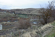
Washington border. From the border, US 197 goes over The Dalles Bridge
and then continues north to end at SR 14 north of Dallesport, Washington
.
|OR
|| 60.72 ||
|-
|WA || 3.18 ||
|-
|Total || 63.90 || 102.84
|}
 The Oregon
section of US 197 is designated as part of The Dalles-California Highway No. 4 (see Oregon highways and routes).
 Branching from US 97
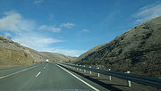
south of Shaniko, US 197 runs northwest, first climbing to the Criterion Summit
at over 3300 feet (1,005.8 m) and dropping to about 900 feet (274.3 m) to the Deschutes River at Maupin
in a dramatic winding river crossing. About two miles (3 km) west of Maupin, US 197 intersects Oregon Route 216
(Wapinitia Highway) and overlaps it north to Tygh Valley
. At Tygh Valley, OR 216, now known as the Sherars Bridge Highway, turns east to Sherar's Bridge and Grass Valley
.
Remaining west of the Deschutes River, US 197 crests the Tygh Grade Summit
6.5 miles (10.5 km) north of Tygh Valley and then proceeds north down the slope of the Columbia River Gorge
through Dufur
to the city of The Dalles
and thence to The Dalles Bridge
and on to Washington.
 In Washington, US 197 extends for three miles (5 km) from The Dalles Bridge
over the Columbia River
to an intersection with SR 14 near Dallesport
. Although most of the route within the state is little more than a local road, the southernmost portion of US 197 passes by The Dalles Municipal Airport and is the main connector between the airport and the city. The entirety of U.S. 197 within Washington is defined at Washington Revised Code § 47.17.382.
, its current southern terminus, north to U.S. Route 830
and east to US 97
in Maryhill, Washington. The portion from US 830 to US 97 was co-signed with US 830 until 1968, when US 830 was removed from the system and US 197's northern terminus was moved to SR 14, which is the former route of US 830. Even though the section was removed in 1968, the portion of US 197 was not removed from most highway mileage logs until 2006.
United States Numbered Highways
The system of United States Numbered Highways is an integrated system of roads and highways in the United States numbered within a nationwide grid...
serving Central Oregon
Central Oregon
Central Oregon is a geographic region in the U.S. state of Oregon and is traditionally considered to be made up of Deschutes, Jefferson, and Crook counties. Other definitions include larger areas, often encompassing areas to the north towards the Columbia River, eastward towards Burns, or south...
and the Columbia Gorge. The route was added in the 1950s. The southern terminus of US 197 is at an intersection with U.S. Route 97
U.S. Route 97 in Oregon
In the U.S. state of Oregon, U.S. Route 97 is a major north–south United States highway which runs through the state of Oregon . In Oregon, it runs from the Oregon-California border, south of Klamath Falls, to the Oregon-Washington border on the Columbia River, between Biggs Junction, Oregon and...
west of Shaniko, Oregon
Shaniko, Oregon
Shaniko is a city located in Wasco County, Oregon, United States, on U.S. Route 97 and about eight miles north of Antelope. As of the 2000 census, the city had a population of 26—a virtual ghost town whose preservation is being spearheaded by investments from Robert B...
. From US 97, US 197 traverses Wasco County
Wasco County, Oregon
Wasco County is a county located in the U.S. state of Oregon. The county is named for a local tribe of Native Americans, the Wasco, a Chinook tribe who lived on the south side of the Columbia River. In 2010, its population was 25,213...
and the cities of Maupin
Maupin, Oregon
Maupin is a city in Wasco County, Oregon, United States. Located on the Deschutes River, much of the city's economy is related to the river through outdoor activities, such as fishing and rafting...
, Tygh Valley
Tygh Valley, Oregon
* Annual Average High Temperatures: 86 °F 41 °F * Annual Average Low Temperatures 50 °F 26 °F * Highest Recorded Temperature: 110 °F * Lowest Recorded Temperature: -28 °F...
, Dufur
Dufur, Oregon
Dufur is a city in Wasco County, Oregon, United States. The population was 588 at the 2000 census. It is a farming community, with wheat being an important crop, along with tree fruit and grapes....
, and The Dalles
The Dalles, Oregon
The Dalles is the largest city and county seat of Wasco County, Oregon, United States. The name of the city comes from the French word dalle The Dalles is the largest city and county seat of Wasco County, Oregon, United States. The name of the city comes from the French word dalle The Dalles is...
before reaching the Oregon
Oregon
Oregon is a state in the Pacific Northwest region of the United States. It is located on the Pacific coast, with Washington to the north, California to the south, Nevada on the southeast and Idaho to the east. The Columbia and Snake rivers delineate much of Oregon's northern and eastern...
Washington border. From the border, US 197 goes over The Dalles Bridge
The Dalles Bridge
The Dalles Bridge is a steel cantilever truss bridge that spans the Columbia River between The Dalles, Oregon and Dallesport, Washington. It carries the traffic of U.S. Highway 197....
and then continues north to end at SR 14 north of Dallesport, Washington
Dallesport, Washington
Dallesport is a census-designated place in Klickitat County, Washington, United States. The population was 1,202 at the 2010 census.-History:...
.
Oregon
|-|OR
Oregon
Oregon is a state in the Pacific Northwest region of the United States. It is located on the Pacific coast, with Washington to the north, California to the south, Nevada on the southeast and Idaho to the east. The Columbia and Snake rivers delineate much of Oregon's northern and eastern...
|| 60.72 ||
|-
|WA || 3.18 ||
|-
|Total || 63.90 || 102.84
|}
Oregon
Oregon is a state in the Pacific Northwest region of the United States. It is located on the Pacific coast, with Washington to the north, California to the south, Nevada on the southeast and Idaho to the east. The Columbia and Snake rivers delineate much of Oregon's northern and eastern...
section of US 197 is designated as part of The Dalles-California Highway No. 4 (see Oregon highways and routes).
U.S. Route 97 in Oregon
In the U.S. state of Oregon, U.S. Route 97 is a major north–south United States highway which runs through the state of Oregon . In Oregon, it runs from the Oregon-California border, south of Klamath Falls, to the Oregon-Washington border on the Columbia River, between Biggs Junction, Oregon and...
south of Shaniko, US 197 runs northwest, first climbing to the Criterion Summit
Criterion Summit
Criterion Summit is a mountain pass in Oregon traversed by U.S. Route 197.Its location is south of Maupin approximately 3 miles north of the intersection of US 197 with U.S. Route 97....
at over 3300 feet (1,005.8 m) and dropping to about 900 feet (274.3 m) to the Deschutes River at Maupin
Maupin, Oregon
Maupin is a city in Wasco County, Oregon, United States. Located on the Deschutes River, much of the city's economy is related to the river through outdoor activities, such as fishing and rafting...
in a dramatic winding river crossing. About two miles (3 km) west of Maupin, US 197 intersects Oregon Route 216
Oregon Route 216
Oregon Route 216 is an Oregon state highway running from U.S. Route 26 at Warm Springs Junction to U.S. Route 97 in Grass Valley. OR 216 is long and runs east–west.- Route description :...
(Wapinitia Highway) and overlaps it north to Tygh Valley
Tygh Valley, Oregon
* Annual Average High Temperatures: 86 °F 41 °F * Annual Average Low Temperatures 50 °F 26 °F * Highest Recorded Temperature: 110 °F * Lowest Recorded Temperature: -28 °F...
. At Tygh Valley, OR 216, now known as the Sherars Bridge Highway, turns east to Sherar's Bridge and Grass Valley
Grass Valley, Oregon
Grass Valley is a city in Sherman County, Oregon, United States. The population was 171 at the 2000 census.-Geography:According to the United States Census Bureau, the city has a total area of , all land.-Demographics:...
.
Remaining west of the Deschutes River, US 197 crests the Tygh Grade Summit
Tygh Grade Summit
Tygh Grade Summit is a mountain pass in Oregon traversed by U.S. Route 197 and is located about 6.5 miles north of Tygh Valley. Careful readers will note that the elevation on the sign is slightly less than the advertised elevation...
6.5 miles (10.5 km) north of Tygh Valley and then proceeds north down the slope of the Columbia River Gorge
Columbia River Gorge
The Columbia River Gorge is a canyon of the Columbia River in the Pacific Northwest of the United States. Up to deep, the canyon stretches for over as the river winds westward through the Cascade Range forming the boundary between the State of Washington to the north and Oregon to the south...
through Dufur
Dufur, Oregon
Dufur is a city in Wasco County, Oregon, United States. The population was 588 at the 2000 census. It is a farming community, with wheat being an important crop, along with tree fruit and grapes....
to the city of The Dalles
The Dalles, Oregon
The Dalles is the largest city and county seat of Wasco County, Oregon, United States. The name of the city comes from the French word dalle The Dalles is the largest city and county seat of Wasco County, Oregon, United States. The name of the city comes from the French word dalle The Dalles is...
and thence to The Dalles Bridge
The Dalles Bridge
The Dalles Bridge is a steel cantilever truss bridge that spans the Columbia River between The Dalles, Oregon and Dallesport, Washington. It carries the traffic of U.S. Highway 197....
and on to Washington.
Washington
The Dalles Bridge
The Dalles Bridge is a steel cantilever truss bridge that spans the Columbia River between The Dalles, Oregon and Dallesport, Washington. It carries the traffic of U.S. Highway 197....
over the Columbia River
Columbia River
The Columbia River is the largest river in the Pacific Northwest region of North America. The river rises in the Rocky Mountains of British Columbia, Canada, flows northwest and then south into the U.S. state of Washington, then turns west to form most of the border between Washington and the state...
to an intersection with SR 14 near Dallesport
Dallesport, Washington
Dallesport is a census-designated place in Klickitat County, Washington, United States. The population was 1,202 at the 2010 census.-History:...
. Although most of the route within the state is little more than a local road, the southernmost portion of US 197 passes by The Dalles Municipal Airport and is the main connector between the airport and the city. The entirety of U.S. 197 within Washington is defined at Washington Revised Code § 47.17.382.
History
When US 197 was created in the 1950s, US 197 went from US 97U.S. Route 97 in Oregon
In the U.S. state of Oregon, U.S. Route 97 is a major north–south United States highway which runs through the state of Oregon . In Oregon, it runs from the Oregon-California border, south of Klamath Falls, to the Oregon-Washington border on the Columbia River, between Biggs Junction, Oregon and...
, its current southern terminus, north to U.S. Route 830
U.S. Route 830
U.S. Route 830, , was a U.S. Highway which ran between a junction with U.S. Route 97 near the city of Maryhill, Washington and a junction with U.S. Route 101 near Ilwaco, Washington...
and east to US 97
U.S. Route 97 in Washington
In the U.S. state of Washington, U.S. Route 97 is a route which traverses from the Oregon state line at the northern end of the Sam Hill Memorial Bridge in Maryhill, north to the Canadian border in Okanogan County near Oroville...
in Maryhill, Washington. The portion from US 830 to US 97 was co-signed with US 830 until 1968, when US 830 was removed from the system and US 197's northern terminus was moved to SR 14, which is the former route of US 830. Even though the section was removed in 1968, the portion of US 197 was not removed from most highway mileage logs until 2006.
Major intersections
| County | Location | Mile | Destinations | Notes |
|---|---|---|---|---|
| Wasco | Shaniko Junction Shaniko Junction, Oregon Shaniko Junction is a highway junction and unincorporated locale in Wasco County, Oregon, United States. It is located at the intersection of U.S. Route 97 and U.S. Route 197, about 12 miles southwest of Shaniko.-References:... |
0.00 | ||
| 24.71 | South end of OR 216 overlap | |||
| Tygh Valley | 31.69 | , Sherars Bridge, Grass Valley | North end of OR 216 overlap | |
| The Dalles | 59.79 | South end of US 30 overlap | ||
| 60.07 | North end of US 30 overlap | |||
| 60.72 | The Dalles Bridge The Dalles Bridge The Dalles Bridge is a steel cantilever truss bridge that spans the Columbia River between The Dalles, Oregon and Dallesport, Washington. It carries the traffic of U.S. Highway 197.... over the Columbia River Columbia River The Columbia River is the largest river in the Pacific Northwest region of North America. The river rises in the Rocky Mountains of British Columbia, Canada, flows northwest and then south into the U.S. state of Washington, then turns west to form most of the border between Washington and the state... (state line) |
|||
| Klickitat | ||||
| 63.90 | ||||